Garry Campion
Click here to see how to contribute
The diversity and survival of both documentary and physical evidence from this period introduces specific challenges for archaeologists, not least because the role of fieldwork may be viewed as a secondary means of confirming or enhancing historically-based perspectives. Equally, opinions differ about the term ‘Industrial Revolution’ (Clark 1999), and for this reason ‘the archaeology of industrialisation’ may be a more appropriate term within a multi-period overview when describing sometimes muted or neutral responses to new technology and working systems (Beckett and Heath 1988; Palmer 1999). However, identifying industrialisation as the primary period theme (in the academically restricted sense of ‘industrial archaeology’ may obscure or exclude other aspects of social archaeology and tend to reinforce traditional perceptions about the archaeology of the last 200 years or so as being exclusively about industrial activity. That said, it would be unwise to assume a clearly demarcated transition from the post-medieval, and sites of this period should not be seen as divorced in any sense from the broad continuum of earlier regional development. This is particularly pertinent in urban excavations, where more recent deposits may be deemed of relatively little significance in comparison with those of earlier periods. It is important to note the often strong archaeological connections between this and the preceding period (Chapter 9).
Nationally, the modern period has received less comprehensive academic archaeological attention and therefore lacks a mature theoretical tradition: Grant (1987), an historical geographer, highlights potential solutions that remain pertinent. Three broad disciplinary strands are prominent for this period’s study: post-medieval, industrial and historical archaeology, each pursuing differing research agendas. The journal Post-Medieval Archaeology originally featured articles up to the period 1750, but has covered topics concerning nineteenth-century ‘industrial’ themes. Crossley (1990) addresses a range of social and cultural themes including industrialisation, but generally not post-1750 themes. Conversely, the Industrial Archaeology Review has articles on industrial themes, broadly, but not rigidly, from 1750-1950. Recent texts on industrial archaeology reflect a maturing discipline: Cossons (2000) is an important milestone; Palmer considers the academic context (1990), setting out research priorities for the Association for Industrial Archaeology (AIA) (1991). Palmer and Neaverson (1998) provide a ‘guide’ to the present status of industrial archaeology, and English Heritage (1995) sets out the role and perspective of that organisation. Trinder (1992) provides both national and international perspectives. Despite much progress, theoretical and methodological issues remain to be properly addressed in terms of social context, material culture and environmental evidence (flora and fauna).
Finally, historical archaeology (‘the archaeology of the recent past’) has its roots in North American, Canadian and Australian scholarship addressing aspects of ‘colonialism’, and is evolving a rich, if contentious, theoretical foundation (Campion 1996; Clark 1999). Research is not confined to industrial themes, but investigates relationships between notions of ‘identity, power and meanings’. Tarlow and West (1999) is an important collection of nascent British historical archaeological research, covering the period 1500 to the present (but not East Midlands topics). The discipline’s theoretical approach allows for a more consistent progression from that of earlier periods, suggesting potentially rich avenues of exploration within the archaeology of this period, which necessarily embraces a wider remit than the theme of industrialisation alone permits.
To date industrial archaeologists and economic historians have made perhaps the most significant contribution to regional understanding. Even so, many areas remain improperly understood, principally because of a lack of expertise, rather than due to perceptions of limited value. In reality, a considerable range of evidence exists in varying states of survival, much of it mundane in nature, perhaps explaining occasional scholarly indifference. However, this type of evidence offers the best chance of understanding the broad sweep of industrial and social conditions if we are to move beyond concerns with technology, ‘firsts’ and the more ‘spectacular’ themes, few of which reflected the realities of life for most people. In the sections below the region’s main industries, settlement and transport contexts are indicated but it is useful to begin with an overview of the current status of SMRs, professional projects and amenity societies.
Post-1750 site records held by the regional SMRs vary considerably, reflecting the interests of individuals, societies or specific demands for professional recording. The AIA’s Index Record for Industrial Sites (IRIS) initiative (Trueman and Williams 1993) has enjoyed mixed success in enhancing SMR databases. English Heritage’s MPP evaluation of industrial sites has generated information both on industries and specific sites, leading in turn to new or revised scheduling of monuments (Schofield 2000). Research projects on a county basis include quarrying, Defence of Britain, parks and gardens, CBA record card transcriptions, listed buildings and industrial period monuments identified by various Extensive Urban Surveys (EUS). Additionally, county Historic Landscape Characterisation Projects are providing an important resource for investigations into urban and rural landscapes from 1750 onwards.
The Derbyshire EUS addresses one of the most serious deficiencies in SMR coverage, notably urban centres and the understanding of their growth. Also in Derbyshire, the publication of gazetteers of industrial sites for Amber valley, High Peak and Erewash (notably the lace industry, at Long Eaton and Ilkeston) has enhanced records, as have CBA report cards. The industrial element of Northamptonshire’s EUS studied 18 industrial-period towns, highlighting important industrial and related sites (Ballinger 1999). Lincoln city was the focus of a recent industrial archaeology survey (CLAU 1999).
National and regional archaeological organisations have undertaken valuable landscape studies, and are increasingly contributing to knowledge through site or building recording, particularly at the county unit level. In Nottinghamshire, surveys undertaken by or in partnership with the County Council include Newark’s Industrial Archaeological Resource (Sheppard et al. 1993), a rapid photographic survey of the coalfield (e.g. Gould and Ayris 1995), and the Defence of Britain project. The conclusion of a project by English Heritage on the boot and shoe industry of Northamptonshire (Cooke et al. 2000), and also the co-ordination of the Defence of Britain project for the county are significant undertakings. Northamptonshire Heritage additionally participated in the English Heritage Historic Farm Buildings programme. In Derbyshire, the extensive survey of aerial photographic holdings for a large part of south Derbyshire has been undertaken by the former RCHME as part of the new National Forest initiative. This survey, encompassing parts of Leicestershire, Staffordshire and Derbyshire, has yielded important new data. A problem that remains to be addressed is that of the availability of ‘grey literature’ in the form of building surveys, site assessments, evaluations and related activities generated by archaeology units and societies, which are not easily accessible at the regional level.
County-based industrial archaeological and historical societies have made a significant contribution to regional knowledge, particularly in site recording and analysis, advice on protection, and gazetteers of sites. The Leicestershire Industrial History Society was formed in 1969, carrying out fieldwork and providing advice, and publishing articles in the LIHS Bulletin. Other articles have appeared in the Transactions of the Leicestershire Archaeological and Historical Society. Nottinghamshire’s Thoroton Society publishes its Transactions of the Thoroton Society with some articles relating to this period; others feature in the Nottinghamshire Historian. The Nottinghamshire Industrial Archaeological Society has published a range of locally available materials on the county. Northamptonshire Industrial Archaeology Group, established in 1966, has played a pioneering role in research and recording, publishing articles in the CBA Group 9 Bulletin and NIAG Newsletter – their gazetteer of the county’s industrial sites is forthcoming. The Derbyshire SMR has drawn upon the work and publications of the Derbyshire Archaeological Society, Newcomen Society, Peak District Mines Historical Society, Inland Waterways Preservation Society, and the Arkwright Society. The Lincolnshire Local History Society, now the Society for Lincolnshire History and Archaeology, established the Industrial Archaeology Committee in 1964. Industrial archaeological themes are periodically addressed in Lincolnshire Industrial Archaeology (1966-73) and Lincolnshire History and Archaeology (1977-98). The Victoria County History series is undergoing revision for some counties, providing valuable historical and archaeological data when such entries are reasonably current.
Educationally, the region currently offers an industrial archaeology module as part of an under-graduate degree at the University of Leicester’s School of Archaeology and Ancient History, with another course being recently withdrawn (July 2004) at University College Northampton. Historical archaeology is an increasingly important aspect of research and teaching at the University of Leicester. The University of Leicester hosted the 1994 ‘Managing the Industrial Heritage’ conference (Palmer and Neaverson 1995), while in 1999 the UCN and NIAG hosted the East Midlands Industrial Archaeology Conference on the boot and shoe industry. Staff at both institutions undertake active regional research.
One aspect of the research agenda is to identify and research those sites and buildings which represent the region’s industrial and social context for this period, and formally to protect those deemed of regional and/or national significance (English Heritage 1999a). Campion (2005) discusses the conservation of mundane textile and lace outworking buildings. As noted above, a number of archaeological surveys have enhanced understanding of this period’s archaeological resource. English Heritage’s MPP work is particularly notable and seeks to review sites currently scheduled and/or listed, but also to identify new sites considered of national importance for formal protection. The following figures reflect the situation regarding scheduled ancient monuments across the region in 2001 (English Heritage 1996; P. Ellis pers. comm.). There are c. 74 industrial or related sites for this period in Derbyshire (59), Leicestershire (8), Nottinghamshire (4) and Lincolnshire (3), whereas Northamptonshire and Rutland have none – this figure does not include packhorse bridges, duck decoys or other similar sites. Some 35 of the Derbyshire sites are directly related to lead mining, smelting or mine drainage (soughs), coal or coking (Pleasley Colliery, Seldom Seen engine house, Butterley coke ovens), and transport (railways, tramways, canals). Leicestershire’s monuments include the Foxton incline plane, Moira furnace, Snibston Colliery and several former coal mining sites. Nottinghamshire’s sites include Bestwood winding engine house, Papplewick pumping station, Kings Mill Viaduct and a former coal mining site at Strelley. In Lincolnshire the Sibsey Trader Mill is one of three scheduled windmills in the region, in addition to the Dog Dyke pumping station and the Pinchbeck Engine (Fig. 59).
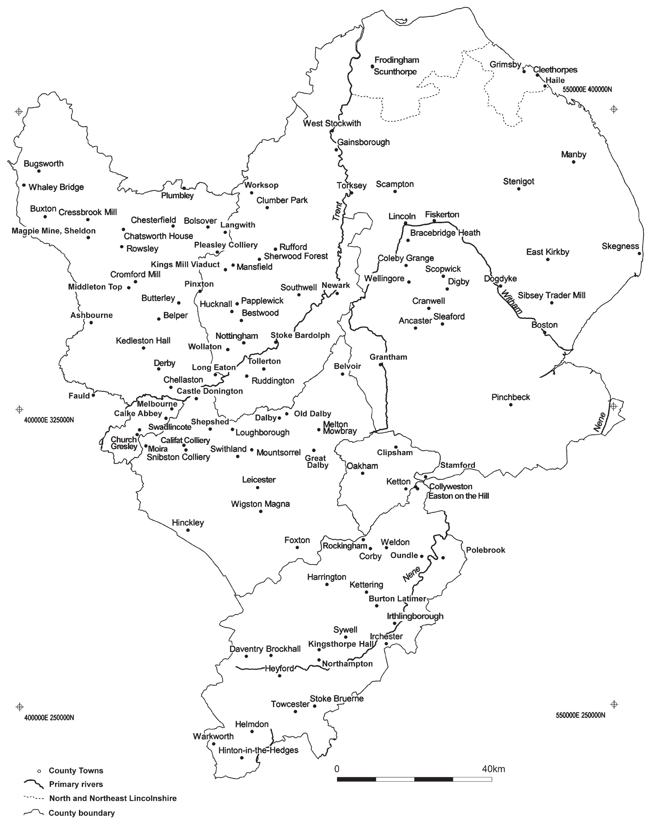
Current details of the numbers of listed buildings within the region are not readily available at the time of writing. Notable Derbyshire sites include the Cromford Mill complex (mostly listed grade I) and the nearby Masson Mill; Cressbrook Mill, Litton (grade II*); North Mill, Belper (grade I); and several buildings at the former Derby Railway Works (grade II*). Lincolnshire has the former Bass maltings, Sleaford (grade II*); Sneaths Mill, Lutton (grade I); the hydraulic engine house at Sutton Bridge (grade II*); and the Torksey Viaduct (grade II*) amongst others. Northamptonshire’s Weedon Depot retains numerous listed buildings connected with this munitions site, and Nottinghamshire’s Greet House, Upton, was formerly a workhouse, now in the care of the National Trust (English Heritage 1999a)
An additional remit of the research agenda is the identification of sites and landscapes capable of being incorporated into agri-environmental schemes such as the Countryside Stewardship Scheme that allows for research, conservation and public accessibility of targeted sites, an important aspect of wider public involvement in archaeology. Also of conservation importance are the ecological aspects of archaeological sites, rarer flora and fauna sometimes surviving only because of a site’s protected or isolated status, such as railway lines, canals, quarries and extractive sites. Campion (1997) identifies integrated management strategies for regional scheduled sites of differing periods, but these are not advanced as broad research themes here.
Aside from resource management objectives, the establishment of a research agenda seeks perhaps two academic outcomes: first, an understanding of the character of the region itself; and second, its relationship, significance and, where relevant, unique, contribution to the wider national context. A complicating factor in the East Midlands is that opinions have varied concerning its geographical extent, and what may be regarded as relevant: put another way, current political boundaries, as distinct from its geology, may artificially distort and constrain research outcomes and objectives. For example, both Lincolnshire and Northamptonshire have at different times been excluded from industrial studies of this period, and north-west Derbyshire is frequently associated with Manchester (Palmer and Neaverson 1992; Smith 1965). Similarly, the county of Rutland was until recently politically absorbed by Leicestershire, but historically has remained principally agricultural in nature, in contrast with the former.
Geographical Information Systems (GIS) are clearly of benefit to regional research and understanding, but their use should be seen as an enabling function, rather than an end in itself. Similarly, the curation of relational archaeological databases (for example the Archaeological Data Service, SMRs and English Heritage’s NMR) is accepted as an important but separate issue from that of identifying research themes. Equally, the enhancement of resource management databases managed by English Heritage, whilst important, is not a primary concern within this context. The IRIS initiative might similarly be enhanced to provide more consistent coverage of the range and depth of site recording, leading to a synthesised, integrative database providing regional and national coverage. Funding is clearly relevant here also, but is seen as a separate issue to that of what to research. The improved access to data will, however, enable that research once identified.
The following sections reflect the principal regional themes for the period: agriculture, parks, gardens, country house estates and woodland, major industries, settlements and the military context. Although treated as separate topics, many were clearly inter-related, and could not have existed without effective transport systems, workforces, the processing of natural resources, food and fuel. These sections highlight the range of publications, main themes, and representative sites and features. Fuller details of specific issues can be found in the county assessments. Following some resource assessment entries, the ‘potential’ themes reflect a broad consensus about regionally significant topics which should be explored, especially where these will contribute to a better understanding of regional uniqueness, and how this might dovetail with and enhance the national context. These bulleted entries highlight those aspects about which knowledge is currently poor. The absence of such an entry does not indicate lack of importance at the county level, only that within this specific context enough is perhaps currently understood. The principal research themes are summarised at the end of the chapter.
In keeping with its geographical context, the East Midlands reflected striking diversity during this period, as relatively early transport networks evolved and matured to encompass often disparate industries, in a mostly land-locked region. Urbanisation was hastened by this process, rapidly transforming small, agriculturally dependent towns and villages, whose locations were sometimes determined by the enduring open field system until belatedly ‘commodified’ by Parliamentary enclosure. However, it is important to stress that industrialisation did not vanquish a substantial economic reliance upon pastoral, arable and related farming activities, which remained significant throughout.
At the national level the East Midlands may be characterised as predominantly agricultural, with a significant national contribution in hosiery, lace and footwear manufacture; a series of internationally important textile mills along the River Derwent; Derbyshire’s eighteenth-century lead mining industry; and a sizeable coal extraction industry in Nottinghamshire. However, this broad sweep masks a complex process of industrialisation of many contrasts, and sometimes striking dynamism.
Regional industrialisation between 1750 and 1900 can be summarised as follows: in Leicestershire during the nineteenth century, hosiery, and later, boot and shoe manufacture, were staple industries. In contrast, Rutland relied to a significant extent upon agriculture, reflected in the stasis of its county town, Oakham. Nottinghamshire was massively dominated by the hosiery and lace industries throughout the nineteenth century, and coal for much of the late nineteenth and twentieth centuries. Northamptonshire remained rural and little altered since the post-medieval period, until the 1850s, experiencing dramatic change through the growth of boot and shoe manufacture into the twentieth century; during the mid nineteenth century its landscape underwent change through iron ore extraction. Conversely, Derbyshire’s late eighteenth-century development of water-powered textile manufacture along the River Derwent and the emergence of a system of factory labour is its most significant contribution to the pattern of industrialisation, but its extractive industries were also prominent. During the eighteenth century Lincolnshire’s main role was as a supplier of food and raw materials for London and the industrial districts lying to the west and north-west of England; only in the nineteenth century did it establish an important role in engineering for the production of agricultural machinery.
By the twentieth century many regional industries had declined, particularly textile and boot and shoe manufacture, to be replaced by new or diverse enterprises, of which engineering was prominent. Since World War 2, industry has undergone often dramatic restructuring and many are virtually extinct, such as coal and iron ore extraction, textiles and footwear. Agriculture remained throughout a significant, if turbulent, aspect of regional economic activity. Finally, two world wars resulted in the creation of numerous military sites, notably World War 2 bomber airfields, followed by Cold War observer posts.
Texts addressing aspects of regional industrialisation and settlement are varied in content and approach, but Palmer and Neaverson (1992) and Smith (1965) are quite comprehensive. Other publications include Beckett (1988), Beckett and Heath (1988), Campion (2001), Chapman (1967), Greenwood (1987) and Palmer (1994). Broadly county-based industrial overviews include, for Leicestershire, Anon. (1983); for Rutland, Palmer and Neaverson (1991); for Northamptonshire, Ballinger (1999), NIAG (2001) and Trinder (1982; 1998); for Derbyshire, including the Peak District, Crossley (1991), Harris (1971) and Nixon (1969); for Nottinghamshire, Brown (1989) and Weir (1991); and for Lincolnshire, Wright (1982, 1983).
The following overview is not definitive, but reflects broad themes. As elsewhere, research into the later twentieth century is less well represented in the region, but a valuable national overview is to be found in Stratton and Trinder (2000; see also Trinder 2001).
In many instances as settlements expanded they erased traces of earlier periods of occupation, and the continuity of land plot usage may reflect this. Industrialisation brought major changes in rural and urban settlements across the region, but its effects varied greatly, most notably in massive new housing provision. The five large county towns – Nottingham, Leicester, Lincoln, Derby and Northampton – experienced growth of different scales, characterised by substantial changes in settlement patterns, with a population shift from a rural to urban environment; conversely, Oakham, in Rutland reflected its largely agricultural dependency. The impact on towns and villages depended on proximity to transport links, resources, labour, main centres and the attitudes of landowners towards industrialisation in ‘open’ and ‘closed’ villages. The evolution of market towns was also significant across the region (Trinder 2002). The urban environment was characterised by large mixed zones added to the original core of settlements, containing a mixture of houses, factories, schools, social clubs, shops, and latterly, cinemas. The development of specialist shops was exemplified by Boots the Chemist in Nottingham (Chapman 1974). Local government functions, including school boards, burial boards, boards of health, sanitary authorities and district councils, developed during the late nineteenth and early twentieth centuries. Schools, prisons, hospitals (Richardson 1998), local government offices (Stenning 1989) and cemeteries (C. Brooks 1989), were also established. Parishes provided workhouses; an example is being conserved near Southwell, Nottinghamshire, formerly serving the Thurgarton Hundred.
Potential research topics
The research agenda meeting highlighted the need to arrive at a better understanding of multiculturalism, particularly within modern urban areas such as Leicester,Nottingham and Northampton. This represents a hitherto largely under-researched aspect of archaeological activity but the following go towards establishing a research framework in this context.
Potential research topics

Buildings from this period provide many opportunities for the evaluation of social context. The affirmation of status through building envelopes is well established, both through ostentation (or the lack thereof) and/or the careful arrangement of internal spaces (Campion 1996; M. Morris 1994; Palmer 1994, 1999; Palmer and Neaverson 1998; Tarlow and West 1999). Prisons, such as at Lincoln Castle (Fig. 60), schools, work-houses, factories, hospitals, almshouses, council offices, libraries, cinemas and industrial complexes, if evaluated spatially, may provide more detailed insights into the functional impetus underpinning plan forms, and the intentions of owners or bodies concerned to reflect commercial success or status through the medium of architecture. Similarly, the wide variety of architectural detailing used by speculative builders for terraced houses is significant, reflecting the nature of a commercial, competitive market, especially in rapidly expanding industrial towns (Campion 2001).
Potential research topics
Non-conformity continued to develop and chapels were erected in the eighteenth and early nineteenth centuries (RCHME 1986) in many industrial settlements. For example, a primitive Methodist chapel frequented by framework knitters survives in Chapel Street, Ruddington, immediately opposite the Knitters’ Museum. Shepshed in Leicestershire, also an important centre for framework knitting, had strong associations with Roman Catholicism from the 1830s onwards. Similarly noteworthy is the position of Arkwright’s church (1792-7) alongside the River Derwent at Cromford, directly visible from the mill complex itself. His workforce would pass the mill en route to worship from the village, perhaps affirming the link between religion and the work ethic (S. Gould, pers. comm.).
Cemeteries are an undervalued aspect of settlement evidence, significant for their value in terms of social status, demographics, attitudes to death and the role of religion. Similarly, the numerous cemeteries attached to, or serving the needs of the region’s Royal Air Force stations are similarly revealing: for example, those alongside RAF Coningsby, and at Scopwick church – serving RAF Digby – in Lincolnshire contain many graves of aircrew lost on operations during World War 2.
Potential research topics
Water provision was based locally on natural sources such as wells, streams, ponds and village pumps at the beginning of the period, but evolved through new technology and legislation. The expansion of towns and cities during the nineteenth century led to public services such as water, sewerage, gas and electricity. Leicester and the larger towns in the county grew in the nineteenth century, but until 1848, water supplies were obtained from sometimes-polluted wells. A Board of Health report for Wigston Magna conveys the challenges of improving living and working conditions in the mid nineteenth century (Anon. 1855). A local waterworks company was established in 1851, building reservoirs at Thornton, and pumping stations at Cropston and Swithland. The disposal of sewage from Leicester until the 1850s went into the natural watercourses causing pollution in the Soar valley. A piped system was introduced, but the removal of waste continued along the canal until the Beaumont Leys sewage farm (1891) was established, the waste being pumped up by the Abbey Pumping Station. Nottingham had its own waterworks company by 1845, and established the Boughton (1871) and Papplewick pumping stations (1884), and by the late nineteenth century the Nottingham Corporation was developing its sewage farm at Stoke Bardolph. In Northamptonshire, research undertaken on this subject was conveyed in a series of lectures at the University of Leicester’s Northampton centre, but is otherwise unpublished. A beam engine from Northampton’s Cliftonville waterworks is preserved as a working exhibit at Kew waterworks museum, and the buildings of the Rushden and Higham Ferrers Water Company can be viewed in the Sywell country park. In 1750 Lincoln and Grantham each had water conduits to provide a limited water supply, but individual householders looked to wells or cisterns.
Improvement Commissioners were established in a number of towns to provide rudimentary street lighting and policing but it was the creation of gaslight and coke companies from the 1820s that led to improved street lighting. In Leicestershire there were gas works in the county and in Leicester itself at the Belgrave site – electricity generation began at the Aylestone Road gasworks. Other stations were built at Loughborough and Hinckley, but rural areas relied upon supplies from outside the county until the National Grid system was established. The Northampton Electric Light and Power Company provided an early public electricity supply with its Angel Lane station from 1891. An archaeological record was made of the small rural gasworks at Kings Cliffe in 2000, prior to re-development. In Nottinghamshire the development of gas was complex, but is little researched. Electricity power stations along the River Trent remain a feature of the later twentieth century. In Lincolnshire several large enterprises built their own electricity generating plants, and local authorities and private companies produced electricity supplies. Electricity sub-stations remain largely under-researched. Public utilities have been assessed by English Heritage’s Monuments Protection Programme, resulting in a series of reports (Schofield 2000). Palmer and Neaverson (1992) provide a detailed overview of this subject in the region, and relevant sites.
Potential research topics
It is important to stress that much of the region’s transport system evolved to enable the import of raw materials for processing within the region’s many industries, which were then exported as finished or semi-finished goods to important external markets for ceramics, textiles, fuel and food. The availability of this flexible transport system was of paramount importance for the sustained growth of many industries and settlements. Both innovation and continuity in transport systems is evident during this period, in addition to evidence for the impact of economic fluctuations and investment in the prosperity, stagnation or decline of settlements dependent upon transport systems. Lincolnshire’s coastline both required and enabled different responses for the movements of goods and produce.
The region’s major road network frequently followed Roman roads, in turn established as turnpikes from the mid eighteenth century by acts of parliament, to improve roads in lamentable condition. These were critical to improving the movement of goods, but became less important as canals and railways evolved. The survival of coaching inns, tollhouses and mileposts across the region is erratic, but important in aiding understanding of this system. Texts include Albert (1972), Cooper (1983), A. Cossons (1934; 1950), N. Cossons (1993), Harris (1971), Hey (1980) and Nixon (1969).
The relatively early evolution of the region’s canal network during the late eighteenth and early nineteenth century was central to development, its impact extending across most counties (Palmer and Neaverson 1992, xiv). In Leicestershire, the improvement of the River Soar for navigation to the River Trent, and other schemes including the Grand Union Canal, Ashby Canal, Wreake Navigation, Oakham Canal, and Leicester and Northampton Union Canal, allowed for the movement of coal and other essentials. A trust proposes to rebuild the Foxton inclined plane (operated 1901-1911), as part of the active Grand Junction Canal. In Nottinghamshire, the River Trent was the traditional core of the transport system enhanced by links such as the Nottingham Canal, shipping coal through Nottingham, and the Chesterfield Canal from Derbyshire to West Stockwith port. In Northamptonshire the River Nene was made navigable, making it accessible to the east coast. Three canals traversed the county: the Oxford, Grand Junction, and Grand Union (Blagrove 1990). Stoke Bruerne is now the focus of a canal museum and village dramatically altered by the Grand Junction canal, and retains many original features including the canal tunnel between it and Blisworth. In Derbyshire, limestone and lime were exported along the Cromford Canal, which retains its railway terminus and Leawood Pumping Station; and the Erewash Canal, both to the River Trent. The Peak Forest canal was opened to Bugsworth and Whaley Bridge providing access to Manchester. Lincolnshire’s role as a source of food and raw materials led to the improvement of navigable rivers and new waterways: the Stamford Canal, Fossdyke Canal, the Louth Navigation, and to restoration of the River Witham. Regional texts include Boyes and Russell (1977) and Hadfield (1970).
Lincolnshire is unique in having a coastline. In 1750 Boston was still the main port, but declined after 1850; a wet dock (1882-84) improved its fortunes. Grimsby had little traffic after the Louth Navigation of the 1750s, but new docks in the 1850s led to the town becoming the major international fishing port for a time.
The region’s railway network had a negative impact on road and canal routes, as industry and passenger services migrated to this more effective form of transport during the nineteenth century (Leleux 1984). Railways were preceded by tramways and primitive railways: for example, Leicestershire’s horse-drawn waggon-ways connected collieries and limestone quarries in the north-west with the canal system and the River Soar; the Leicester and Swannington line brought coal into Leicester. During the later nineteenth century a number of railways, including the Great Central, were established to all points of the county. In Nottinghamshire early railways carried coal to the Cromford Canal: later, the Midland Counties Railway and the Great Northern Railway, using the Bennerley viaduct, provided important passenger rail connections.
Passenger branch lines were similarly established throughout Northamptonshire, also used for the ironstone quarrying industry, but railway construction is often overlooked – a research agenda for navvy camps has been suggested (M. Morris 1994; Trinder 1998). In Derbyshire demand for Peak District limestone led to the Cromford and High Peak railway, with its working Middleton Top engine house, the Peak Forest tramway and Crich mineral railway. Passenger links also developed between Derby and the county’s towns. Railways such as the Midland Railway Company similarly transformed many Lincolnshire towns. By 1856 one third of the county’s network had been opened, dominated by the Great Northern and the Manchester, Sheffield and Lincolnshire (renamed Great Central in 1897). Railways encouraged the development of holiday resorts on the coast in the late nineteenth century at Skegness and Cleethorpes. The Beeching cuts of the 1960s dramatically reduced the regional infrastructure. Texts on regional railway history include Anderson (1985; 1986) and Gould (1979).
Air transport is exemplified by the Nottingham East Midlands airport near Castle Donington, a former World War 2 RAF airfield and now the premier passenger air transport facility for the East Midlands. In addition, a number of earlier, small, inter-war airfields such as Burnaston, near Derby (opened 1939), Tollerton, near Nottingham (opened 1930), and Sywell near Northampton (opened 1928), also served the area, if only erratically in terms of air transport.
Potential research topics
Country estates have become increasingly important as indicators of social and cultural evolution (sometimes identified as ‘elite landscapes’), often closely linked to private or public buildings and houses. Significant areas of land were consumed in executing designs, representing a considerable cumulative regional total. English Heritage’s non-statutory Register of Parks and Gardens (1998c) details the basis for providing a county-based register, but inclusion can be complicated by modifications and redesigns: a garden created in the 1500s may have been dramatically remodelled by the 1800s. This process of change is reflected in the fate of many country houses, gardens and estates across the region, often having undergone dramatic change since the 1750s, either acquiring or shedding land holdings (Bettey 1993). For example, 1000 acres were added to Nottinghamshire’s parks between 1790 and 1820, and by 1873 the five largest estates controlled 137,000 acres. Subsequently, after World War 1 many of the region’s large estates were sold off, and the land divided. In tandem with the redistribution of estate lands, Nottinghamshire has lost 14 country houses since 1900, doubtless reflecting developments elsewhere.
During the twentieth century parks were acquired by local authorities, such as pre-1750s Wollaton and Rufford in Nottinghamshire, or Clumber Park (begun 1770) by the National Trust. Other Trust examples, in Derbyshire, include Kedleston Hall (begun 1759) and Calke Abbey (begun 1701; lime kilns from the late eighteenth century), both with gardens. Belvoir Castle, Leicestershire (rebuilt early 1800s), and its gardens remains privately owned, but open to the public. Paxton made changes to Chatsworth House’s existing formal gardens in the nineteenth century – its deer park being landscaped by Capability Brown in the mid eighteenth century. The house, gardens and parkland are now a significant Derbyshire heritage attraction. Northamptonshire’s numerous country house parks have been extensively recorded by the Northamptonshire Parks and Gardens Trust. Examples include Brockhall, Daventry (1790s), and Kingsthorpe Hall, Northampton (1775). Also important were the technical innovations at many country houses for water supply, sewage and food storage – icehouses were a common feature at many.
The development of foxhunting, towards the end of the post-medieval period, wrought changes in the landscape, notably on estates and the countryside in Leicestershire and Northamptonshire. New woodland, coverts and spinneys were established in addition to kennels and stables. Additionally, the hunting of game and use of duck decoys were important activities requiring structures, landscaping, grouse moors and effective drainage.
Public parks and gardens remain an important focus for recreation, universally provided in most cities and towns by municipal authorities from the mid nineteenth century onwards, a striking counterpoint to those established on private estates (Conway 1991; 1996; Elliott 1986). Designed to enhance the living conditions of industrial towns by social reformers, free access was possible where local councils used rates to maintain them. An important early arboretum (‘a place where trees are grown for study and display’) was established at Derby (1840); others followed at Nottingham (1852) and Lincoln (1872), whilst Leicester’s Abbey Park opened in 1882. Northampton’s largest parks were at the Racecourse and Abington Park, established around the fifteenth-century manor house. In the main municipal parks tend not to have retained the flower beds, vistas, boundary features and fences as originally created, frequently becoming degraded and allowed to lapse into large expanses of mown grassland. This can distort our appreciation of original design intentions and the subtle relationships of bandstands, pagodas, shelters, benches, paths, fountains and pools to long extinct floral features.
From the 1780s the region benefited from a large increase in the demand for leather goods. The bark used for tanning came from oak underwood, met from existing woods, from resources in the extensive Sherwood Forest, Nottinghamshire (White 1875), and Rockingham Forest in Northamptonshire, and other locations. Between 1780 and 1850 there was substantial use of oak, particularly for building and shipbuilding – necessitating replanting to replenish stocks. Such new plantations often included a wide range of tree species, frequently planned for both recreational and practical purposes. New plantings and forest management activities declined in the early twentieth century, perhaps reflecting the fortunes of large estates, as outlined above. Wood yards and saw mills were also significant: the Boughton and Castle Ashby estates in Northamptonshire both retained evidence for saw mills until recently, a situation doubtless reflected elsewhere in the region, but little survey work has taken place.
Potential research topics
This section identifies the strong links between farming and other agricultural activity, and the subsequent processing of produce. As stressed previously a major factor was the availability of an effective transport system that allowed for the movement of raw goods, and their subsequent export once processed.
Farming
Improvements in farming accelerated in the eighteenth century, evident both nationally and regionally from the 1820s. These included scientific systems for cattle breeding and new approaches to crop rotation and drainage. Large-scale activities included malting, brewing, flour and grist milling, and the manufacture of cheese. Animal products in the form of skins and wool provided the raw materials for shoe making and framework knitting – ultimately staple manufacturing industries. Marketing produce and natural resources required road, river and canal transport, and finally railways. Planned farms were developed away from nucleated villages on land unconstrained by earlier development or restricted land plots. Uses of technology, new crops and animal breeding became more pronounced, especially on the great estates. The development of model farms on large estates introduced new patterns of building layout into both open countryside and villages. Innovative agricultural machines had to be manufactured and during the nineteenth century, many towns had ‘agricultural implement makers’ listed.
Regionally, belated parliamentary enclosure was enacted mostly throughout 1750-1850 and had a dramatic impact on the landscape, and social and economic situation. Hoskins’ (1957) chronological study of Wigston village in Leicestershire discusses agriculture and related themes. Despite extensive enclosures Nottinghamshire’s claylands saw the survival of open fields well into the nineteenth century, extant at Laxton (Lowe 1798). The county’s ducal estates were often the focus of new innovations and investment resulting in enhanced productivity. Martin (1977) details the enclosure of Kettering, Northamptonshire, and its eventual impact upon industrialisation. Upland pasture grazing remains significant in Derbyshire’s Peak District, characterised by stone walling of enclosed fields, often shared with the earthwork remains of lead mining. Shallow soil constrained arable in these areas, but on the lowlands to the county’s south and east it was more prevalent (Farey 1811-17).
In Lincolnshire, heavily reliant upon agriculture, most open fields and common land had disappeared between 1760 and 1820 (Beastall 1978). It was the eighteenth century and early nineteenth century before the deeper fens of Lincolnshire were subdued, where scoop wheels and pumps assisted drainage – remains of wind-driven, steam and diesel engines survive at several sites, such as the Dogdyke pumping house. Later in the century, in the face of agricultural depression, fenland farms specialised in higher value crops. During the twentieth century intensive farming methods and diversification have resulted in landscape changes, particularly through the removal of field boundaries and additions of new farm buildings. The conversion of many redundant barns and other farm buildings has been widespread. Barnwell and Giles (1997) include farm case study examples from the East Midlands and the Society for the Protection of Ancient Monuments conducted a survey of barns some years ago.
Potential research topics
The archaeology of ‘improvement ‘
This section relates principally to a need to better understand the aspirations of the working-class particularly, but not exclusively, in seeking to improve their living conditions through greater control over land, produce, education and the provision of access to the means of such improvements. Northamptonshire is noted for its early involvement with such aspirations. As a subject it is capable of being included within several contexts but is detailed here because of the important link with both farming, and individual sustenance through allotments and smallholdings.
Potential research topics
Brewing, malting and food manufacture
Regionally, brewing has been a minor but widespread activity, broadly reaching a peak in the mid nineteenth century, but declining thereafter. Prior to the nineteenth century brewing was mostly a domestic industry supplying local markets, followed by substantial growth in the early nineteenth century, and a technological revolution from the 1850s often prompted by national markets. Broadly, commercial breweries only appeared in most towns after 1780. Remains of the industry include disused or converted maltings, and former brewery buildings.
In 1855 there were 83 maltsters and 20 brewers in Leicestershire, but dramatically fewer by the 1930s. In Nottinghamshire malting grew from a small-scale industry into large urban commercial enterprises (Patrick 1977; 1996). Newark was the most important centre, exporting beer to Europe by the late eighteenth century (Sheppard et al. 1993). Northamptonshire had large commercial breweries and malt houses in the main market towns – its brewing history has been documented (Brown 1998), but there has been relatively little archaeological work with the exception of recording work at the Northampton Brewery Company, Phipps Brewery and the Anchor Brewery (NIAG 1970; Starmer 1970a).
Derbyshire’s involvement was constrained by its diverse geology, but malting was significant in Derby, supplying national markets in the early eighteenth century, and at Langwith. The processing of barley for beer was an important industry in Lincolnshire – by 1856 there were 163 maltsters, with Sleaford and Grantham notably supplying national markets. In the 1750s breweries were often small undertakings, but during the nineteenth century and early twentieth century firms grew larger, taking advantage of the railways in barley growing areas. Boston was important but many associated structures have gone or are threatened. Diversification into new and exotic crops and fruits was also significant (Thirsk 1985). The temperance movement in the late nineteenth century led to the growth of county mineral water manufacturers.
Food production based on agricultural produce is well represented. Dairying, producing milk, butter and cheese commercially, was an important Peak District activity, based around Ashbourne (Harris 1971), also covered in Trinder’s (1993) comprehensive account of the food industry in Derbyshire and elsewhere. The manufacture of Stilton cheese occupied many significant Leicestershire dairies (Hickman 1997), and the Melton Mowbray pork pie is similarly of national significance (Hickman 1995). In many large towns commercial bakeries were established often through co-operative societies; good examples survive in Kettering and Northampton.
Potential research topics
Milling
Industrial corn and grist milling based upon wind and water-power – the latter enduring for a considerable time – was extensive in the region, but many sites have been lost or converted. The continuity of water-power throughout the region in textile and iron manufacture is also noteworthy (see below). Subsequently, population growth during the nineteenth century resulted in the construction of steam mills. Leicestershire had many water mills, but the lack of high ground providing falls of water restricted their size (Ashton 1977). A map survey c. 1980 identified 113 sites, with few retaining machinery. Of windmills, some 160 sites have been confirmed, the majority with no standing remains – even fewer retain sails or are complete with machinery. Moon (1981) has researched examples in Leicestershire and Rutland while Henry (1988) concentrates on Rutland. Nottinghamshire’s mills survive to varying degrees (Brown 1989; Weir 1991, 114): Green’s restored windmill, Steinton, Nottingham, is a working museum.
Northamptonshire mills have been identified through documents and fieldwork (Starmer 1970b; Stainwright 1991): Starmer is currently surveying all water and windmill sites to assess survival since the fieldwork of 30 years ago. Derbyshire’s numerous water mills made good use of water supplies especially in the Peak District, of which Rowsley corn mill, adapted for roller milling, is a noted example, but windmills were few in number (Harris 1971; Nixon 1969). In Lincolnshire, water-powered mills in the west and on the Wolds fulled cloth and made paper, as well as grinding. Windmill technology in Lincolnshire reached its peak in the nineteenth century. Brick tower mills were constructed, such as the Sibsey Trader, built in 1877. The county’s numerous windmills have been widely researched (Dolman 1986; Wailes 1991). Others served the needs of agriculture, such as the oil seed crushing mills, and later nineteenth-century fertiliser factories. Following World War 1 the government sponsored several sugar beet factories.
Potential research topics
Extractive industries
The region has a variety of minerals ranging from coal and fireclay, limestone and roadstone, to sand and gravel in the extensive low river valleys (Hewlett 1979). Beginning with ironstone, in Leicestershire its extraction has left considerable landscape remains, including workings, inclines, cuttings and tunnels of the extensive railway system which serviced the quarries. The modern ironstone quarrying industry in North-amptonshire originated in the 1850s, running until 1980 (Tonks 1989; 1990; 1991; 1992). Important sites include Irchester Country Park and Easton on the Hill. Within the clays of the lower coal measures of north-east Derbyshire, Chesterfield, Bolsover, Amber valley and the Erewash, the availability of ironstone led to a local iron and steel industry, but this is little researched. The quarrying and smelting of ironstone in Lincolnshire started in the 1860s in a rural setting, expanding to become the town of Scunthorpe.
Limestone was found both in the north-west and east of Leicestershire, Derbyshire and Northamptonshire. It was burnt to produce lime for agricultural improvement, and mortar and cement for building. Kilns were constructed at quarries, or alongside canals or rivers where the stone could be brought closer to fuel supplies – a Derbyshire SMR search identified c. 100 entries relating to lime kilns (Hill 1986). There are exceptional eighteenth- and early nineteenth-century industrial lime kiln complexes at Grin Hill, near Buxton, the Peak Forest, and also fine later nineteenth-century bank kilns at Millers Dale, Buxworth. A large complex of limekilns is preserved at Calke on the property of the National Trust (Marshall et al. 1992). In Lincolnshire, limestone quarries for Ancaster building stone were exploited to the west of Sleaford. Northamptonshire’s Irthlingborough cement works was a significant consumer within the county.
The quarrying of stone, sand and gravel remains an extensive industry in Leicestershire, producing slate, granite and roadstone. Local buildings testify to the durability of Swithland slate and Mountsorrel granite. In the east of the county there were freestone quarries at Clipsham and Ketton. Northamptonshire’s extractive enterprises were the stone and slate quarrying industries with large quarries at Weldon, Helmdon and Collyweston, the latter’s slate industry of national importance. The peak years for the industry were 1715-1730, with the rebuilding of Stamford and Oundle. Large numbers of former quarries shown on OS maps indicate that farmers also had individual slate pits. Gravel extraction in the county continues, reflectedin large areas of open water in the Nene valley. In Derbyshire, other building materials including freestone were available. The Tarmac company’s involvement in Derbyshire included sand and gravel extraction. The creation of millstones and pulpstones was also significant, with a number of sites extant (Tucker 1985). In Lincolnshire, developments at Scunthorpe generated interest in mineral working in the county, where opencast or underground mineral mines were opened on a minor scale.
Coal deposits in Leicestershire, Nottinghamshire and Derbyshire have made an important impact on the regional and national economy (Gould and Ayris 1995; Green 1935a; 1935b; Owen 1984). Conversely, Northamptonshire and Lincolnshire had little or no accessible reserves. Coal mining tended to work shafts for long periods – excluding shallow mining – with the result that surface buildings were renewed, destroying earlier structures, but below-ground archaeology often survives. Leicestershire’s industry, on a relatively minor scale, was located in the north-west of the county, but little survives above ground – the Snibston heritage centre retains original features and Neaverson (2000) investigated Califat Colliery.

From the 1750s coal was the most important export from Nottinghamshire, and significant nationally (Griffin 1981). Small-scale mining up to the late eighteenth century on the exposed coalfield was transformed during the nineteenth century into the major deep pits of the twentieth century. In 1860 there were 21 collieries, spread over a wide area and by 1910 output stood at 11 million tons. There are few nineteenth-century remains, but the Bestwood engine house survives (Fig. 61). From the late nineteenth century to the inter-war period the coalfield enjoyed investment in technology from companies such as Barber-Walker. In the 1920s eight new pits were sunk in the Dukeries area, to the north and north-east of Mansfield, and company villages and settlements established, especially during the inter-war period (Waller 1979; 1983). New markets emerged in the mid twentieth century supplying the power stations along the River Trent. In Derbyshire’s eastern coal field open-cast extraction has erased many traces of earlier mining – projects examining early mining remains are being undertaken. To the east of the surface outcrops is the concealed coalfield where nineteenth-century deep coal mines and mining towns grew, such as Pleasley Colliery, whose engine house and headstocks survive. In the Peak District there are exceptional surface remains of coal extraction near Buxton, and sites including Barlow Colliery and Ringinglow are also of national importance.
The eighteenth century saw the growth of companies with interests in both coal and iron production, including the Butterley Company and the Stanton Ironworks Company, which became the largest colliery owner in the Midlands during the later nineteenth century. In the eighteenth century a preference for coke as a fuel promoted the coking industry, notably for the iron and steel industry, where attempts to control levels of sulphur were found necessary after other approaches, notably coal, were found to be unsatisfactory. A later use was made of coke in the railway industry. Prior to the eighteenth century coal was coked in open stacks, but gradually banks of beehive coke ovens were built and used at collieries across the region, but few now survive, such as those at Unstone, Derbyshire.

Lead mining was a significant industrial activity in the Derbyshire Peak District, where traditional pastoral land use has enabled lead working remains to survive, but they are under ongoing threat (Barnatt 1995b, 1996d; Ford and Rieuwerts 2000). The cyclical nature of the industry has seen the periodic working, abandonment and reworking of deposits, with the loss of earlier workings. Studies tend to focus on the larger-scale mines after the mid eighteenth century but smaller-scale mining of earlier periods is less researched: remains include engine houses, gin circles, buildings and processing floors. Typically, these include dressing floors, buddles, crushers, ponds and water management features in varying states of preservation. The introduction of improved smelting techniques attracted investors and larger companies, who took up leases on small mines (Crossley and Kiernan 1992; Nixon 1969; Willies 1969). Investments in steam powered de-watering pumps and the driving of drainage levels, or soughs (Rieuwerts 1966), enabled mines to be sunk to previously inaccessible ore deposits, as at Magpie Mine, Sheldon (Fig. 62). Following the completion of the Monument Protection Programme, the scheduling of some 35 sites reflects their significance (Schofield 2000). The pioneering research of the Peak District Mines Historical Society remains important.
During this period Nottinghamshire’s gypsum extraction industry continued to grow and by 1908 it produced half of the total UK output. Gypsum was used for lime ash floors and plaster, but also for medicines, fertilisers, bleaching, plaster of Paris and ornaments. Extraction methods during the nineteenth century included open casting and deep mining. Of the early industry little now survives. In Derbyshire, gypsum deposits suitable for the production of plaster of Paris, and blocks of alabaster for religious and secular ornamentation were exploited around Chellaston. In Lincolnshire, gypsum for flooring was extracted in the Isle of Axholme.
Until recently little attention had been given to the exploitation of Derbyshire’s upland peat deposits by individual farms and whole communities as a primary source of fuel. The detailed farm surveys of Edale and the Upper Derwent Valley by the Peak District National Park Authority are revealing the network of trackways that serviced quarries and peat extraction areas.
Potential research topics
Clay and related products
Once widespread on a local basis, brick pits existed at many towns and villages, but there are now few remains. Many supplied newly developing towns, canal or railway construction sites. O’Rourke (1970) surveyed Northamptonshire sites. Clay was extensively used for roofing tiles, providing an important industry in Lincolnshire. Improvements in agricultural methods required tile drains for poorly drained fields, used extensively across the region.
The use of local clays in the manufacture of china ceramics, pottery and earthenware products was important in eastern Derbyshire, notably in Royal Crown Derby porcelain (Palmer and Neaverson 1992, 159). Porcelain production was also notable at Pinxton and Torksey in Derbyshire, the latter site yielding large quantities of evidence. Trade networks to import ball clay from the south-west, and then to export finished goods were important, as was the availability of calcined flint for clay bodies and flint-kiln sites capable of such processing. The production of white salt-glazed stoneware and cream ware in Derby (c. 1760-1790) is intrinsically linked to the availability of non-local materials.
Additionally, the brown salt-glazed stoneware manufacturers were widespread in Derbyshire, but have been little studied archaeologically. Such wares were exported widely with some examples finding their way to North America, seemingly a major market during the eighteenth and nineteenth centuries. The south Derbyshire industry including Swadlincote and Church Gresley were significant manufacturers of yellow ware during the nineteenth century, the latter still producing white wares. The widely exported products of the county raise important issues about material culture, transportation, markets, materials and production systems. Despite these, only small-scale excavations have taken place at Swadlincote and Melbourne, with the result that South Derbyshire is one of the least studied areas of ceramics manufacture despite its importance. As a separate issue, the manufacture and distribution of clay pipes also warrants attention regionally.
Potential research topics
Textile mills
Textile manufacture was a significant, diverse regional industry. Throughout the period it had been at the forefront of innovation and enterprise, but new technology was taken up erratically, with many textile mills continuing with earlier forms of motive power. Nottingham was important for its early involvement in cotton spinning, where Arkwright’s first mill of 1769 employed 300 by 1771, before moving to Cromford. There were a number of textile mills in Nottinghamshire by the 1790s, of which the Robinson’s cotton mills on the River Leen were the first in the country to use steam power (Greatrex 1986-7). Chapman (1967; 1981-2) offers valuable accounts of textile mills in the region. Northampton’s cotton mill of 1742 was an early, moderately successful enterprise, continuing in use for some twenty years.

Derbyshire, however, witnessed the first successful harnessing of water power to manufacturing technology, leading to a factory-based system of mass production and innovative relations of labour. Lombe’s silk mill of 1721 in Derby is believed to be the earliest in Britain and a reconstruction is in Calladine (1993). The use of cotton in hosiery had been hampered by the problems of maintaining a supply of thread of suitable quality. Arkwright adapted machinery for water power at Cromford in 1771. This is held to be the first successful water-powered cotton-spinning mill (Fig. 63); a second was constructed in 1777 and has recently been excavated. The Cromford Mill complex is significant, contrasting with the nearby Masson Mill of 1783. Arkwright also initiated a workers’ colony (Chapman 1976). From 1776, Strutt and Arkwright developed mills at Belper for mechanised cotton spinning using the River Derwent (Cooper 1983). Between 1776 and 1816, six separate mills were constructed, with housing (Barley 1961), communal buildings and farms, transforming it from a small village reliant upon nail making (Robson 1964). At Darley Abbey, the Boar’s Head Mill was established for cotton production along with community housing including an early sewage treatment plant – English Heritage plans further survey work (Menuge 1993). The Derwent valley mills have been formally inscribed as a World Heritage Site, reflecting their unique level of survival (DVMP 2000). Derbyshire has other cotton-spinning sites of note, such as the Cressbrook (c. 1783) and Litton mills (1782), on the River Wye, a tributary of the Derwent.
Leicestershire took no part in the introduction of powered carding and spinning of cotton: steam powered spinning of wool and worsted emerged during the late eighteenth century. Many mills were built during the early decades of the nineteenth century – there were 38 wool or worsted spinning mills in the county in 1838. Yarn production also gave rise to a number of merchants’ warehouses. Northamptonshire’s cottage industries included weaving, wool-combing and silk making, but did not progress to textile mills on any scale, except, notably, the Burton Latimer worsted mill of 1847. Lincolnshire had little success with the textile industry, despite several enterprises (Chapman 1967).
Potential research topics
Hosiery and lace: outworking and factories
Northamptonshire’s hand-made lace industry was on a significant scale during the earlier part of this period, but few identifiable buildings remain – the survival of lace school and lace merchants’ premises has not yet been gauged through specific survey. Areas of Nottinghamshire, Leicestershire and Derbyshire had a significant involvement with the framework knitting outworking industry, widespread by 1750, continuing until c. 1870, when it declined into the twentieth century (Chapman 2002). Production occurred in houses, or workshops, often attached to master hosiers’ dwellings. Building survivals are erratic, but have been widely studied (Campion 1996; 2001; 2004; Palmer 1994; 2000; Smith 1963; 1965). Two museums, at Wigston, Leicestershire, and Ruddington, Nottinghamshire, are based in former framework knitting buildings (Campion 2005). In Leicestershire, outworking was increasingly supplanted by the boot and shoe industry from the 1870s. Frame making was an important regional industry providing the foundations for late nineteenth- century and early twentieth-century engineering.
A growth in powered hosiery production (by steam, gas, oil or electricity engines) resulted in multi-storey factories from the 1860s in main towns and larger villages. By 1895, there were 231 hosiery manufacturers in Leicestershire. Its elastic web manufacture evolved in the 1850s, in which several factories specialised. Hosiery in Nottinghamshire remained outside the factory system until the 1850s, when Hine and Mundella’s factory opened in Nottingham, encouraging other entrepreneurs. Essential support functions were the dyeing and finishing works, of which Leicester and Nottingham had many; wholesale and retail networks were also significant. Throughout the twentieth century the industry declined steadily and many buildings have been adaptively re-used or demolished. The research of such factories has been erratic.
The home-based lace industry evolved from framework knitting, centralising in nascent factories from the 1820s. Machine innovations provided impetus to lace technology: Heathcoat’s bobbin net machine (1810) was significant in escalating Nottingham’s economy, where 1820s and 30s housing survives (Campion 2001; 2005; Mason 1994). From the 1820s steam engines for lace manufacture were introduced. Lace factory expansion took place outside Nottingham’s limits in the 1870s, for example, Beeston’s Anglo-Scotia Mills and other mills in Long Eaton. Tenement factories occurred where lace firms shared space and power sources, but the industry declined through the twentieth century. The Nottingham Lace Market is a significant survival. Between 1851 and 1877, 71 factories and 41 warehouses were built in the Saxon Burgh area of the city, many in the Lace Market including the Adams building on Broadway (Beckett 1997; Mason 1994; Oldfield n.d.)
Potential research topics
Boot and shoe: outworking and factories

Boot and shoe manufacture, and its associated trades, were significant in Leicestershire and Northamptonshire during the latter half of the nineteenth century, but far less pronounced elsewhere in the region. In Northamptonshire this industry evolved out of earlier craft-based activity, itself a major national supplier of footwear from at least the later eighteenth century. From the 1850s a transition to national supply came with the development of machines enabling bulk production, making both counties significant nationally. However, mechanisation was erratic and it was not until the 1890s that separate processes were contained within single factories. Prior to this, in both counties, the industry was based upon an outworking system using garden and yard workshops for much of the period 1850-1900, but it had largely declined by the century’s end (Campion 2001; Kirby et al. 1988; Morrison with Bond 2004; Palmer 1994; Starmer 1982; Trinder 1998). The system was not dissimilar to framework knitting, where small workshops were a feature of houses in Leicestershire villages close to the city, and numerous towns and villages in Northamptonshire – north-west Kettering is a significant surviving example (Campion 2001; Trinder 1998). In Northamptonshire particularly, the industrialisation of the boot and shoe industry had a major effect on town and village settlement patterns (Greenall 1975). In both counties shoe manufacturers built factories within streets of speculative, or co-operative society terraced housing in a number of towns and villages. St Michael’s Road, Northampton reflects this mix of large factories and terraced housing (Fig. 64). Leicester’s CWS Wheatsheaf Works (1890s) was then the largest shoe factory in the world.
In contrast to the hosiery trade, the boot and shoe industry had a considerable warehousing element, both for raw materials and finished products, some of the latter belonging to shoe chain stores, both manufacturing and retailing footwear. There was also a large supporting industry for the boot and shoe trade in both counties. Tanning, leather dressing and preparing were major elements, along with the manufacture of specific elements of boots and shoes, as well as polishes and dubbin. Companies also specialised in the manufacture of machinery, tools and cardboard boxes for the shoe trade. The industry declined during the twentieth century, with the re-use or loss of many factories.
Over many years, significant research has been undertaken on the boot and shoe industry, especially on documents and its products. Research on buildings associated with the boot and shoe industry in Northamptonshire by English Heritage has concluded (Cooke et al. 2000; Menuge 2001; 2004). Northampton Museum and Art Gallery has both a nationally important collection of boots and shoes, and a significant range of boot and shoe making machinery.
Potential research topics
Iron and steel manufacture, although not a major industry within the region, was still significantly represented. In the seventeenth and early eighteenth centuries water-powered furnaces provided the basis for the iron smelting industry. The coincidence of ironstone, streams for waterpower, and supplies of charcoal from the extensive woodlands of the area promoted the growth of the industry. The region has two of the earliest surviving coke furnace sites in Britain: Moira furnace, built c. 1804-6, in Leicestershire (Cranstone 1985); and the Morley Park ironworks built in the 1780s, near Ripley, Derbyshire (Riden 1988; Palmer and Neaverson 1992, 36). The iron industry was not significant in Nottinghamshire: by 1907 the county was producing 205 tons of iron.
Iron smelting was closely linked to ironstone quarrying in Northamptonshire in the nineteenth to twentieth centuries. Iron ore was smelted at a total of 12 sites (1857-1981) – by 1945 only four iron furnaces remained working (Beaver 1951). The majority of iron ore blast furnace sites have been largely destroyed – Towcester and Heyford are of potential archaeological value, but less survives at Corby. Instone (1970) undertook a survey of foundries in Northampton, later extended to cover Northamptonshire as a whole (Starmer 1981). Starmer (1970c) also conducted extensive survey on ironworks. The late eighteenth century saw the evolution of a number of major iron companies and sites in Derbyshire, which all grew through the late eighteenth to early nineteenth century. The Butterley Company initially supplied cast iron rails and wheels for horse drawn tramways, troughs for canals, and cast iron beams. The Codnor Park works of 1807 at Butterley became a major supplier of wrought iron. Their rolling and forge welding of plates and bars enabled the construction of the St Pancras railway station roof. Yet, as a source of primary iron, Derbyshire’s industry began to decline after the 1850s. Cheaper ironstone was available in Northamptonshire, making local manufacture uneconomical. In Lincolnshire the Trent Iron Works was built at Frodingham from 1862.
Regionally, all industries, including agriculture, required support trades; these were established mostly between 1780 and 1840, often in urban settings. Some towns and cities subsequently achieved international prominence through the success of engineering firms of which Lincolnshire has notable examples. Its first engineering works were established in Boston, producing steam driven threshing machines, exported worldwide. After 1840, Hornsby in Grantham, and Marshall in Gainsborough achieved prominence. Likewise, Clayton and Shuttleworth, Ruston, Foster and Robey in Lincoln contributed to the city’s international importance, and during World War 1 firms were involved in aircraft production making the city the largest centre of production in the world (Walls and Parker 2000; Wright 1982). The mechanisation of hosiery and footwear production gave rise to a large number of machine makers, forming the basis of an extensive engineering and iron-founding industry. In Leicestershire many engineering companies developed, specialising in a limited range of products including boot and shoe machinery, textile machines, machine tool making, electrical engineering, lifting equipment, cranes and typewriters. By 1911, in Leicester alone, engineering employed nearly 3% of the population, its firms making a considerable impact on its economy, and growth of support services. Other companies made civil engineering and quarry plant for the county’s extensive extractive industry. In Northamptonshire a large number of firms provided machinery for the boot and shoe trade, but firms not connected with this industry existed before this, for example Harris and Clayton, producing beam engines, of which an example is displayed at the Henry Ford Museum in the USA. In Nottingham, Campion began cycle manufacture in 1860 in addition to his hosiery concern. An employee of his, Humber, made tricycles, building a factory for cycle manufacture in Beeston (1880); in 1908 Humber moved to Coventry. Nottingham’s Raleigh Cycle Company grew out of a small firm to become one of the leading cycle manufacturers in the world. John Player and Sons remain a major manufacturer in Nottingham, making use of production machinery (Mason 1981). Rolls Royce in Derbyshire remains a major engineering company within the region (Pugh 2000; 2001), its wartime role noted in the next section.
Military themes of the last century were not addressed in academic terms to any great extent until recently, a situation being reversed through the Defence of Britain Project and English Heritage’s assessments of military remains. County SMRs hold information to varying degrees of completeness about both the twentieth century and preceding periods. During the eighteenth and nineteenth centuries barracks are the most enduring symbol, but they survive erratically. In Northamptonshire, Gibraltar Barracks in Northampton and the Royal Ordnance Depot at Weedon Bec are notable (English Heritage 1999b). Nineteenth-century military encampments are rare, as is evidence for military field-works. Militia drill halls featured in many towns, but their numbers are declining.
Twentieth century
The region was militarily significant during the twentieth century, especially in the two World Wars and the subsequent Cold War (Cocroft et al. 2003), and is surprisingly rich in both remains and significance (Lake 2000). This is recognisable largely through now isolated features, such as pillboxes, searchlight and anti-aircraft batteries, command and observation bunkers, and in the plethora of airfields. Additionally, training camps, Prisoner of War camps, supply depots and transport installations are represented.
The region boasts a significant link with military aviation, particularly Lincolnshire, through its association with the RAF in both the First and Second World Wars with the establishment of bomber airfields during the latter conflict, some used by the USAAF (Barrymore Halpenny 1981; Blake et al. 1984). Between 1939-45 the region had 96 airfields (Fig. 65) within the counties of Lincolnshire (45), Leicestershire (14), Rutland (3), Derbyshire (4), Nottinghamshire (14) and Northamptonshire (16) (Blake et al. 1984; Gibson 1982; Willis and Holliss 1990). After the war, many bases were returned to use as agricultural land and few survive intact, though some sites have been re-used for post-war industrial estates, or the broken up concrete runways as hard-core for modern motorways elsewhere. War memorials, as distinct from military cemeteries, at many former airfield sites may be one of the few clues as to their former use (Ingham 1995).
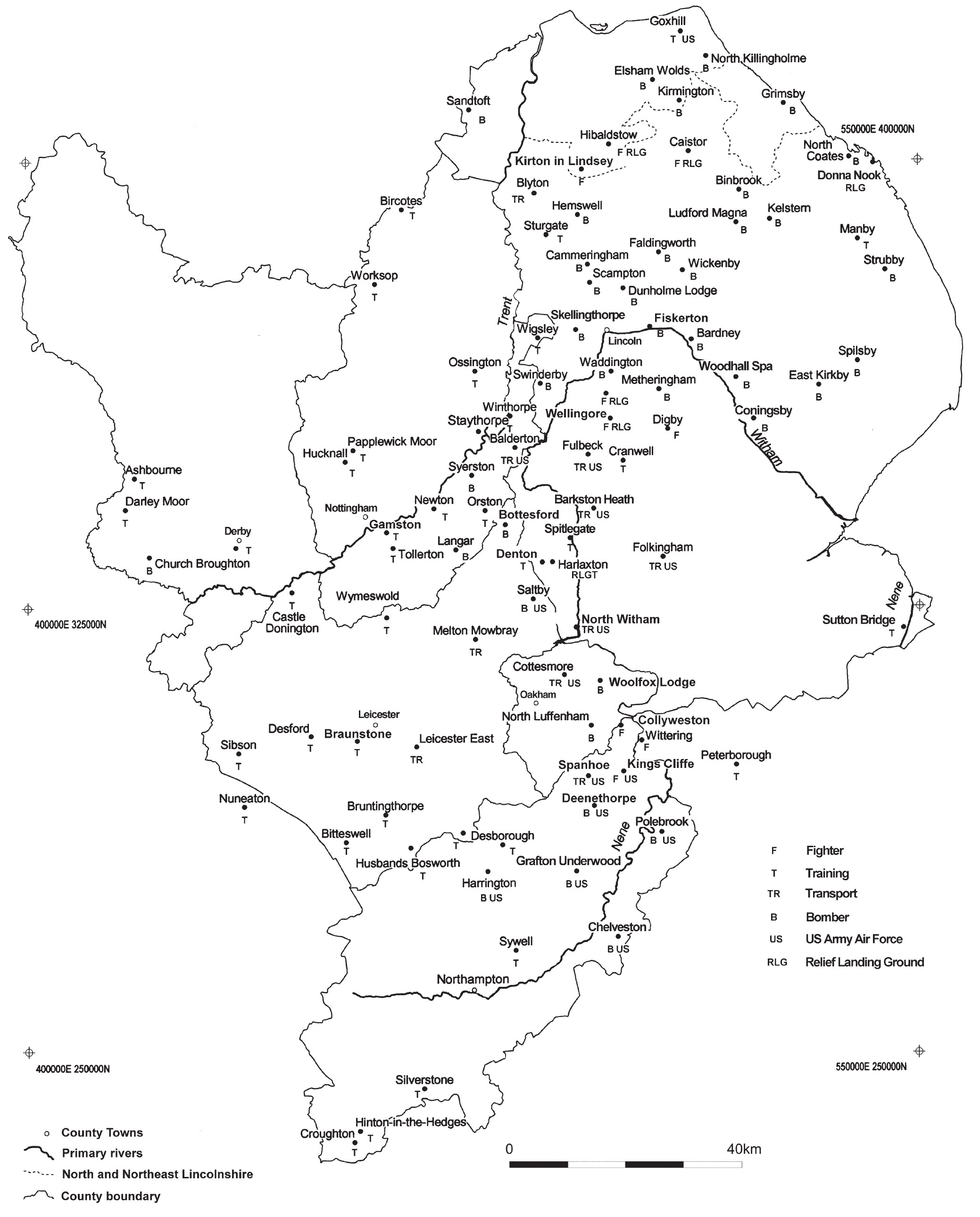

Lincolnshire airfields assessed under English Heritage’s listing survey, which retain important buildings include Cranwell, East Kirkby (with its restored control tower), Manby and Scampton – famous for its connection with the Dambusters and now the base of the Red Arrows display team (English Heritage 2000b). Additional airfield sites of significance include Bracebridge Heath, Lincoln (important World War I hangars and associated buildings; Fig. 66); Harrington and Polebrook’s Cold War THOR sites; and both Hinton-in-the-Hedges and Tollerton for airfield perimeter defences – pillboxes, Bofors-gun positions, observation posts and dispersed aircraft blast shelters (often known as ‘E’ pens, reflecting their shape in plan). RAF Digby, Lincolnshire, has a restored 1939-40 Sector Operations room museum within the camp boundary, as well as E-pens around its original flying field. Its nearby fighter airfield satellites of Coleby Grange and Wellingore (Fig. 67) retain some features; respectively a 1941 control tower at the former, and E-pens at both.

The RAF’s Battle of Britain Memorial Flight is based at RAF Coningsby, Lincolnshire, along with its visitor centre and guided tours of airworthy aircraft,including Hurricanes, Spitfires and a Lancaster. Other small Lincolnshire museums exist at former RAF Metheringham and near RAF Cranwell. Nottingham’s Newark Air Museum features examples of military and civilian transport aircraft.
The Defence of Britain project focused upon anti-invasion defences (Lowry 1996). Several coastal defensive sites are noteworthy including the Freiston shore coast battery, the Haile sand fort and the network of pillboxes in Boston Haven. Inland there are 54 extant pillboxes on the Burton to Ashbourne 1940 invasion Stop Line, and some 25 dispersed pillboxes.Derbyshire and Northamptonshire lay behind the static anti-invasion defences and lack evidence for Stop Lines or associated defences (Alexander 1999). Radar and Cold War early warning sites survive to varying degrees: Stenigot in Lincolnshire has extant World War 2 and Cold War radar structures (Osbourne 1997; 2004; Cocroft et al. 2003) and Fiskerton’s Royal Observer Corps HQ bunker complex is also important (ibid.).
Royal Ordnance factories producing munitions were located in the region. Stratton and Trinder (2000) provide a detailed assessment of war production both nationally and regionally, including specific sites. Supply sites included depots at Dalby, Chilwell and the Fauld bomb store (the last in Staffordshire). In Northamptonshire major munitions factories from World War 1 at Warkworth are now represented by extensive earthworks; the Abbey Works in North-ampton, which was active in both world wars, has recently been investigated.
Other examples of World War Two manufacturing, storage and development survive at Weedon Depot, used for aircraft parts assembly and repair, in Northampton and at Armstrong-Whitworth’s Sywell plant at Corby for work on ‘Pluto’ and the ‘Mulberry’ harbours. Borough Hill in Northamptonshire was a focus for early RDF (radar) experiments and aircraft navigation systems. At Tollerton in Nottinghamshire, Field Aircraft Services Ltd repaired Lancasters and other military aircraft during the war years. Rolls Royce was a major aero-engine designer and manufacturer, in addition to its work on tank engines. Its Derby Nightingale Road car works of 1908 remains significant, where aero-engines such as the Spitfire’s Merlin were designed and developed before and during World War 2, and tested at the company’s main test-centre, Hucknall airfield, Nottinghamshire (Pugh 2000; 2001; Ritchie 1997). Jet aircraft with Rolls Royce engines were subsequently test flown from Balderton, Nottinghamshire, during 1943-4 (notably Whittle’s Meteor jet trials) and Church Broughton, Derbyshire, where concrete runways were available (Barrymore Halpenny 1981, 113). In addition to aero-engine development, Rolls Royce used Hucknall as a repair site for fighter aircraft during the Battle of Britain in 1940.
Potential research topics
The areas of research potential highlighted above form a series of inter-dependent networks that constitute a significant key to an accurate understanding of regional development and diversity. Notably, this reflects an awareness that settlement patterns are imperfectly understood, but are central to an understanding of the social and cultural context of industrialisation – or the lack thereof. It is also striking that these non-prioritised research objectives point away from single sites and technology, moving instead towards a broadly historical archaeological agenda in terms of the ‘people’ aspects, and the understanding of relationships between sometimes disparate themes. This represents a continuum from earlier periods of regional archaeology, placing the modern period in its appropriate context and provides a solid foundation upon which to craft further gains in knowledge.
The broad research themes can be summarised as:
Settlements: the transition from the post-medieval period; the nature and impact of settlements; plot ownership; workers’ colonies and paternalism; issues of ‘power and control’ in building types; the adaptive re-use of industrial buildings; civic buildings; intra-settlement facilities and relationships; nascent settle-ments; prisons, schools, and workhouses; the nature of entertainment; the archaeology of consumption; the impact of public utilities.
Multiculturalism: the nature of twentieth-century settlement patterns; cultural diversity; religious buildings; industrial activity; approaches and perceptions regarding the cultural heritage.
Religion and cemeteries: types, locations, buildings, use of materials, social context.
Transport systems: inter-relationships between different types; inter-dependency; the impact of transport on industrial and settlement development; construction sites; what now survives; twentieth-century airports.
Landscapes: estates, parks and gardens, woodland: social context and influence; distribution; new technologies; relationships to industrial settlements; what survives; woodland industries.
Farming and the processing of its products: the relationships between enclosure, settlement and industry; the distribution and nature of planned, model farms; the context of estate farming; rural agricultural industries; the archaeology of (self-) improvement – freehold land, tied cottages, allotments, education; milling and malting.
Extractive industries: underground workings; the inter-relationships of workings to markets, settlements and communities; the transport context; building stone; slate and stone industries; the industrial context of brick making; ceramics manufacture; clay pipe manufacture.
Textile mills: the inter-relationships of mills in economic and landscape contexts; continuing survey work of early mills and water management systems; the juxtaposition of outworking to mill production; gender roles in working systems; the adoption of or resistance to new technologies.
Outworking: pre-1850 craft industry buildings of all types, and what survives; the relationships between craft industry and/or outworking to factories; the transition from framework knitting to boot and shoe; pre-1850 organisation of the Northamptonshire boot and shoe industry; the impact of ‘open’ and ‘closed’ villages.
Military sites: the nature and survival of sites from 1750-1914; defensive and offensive facilities; the industrial contribution to production; the impact of warfare on former peacetime production; wider context.
Particular thanks are due to Nick Cooper for overseeing this ambitious project and ensuring its smooth and effective management. The invaluable work of county curatorial staff and the authors of the individual county resource assessment documents for the regional research framework – Dr Andy Myers, Jenny Ballinger, Neil Wright, Ursilla Spence, Mike Bishop, Peter Neaverson and Dr Mike Osborne – is also gratefully acknowledged. Grateful thanks also go to Professor Marilyn Palmer, Dr Barrie Trinder, Stephen Young, Suzanne Stenning, Richard Buckley, Geoffrey Starmer, Steve Dobson, Graham Cadman, David Barker, John Barnett and Ken Smith for their comments. Philip Ellis provided valuable assistance concerning regional scheduled monuments. Steven Denny and Alison Mackay provided information about regional parks and gardens. Finally, appreciative acknowledgement is made of the many contributions offered during the discussion sessions for this period.