John McNabb With appendices by Roger Jacobi and Simon Collcutt
Click here to see how to contribute
The aims of this chapter are:
To realise these aims, a ‘bird’s eye’ approach to presenting information has been followed, rather than concentrating on themes such as transition or stasis. In part this is necessitated by the huge time span the Palaeolithic encompasses (98% of the time Britain has been occupied by people). In addition, many people view the subject as a murky specialism very different from ‘normal’ archaeology, a situation compounded by the woeful lack of up to date period-based syntheses (a poor reflection on Palaeolithic archaeologists). In consequence, many people feel put off by the subject and have little real liking for it. It was felt that the approach followed here was the best way to allow people to gain a broad understanding of the period, and the significance of the East Midlands Palaeolithic resource. In the interests of creating what I hope is lively reading, some speculations are offered at certain points in the report. These are clearly marked as such. Conjectures in this vein are useful as they can present research possibilities.
Palaeolithic archaeology draws its primary data from two sources, the recovered archaeological record, and the geological record. The former comprises a melange of stone tools and organic remains, which reflect the interaction of humans with these media. These can be either items with which ancient humans directly interacted – knapped stone, cut marked bone, anvils with battering etc – or organic items with which ancient humans did not directly interact, but which have a bearing on human activity, for example unmodified bones, dated by radiocarbon, which can provide a terminus post quem or terminus ante quem for archaeological data.The geological record represents the remnants of the depositional environments within which the traces of ancient human activity came to rest. It is an important source of information on the physical context within which human action was played out. Depositional environments play an important secondary role in Palaeolithic archaeology, as they serve as curatorial entities, preserving the archaeological record which Pleistocene sediments either contain or seal. They thus have important functions in both preserving and enhancing the understanding of that record.
The following text is set against the model of British Pleistocene development proposed by David Bridgland (2000). This model is the latest in a series of attempts to unite climatic change with the Oxygen Isotope sequence, and to seek to link these with river terrace development (Fig. 7). Like all models, it inevitably suffers the curse of over-generalisation, but nonetheless it provides a dynamic and up to date outline of the geological and climatic background to the Palaeolithic archaeology of Britain and the East Midlands. It is important to us because one of the principal foci of human settlement for much of the Palaeolithic appears to have been the river valley, and therefore river terraces track the spatial and temporal extent of Palaeolithic settlement. Since the staircase of a river’s terraces record the history of that river’s development, they can also preserve evidence of major changes in the character of Palaeolithic material culture over time. River terraces are thus coarse-grained time capsules that preserve changes in Palaeolithic time and Palaeolithic space.

Clive Gamble (1995) has argued persuasively that traditional views of human occupation during the Pleistocene are rather naïve. Traditionally, glacial periods have been seen as too cold for people to be living in Britain, and occupation was thus restricted to interglacials. During the intensely cold middle portion of each glacial phase, occupation in Britain would certainly not have been possible. But climatic modelling, archaeology and geology have combined recently to make it clear that portions of the early and late phases of a glacial period could, and did, permit human occupation, being times of cool but not intensely cold climate. What is more, the early and late phases of interglacials were also times of cool as opposed to warm climate. So between the glacial and interglacial maxima, there were long phases of transition when conditions were not too extreme to preclude occupation in Britain. In Figure 8, I have schematically illustrated these transitional phases, giving the transition from late glacial to early interglacial the label ‘transition A’ and that from late interglacial to early glacial ‘transition B’. This is simply for the sake of making the text that follows easier to read.
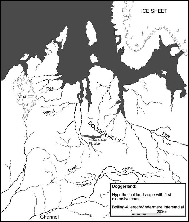
For much of these transitional phases the sea level would be low, either retreating as a glaciation began, or slowly rising as an interglacial began. This would mean that considerable areas of the continental shelf, during transitional phases, as well as full glacial conditions, would have been dry land for many thousands of years. Britain would have been the western end of a vast plain (i.e. the southern North Sea basin), connecting the east of the country with the northern European coastline and with Scandinavia to the east. The name Doggerland (Coles 1998) has recently been applied to this area. Figure 9 reproduces Coles’s hypothetical reconstruction of Doggerland during the Windermere Interstadial (13,000-11,000 ya), making a very dramatic point. Britain, for much of the Pleistocene (i.e. during transition periods A and B and glacial maxima) was the western end of Doggerland, and the Palaeolithic archaeology of Britain, and the East Midlands, is thus the archaeology of western Doggerland. Even during the height of some inter-glacials this landmass may have been quite considerable. For example Oxygen Isotope Stage (hereafter OIS) 7 is known to be a low sea level interglacial relative to OIS 11 or OIS 5e (although the level was no lower than at the present day), and contains within in it (OIS 7b) an intensely cold phase that is classed as a mini-ice age when sea levels would have been correspondingly lower.
David Keen (pers. comm.) has noted that at the end of a glacial (transition A), sea level rise would be rapid, and there may not have been much time during transition A when land exposure was prolonged. This may be true for some interglacials, but not necessarily all. Using the end of the Pleistocene as an analogue (i.e. from c. 13,000 ya onwards), it is clear that the build up to the point when current interglacial sea levels were achieved was a complicated one. Western Doggerland and Doggerland were habitable before the boundary (Windermere interstadial) and after it. Coles’s (1998) hypothetical reconstruction of late Pleistocene and early Holocene Doggerland makes another dramatic point. The full breaching of the barrier between the Channel and the North Sea may have occurred as late as 7,000-5,000 ya (and possibly later), when sea level finally reached levels comparable with earlier interglacials. From c. 10,000 ya until that point, the history of the southern North Sea is the history of a gradually diminishing southern Doggerland.
The Bridgland model and the geography of the North Sea basin has been considered at some length since it will structure our understanding of the whole of the British Palaeolithic archaeological record as presented here. The link between river terraces, the OIS framework, and the possibility of occupation in transitions A and B, represents one of the most important frameworks through which British Pleistocene archaeology will be conducted in the coming decade. Any regional East Midlands synthesis must therefore take account of this.
Like all archaeological periods (in themselves utterly arbitrary impositions of structure on time), the Palaeolithic labours under the tyranny of tripartite subdivision into the Lower, Middle, and Upper Palaeolithic. Whilst these do reflect some genuine differences in the record, as with any exercise that chops up a continuum, only the central portion of each reflects a clear distinction from the central portion of adjacent subdivisions. The traditional subdivisions of the Palaeolithic, along with more recent revisions, are outlined in Figure 10.John Wymer (1999) makes the first attempt, to my knowledge, to structure the Palaeolithic in terms of the Bridgland model, although he uses an earlier version of it. While following Wymer’s lead to a certain extent, recent work on the Upper Pleistocene has argued for a long abandonment of the British Isles during OIS 6-3, a period of over 120,000 years (Currant and Jacobi 1997). This forces a new perspective on the archaeology of the pre-and post-abandonment phases. It is not really possible to group the archaeology before the abandonment and after it into a single monolithic Middle Palaeolithic whole on the basis that people in both times used Levallois technology. In OIS 3 Neanderthals are the re-occupiers of western Doggerland, and it is thus legitimate to apply the term Mousterian to this phase. Prior to the abandonment, the Levallois-using biface makers are either very early Neanderthals or very late Homo heidelbergensis, but nonetheless quite different from their successors. This outlook raises some daunting methodological problems which will be outlined in their appropriate sections. In order to compare the framework through which the data for this report have been constructed with other such frameworks, the scheme is included in Figure 10.
For the sake of consistency the convention ‘ya’ (years ago) has been adopted to indicate a date in thousands of years (e.g. 270,000 ya); where individual radiocarbon dates are quoted these will be presented as calibrated BC unless stated otherwise. The basic subdivisions of the Late Pleistocene that fall within the limits of the radiocarbon method have been drawn from two basic sources (Jöris and Weninger 1996; 1999). Laboratory numbers are included for individual dates.


The full framework is presented in Figure 11. However, the scientific precision implied by the single year date boundaries shown should only be considered in an heuristic fashion.
The Chapter Format
Information is divided up under two broad headings for each of the archaeological periods considered. Readers should refer to Figure 11 in order to situate themselves. For each period, the text is organised along the following lines:
This format will address aims 2 and 3 as outlined above. Aim 4 is covered by the bibliography. The final section addresses Aim 1, giving a holistic Palaeolithic view to the regional synthesis. Aim 5 is realised through Appendix 2 by Simon Collcutt.

Older textbooks speak of the Cromerian Interglacial as preceding the Anglian glaciation (now taken to be OIS 12). This was a logical consequence of the simple three glacial, three interglacial sequence advocated by Pleistocene geologists in the 1970s, and supported by terrestrial pollen data. With the wide-scale adoption of the OI sequence, the ‘Cromerian’ of the old system has been demonstrated to be a poor reflection of the true complexity of Pleistocene climate before the Anglian. The name Cromerian has been retained as a label for the interglacial immediately preceding the Anglian (see Fig. 11). This is the Cromerian sensu stricto (hereafter s.s.). However, the label Cromerian is also applied to the four interglacials that precede the Anglian and which form part of the European faunal/stratigraphic Cromerian complex. In order to avoid confusion in Britain we label this as the Cromer/Cromerian complex, or the Cromerian sensu lato (s.l.).
For Archaeological Period 1 it is possible to divide western Doggerland into two heuristically defined regions. The eastern region incorporated East Anglia (including counties adjacent to the Wash) and the Lower Thames valley. The western and southern region incorporated the Upper and Middle Thames valley and all points south, to the Channel. North of the Thames, it would include the area to the east of the eastern boundaries of Derbyshire, Leicestershire and Northamptonshire. The East Midlands therefore sits between the two regions and connects them by virtue of the Bytham river as described below. As will become evident from what follows, the main research questions for Period 1 are as follows:
The western and southern region
There is good evidence for pre-Anglian Lower Palaeolithic settlement in this region. It also shows hominins successfully occupying a variety of ecological zones. Kent’s Cavern near Torquay in Devon contains flint bifaces, flakes, and cores, which are associated with Cromerian (s.l.) faunal indicators such as the extinct bear Ursus deningeri. These deposits are much older than the 350,000 ya date returned on the speleothem that seals the deposit (Straw 1996). It is unlikely that hominins lived in the cave. The archaeology has been washed in from above through avens in the roof. During transition A and transition B, when occupation would have been possible, the site would have looked out on a broad plain; southern Doggerland would have been separated from modern France by a river flowing westwards out to sea (Fig. 9 above). Of particular interest here is the suggestion by Cook and Jacobi (1998a), that the technological character of the thick, often trihedral, hard-hammer flaked bifaces is sufficient to associate them with other such bifaces in the Somme valley terraces of northern France. The French examples, formerly called Abbevillian, may date to OIS 16/15. No other Period 1 bifaces in Britain are remotely similar.Boxgrove in Sussex, like Kent’s Cavern, represented coastal occupation at times of higher sea level. To the south, the now lost eastward-flowing Solent river curved round the Isle of Wight to flow south toward the channel river. To the east, the Weald-Artois chalk ridge separated the Channel valley from the North Sea. From sediments at Boxgrove, in particular Unit 4b of the Slindon Silts, it is apparent that the sea was close to the site. The occupation zone, up against a chalk cliff, was separated from the sea by an off-shore bar which created a lagoon environment. During the subsequent Unit 4c times, the sea had retreated by some distance and the site represented the landward end of the emerging coastal plain. This was a rich environment which late Cromerian (s.s.) gatherer-hunting peoples exploited, but apparently did not camp on (Pitts and Roberts 1997). The artefact distribution through these shallow marine sands indicates a hominin presence well back into the interglacial, encompassing at least two high sea level sub-phases (Collcutt 1999). The Boxgrove evidence suggests episodic exploitation of hunting or scavenging opportunities. The lowering sea levels associated with Unit 4c indicate the end of the Cromerian (s.s.), and the beginning of the climatic downturn leading to the Anglian.
The evidence for occupation in the pre-Anglian Upper and Middle Thames is sparse. Southern tributary rivers of the ancestral Thames, which at this time flowed up through the Vale of St Albans and then north-eastwards past Clacton-on-Sea (Fig. 12), contain a few deposits with clearly derived artefacts, which may date to the Cromerian (s.l.). Other deposits in the Middle Thames, such as the high level Gerrards Cross Gravels also contain a few bifaces. It would appear that a late Cromerian (s.l.) to early Anglian presence may be suggested in this area, but the evidence is questionable, and if genuinely reflecting occupation, it was sparse.

Two further sites are of importance to this western and southern region. The first is Westbury-sub-Mendip. This is an ancient collapsed cave containing Cromerian fauna and a number of lithics which, for a long time, were hotly disputed as artefacts. Recent work (Barton 1997) implies that these pieces, now much rotted and difficult to interpret, were originally chert. As with Kent’s Cavern, the cave itself was not occupied, but the archaeology attests to Cromerian (s.l.) use of the hill slopes above the cave. The location of the cave suggests it was reached in three possible ways; along what is now the Bristol Channel, via lowland routes such as that occupied by the modern river Culm, or across the North Dorset Downs. The latter route was certainly unglaciated, but the former lay close to the south-western Anglian ice margin. At Waverley Wood in Warwickshire, south of Coventry, interglacial sediments were recovered from beneath Anglian age till. The warm climate organic sediments also contained three bifaces made out of andesite, a lava almost certainly derived from the Lake District. There were a small number of quartzite artefacts as well. Wymer (1999) has speculated whether this location indicates a possible route of entry into Britain up the equivalents of the modern day vales of Gloucester and Evesham. Hominins could have exploited resources moving up the southern margin of this corridor.
One problem of course is the Channel river. If a major stream, this would have provided a major obstacle to movement across the Channel plains. But on the basis of current evidence, occupation was never extensive, more likely the result of opportunistic movements when conditions were favourable and accessible routes were open. The fortunes of the Channel river would have varied as do modern rivers. Alternatively, hominins may have crossed the Weald-Artois ridge, and then moved along the northern edge of what would have been the Channel valley, paralleling the high ground now represented by portions of the south coast. Considerable opportunities would have existed for moving inland up river valleys, or continuing westwards.
The eastern region
As already noted there were two main lines of communication connecting the southern and western regions with the eastern region in the pre-Anglian, namely the ancestral Thames and the Bytham rivers (Fig. 12). We can speculate that the southern and western region may have been populated either from across the broad valley that would one day become the Channel, and then overland northwards, or up the line of the present Bristol Channel. This would have been dry land since the westernmost coast of Doggerland would have been well to the west of the modern Irish coastline. This is speculative, of course, and based on projected land exposure modelled on lowered sea levels. The reason for highlighting these routes of entry is that the Lower Thames is mysteriously lacking in any convincing evidence for humans at this time. Occupation of the southern and western region may not have come from this direction. This is made all the more surprising by the presence of unequivocal evidence for occupation along the Bytham river to the north. Either of these streams may have been a tributary of the other, and may, in some way, have been connected to the Rhine. This was certainly one route of entry into the eastern region.Along the Bytham there are a number of sites, two of the most celebrated being Warren Hill and High Lodge. The former has recently been reinterpreted as Early Anglian, because its sediments are at a lower altitude than Bytham sediments ought to be at that point in the river’s profile (Lewis 1998) . However, it contains rolled bifaces implying derivation from earlier Cromerian (s.l.) land surfaces. The material from this site is for the most part bifaces, and stands in contrast to the core, flake, and flake tools from the near-primary context site of High Lodge. This site, excavated by the British Museum (Ashton et al. 1992), introduces another element into the Period 1 archaeology. As a non-biface assemblage it begs the question of how it relates to the biface assemblages of this period, and to the non-biface assemblages of the late Anglian and early OIS 11 that are labelled Clactonian. These are discussed in a later section. What makes High Lodge all the more interesting is that its assemblage is characterised by scrapers, including single convex side scrapers made by semi-abrupt retouch. High Lodge has been interpreted as a non-biface assemblage, but these kinds of scrapers only occur in biface assemblages!
Here we may speculate on some of the five research questions posed for this section:

As noted, strategically the East Midlands sit between the southern and western regions, and the eastern region. Occupation in Archaeological Period 1 could have theoretically come from the south-west, the south or the east. No East Midlands sediments from this period have as yet been known to contain archaeology, even though the potential for Bytham river sediments to do so is high. In addition, the potential for East Midlands Bytham sediments to contain organic materials, which are critical to our reconstructing Period 1 environments, is very high indeed. Bytham river sediments pass under Leicester and parallel the Soar, upstream of its confluence with the Wreake, subsequently following the lower reaches of the modern Wreake itself. In all these areas, gravel quarrying could possibly reveal Period 1 sediments with archaeology. Collcutt (1999) notes that wherever artefacts have come from Period 1 in this area, they are always in or near deposits of the Brooksby group of sediments. These are temperate deposits and they underlie the Bytham Baginton Formation sediments (Rice 1991, 39), which are equated with a cooler climate and from which no certain archaeology has yet been recovered. The implication posited by Collcutt is that all archaeology from this period and in this area recovered to date, comes from these pre-Bytham temperate Brooksby sediments. This applies to the Waverley Wood bifaces noted above, and other artefacts from Rearsby, Brandon Pit, and the neighbouring Pool Farm Pit (Fig. 13).
Reinforcing this point are the sediments recently noted beneath the Rearsby Brook (Challis and Howard 1999), a small tributary of the Wreake, which emphasise the critical importance of conducting watching briefs on these sediments. They contain Brooksby Group organics (shell, peat, wood and charcoal), which have enormous potential for modelling the environments contemporary with hominin biface makers in Archaeological Period 1.
The Cromerian (s.l.) landscapes of Derbyshire, Nottinghamshire and Lincolnshire are focused on the, as yet, incompletely understood drainage systems of the Proto-Trent, Proto-Witham (a tributary of the Proto-Trent) and the Proto-Humber. Much disagreement between specialists exists on which river left what deposits where, and when. Drainage for these major streams is dictated by three gaps in the physical relief of Lincolnshire and southern Humberside, since each sought an outlet onto east central Doggerland through these gaps. From south to north these were the Ancaster Gap, through which flowed the Proto-Trent from the Vale of Belvoir; the Lincoln Gap, through which flowed the Proto-Witham (which joined the Proto-Trent beyond the Lincoln Gap in the Lincolnshire vales); and the Humber Gap, centred on the present Humber estuary, through which flowed the Proto-Humber. Not all authorities are agreed on this picture: some argue that the Ancaster Gap and Vale of Belvoir are Anglian or post-Anglian features (Wymer 1999).
If till limits are anything to go by, the Anglian represents the most extensive glacial episode of the British Middle Pleistocene. However, the Anglian was not a single monolithic ice age, as the OI record preserves evidence of at least two interstadials, which may have been warm enough for western Doggerland to be re-occupied. During transitions A and B occupation may also have been possible, and there is a small body of evidence which suggests that there were people around at these times. This sets the primary research agenda for this latter part of Period 1.
At the height of the Anglian, Britain would almost certainly have been uninhabitable. A testament to this is the depth of solifluction gravels that cover Boxgrove, a result of mass wasting off the South Downs during the Anglian, the ice margin for which was north of the modern Thames valley. There is little definitive evidence for extensive Early Anglian occupation, although there must have been some overlap during the transition B phase. We have already noted that Lewis (1998) has re-dated Warren Hill on the Bytham river to an Early Anglian age. In addition to the rolled and derived series of artefacts, there are fresher ones that we may speculate should be broadly contemporary with the early Anglian deposition of the gravel. Wymer (1999) quotes the work of Phil Gibbard who noted a small number of bifaces from a gravel he believed to be Early Anglian at St George’s Hill, Weybridge. Early Anglian occupation may be demonstrated in the Silchester Stage gravels of the Kennet and on the plateau around Tilehurst, but these are open to some doubt. The Boundstone Channel is a gravel channel cut into Terrace A at Farnham. Numbers of artefacts occur in these gravels, but again, fixing them within the Anglian (if indeed they belong there) is difficult. So, extensive Early Anglian occupation is not supported. The great sheets of Early Anglian gravel in the Middle Thames, known as the Winter Hill Gravels, are archaeologically sterile. However, some occupation, at least at Boxgrove, is clearly present in the earlier phases of the Anglian. Unworn bifaces and manufacturing debris, some of it refitting, has been found in silt units stratified within the cold stage solifluxion gravels noted above.
At the height of the Anglian, the ice fronts lay across northern London. Two large pro-glacial lakes existed, apparently fed by northward-flowing drainage truncated by the ice sheet. The modern Thames valley was formed when these two ice-dammed lakes burst their banks (or, at the very least, the easternmost lake) and a dynamic torrent of water flowed into a narrow pre-existing valley system. The first gravel deposit associated with the new Thames valley is the Black Park Gravel, now all that remains of this catastrophic event.
For the Late Anglian, most of the evidence of occupation is again centred on the Thames valley. At Hillingdon there are collections of artefacts in Black Park Gravels. The most dramatic evidence, however, comes from the Caversham Ancient Channel near Henley. Here, significant quantities of artefacts – cores, flakes, bifaces and scrapers – were recovered from a Black Park Gravel-filled channel abandoned by the river when it sought a new channel. These pieces must date to the Late Anglian. There is nowhere else they can have come from, since the preceding gravel terrace is the sterile Winter Hill Terrace. Wymer (1999) speculates that there may have been an unrecognised warm stage in the Late Anglian (presumably after the last Anglian interstadial?), but freely admits the evidence is flimsy. The Bridgland model as followed here resolves this difficulty since occupation would have been possible in transition B. Once the new Thames river regime had quietened down and the stream begun to re-sort its first aggradation, there would be nothing to prevent people from inhabiting the area.
Not surprisingly, the Anglian ice obliterated the former Cromerian landscape, and drainage patterns altered accordingly. The Bytham river was completely destroyed. Most of the East Midlands would have been covered in ice, although at times, southern Leicestershire was just south of the fluctuating ice margin. Anglian-aged sediments from this area indicate the presence of a huge ice-dammed lake, known as Lake Harrison. Its northernmost position was around Leicester, but it extended as far as Coventry, Rugby and Leamington. Remnants of these lake deposits (the Wolston Clays and Silts) have been mapped to the south of Leicester, and extensively around Hinckley and Nuneaton. This lake was a major feature of the Anglian Midlands landscape, and another pro-glacial lake is known from the Birmingham area. They must date to interstadials or to either transition A or B times.
Significant changes were initiated in the northern Lincolnshire reaches of the East Midlands drainage pattern. The Lincoln Gap was blocked by ice, which left a chalky till and an outwash deposit known as the Eagle Moor Sand and Gravel. As yet there is no real agreement as to which rivers occupied which courses on the resumption of temperate drainage. Authorities dispute the ascription of particular key fluvial sediments to particular streams.
Considerable spreads of till/boulder clay cap much of the East Midlands. On the British Geological Survey maps, most of these are not differentiated into named glacial units. There is a continuous spread from the East Midlands into East Anglia, with the interdigitation of particular till facies demonstrating the overall contemporaneity of many of the units. The Thrussington Till and the Oadby Till in Leicestershire interdigitate with the Lowestoft Till of East Anglia, and the whole is taken to be an Anglian-aged deposit because the Lowestoft Till underlies Hoxnian-aged interglacial sediments at Hoxne in Suffolk.
A few artefacts have been found associated with Anglian till or outwash suggesting the possibility of a human presence, but it is equally likely that such pieces were planed off earlier surfaces and simply incorporated into these sediments. Alternatively, they may date to later deposits which lay on the tills, but which have long since eroded away leaving the artefacts on the surface of the more intractable glacial deposit. Consequently, to date, no intra-Anglian occupation of the East Midlands can be demonstrated.
This is one of the most well-researched periods in the British Palaeolithic. In particular, OIS 11 seems to be well represented in terms of occupation. Sites along the Thames, and along the fossil drainage lines of East Anglia have been studied for over a century. In recent years the Thames in particular has provided new stratigraphic information, as the OIS record, faunal studies, stratigraphy and amino-acid dating have coalesced in a single model to explain terrace formation and the likely time-spans for human occupancy. This is the Bridgland model as followed in this chapter. The research agenda for this period is as follows:
The resumption of west to east drainage may have provided the main routes of hominin return into western Doggerland. The Bytham was destroyed by the Anglian ice, but the Thames now flowed along part of its modern valley before turning sharply northwards in what is today its estuary, and flowed up the line of the Essex coast before turning east at Clacton-on-Sea (re-occupying its pre-Anglian valley) to become a left bank tributary of the Rhine. At Swanscombe, these early Thames deposits have a suite of molluscs which identify its connection with the Rhine, and which are also present in the contemporary Clacton deposits.
The archaeology of early OIS 11 is dominated by two apparent traditions, one manifested by a series of assemblages without bifaces, known as the Clactonian, and the other, with bifaces and therefore subsumed into the Acheulean tradition. In a major reinterpretation of the Clactonian/Acheulean dichotomy, Mark White and Danielle Schreve (2000; White 2000) have argued that in late OIS 12 and early OIS 11, the archaeological record supports re-occupation of western Doggerland by non-biface making peoples, who are then replaced by biface makers (or they adopt biface making as a strategy) in the middle of the interglacial. This pattern then repeats itself exactly for OIS 10 and the succeeding OIS 9 interglacial. However, the pattern is confined to OIS 12-9. After late OIS 8, the presence of Levallois technology signifies a change in the re-occupation pattern or demographic character of north-western Europe.
Occupation during Archaeological Period 2 is strongly centred on eastern and southern Britain. In part, this reflects the interests and home ranges of earlier archaeologists and the locations of major mineral extraction programmes, close to Victorian urban areas. However, this is not the only explanation. River valleys do seem, on the face of the available evidence, to have provided routes of entry inland for mobile gatherer- hunting peoples. Moreover, re-colonisation could have occurred from the south/south-west or the east. OIS 11 demonstrates occupation in a number of different ecological zones. Biface makers are at home on high ground (Wymer 1999) as well as in river valleys (ibid.), and are present in both forested environments as well as more open ones (McNabb and Ashton 1995). Occupation is also noted on the margins of lakes as well as rivers. The data also demonstrate that some localities may have been repeatedly revisited, or at least certain areas were continuously peopled. Swanscombe for example, shows a continuous presence of hominins throughout OIS 11, implying that the Thames was a constantly traversed route. The floodplains of river valleys may have represented some of the most open areas of land available, especially during the interglacial maxima.
It has been argued that hominins may have had to abandon areas of Britain during the height of the interglacials, as forest cover would have been too dense, and movement restricted to game trails, with all their attendant dangers. However, sites like Beeches Pit and Barnham (Ashton, Lewis and Parfitt 1998; Wymer 1999) in Suffolk, dated to OIS 11, make it clear that people could be present during the forested portions of interglacials. Barnham is on a river channel margin but Beeches Pit is on a smaller stream or spring line system. Both have pollen and faunal evidence for fully temperate environments. These sites reinforce a strong relationship to water, and to river or stream environments. Gamble (1999) has proposed that resource exploitation in Archaeological Periods 1 and 2 was dominated by encounters in the course of daily foraging, rather than through pre-planned exercises. From late transition A through to early transition B, a hominin’s perception of their world may have been very narrow, limited to what Gamble terms ambulatory perception. In other words their understanding of the world was constructed around the paths they took to move through that world. It would not be pushing speculation too far to envisage game trails and paths (ibid.) linking static resource locales, such as useable flint gravels or defendable places. This begs the question of social and technical change between the more open and arid phases of the climatic cycle, and of the social insularity that Gamble argues interglacial forests would have imposed.
Very few sites can be confidently correlated with OIS 10, even if no major ice sheets existed. White (2000) notes that the Clactonian site of Little Thurrock can be placed in late OIS 10/early OIS 9 on stratigraphic grounds (Bridgland 2000), and the non-biface assemblages at Cuxton and Purfleet (Greenlands Pit), in the lowest portion of each sequence, are similarly positioned. Sites that can be placed firmly within OIS 9 are equally rare. At both Cuxton and Purfleet, both of the non-biface assemblages are succeeded by biface assemblages that, it is assumed, date to later in the same interglacial (White 2000). Two other noted biface assemblages at Stoke Newington and in the Wolvercote Channel, are also placed within temperate OIS 9. The famous Acheulean site of Hoxne is dated to later OIS 9 (Lower Industry) and early OIS 8 (Upper Industry) on the basis of amino-acid ratios (although faunally it may date to late 11 and early 10; White and Schreve 2000). It is of interest that many of these locations perpetuate the pattern of a waterside association, but also demonstrate a persistent occupational pattern at the same place. Acheulean occupation during late OIS 12-early OIS 8 is thus ecologically and geologically varied, and may exhibit patterns that transcend mere taphonomic considerations.
We can speculate that the post-Anglian landscape was one of new rivers in new courses, as well as old rivers re-occupying former valleys. In many of the places where former ice-dammed lakes existed, or kettle holes in the tills had appeared, there were temperate lakes filling with fine-grained sediments. The interglacials were possibly as warm as today, and the faunal record was one of a rich variety of woodland and open woodland forms.The evidence for humans from this phase in the East Midlands is frankly very poor. It is quite possible to argue a case that denies any occupation north of Peterborough during Archaeological Period 2, or at least the early part of it. Hoxnian (OIS 11) interglacial sediments are present at Hitchin, in the Chilterns, associated with lake deposits, but contemporary sediments north of this do not contain convincing evidence of human presence. Neither the interglacial clays at Stoke Goldington (south of the southern Northamptonshire border), nor the famous Woodston deposits on the Nene at Peterborough (south of the Leicestershire border) contain any certain evidence for Archaeological Period 2 occupation (Green et al. 1996; Horton et al. 1992). Within the East Midlands the closest deposits that could contain Period 2 deposits are those of the Upper Nene valley in Northamptonshire. However, there are taphonomic difficulties with identifying archaeology in the Northampton Nene terraces. Wymer (1997) notes that the terrace structure around Northampton indicates that the gravel aggradations there are late in date, probably Late Pleistocene, and that consequently the palaeoliths contained therein could well be derived from earlier deposits (most are mapped as coming from the lowest terrace or from alluvium). It is possible that these derived artefacts date to Archaeological Period 2, but then they often occur with Levallois pieces (i.e. Archaeological Period 3), which are also present in the terrace gravels. Keen (pers. comm.) notes that this is a common problem with the post-Anglian rivers, where terraces pre-dating stage 9 simply do not exist, a lacuna possibly explained by land ice in OIS 10, 8, or 6.
North of the Nene, in the valleys of the Soar, Wreake, Trent and associated Trent streams in south and north Lincolnshire, there is no convincing evidence for Archaeological Period 2 occupation, or at least the earlier part of it. Any Period 2 archaeology may have been incorporated into the sediments of Archaeological Periods 3 or 4 if the glaciers responsible were post-OIS 8. Alternatively, we may speculate that since the Nene flowed into a deep marine embayment resembling a fjord, near Peterborough, this east to west barrier (river and fjord) was too big an obstacle to cross.
Whatever the reason, there are no convincing deposits of OIS 11-9 in the five East Midland counties, and ‘sites’ in the Thames or East Anglian sense, are certainly not present.
For many researchers, the introduction of Levallois into the British Palaeolithic record marks the beginning of the Middle Palaeolithic, a period which continues until the advent of anatomically modern humans sometime at or before 33,000 ya (based on a radiocarbon date for the human jaw from Kent’s Cavern cited below). Many researchers such as Wymer (1999) see the Mousterian (defined here as Archaeological Period 4; Fig. 11 above) as a direct continuation of the Lower Palaeolithic. My reasons for splitting this up have already been discussed; the two different approaches are set out in Figure 10 above.
Period 3 presents Palaeolithic archaeologists with a unique set of conundrums, representing both research questions and issues of a more basic methodological nature. The problems are as follows.
Levallois technology appears towards the end of OIS 8 in the British Isles (Bridgland 1998; Wymer 1999). From this point in the record, we see examples of radial, convergent, and parallel (flake blade and laminar) prepared core technology (PCT), also known as Levallois. However, these do not replace the biface, flake, and flake tools of the Acheulean, since they appear in association with these assemblages. The relationship between Levallois and the Acheulean has never been unequivocally explained, but the majority of researchers assume that the Levallois is a technological phenomenon, a new way of making things, that is grafted onto the basic Acheulean repertoire. PCT tracks change in Acheulean society. It is not the sudden appearance of a new tool type or technology that effects change, rather, that ‘new kit’ is the outward manifestation of broader changes in the social fabric of the hominins who lived in Archaeological Period 2. Once PCT appears within the broad span of Acheulean variability, it continues to be made until the end of Archaeological Period 3 as defined here. In effect the Levallois is an aspect of the Acheulean. However, it is important to note that not every Period 3 site need have Levallois, so how do we distinguish a Period 3 site without PCT from a Period 2 site?
When the Mousterian peoples bring their material culture (Period 4 as defined in this report) into Britain in OIS 3, they also make PCT. Without careful stratigraphic and chronological control, and the presence of (for want of a better phrase/methodology) diagnostic stone tools to act as type fossils, how do we distinguish Period 3 from Period 4? This is particularly relevant to the East Midlands where many of the Levallois finds are in derived contexts, in and on low-lying river terraces that may be Late Pleistocene in age.
This is not the place to begin to explore these issues in detail. Wymer (1999) flags them as continuous problems in his discussions of his version of Period 3 (see Fig. 10 above). Currently, open sites have to rely on the correlation between terraces and the OIS record. For late OIS 8-late OIS 4, where those terraces can be placed in the OIS sequence and are clearly prominent above their river’s floodplain, any Levallois artefact can only be contemporary or earlier than the aggradation that contains them (ibid.). On the presumption that Britain is abandoned between the middle of OIS 6 and OIS 3, any artefacts in such terraces have to relate to Period 3 and not to Period 4. More caution must be exercised with artefacts in terrace gravels from OIS 3 and 2, however, since it is very possible that these contain artefacts reworked from earlier Archaeological Period 3 terraces. Clearly this model only holds good for archaeology stratified within the terrace sequence, or unmixed archaeology whose provenance can be confidently attributed to a terrace aggradation. Surface finds must therefore be treated with extreme caution for obvious reasons. In addition to this issue of confident identification, research priorities for Period 3 are as follows:
The evidence for occupation in Period 3 is impressive, and denotes some interesting changes in spatial patterns, supporting the notion outlined above that new social landscapes were shaping physical ones. Following the Bridgland model, Period 3 begins in late OIS 8. Wymer (1999), however, notes the possibility of a Proto-Levallois in the area of Purfleet in the Thames valley, also observing that it is not in evidence anywhere else. It is defined on the basis of platform preparation, apparently unaccompanied by shaping of the Levallois flaking face (technically this cannot be PCT since it is the shaping of the surface from which removals will be detached that defines the technology, and so I would strongly argue against the continued use of this term.). This is based on sites dated to early OIS 8 such as Botany Pit and Greenlands Pit. Until more examples in stratigraphic contexts are forthcoming this must remain unresolved. The most famous British Levallois locality is Baker’s Hole (Wenban-Smith 1995), currently dated to late OIS 8 or early OIS 7 (Wymer 1999). From this site the quintessential concept of Levallois cores and flakes was generated. Almost every textbook on the Palaeolithic shows examples (usually the same two or three) of large radial Levallois pieces representing the classic tortoise cores and flakes.
In general, Period 3 occupation appears quite widespread throughout the Thames valley, although the number of medium to largish sites (arbitrarily defined) are few. Most of the assemblages are biface assemblages with a few associated PCT flakes or cores. Important exceptions are sites at West Thurrock and Crayford where Levallois floors have been discovered. The latter is an important working floor with a large quantity of Levallois laminar (blade) technique in evidence, much of which was refitted by Flaxman Spurrell in the 1880s (Cook 1986). West Thurrock (Bridgland and Harding 1995), on the other hand, appeared to be a non-laminar locality. Both of these sites are dated to OIS 7. In the Middle Thames the sites at West Drayton and Yiewsley reveal a substantial presence of hominins making and using bifaces and practising Levallois technology (Wymer 1999; Collins 1978). The Thames valley sites in general make it clear that each of the three basic forms of PCT (as above) were being practised during Period 3. No chronological difference can be observed, at least at the coarse scale of the period as a whole. East Anglia is also rich in Archaeological Period 3 sites.
It has long been argued that Levallois is a response to an abundant raw material supply since it is such a wasteful technique. However, the work of Eric Boëda (Chazan 1997) has demonstrated that Levallois is more economical than previously thought. Many PCT strategies are recurrent, designed to allow a number of Levallois removals off one core. Even many of the cores which follow linear techniques (prepare a surface to remove one preferential flake only), are constantly being re-configured to facilitate further applications of the linear strategy. Boëda has also demonstrated that many pieces which are defined as unstruck, reflect what he calls ‘recurrent radial’ technique. In this variant, the knapper prepares a domed Levallois flaking face, but takes off a number of flakes from different parts of the margin, sometimes accompanied by localised re-preparation of the surface. Since these flakes come off a prepared domed surface they are Levallois, but they do not have the regularity of outline normally associated with radial PCT (Schlanger 1996). An example is illustrated by Wymer (1999, fig. 27,1), which he describes as an unstruck radial core.
Two important sites for Period 3 are Caddington and Pontnewydd Cave. Caddington is currently undated; the assemblage was collected by Worthington Smith. The site is located on the Chiltern Hills in a brickearth filled doline. Occupation was centred on standing bodies of water (White 1997). The most famous locality at Caddington was the Cottages Site. Here an in situ biface making floor was meticulously recovered by Smith; it may date to Archaeological Periods 2 or 3. At a slightly later date the quarrying operation uncovered a secondfloor described as a Levallois floor (Catt et al. 1978). This remains unpublished, and its relationship to the date of the biface working floor is unknown. However, following Bridgland’s belief that Levallois is introduced into Britain in OIS 8 (Bridgland 1998), the Levallois floor must date from at least this oxygen isotope stage. What is significant about this site is its location. Here we see both Acheulean and PCT making and using peoples occupying highland areas.
Pontnewydd Cave in North Wales (Green 1984) shows Period 3 exploitation of a limestone cave in a valley side, with access to the resources of a major lowland setting, the Vale of Clwyd. The assemblage combines evidence of PCT technology with biface production. The artefacts are in a variety of locally available flints and cherts, volcanic tuffs and lavas. The laminar, radial and convergent Levallois pieces also occur on a wide range of flint/chert and volcanic raw materials. Green (ibid.) notes that the non-flint PCT artefacts are morphologically indistinguishable from those made on flint found at other sites, which clearly indicates that PCT need not be a technique tethered to plentiful supplies of flint.
Detailed contextual information for the British Pleistocene climatic record, in terms of the bigger European picture, begins to become available from OIS 7 onwards, thanks to the high resolution data from Greenland ice cores and our ability to relate them to the deep sea core record. This has led to detailed modelling of the effects of cyclical climatic change on European flora (Adams n.d.).
The OIS 7 interglacial is a complicated one: one cold phase (7b) separating two warmer ones. The cold phase is an intensely cold one, almost a mini-glaciation. Additionally, stage 7 is a low sea level interglacial relative to OIS 11 or 5e. OIS 6 is a severe glaciation, one of the most severe of the whole Middle Pleistocene. Although only its earliest phases are relevant to Period 3, the whole glacial will be discussed here in brief as the physical effects will have left their mark on the East Midlands landscape. Climate modelling (Adams n.d.) unequivocally places Britain at the western end of the Fenno-Scandinavian ice sheet. This goes some way to explaining the presence of pre-Devensian but post-Anglian glacial features discussed in the geological literature. Doggerland at this time was huge; sea level dropped by 100 m, creating a considerable expanse of dry land in the North Sea. During this stage’s most intensely cold phase, we may speculate that the ice margin probably ran through the Midlands. To the south of the ice sheets there would have existed a broad expanse of polar desert with permafrost beyond.
In the Northamptonshire Nene Valley, there are no terraces that appear to be firmly correlated with this period. As noted above, the Nene terraces are later, probably Early Devensian. However, they do contain small quantities of Levallois artefacts, and this highlights the difficulties noted above. Are the artefacts contemporary with the Early Devensian deposits (i.e. possibly Archaeological Period 4), or are they derived from earlier terraces (Archaeological Period 2) scoured and destroyed by Devensian ice? Wymer (1999), with some caution, accepts the likelihood of Period 3 occupation in the Nene. He also notes two sites in the floodplain of the Nene at Northampton which are of importance. At one site between Great Billing and Ecton, dredging produced a cold climate fauna accompanied by Levallois artefacts and a biface, but not in direct association. At a pit near Little Houghton, a land surface possibly dating to Period 3 (or maybe OIS 5e) was discovered. It represents a game trail associated with a waterside environment. Animal remains were numerous, but no archaeology was associated. It is described in greater detail below.
It is not until we look at Leicestershire, Derbyshire, and Nottinghamshire that we begin to see terrace building on a larger scale. The terraces correspond to the drainages of the Soar, the Wreake, the Trent, and the Witham and their feeder streams. All of these streams are imposed on the Anglian till surface. The terraces of these rivers date in all probability to the ends of OIS 8 or OIS 6 and broadly span Archaeological Period 3. It is now possible to identify particular terrace aggradations with some confidence and place them in a chronological sequence. Terrace units of the Soar, the lower and middle reaches of the Trent, and the lower reaches of the Dove can be correlated with one another (Wymer 1997), table 10). Many deposits mapped as sands and gravels – by implication suggesting glacial outwash – are now recognised as true fluvial terrace deposits.
In the lower and middle reaches of the Trent, near the Lincoln and Ancaster Gaps, it becomes more difficult to tell which rivers are responsible for which gravel aggradation. The Trent and Witham were diverted on at least one if not more occasions in the post-Anglian to pre-Devensian period, abandoning and re-occupying old channels prior to the establishment of the drainage pattern we see today. Given the area encompassed by the lower Dove, Soar, and the middle reaches of the Trent, the quantity of artefacts is rather small, and the frequency of Levallois pieces positively minuscule. The English Rivers Project recorded only two certain Levallois artefacts from the terrace deposits of these three streams in the area between Burton on Trent and Nottingham, and Leicester to the Soar’s confluence with the Trent (Wymer 1997). Nonetheless even a minor presence is significant, although whether it reflects sparse population, taphonomic factors, or social factors, such as the mobility of technologies, remains uncertain.
Archaeological Period 3 occupation of the East Midlands was not only focused within the river valleys. Stray finds on boulder clay, Tertiary sediments and in ‘head’ deposits attest to the presence of humans on higher ground away from the valley margins. But again we run up against the problem of secure context. Non-PCT artefacts of Period 3 are difficult to associate with sediments that are not directly correlated with stratigraphic sequences.
During the latter part of Period 3, the Trent appears to have been flowing through the Lincoln Gap (Balderton Sand and Gravel), but was at some point prior to the Ipswichian (OIS 5e) diverted into a northerly course similar to its present one. The Lincoln Gap then became host to the river Witham (Fulbeck Sand and Gravel, a Witham sediment which succeeds the Balderton Sand and Gravel and which contains the Ipswichian indicator species hippopotamus). If the post-Anglian age of the Trent terraces and contained sediments in Lincolnshire is accepted, in conjunction with the various diversions of the drainage preserved in demonstrably pre-Ipswichian sediments, this almost argues by default for the presence of an ice sheet over the East Midlands in stage 8 or 6; what else could cause such major perturbations of these streams? However, another scenario suggests that the Fulbeck Sands and Gravels are only, in part, Ipswichian in age, and that the diversion of the Trent into its modern course took place early in the Devensian/OIS 4 (Wymer 1997). A similar pattern holds for the OIS 8/7/6 sediments in the river terraces of the Slea and Witham. Here, no Levallois has as yet been reported, and it must be said that the frequency of bifaces, cores, and flakes in the Balderton Sand and Gravel equivalents is not great.
Wymer (1999) suggests that occupation in the East Midlands in this period extended to higher ground. A small number of bifaces have been recovered from pockets of eroding till, capping a sandstone bedrock, at Salmonby, which is well within the higher parts of the Lincolnshire Wolds. Another important Lincolnshire site that may date to this period is Welton-le-Wold. Here, a small number of bifaces were found in conjunction with a warmth-loving fauna. Since they occurred in a cold stage gravel they are all considered to pre-date the deposit within which they occur. The problem here is with the age of the site, since the gravel is overlain by three tills, the lowest of which is variously interpreted as Anglian or post-Anglian but pre-Devensian. If the former were correct this would make the site Cromerian (s.l.). A more parsimonious interpretation would make the lowest of the overlying tills and the gravel an OIS 6 deposit, and thus give a possible OIS 7 date to the fauna and archaeology. Equally, the fauna could be the first Hoxnian complex assemblage in the region, but again the complete lack of any other Hoxnian sediments would suggest that this is not the case.
As already noted, the OIS 6 glaciation was a severe one; there was at least one coolish interstadial in the middle. OIS 5 and 4 represent two very dynamic periods during the British Pleistocene. Western Doggerland at this time appears to have been largely uninhabited. These periods are the Ipswichian (OIS 5e), and the Earliest Devensian (OIS 5d-5a and OIS 4). They are included here in order to give a rounded picture of the Pleistocene time span and to emphasise the importance of identifying and preserving sediments from these phases of the Pleistocene. Many contain critical faunal and floral assemblages essential to our understanding of Later Pleistocene ecology in the British Isles. In addition, their sediments preserve a record of landscape change that is as important as those sediments which do contain archaeology (and may in the future be found to have archaeology!).
Ipswichian temperatures were, on average, about four degrees celsius higher than current average July temperatures, c. 21C (Keen pers. comm.) and were accompanied by a five metre or more rise in sea level. Britain was an island enjoying a warm climate, much warmer than today. There are records of hazel and alder growing in Swedish Lapland, and Scandinavia was probably also an island. The Ipswichian is characterised, at its height, by dense broad-leafed deciduous forest with, in western Doggerland, a characteristic fauna containing hippopotamus and pond tortoise. However, recent studies also suggest that the Ipswichian was a more complicated interglacial with a number of rapid temperature oscillations, some of which may have been quite cold.Ipswichian deposits are numerous, and a number of excellent fossil and geological localities in the East Midlands retain Ipswichian sediments, for example at Wing, Rutland (Hall 1980, 135). At Little Houghton, Northampton, a collection of large mammal bones was found at the base of terrace gravels. The fauna was, in all probability, associated with a watering hole as part of a warm, dry and marshy, or pond-dominated, floodplain. The fauna includes straight-tusked elephant, and an Ipswichian date is possible (although an earlier interglacial could also be appropriate). Ipswichian sediments are preserved in the lower reaches of the Derwent valley. By this period, the Trent was either flowing northwards as is does presently, thus making the Fullbeck Sands and Gravels an Ipswichian Witham deposit, or these units are Trent in origin and so the river flowed through the Lincoln Gap during the Ipswichian and was not diverted into its present course until the Early Devensian. Whichever stream is responsible for the Fulbeck aggradation, it was an Ipswichian river since there are abundant remains of hippo from these units. Of considerable interest to the Ipswichian palaeogeography of Lincolnshire is the presence of the buried cliff line from Sewerby to just south of Louth (Wymer 1996).
‘OIS 5d-5a represents a period of gradual cooling, marking the initiation of the last glaciation. Ice core studies show some marked reversals of temperature within this general cooling. OIS 5d-5a and OIS 4 represent a span of 58,000 years. This encompasses two relatively warm interstadials, 5c and 5a (known on the Continent as Brørup and Odderade respectively), interspersed between two colder stadials. During the two cooler phases, much of the British landscape, particularly in the Midlands, would have been tundra-dominated. However, pollen records show that the temperatures did not drop sufficiently to kill off all tree cover, since during the interstadials trees rallied quickly with pollen cores showing that they are clearly contributing to the total pollen budgets (Adams n.d.). During the interstadials in western Europe, birch, pine, spruce and fir dominate the forests. Further east, pine forest was interspersed with open tundra. Sea levels dropped to about 50 m below current levels, exposing large areas of the continental shelf.
OIS 4 marked the beginning of the glaciation proper as temperatures dropped sufficiently to initiate the advance of Scandinavian ice. Currant and Jacobi (1997) prefer to see this as the initiation of the Devensian in Britain, rather than OIS 5d-5a, as it is at this point in the faunal record that animals are cold adapted. However, the ice core and sea level records do not suggest a major continental glaciation. Gamble (1999) refers to this as a long cool period characterised by very little tree cover, and locally ice may have built up and moved into the landscape. Opinions vary as to the quantity of land under ice. Some authorities suggest that in western Doggerland the ice was confined to Scotland, others that it penetrated as far south as the Isle of Man. At its very coldest, temperatures in the winter months may have dropped to below minus 20°C. Sea level dropped to c. 75 m below current levels on a Europe-wide basis, continuing to expose large sections of the continental shelf. In the absence of the Fenno-Scandinavian ice sheet over the North Sea, much of this area was also dry land, and this must have contributed to the continental character of British Periglacial (i.e. OIS 4) environments. Doggerland and much of central Europe was characterised by a single steppe tundra mosaic ecology. But refugia of evergreen and deciduous trees, as well as conifers, are known to have existed at certain points along the northern Mediterranean coast. The ice core record indicates that OIS 4 was quite a stable phase of the Pleistocene.
On the basis of a lack of human occupation in OIS 5d-a and OIS 4, evidence of archaeology contained within the East Midlands terraces dated to the Early Devensian is then, in all probability, derived from earlier deposits. This would certainly apply to the terraces of the Nene at Northampton, as was noted above. These terraces are almost always low-lying, merging with the modern floodplain, and it is often impossible to separate terraces 1 and 2 from each other. Wymer (1999) notes with some frustration, that they may date anywhere between the Middle and Late Pleistocene. In the Lower Dove and Middle Trent valleys, deposits of the Early Devensian are apparently absent from the terrace staircase. The Beeston Sand and Gravel aggradation of the Trent, interpreted as OIS 4, must on the above logic also contain only artefacts derived from earlier surfaces. Levallois pieces and bifaces are noted from these deposits. Once into southern Lincolnshire, the Devensian age gravels cannot be distinguished from each other with any degree of confidence. In terms of the East Midlands drainages, it is possible that some terraces are composite, containing OIS 4 deposits (or slightly later), in addition to elements from OIS 6, thus explaining the presence of bifaces and Levallois artefacts.
With the British Mousterian we arrive at one of the bleakest archaeological landscapes in the Palaeolithic. The research agenda for this period is less ‘academic’, rather being dictated by the nature of the record as it stands today.
This period suffers from a number of difficulties, such as how we separate the evidence for Periods 3 and 4 from each other when they occur in derived contexts in open landscapes. However, the major problem concerns the small size of the available data set. As will be described below, the evidence for Neanderthals in western Doggerland, as represented by their material culture, is sparse and clustered in a few geographical areas, in all probability a genuine reflection of the character of their settlement here. Remains of Neanderthals themselves are non-existent, to date.
The only really reliable item of Neanderthal material culture in Britain is the bout coupé biface, of which there are probably less than 30 that conform to the larger of the two Coygan examples from Coygan Cave in South Wales, and which represents the ‘holotype’ for this artefact form (R. Jacobi pers. comm.). The term bout coupé is used because it is one known and accessible to the non-specialist. It should be stressed, however, that the term should apply only to those examples which specifically resemble the Coygan artefacts. Some archaeologists prefer to subsume these into a broader umbrella group of triangular/sub-triangular bifaces, recognised on the basis of specific stratigraphic and chronological contexts (see below).
In addition, the few Mousterian sites we do have were excavated early in the history of British Palaeolithic discovery, primarily because they were in prominent locations and were the subject of local knowledge. These localities were dug by pioneer excavators using varying standards of excavation and recording. Many of the sites were virtually emptied of Pleistocene sediment so it is impossible now to go back and re-examine them. Even the most exemplary excavations have suffered problems of attrition: in the intervening years excavation records have been lost and artefacts dispersed. Just as effective in muddying the waters has been the tendency for received wisdom to become entrenched, and for inaccuracies concerning the sites to be perpetuated. Despite all this, a small and determined band of scholars have been chipping away at the Mousterian evidence, and this retouching has produced some notable successes, which have considerably improved our understanding of this period (Aldhouse-Green et al. 1995; Cook and Jacobi 1998b; Currant and Jacobi 1997). Despite these and other successes, the task before these archaeologists is formidable.
Two primary tools for identifying Mousterian sites in western Doggerland are currently available, chronological context and artefact typology. The former utilises the current consensus that western Doggerland was abandoned between OIS 6 and late OIS 4 (Currant and Jacobi 1997). The reoccupation in late OIS 4 and OIS 3 was therefore a Neanderthal/Mousterian one. As already indicated, the earliest certain evidence for anatomically modern humans is c. 33,000 ya. By definition, any human presence between say 60,000 and 40,000 ya will be Neanderthal. This of course ignores a number of issues concerning the Neanderthal/modern transition and overlap, who made the leaf points, and the fact that the 33,000 ya arrival for modern humans may be a minimum age. With the current scarcity of data it is perhaps too soon to begin to explore these issues, but they represent important future research topics. Therefore, sites in this age bracket can for the moment be comfortably slotted into a Mousterian pigeon hole.
The second method is typological. On the basis of continental parallels the Mousterian of western Doggerland is most similar to the Mousterian of Acheulean Tradition (MAT in English or MTA in French) seen in modern France (Barton 1997; Mellars 1974; Roe 1981). This is a Mousterian traditionally characterised by the presence of flake tools and bifaces. Most authorities accept that a characteristic of the classic European MAT biface is its smaller size when compared to those from Periods 2 and 3, and the most common outline shapes have their point of maximum width in the lower third of the axe. Many of these European bifaces have convex sides (cordiform axes), others have straight or near straight sides (triangular axes), while a number of them have rounded corners at the base and straightish sides (sub-triangular axes). Classic French triangular Mousterian bifaces do appear to be absent from western Doggerland.
One category of biface that does appear to be distinctly Mousterian is the bout coupé. This biface form, championed as Mousterian by Derek Roe (1981), and originally by Reginald Smith (1916), is in its classic form quite distinctive. With the point of maximum width usually at the base, the base itself is nearly flat in outline, or only slightly convex. The lateral edges meet the base to form two distinct corners, and the laterals are either nearly parallel before converging markedly (Aldhouse-Green et al. 1995); Roe 1981, fig 6.8.5 and 6.8.6), or are convex and beginning to converge about two thirds of the way up the axe (ibid., fig 6.8.2 and 6.7.6). Cook and Jacobi (1998b) note a preliminary result of their ongoing research which suggests that following the metrical indices of biface measurement advocated by Bordes (1961), the ratio of mid-length breadth to maximum breadth for a bout coupé is always >0.90 which highlights the convexity of their sides (i.e. they are still very wide half way up the axe). When this is plotted on the Bordes diagram for thin biface shapes, because the bout coupé is very wide at its mid point, they always fall to the right of the triangular/sub-triangular group).
The distinctive outline of the bout coupé with its flat base and basal corners, make it a form virtually impossible to replicate accidentally. It is a clear and deliberately shaped outline. The problem lies with those examples which are slightly atypical. Are these true bouts coupés or are they sub-triangular or cordiform? Jacobi (pers. comm.) advocates using the term only if a biface is sufficiently similar to the large example from Coygan cave in South Wales (and promoting the use of the expression Coygan type biface). On this basis he believes there are less than thirty in the western Doggerland sample that conform to this strict definition. The bout coupé Coygan biface is also possibly a ‘type’ restricted to western Doggerland and adjacent areas of modern northern France (Tyldesley 1987). Although there are few enough examples in western Doggerland, they are either absent or exceedingly rare in the classic MTA sites in mid- and southern France (P. Mellars quoted in Aldhouse-Green et al. 1995). Aldhouse-Green et al. (ibid.), Wymer (1985), and others have suggested that this implies that the bout coupé may be a purely local variant of the European MTA. These authors note that the temporal distribution of MTA assemblages in southern France range between c. 55,000 and 41,000 ya. The best available evidence for the dating of the western Doggerland sites withbout coupé bifaces suggest a date in earlier OIS 3 – between 60,000 and 40,000 ya. There is no reason at present not to support the notion that the bout coupé represents a distinctive local variant of the continental Mousterian in western Doggerland (Wymer 1985).
The evidence for Mousterian occupation takes two basic forms, that recovered from caves, and that from open air localities. The occupation of caves, or areas adjacent to their entrances, was noted in Archaeological Period 1, but such evidence is absent in Period 2, and sparse in Period 3. Whether this represents a real situation or not is impossible to say at present. Erosion may have removed many deposits of this date. At the very least we can say that from Period 4, this evidence begins to survive. There are a small number of cave sites in western Doggerland which contain evidence of the Mousterian, as suggested by the presence of small cordiform and/or sub-triangular axes that are unlikely to be any earlier in date (Kent’s Cavern, Rhino Hole, and Hyaena Den), and the one certain example of a bout coupé biface known from within a cave, that of Coygan Cave itself. Jacobi (pers. comm.) speculates that the Coygan bifaces may have been deliberately cached within the cave. Some localities, like Rhinoceros Hole at Wookey Hole (but see Proctor et al. 1996) are natural traps into which sediments, animals and archaeology have fallen (Aldhouse-Green et al. 1995) and were never occupied. Others probably had occupation in their entrances (such as at Creswell Crags or the best example of the Hyaena Den at Wookey Hole), which later became washed into the cave. Older excavation records suggest a possible hearth within Coygan Cave, which if proved, would indicate actual occupation within the cave itself (ibid.).
The assemblages from these caves vary, but all appear to have been quite small. The Coygan assemblage now comprises two flakes and three bouts coupés. At Paviland the assemblage is equally small, comprising a few discoids and flakes in worn condition (but see Aldhouse-Green and Pettitt 1998). The Kent’s Cavern and Creswell Crags assemblages may have been bigger, but probably not by much. Although extant collections have suffered greatly from artefact dispersal, it seems they were always genuinely small assemblages to start with. This has led some people to suggest that the Neanderthal occupation in western Doggerland was by a few, highly mobile groups, occupying particular locations on a temporary seasonal basis.
The paucity of modern published data makes it difficult to assess the character of these cave assemblages. There is clear evidence for differential use of raw materials by Neanderthal groups. Aldhouse-Green et al. (1995) make it clear that the raw material for the artefacts from Coygan Cave was available locally (contra Barton 1997), and the same is true for Mousterian artefacts at the East Midlands sites of Ash Tree Cave, and from Pin Hole and Robin Hood Cave at Creswell Crags. Here the artefacts are mostly made on relatively local quartzite and clay ironstones. If import of raw materials was occurring, it may have been locally, from within a few kilometres. One of the few good examples of such possible transport is represented by two small flint bifaces from Robin Hood Cave at Creswell Crags. The quantity of Levallois is equally difficult to assess in the cave assemblages and Kent’s Cavern may be the only site with a ‘reasonable claim’. Current research by Roger Jacobi suggests that there are no clear-cut grounds for believing in laminar or any other PCT at the Creswell sites.
The majority of the bout coupé finds are isolated and/or surface finds, and this is the case for many Period 3 and Period 4 artefacts. However, a number of open air Archaeological Period 4 assemblages do exist which either possess characteristic Mousterian artefacts such as the bout coupé, or possess assemblages whose character indicates they belong in Period 4. Among the most notable, currently interpreted as such, are Bramford Road in Ipswich, Oldbury in Kent, and Little Paxton in Cambridgeshire (Roe 1981). The Ipswich site is one of an intriguing group of at least three sites in close proximity to one another, found earlier last century (Tyldesley 1987; Wymer 1985; 1999). In addition to Bramford Road, two more come from Hadleigh Road and Constantine Road, all within the confines of the town, the first two being associated with possibly the same low level terrace, just above the floodplain, and the last appearing slightly lower, on the floodplain itself. All three have small ovate and cordiform bifaces associated with them, as well as bouts coupés. At Bramford Road, Wymer (1985) posits that some of the bout coupé bifaces may have been made on Levallois flakes, but this remains to be substantiated. Bramford Road and Hadleigh Road appeared to have had radial Levallois flakes and a clear presence of laminar PCT as well.
Bramford Road is the only site whose assemblage has survived in anything like its original size, and gives an indication of how varied MAT open air sites might have been. Side scrapers and end scrapers are present as well as other retouched tools. Flakes, both Levallois and non-Levallois, attest to manufacture nearby. At both Hadleigh and Bramford Roads there are laminar cores and flakes, and at the latter several leaf points (see below). Technologically, this suggests both a Mousterian presence and an Early Upper Palaeolithic (EUP) presence, with the majority of the laminar material probably relating to the latter. Jacobi (pers. comm.) speculates this may be a hunting and provisioning station close to a good source of raw material and targeting a river crossing location on a reindeer migration route, as suggested by the quantity of reindeer bones at Constantine Road. If this idea is accepted then it presents some fascinating possibilities for exploring ideas about persistent places in the physical and mental landscapes of hominins.
A critical reassessment of the Oldbury rock shelter site (Cook and Jacobi 1998b) has illustrated how the power of received wisdom can influence interpretation. This research shows that most of the collection and excavation work by Benjamin Harrison was not associated with the rock shelter and indeed the existence of the rock shelter is in doubt. The examples of Mousterian bifaces commonly attributed to this site, are, in all probability, surface finds from in and around this area, which have later been assumed to be from Harrison’s rock shelter dig. Harrison, however, did excavate an in situ Period 4 site at Mount Pleasant c. 45 m to the south-east of the spot where he had hoped a rock shelter would be. Cook and Jacobi’s research reveals the presence of an assemblage with discoids and discoidal flaking. It is possible that biface manufacture was present at the site, but this remains to be substantiated. Significantly there was no Levallois in this assemblage either.
Intriguingly, Cook and Jacobi (1998b) suggest a distinct pattern in the MAT in western Doggerland. On the one hand there are sites like Oldbury, the Hyaena Den at Wookey Hole, Uphill 8 Quarry, and the Creswell Crags localities of Robin Hood Cave and Church Hole Cave, which all have bifaces and discoids, but which lack Levallois (contra Jenkinson 1984). On the other hand there are sites like Kent’s Cavern, which have more triangular and cordiform bifaces, distinctive flake tools, and possible evidence of Levallois. The explanation suggested by Cook and Jacobi is a response to raw material, and it is a response that has been noted at other Neanderthal sites on the Continent. Discoidal technology is used to process small, local, or poorer (often non-flint) raw materials, whereas larger and better quality raw materials, or larger flint blanks, are worked by Levallois methods. Although very much work in progress, there are exciting possibilities to this proposed strategy. We can speculate on the possibility of linking cave and open air sites, at the same time as linking geographically distant sites in western Doggerland, the link being a common approach to problem-solving in terms of raw materials.
Adams (n.d.) notes that OIS 3 is a period of fluctuating climate, characterised by short episodes of alternating cool/arid conditions with warmer ones. These periods lasted for only a few thousand years and transitions were very quick. Figure 14 shows the climatic subdivisions for the last half of the Devensian glaciation, although the placement of many of these subdivisions may be affected by radiocarbon dates operating close to their reliability threshold (D. Keen pers. comm.). In general OIS 3 was a dry, arid, and cool stage, although climatic records indicate that as many as 15 interstadials occurred. Doggerland would have connected the East Midlands to eastern Russia in an unbroken expanse of dry open grassland environments, which have been given the name ‘Mammoth Steppe’. It was with the westward expansion of the Mammoth Steppe that Neanderthals began to explore western Doggerland and the East Midlands. This environment was a very productive one sustaining herds of large grazing mammals.Both open air and cave sites are recorded for the East Midlands. Roe (1981) records three bouts coupés from the region, one from Harlaxton (now lost) in Lincolnshire, and two less certain examples, from Risby Warren (interpreted as an amygdaloid by Coulson 1986) in Lincolnshire, and from Duston in Northamptonshire. Tyldesley (1987) notes an additional bout coupé from Aylestone in Leicestershire and a surface find has recently been confirmed from Marston Trussell, in Northamptonshire (identified by R. Jacobi; L. Cooper pers. comm.). No bouts coupés are known from Creswell Crags. Despite this, the Creswell sites provide us with the most comprehensive catalogue of Mousterian activity in the East Midlands. They also typify the problems that are the legacy of early excavation. Mousterian material is reported from four caves, Robin Hood, Pin Hole, Mother Grundy’s Parlour and Church Hole, although the quantity of material in the last is very small.
Jenkinson (1984) suggests that the presence of a number of scrapers and a chopping tool at Pin Hole implies a cave in which specialist activities such as hide working were carried out. It should be noted, however, that these frequencies are actually quite low. Jenkinson further implies that two levels of Mousterian are present at Pin Hole, separated by a sterile unit. As part of ongoing research, Jacobi (pers. comm.) disputes this and argues that no ‘assemblages’ as such, are present. The Mousterian ‘occupation’ is rather a thin spread of artefacts scattered throughout their containing deposits with no genuine stratigraphic break. The Mousterian in the Lower Cave earth at Pin Hole is currently the most securely dated Mousterian assemblage in western Doggerland. On the assumption that despite recent losses, the Creswell assemblages were not much larger than what we have today, we can postulate periodic revisits by gatherer-hunting groups who occasionally lost or abandoned artefacts. In either scenario the implication is that at least the bigger caves represented ‘persistent places’in the mental maps of the Neanderthals’ world, but not necessarily places where they lived for any length of time.
At present, this represents the most that can be said about the Neanderthal experience in western Doggerland. The results of on-going research are eagerly awaited.

A broad archaeological framework, based on the identification of cultural succession, currently exists for western Doggerland in the Early Upper Palaeo-lithic (EUP), but as noted by Barton (1997), the period desperately needs new breakthroughs in terms of fresh data in order to refine current research themes and pose new questions. The research issues for this period are:
Dating the advent of anatomically modern humans (Homo sapiens sapiens) presents us with several options. The earliest remnant of an anatomically modern human in western Doggerland is the fragment of jaw bone from Kent’s Cavern that is dated to 33,056 ± 1104 cal. BC (OxA-1621). Although this provides a direct date for modern humans in western Doggerland (Aldhouse-Green and Pettitt 1998), it was found in a debris flow. Any cultural material in the debris flow can therefore be of that age or older, but not younger. Although not culturally diagnostic, the lithics associated with the maxilla are unambiguously EUP.
An earlier date exists that is relevant to this issue. At the Bench Tunnel Cavern at Brixham, Devon, a leaf point was found beneath a hyaena mandible dated to 36,589 ± 1810 cal. BC (OxA-1620). As Jacobi (1990) notes, this date means that this characteristic EUP tool type has to be at least as old or older than the death of the hyaena, and this provides a threshold for the earliest occupation of western Doggerland by modern humans. Unfortunately, there is some disagreement as to whether the leaf point came from above or below the bone; ongoing research may clarify this issue. Even more relevant is a date from Pin Hole at Creswell of 38,941 ± 1226 cal. BC (OxA-4754) on peri-natal hyaena bones in contact with a leaf point. If the leaf point is a tool form associated with modern humans, then this places them in western Doggerland at a very early date indeed. However, later disturbance of the sediments means that the association is not unequivocal.
The progression of the EUP in western Doggerland is expressed through three specific typological and technological phenomena. All authorities on this period make it very clear that there is considerable uncertainty surrounding each of these, a result of too few sites and too many poorly understood contexts.
The leaf point phenomenon in western Doggerland
Leaf points come in two varieties. The first is the blade point, which is unifacially retouched. The retouch almost always occurs on the ventral face and the extent of the retouch can be variable. Often it is limited to the proximal or distal extremities, to form the pointed tip and remove the butt and bulb. The blade blanks are thick and triangular in cross-section. Jacobi (1990) notes that the retouch is designed to straighten the natural tendency of the blades to curve, reflecting raw materials that do not occur in flat tabular plaques. This led him to posit that the tools were spear tips and were hafted for use. He also notes that there is occasionally fluting from one end, which would aid in attaching the blade point to the haft. Jacobi’s distribution map (ibid., fig. 2) shows 22 findspots of unifacial blade points for western Doggerland, giving a total of 94 examples. He notes 10 examples of leaf points from Paviland, drawing his data from Campbell’s survey of the British Upper Palaeolithic (Campbell 1977), whilst Swainston (2000) records only 9, of which two are bifacial. Jacobi is at pains to note that the patchy distribution is almost certainly a reflection of older collection biases.The dating of these artefacts is as patchy as their distribution. Aldhouse-Green and Pettitt (1998) note an age range of 39,000-28,500 cal. BC for western Doggerland blade point sites, but many of these dates refer to bones or antler that are unmodified by human action, and consequently their direct chronological association with the leaf points, in the layers within which they occur, can not be certain. The majority of dates cluster in the range <31,000-28,500 cal. BC, which makes them contemporary with the latter part of the Aurignacian (see Fig. 14). In addition, the older dates in this range approach the limit of radiocarbon reliability. However, it is also possible that earlier (non-AMS) dates are genuine reflections of the age range of this technology. It should be noted that the early Brixham and Creswell leaf point dates were obtained using AMS. Jacobi (1990) notes that the unifacial blade point is typologically the same as the Jerzmanovice point type from Nietoperzowa Cave in Poland. Here they date to c. 38,000 ya. This date refers to the lowest of the three levels containing leaf points from the cave (Jacobi pers. comm.). This early date places them within the earlier time range of anatomically modern humans in Europe, and has led a number of workers to posit that they are actually an aspect of Neanderthal material culture. If this were the case, then the Pin Hole leaf point actually marks one of the last expressions of Neanderthal occupation of western Doggerland. Clearly this aspect of the time period has some exciting ramifications, but much work is clearly needed.
The most informative unifacial blade point site in western Doggerland is Beedings in Sussex. At this locality, 33 individual blade points were found, all broken, and most of these remnants were the bases. This has led Jacobi (1990) to suggest that the site is a field camp for hunters who were bringing their broken equipment back to be repaired. The high frequency of broken butts is explained by the fact that they were still in their hafts when they entered the camp. Many of the other tools at the site were also broken. The flint is not native to the area, and this explains why many of the broken leaf points have been used as blanks for making other kinds of tool.
The second type of leaf point is the bifacial point. These are flaked on both faces with the extent of flaking being very variable. The relationship between these and the unifacial blade points is enigmatic. Suggestions by European workers (in Jacobi 1990) would posit that bifacial points pre-date unifacial ones, and that the former evolved into the latter. This has further contributed to the belief that leaf points are a Neanderthal phenomenon, following the interpretations of the east European Szeletian as Neanderthal in origin (Gamble 1999). Jacobi (1990) however, warns against building hasty typological relationships. At sites like the Nietoperzowa Cave type site, bifacial and unifacial points occur in the same layers, and at a number of sites it is possible to demonstrate that bifacial points may have been made on blades.
The Aurignacian in western Doggerland
Both Aldhouse-Green and Pettitt (1998) and Jacobi (1990) assign western Doggerland Aurignacian sites to the Aurignacian II developmental phase, as understood on the Continent, following an original suggestion by Campbell (1977). This is on the basis of beaked burins, a unique Aurignacian II indicator. These tools are burins whose multiple short transverse facets are distally terminated by a small stop notch. They are also known as burins busqués or stop notch burins. Other tools common in Aurignacian II sites that occur in western Doggerland are straight scrapers, nosed scrapers, and carinated burins (in cross-section the burin facets give the tool a keel like appearance and they are also known as keeled burins). Many end scrapers have converging fluted retouch, which is common in Aurignacian contexts (Aldhouse-Green and Pettitt 1998).On the basis of European parallels, the Aurignacian ought to date from approximately >40,000-29,000 ya, but there are no radiocarbon determinations as yet from western Doggerland. Jacobi (1990, fig. 4) notes only three localities with beaked burins (Ffynnon Beuno, Hoyle’s Mouth and Paviland), and two with Aurignacian tools that would be compatible with Aurignacian II (Paviland and Kent’s Cavern). Jacobi (pers. comm.) supports the separation of the leaf point phenomenon from the Aurignacian. He further notes that unambiguous Aurignacian artefacts are still lacking from Eastern England, and that those from the west and Wales show a remarkable similarity to each other. He argues that this western distribution does reflect a genuine pattern of occupation, possibly a single, brief event by Aurignacian II hunters who for the most part confined themselves to the western part of western Doggerland. A radiocarbon date of 29,876 ± 500 cal. BC (OxA-8408; Jacobi and Pettitt 2000) exists on an Aurignacian bone point from Uphill Quarry in north Somerset. In this context, the northern Welsh site of Ffynnon Beuno is of importance since it lies well north of the southern Devensian ice margin. Hunting forays must have reflected the ebb and flow of the Devensian ice sheets during this complicated period. The physical and temporal relationship between the Aurignacian in western Doggerland and the makers and users of leaf points remains unknown, and so the relationships depicted in Figure 14 should be viewed with some caution.
The Gravettian (Upper Perigordian) in western Doggerland

If the evidence for the Aurignacian in western Doggerland is slim, then it is equally as thin for the Gravettian in Britain. It is primarily centred around the presence of a characteristic Gravettian tool type, the stemmed pointed blade, known as the Font-Robert point. Jacobi (1990) notes eight sites with a total of ten such artefacts in all. This is a very small sample. On the basis of continental parallels, the Gravettian would date from c. 29,000-23/22,000 ya. The Font-Robert points are thought to date from the earliest Gravettian phases, perhaps not long after 29/28,000 ya. Some caution is suggested. Jacobi’s (1990) wording when describing these examples from modern Britain implies that the pieces may be likened to Font-Robert points without specifically stating that this is what they are; Aldhouse-Green and Pettitt (1998) are reluctant to call the single, tanged, broken distal portion of a blade at Paviland a Font-Robert point. Even if it is a Font-Robert, as an isolated find, they argue, it may have been a one-off event as a passing hunter brought in a broken spear for repair before moving on; in other words there was no Gravettian occupation at the site.
Whether or not Gravettian can be demonstrated at Paviland on the basis of artefacts, it is to this age bracket that we can assign the recently re-dated ‘Red Lady’ of Paviland skeleton, now placed at 29,900 ya (Aldhouse-Green 2000). Dates from the site provide ranges from >33,000 to <23,000 ya, but dates on human bone or humanly modified bone and ivory isolate a minimum of four or, possibly, five distinct episodes of human activity at the site (Fig. 15). The skeleton appears to span the latest Aurignacian and earliest Gravettian boundary. Aldhouse-Green and Pettitt (1998) argue that the radiocarbon results suggest occasional and limited occupation, and Jacobi (1990) suggests Paviland may have been only a place of burial at this time. The second intra-Gravettian occupation shows dates centred on modified ivory and bone.
We may speculate that this second brief occupation phase was by a group on an ivory hunting expedition. However, the mean date of 28,900 ya on the ivory and bone may be too early for this event, as there is some suggestion that they were using fossil ivory. The real date may have been at the younger limit, or slightly later than, the Gravettian time span (Aldhouse-Green and Pettitt 1998). One important implication of the recent radiocarbon programme at Paviland is that not all of the ivory, bone, and shell bead ‘grave goods’ are contemporary with the Red Lady. Prior to the re-dating programme it was an assumption that the majority of the worked organic materials were contemporary with the skeleton. The final (fourth) occupation of the cave brings the date of habitation closer to the time when Britain would have been abandoned as the Devensian climate moved toward full glacial conditions. Housley et al. (1997). suggest that the abandonment of western Doggerland was complete by 23,000 ya.

There are a number of difficulties in assessing the archaeology of Period 5a in the East Midlands. It has been noted above that for many of the terrace structures of the major East Midlands rivers, the early Devensian surfaces fall below, or are close to, the floodplain surfaces. The possibilities for contamination here are considerable, over and above the possibilities of Devensian erosion entraining material from higher and earlier terraces into ones from this time bracket. By and large the archaeology of this period must, perforce, rely on typological associations established by provenance from controlled contexts elsewhere. The Period 5a record for the East Midlands as a whole is poor. Apart from Creswell Crags, most of the five counties have a small handful of what are usually stray finds recovered from fieldwalking. Only two caves in the East Midlands have EUP archaeology, and both are from Creswell Crags. Two other caves, Ravenscliffe and Ash Tree, have been suggested to show EUP occupation, but this has been disputed (Myers 2000a). The distribution map for Derbyshire (based on the SMR data), makes the point that much of this recovered EUP flintwork is distributed away from river valleys and on high ground above 100 m OD.Claims have been made (Campbell 1977; Jenkinson 1984) that EUP assemblages can be identified within Pin Hole Cave and Robin Hood Cave. This, however, seems very unlikely, as the artefacts from these caves are mostly generic Upper Palaeolithic types. Only those type fossils known from elsewhere to be diagnostic of their respective industries, namely leaf points, Aurignacian type fossils, and Font-Robert points, are unambiguously EUP. It must be a matter of deep frustration and great sadness to students of this period that we can say so little about life in Period 5a at Creswell. This must surely have been potentially one of the great archaeological localities of western Doggerland.
Recently, attention has focused on the possibility of finding open air sites of EUP age, following the dramatic discovery of a leaf point associated with a hyaena den at Glaston in Rutland (Cooper 2001; Fig. 16). The complex geology of the site relates to a depression in the top of an interfluve between the rivers Chater and Welland. The depression is a micro-graben, a small patch of land which dropped between two faults. During the Pleistocene the local topography would have been dominated by a series of intermittent horizontal limestone slabs, upwards of a metre in height, protruding above the surface of the ground and sitting on softer sands. In between these slabs, burrowed out of the sand, and possibly burrowed beneath the slabs a little way, hyaenas had made dens, the first such open air den site discovered in the Palaeolithic record of western Doggerland (Collcutt 2001). A wealth of gnawed bone was present including horse, wolverine, and rhino (Thomas and Jacobi 2001). A leaf point was found within a scatter of bones, its presence in a den something of a mystery. It could have been brought into the den by a hyaena carrying a body part within which it was embedded.
In another part of the site a blade core with attendant knapping debris was excavated, associated with a waste blade that Thomas and Jacobi (ibid.) speculate may have been a leaf point blank. Collcutt (2001) offers an intriguing suggestion that as the formation processes responsible for this site were the same as those that preserved the leaf points at Beedings (also on a prominent geographical position), there may be strong grounds for using these situations as a model for site prediction. The rarity of such sites and the dearth of information in good context for this period, require that all such instances be investigated further. Collcutt provides more detail on this topic in Appendix 2.
The latter phases of the Palaeolithic in western Doggerland are subdivided into two broad periods, the Late Upper Palaeolithic (LUP), which is the Creswellian, and the Final Upper Palaeolithic (FUP) which comprises at least two distinct lithic phenomena; the Federmesser/Azilian point assemblages and the long blade assemblages. Apparently straddling the divide between Creswellian and the Federmesser/Azilian group are the Hengistbury Head/Brockhill type of assemblage (Barton 1997). It should be emphasised that the Hengistbury/Brockhill assemblages are, effectively, undated and consequently they could fit anywhere from late Creswellian to early Federmesser/Azilian point group times.One important issue must be noted here. British archaeologists often call the ‘Federmesser/Azilian point’ group of assemblages ‘penknife point’ assemblages after the English translation of Federmesser. But it should be stressed that British usage of the term ‘penknife point’ actually refers to one particular type of Federmesser/Azilian point and that there are others.
The age range of Period 5b (Fig. 14 above) places it well within the limits of radiocarbon determinations for which high degrees of confidence are possible and the Greenland ice core data provides a very precise record of climatic change with a finer degree of resolution than has been noted up to this point. The research agenda for this phase is very similar to that for the EUP:
The Devensian Full Glacial phase lasts from about 25,000 to 16,000 ya with the most intense cold being at c. 22,000 ya which is the Late Glacial Maximum, after which climate began to ameliorate. During this time it appears that most of Europe was abandoned by Palaeolithic humans, and what occupation there was north of the Mediterranean, was centred on two refugia, one in south-western France and north-eastern Spain, and the other in western Russia. By 13,000 ya the climate was warm enough for modern researchers to interpret it as an interstadial – known as the Windermere or Late Glacial Interstadial (Fig. 14 above). Despite the upturn in climatic conditions, radiocarbon dates suggest there was a time lag in the re-occupation of Britain, although not all archaeologists are agreed on this.
Housley et al. (1997) have proposed a model for the re-occupation of Britain based upon a two phase model of initial pioneering occupation by migrant hunting groups, followed by a more robust occupation by larger groups in residential-sized encampments, although these themselves were not permanent settlements. Once the residential phase had become established, the encampments would then send out groups of people, probably on food gathering expeditions, possibly following herds, who would then represent the pioneer phase in a new area. They would return with knowledge of the new area and a larger party would set out to become the residential phase of the new area. The process would then start again.
The model tracks – via earliest arrival radiocarbon dates and inferred settlement density patterns – the movement of people across the north-western European landmass, including Doggerland, which would have been exposed continuously since at least the beginning of OIS 4, and probably earlier. Western Doggerland is one of the latest parts of Europe to be occupied (Scandinavia is the last), with the model predicting pioneering occupation at 13,000 ya and residential occupation at 12,400 ya. Archaeological evidence agrees with this. The earliest dated, humanly modified LUP pieces are a cut-marked horse bone at 13,228 ± 270 cal. BC and a cut-marked red deer bone from Cheddar Gorge at 12,971 ± 395 cal. BC. Although isolated finds, they are clearly humanly modified and argue for an earlier occupation date than that suggested by Barton (1997) at around 12,000 ya.
This is the earliest archaeological phenomenon in the British LUP. As with other Upper Palaeolithic groupings, it is identified on the presence of particular tool types, in this case the Cheddar point (a trapezoidal backed blade) and the Creswell point (a single truncation with backing on the shorter margin). From damage patterns on the unretouched edges, Jacobi has suggested they are probably part of composite tools (i.e. they are the blade that then fits into the handle) with the backed part of the artefact inserted into the side of the shaft.The dates for the Creswellian range from c.12,900 ya to about 12,000 ya. Since western Doggerland was re-occupied from the Continent, this raises the issue of the relationship between the Creswellian, and the contemporary peoples identified by their material culture from north-western Europe, the Magdalenian. Barton (1997; Barton and Dumont 2000); makes a convincing case for demonstrating strong parallels with the Magdalenian in flint working techniques, typological similarities in flint tool types, and organic tools and artefacts. The Cheddar and Creswell points, in this respect, appear as local western Doggerland innovations. Although Creswell, and to a lesser extent Cheddar, points are not uncommon on the Continent, it is intriguing that only three sites on the European mainland can be described as Creswellian.
The potential of a relationship between the Creswellian and the Magdalenian is further emphasised by evidence which suggests that Creswellian groups were highly mobile. Claims have been made for long distance trade in high quality flint, and perhaps in the movement of blade cores or, more likely, finished blades from distant sources. Other evidence for links with distant parts comes in the form of Baltic amber found at Creswell Crags, as well as north European sea shells at a number of Creswellian inland sites. However, the context of these is uncertain in most cases, and there are no a priori grounds for not considering them as local.
Most British Creswellian sites show the use of non-local raw materials, but claims that the reindeer antler batons found at Creswellian sites were imported from as far away as the Paris basin are unnecessary. Although rare at this time, the reindeer was present in the western Doggerland fauna. It was simply not a part of the hunting strategy, as evidenced for example at Gough’s Cave in Cheddar (R. Jacobi pers. comm.). We could speculate that the three European Creswellian sites imply that the main territory of the Creswellian peoples may have been in southern Doggerland, which would explain why strong technological links exist with the Magdalenian of France and northern Belgium, but typological differences distinguish the two groups and areas concerned. A concise summary of the Creswellian in Britain has been published by Jacobi (1997).
These assemblages are linked to a specific northern European phenomenon known as the Federmesser-gruppen and are characterised by Federmesser (penknife points). The backing on these is, unlike the Creswellian points, designed to produce a curved appearance to the back reminiscent of the blade of a penknife. Jacobi (1997) associated patterns on the tips of penknife points with impact damage, suggesting a connection with archery equipment. As projectile tips they are thus further distinguished from the Creswellian/Cheddar points which are inserted into the side of a shaft. Barton and Dumont (2000) note that there is a link between these artefacts, the spread of the bow as a technology, and the movement from 12,000 ya onwards toward more forested environments in north-western Europe. In western Doggerland there are 39 known Federmesser/Azilian point group localities, which contain points of the variety which British archaeologists call penknife points. Their dating is tenuous. There are probably close to a hundred Federmesser/Azilian point group assemblages which have other types of Federmesser.The pattern of resource utilisation noted for the Federmesser/Azilian group is a little more difficult to interpret. Their tools are, on the whole, smaller than Creswellian tools, and there are changes in non-point tools as well. Some sites show a greater use of localised raw materials, but this is not universal. At other sites, good quality flint is imported. However, the transport distances appear, on the whole, to be smaller than for the Creswellian, and there may have been a shift away from the transport of blades. It is suggested (Barton 1997) that nodules, or preliminarily worked blade cores were now the focus of transport. Whether this implies shorter ranging distances for Federmesser/Azilian Point makers remains to be seen.
These sites bring several issues sharply into focus. Firstly, they highlight the difference between the Creswellian cave sites, with which they may overlap, and the open air sites. This overlap, however, has not been demonstrated and many archaeologists consider them as post-dating the Creswellian (R. Jacobi pers. comm.). A small number of open air sites are known which are believed to be Creswellian, Newark and Froggatt being two examples, but sites like Hengistbury which contain a small number of shouldered points, also found in some Creswellian assemblages, have high proportions of straight backed blades and bladelets (a very Magdalenian feature!) which are definitely not Creswellian tool forms. Their exact relationship is unknown. Recently it has been suggested that these sites may be an early phase of the Federmesser/Azilian group, based on continental examples.Hengistbury Head on the Dorset coast has a series of TL determinations which offer a mean age of 12,500 ya, which would mean it overlapped with both Creswellian and Federmesser/Azilian point groups. But the error ranges are so large that this date merely anchors the site in Late or Final Upper Palaeolithic. Barton (1992) interpreted Hengistbury as a hunting camp, strategically placed on high ground between two river valleys. On one side would have been the broad expanse of the Channel valley, and on the other the low-lying estuary of the Avon and Stour rivers. Flint appears to have been imported from a 12 km radius for tool making. The site may have been seasonally occupied and placed to intercept the spring migrating patterns of horse and reindeer; the locality would have been an ideal hunters’ camp.
The last gasp of the Pleistocene ice age was the Loch Lomond Stadial. After about 10,800 ya climate took a marked down-turn with mountain glaciers in Scotland moving southwards. The time of most intense cold was 10,500 ya. During this time western Doggerland could well have been abandoned again, as the frequency of radiocarbon dates drops off compared to the earlier part of the interstadial. Re-occupation appears to date after 10,300 ya. The technology that appears in this phase is very different from what has gone before. This last phase of the FUP is characterised by the long blade. These are blades greater than 12 cm in length, knapped from large bipolar blade cores. Many of the blades are wide and some of them quite triangular in cross section. Barton (1997) notes that these sites are very often in river valleys or low-lying situations close to possible flint sources. Many of the blades show very particular damage patterns. The damage takes the form of shallow invasive scarring on both lateral edges. They are often termed bruised blades, and on the basis of experimental work were either damaged in this way from chopping antler, or from working soft stone to make soft hammerstones. At some of the long blade sites, a number of the blades themselves have been removed, possibly for use as blanks elsewhere.There are some 28 long blade sites in Britain, all of which are centred on southern and south eastern Britain, of which Avington VI provides most of the information on other tools that accompany long blades (which at this site are actually quite variable in length). For the most part the tool count (i.e. retouched and non-long blade) at these sites is low. Avington has a single example of a tanged point that is typologically an Ahrensburgian point, bladelets and a small number of true bladelet cores are present, as are a small number of genuine microliths. These and the bladelets and bladelet cores are characteristic, in greater numbers, of the succeeding Holocene Mesolithic. Barton (1997) notes how similar some Mesolithic points are to FUP examples, emphasising that divisions in material culture at this juncture are quite possibly wholly artificial. As with other Period 5b assemblages there are more questions surrounding these sites than there are as yet answers.
Radiocarbon dating and ice core data allow us to relate the East Midlands to the wider Late Glacial world. A rapid moist warming phase was in progress by 13,000 ya (in Britain this is the Windermere interstadial). In north-western Europe this manifested itself in open steppe conditions across Doggerland and northern Europe. What trees there were, were the dwarf varieties of juniper and willow. Climatic modelling at 13,000 ya suggests that Scotland was within the Tundra zone. Being close to this ecological boundary, the vegetation of the East Midlands between 13,000 and 12,000 ya may have been a melange of steppe and tundra elements. This open environment linking the East Midlands with eastern Doggerland continued from 12,000 until about 11,000 ya, although towards the end of this, tree cover was beginning to re-establish itself. A localised cooling event, the Older Dryas, marked a brief return to steppe conditions and extreme aridity for much of the north-western provinces.The Loch Lomond Stadial (11,000-10,000 ya; see Fig. 14) was the final phase of the Late Glacial. The Scottish mountain glaciers moved south, and ice was present in western Scotland, Cumbria, and Wales. The East Midlands may have again become periglacial tundra, as was much of northern Doggerland. For western Doggerland, the prevailing environmental condition was aridity. When it came, the end of the Pleistocene was sudden (Adams n.d). Recent research suggests that a dramatic warming event initiated the Holocene recovery. The transition appears to have been complete in 75 years!
Howard and Knight (1995; Knight and Howard 2004) model the Late Glacial environments of the Trent valley and its associate tributary the Derwent. Their reconstruction fits well with the Bridgland model as they posit downcutting during the late glacial phase. This incision creates the lowest of the terraces in the Trent on, or at, the floodplain level, the river at this time being a high discharge braided stream. Vegetation cover in valley bottoms and on valley sides was sparse, and solifluction was common along the slopes. Vegetation clung to occasional patches on the valley sides and on gravel islands within the stream. These authors note fieldwalking results around Newark, downstream from Nottingham, which show LUP gather-hunters active on the low terraces, valley sides and the gravel islands.
The Newark data focuses attention on the greater quantity of information available for Period 5b, when compared with 5a, and also emphasises the considerable increase in open air locations. Creswellian artefacts have been identified near Scunthorpe, and a group of penknife points come from Risby Warren, while Jacobi (1980a) notes a find of a shouldered point at Salmonby. Other localities are East Stoke, Cotgrave, and Hovering-ham in Nottinghamshire, and Castle Donington and Lockington/Hemington in Leicestershire (Cooper and Jacobi 2001).
Open sites in the proper sense of the word are also more frequent. At Launde on the Leicestershire/Rutland border a large site with more than 3000 flints was located (Fig. 17). We may speculate that the low incidence of retouched tools suggests a manufacturing locality (Cooper 1997; 2004). The site is a long blade site and the size of the assemblage and its character thus makes it a critical locality for exploring the FUP in the East Midlands. Recent post-excavation work suggests that the flint technology can be compared with epi-Ahrensburgian sites in the northern Netherlands (Cooper 2004; Johansen and Stopert 2000).Another important open air discovery was a Lyngby axe, an antler tool, from Earls Barton in Northamp-tonshire with a radiocarbon date of c.10,320 ya; a small assemblage of blades and a penknife point were recovered from Potlock, Derbyshire. There are other examples. Undoubtedly, this pattern, and the preservation of LUP and FUP material on low-lying surfaces and high ground is a reflection of the absence of subsequent glacial conditions and the consequent disruptions of drainage. Recently, an important open air Creswellian site has been discovered on the Bradgate Park Estate, Leicestershire. At least one Cheddar point and flintwork in mint condition – in conjunction with debitage under 2 mm in length – clearly flags the possibility of an undisturbed and in situ Creswellian surface scatter (Cooper 2002; 2004). This could prove a critical locality for investigating the nature of Creswellian occupation away from limestone areas and cave sites. The site presents great potential for a clean Creswellian assemblage, which can enhance our understanding of existing Creswellian assemblages (R. Jacobi pers.comm.).
Occupation in caves, or at least activity associated with the input of sediments into them, persists during the Late Glacial. Here Derbyshire scores a palpable hit with its extensive limestone geology. Myers (2000a) notes the presence of two caves – Whaley, more properly a rock outcrop, and Fox Hole Cave – with LUP material and LUP ages as established by radiocarbon dates for Fox Hole. LUP activity is also attested in Sheldon, Derbyshire. Again Creswell Crags represents the jewel (albeit a tarnished one) in the crown. Four localities there preserve evidence of Late Glacial archaeology in any quantity: Pin Hole, Robin Hood Cave, Church Hole, and Mother Grundy’s Parlour. Like earlier deposits from the Creswell Caves, these assemblages suffer from the problems of poor recording by early excavators and small, incomplete assemblages. There are bone, antler, and even ivory artefacts with clear signs of modification from LUP/FUP levels at Creswell; Church Hole has an eyed needle and awls; Robin Hood Cave yielded western Doggerland’s only unambiguous item of mobiliary Upper Palaeolithic figurative artwork, an engraved bone with a horse’s head on it (the amber pebble purported to come for this cave is of uncertain provenance).
Since this chapter was first drafted, Creswell Crags has leapt to prominence in European Upper Palaeolithic studies. The first parietal artwork in Britain has been recorded at Church Hole cave, including engravings of deer, birds, bison, horse and geometric motifs (Ripoll et al. 2004). It is of some interest that the art is best paralleled with examples from the continental Magdalenian.
Creswell points are present at Robin Hood Cave, Church Hole and Pin Hole (Barton and Dumont 2000). Cheddar points are present in Mother Grundy’s Parlour, Pin Hole and Robin Hood Cave, and attest more securely to the presence of Creswellian hunters at Creswell Crags. Penknife points are present at Mother Grundy’s Parlour, Pin Hole (Jenkinson 1984), and Robin Hood Cave. More information on social behaviour is possible for Period 5b at Creswell, although not a great deal more than for Period 5a. One exception to this rather bleak picture is Charles and Jacobi’s (1994) suggestion that at Robin Hood Cave it is possible to identify groups of Creswellian hunters using the cave environs as a task-specific locale for the trapping and processing of the carcasses of arctic hares. The pelts would have been valuable, as would certain long bones for making awls and needles. Sinews and tendons could be converted into string. The authors postulate that the hunters even snacked on raw hare meat as they carried out their jobs. If this intriguing suggestion finds favour, it represents the only place in the East Midlands where we can currently ascribe specific activity to people in the landscape during the LUP/FUP.
East Midlands issues
Potential impact on the broader scene
East Midlands issues
Potential impact on the broader scene
East Midlands issues
Potential impact on the broader scene
East Midlands issues
Potential impact on the broader scene
East Midlands issues
Potential impact on the broader scene
At the time of going to press, there have been important developments in British Palaeolithic studies, particularly in the East Midlands. The Ancient Human Occupation of Britain (AHOB) project is a five-year study with specialists from several institutes and universities working together to investigate when people first arrived in Britain, and what factors led to their survival or local extinction (Stringer 2002). Within the region, the recent internationally significant discovery of Upper Palaeolithic artwork at Creswell Crags has been mentioned above. A major HLF grant will allow a new museum and education centre to be built which will tell the story of the Crags, and a local road will be re-routed to protect the site. Furthermore, some of the items on the author’s wish-list are beginning to be realised via the Shotton Project, a Midlands Palaeolithic network named after the pioneer of Quaternary studies in the Midlands, the late Professor Fred Shotton. The project aims to emulate his approach in fostering links between quarry companies, field and planning archaeologists, geologists, palaeontologists, local societies, museums and schools, creating a network dedicated to investigating and promoting interest in the Palaeolithic. The efforts are already coming to fruition with the recent discovery of in situ artefacts in pre-Bytham deposits at Waverley Wood, Warwickshire (http://www.le.ac.uk/has/ps/past/past46.html#Shotton
I am grateful to a number of people who read the text and passed comments on it, in particular Simon Collcutt, Annabel Field, David Keen and John Wymer. A number of other people made some very constructive comments for which I am also grateful. I am especially indebted to Roger Jacobi whose detailed comments on several drafts significantly improved the text. I am indebted also to William Davies for calibrating radiocarbon dates. Lynden Cooper added information on recent discoveries subsequent to completion of the original text. Nick Cooper was the voice of reason in all things. Needless to say all errors are mine.
compiled by Roger Jacobi
This list does not include every date from the Palaeolithic for the East Midlands, but is confined to those dates which materially advance our understanding of human occupation in the area, i.e. on organic material which can unequivocally be associated with human activity. All dates are from Creswell Crags, apart from two, one of which is from Fox Hole and the other from Dowel (Hall) Cave. The dates are in uncalibrated radiocarbon years.OxA-3418 >42,700
reindeer bone (astragalus) with cut-marksOxA-3417 37,200 ± 1300
reindeer tibia with cut-marksThese two bones are provenanced no more closely than ‘Creswell Crags’. OxA-3417 may be an underestimate of age as it is from a collection (Manchester) where the bones are likely to have been treated with an organic glue. Both dates demonstrate the processing of reindeer at Creswell Crags in either the Middle Palaeolithic, or just conceivably, the earliest Upper Palaeolithic.OxA-1616 12,600 ± 170
arctic hare scapula with cut-marks. Robin Hood Cave.OxA-1618 12,480 ± 170
arctic hare scapula with cut-marks. Robin Hood Cave.
OxA-1619 12,450 ± 150
arctic hare humerus with cut-marks. Robin Hood Cave.
OxA-1617 12,420 ± 200
arctic hare femur with cut-marks. Robin Hood Cave.
OxA-1670 12,290 ± 120
arctic hare humerus with cut-marks. Robin Hood Cave.
These five dates are on hare bones excavated by J.B. Campbell in 1969 from scree deposits in front of the West Entrance to Robin Hood Cave. The associated flints include Cheddar and Creswell Points and are Creswellian. These are the age determinations from Creswell Crags best associated with Creswellian material.
OxA-3415 12,340 ± 120
arctic hare scapula with cut-marks. Robin Hood Cave.
This bone was collected by J.M. Mello in 1875-1876 from the breccia in the west entrance to the cave, or along the southern wall of the western chamber. Artefacts provenanced to the breccia are of mixed ages, but include a Cheddar point and fragments of other backed pieces. This date and the preceding five date the processing of arctic hare and presumably their hunting/trapping in the terrain around Creswell Crags.
OxA-3416 12,580 ± 110
awl made from arctic hare tibia. Robin Hood Cave.
Fragment of awl recovered by J.B. Campbell from spoil heap of nineteenth century excavations. Similar awls are known from Church Hole and Pin Hole. Directly dates LUP human presence.
OxA-3404 12,510 ± 110
arctic hare tibia with cut-marks. Pin Hole
OxA-1467 12,350 ± 120
arctic hare radius with cut-marks. Pin Hole
Both directly date the processing of arctic hares and LUP use of Pin Hole. There is no clear internal stratigraphy amongst the artefacts from the Upper Cave earth and whilst there are Cheddar points, which are most probably indicative of Creswellian activity, these can not be associated with the radiocarbon dates with any certainty.
OxA-4108 ± 12,110 ± 120
arctic hare femur with cut marks. Church Hole
Directly dates the processing of arctic hares and LUP use of Church Hole.
OxA-8730 ± 11,915 ± 75
bovine innominate with cut-marks. Church Hole
Directly dates LUP use of Church Hole. It is impossible to determine whether this bone fragment is of bison or wild cattle. However the few bovine bones from the British Late Glacial which have been confidently identified have all been attributed to wild cattle (Bos primigenius) – including material from Pin Hole.
OxA-3718 12,250 ± 90
marrow probe with scooped end made from reindeer antler. Church Hole.
OxA-3717 12,020 ± 100
marrow probe with scooped end made from reindeer antler. Church Hole.
As with the hare bones and the fragment of bovine innominate, these were excavated in 1876. Their relationships to individual items of LUP flintwork is unknown and it is uncertain whether all this flintwork is contemporary.
OxA-5698 12,280 ±110
wild horse tooth with cut-marks on its buccal face. Mother Grundy’s Parlour.
OxA-8739 12,170 ± 80
transversely fractured wild horse tooth. Mother Grundy’s Parlour.
OxA-8738 11,970 ± 75
transversely fractured wild horse tooth. Mother Grundy’s Parlour.
The fracturing of the two teeth is believed to have been coincidental to removing the lower margin of the mandibular ramus in search of marrow. If this is accepted as an explanation of their breakage, then all three teeth directly document the human processing of horses and LUP use of Mother Grundy’s Parlour. The artefacts collection from here is clearly multi-period with no clear documented stratigraphic separation. It istherefore impossible to associate these teeth, which were collected by A.L. Armstrong, with specific artefacts.
OxA-1494 12,000 ± 120
mid-portion of rod-like artefact made from reindeer antler. Fox Hole.
OxA-1493 11,970 ± 120
marrow probe with scooped end made from reindeer antler. Fox Hole These artefacts were recovered during excavations at Fox Hole, Earl Sterndale, Derbyshire by the Peakland Archaeological Society, directed by D. Bramwell. The scooped end of the artefact dated by OxA-1493 is identical to those at Church Hole (OxA-3717 and 3718). The morphology of the backed pieces from Fox Hole probably indicates more than one period of LUP human usage of the cave.
OxA-1463 11,200 ±120
tang of an asymmetric antler point. Dowel (Hall) Cave.
Excavated in 1959 by the Peakland Archaeological Society at Dowel (Hall) Cave, Earl Sterndale, Derbyshire. Demonstrates human presence in the Peak during Allerød. +
Simon Collcutt


