Click here to see how to contribute
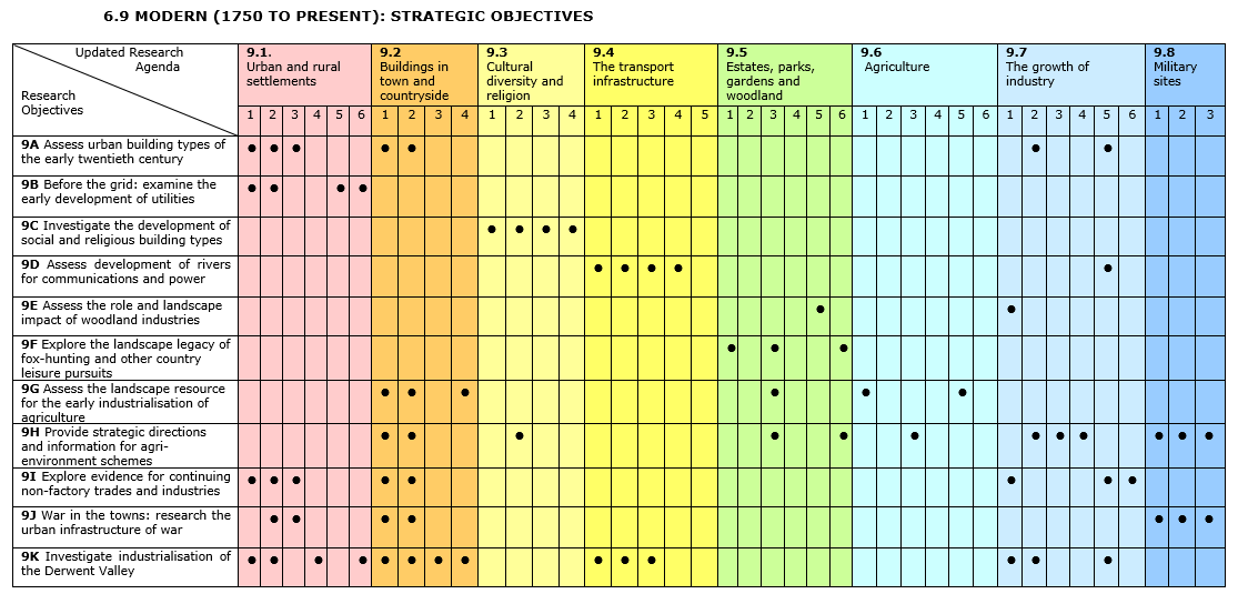
Assess urban building types of the early twentieth century
Summary:

The 1930s Douglas Garage at 46-50 Sheep Street, Northampton. Northamptonshire Archaeology 36, 165-167). This stylish, purpose-built garage was designed in Art Deco style by the Long Buckby architect Frank Cole and comprised a maintenance area, sale room and living accommodation above (photograph after 1953, from Douglas family collection; reproduced by permission of the Douglas family and Northamptonshire Archaeology)Conservation Area designations[1] go some way to protecting townscapes where there are coherent groups of buildings, but are less often applied to areas where the identity of buildings is not clear and where attrition has brought gaps and ‘unwelcome’ intrusions into the townscape[2]. As a result, some types of building – especially small-scale industrial buildings – are poorly protected, little understood or appreciated, and subject to continued threat by demolition. Typically, these occur in areas that were developed in the inter-war years and are now sandwiched between the nineteenth-century suburbs and the twentieth-century business park. These locales can also contain early industrial structures made from materials which, although mass-produced, nevertheless retain local distinctiveness. Examples include concrete walling, asbestos and tinplate roofing, together with steel roof trusses. These areas rarely form part of Conservation Areas and are generally subject to piecemeal redevelopment. There is a need to review the industrial building types of these areas in order to establish effective continuing management regimes and to inform the Historic Area Appraisals which are now being advocated by English Heritage. The Research Objective could be extended to other types of twentieth century-building, such as public houses, banks, garages and schools, with the aim of identifying structures of intrinsic interest that might be vulnerable to demolition and ensuring appropriate recording and analysis of such buildings.
Agenda topics addressed: 9.1.1-9.1.3; 9.2.1; 9.2.2; 9.7.2; 9.7.5
Before the grid: examine the early development of utilities
Summary:

The industrialisation of town and country[3] and advances in public health and quality of life[4] were accelerated by the provision from the nineteenth century of piped water, gas, electricity and sewerage facilities. Several valuable reviews of this subject are available[5][6], including syntheses produced as part of the Monuments Protection Programme[7][8]. However, the massive scale of later provision has obliterated much early evidence, which it is suggested should be located and recorded to elucidate the earliest phases of development. Water was provided in the eighteenth century from wells, pumps, streams and ponds, sometimes via semi-culverted courses that may have served both people and animals, and piped water supplies and associated structures[9] only developed from the mid-nineteenth century, together with sewerage facilities. Local gasworks, which provided power principally for domestic and street lighting, emerged in towns from the 1820s, often close to the railway that brought the coal supplies. The major rivers of the East Midlands enabled large-scale production of electricity from the 1890s, augmented by electricity from gasworks; this provided power to urban areas, but many rural areas did not have electricity until the National Grid was established in 1947[10]. It is recommended that surviving physical evidence for the earlier phases of utility provision be identified and recorded in order to clarify the early history of utilities and to permit assessment of variations between town and country and across the region.
Agenda topics addressed: 9.1.1; 9.1.2; 9.1.5; 9.1.6
Investigate the development of social and religious building types
Summary:

Early Ordnance Survey maps of the East Midlands show large numbers and a high turnover of chapel buildings during the nineteenth and early twentieth centuries, particularly in the developing industrial settlements of areas such as the Nottinghamshire and Derbyshire coalfields[11]. Detailed survey and analysis of the many Methodist and other non-conformist chapels and meeting places that developed in towns and villages from the eighteenth century[12] would add usefully to our understanding not only of changing architectural styles but also the relationship of these buildings to the communities that they served and the impact of religious denominations upon settlement growth[13]. Survey could usefully be extended to associated cemeteries and to the wide variety of community and other social buildings that characterise these communities, including schools, miners’ baths, public houses, social clubs and cinemas[14]. Taking a broader perspective, this Research Objective could also be developed to consider the impact of ethnic groups upon the religious architecture of multicultural centres such as Nottingham, Leicester, Loughborough and Northampton[15].
Agenda topics addressed: 9.3.1-9.3.4
Investigate the use of rivers for transport and power and their relationship to other communications networks
Summary:

Industrial development during the eighteenth century led to the increased use of East Midlands rivers such as the Nene and the Trent for the transport of goods and for the generation of power[16], embracing thereby two functions which were not always compatible[17]. Early use of the minor rivers, such as the Derbyshire Wye, was succeeded from early in the eighteenth century by improvement works carried out on the Nene[18] and Trent[19]. In addition to documentary sources, archaeological evidence for navigation improvements and water management takes a surprising variety of forms, ranging from canal cuts and channels, flood-banks and spoil from river dredging, weirs, locks, wharves, sunken boats and boatyards to warehouses and bridges[20]. The rivers were important for moving and distributing not only the products of the extractive industries, especially coal and lead, but also the products of agriculture, such as grain and timber, and those of rural and urban industry, such as pottery, brick and tile. They were pivotal, therefore, to the industrialisation of the region. There is also considerable scope for investigating the relationship of river transport to other linear transport networks, including canals not forming parts of improved waterways, turnpike roads, horse-drawn tramways and, from the nineteenth century, the developing railways[21][22][23].
Agenda topics addressed: 9.4.1-9.4.4; 9.7.5
Assess the role and landscape impact of woodland industries
Summary:
A broad range of woodland industries, persisting as important components of the rural economy into the early twentieth century[24], may be deduced from documentary, ecological and archaeological sources. The field evidence includes woodland boundaries, engineered woodland tracks, pollarded and coppiced trees at production sites, sawmills at timber processing sites and the often small-scale industrial sites where the timber products were used[25][26]. Demand shifted during the course of the period away from the substantial oak timbers that were needed up to around 1850 for building and shipbuilding towards light wood and timber products. Particularly close links may be demonstrated from the 1780s with the developing leather industry, which relied upon oak bark for tanning, obtained principally from sources in Rockingham and Sherwood Forests[27]. Strong local traditions may be demonstrated, as exemplified by a focus upon willow basket and container manufacture in the Trent valley[28]. There is significant scope for elucidating further these traditions, and for clarifying by further field survey woodland management practices and the distribution of saw mills, wood yards and other physical traces of woodland industries such as charcoal and white-coal (kiln-dried wood) production[29]. Important features may survive in woodland not yet surveyed in detail and in other landscapes comparatively unscathed by later developments (especially the parklands attached to large country houses such as Chatsworth and Castle Ashby[30]).
Agenda topics addressed: 9.5.5; 9.7.1
Explore the landscape legacy of fox-hunting and other rural leisure pursuits
Summary:


Grouse-shooting butts on Big Moor, Derbyshire. Most are characterised by a distinctive penannular earthwork: (top: entrance marked by ranging rod, on the side opposite the direction of fire) but some are constructed of stone (bottom: built into a Bronze Age burial cairn; photographs: D. Knight)
The increasingly efficient and productive agricultural landscape of the nineteenth century also provided the locale for fox-hunting and other leisure pursuits, although the history of investigation has tended to focus on the contemporary agricultural use of the countryside[31]. Finch has drawn attention to the ways in which fox-hunting influenced the construction of the nineteenth-century landscape, leading to the establishment of coverts of low scrub cover, modifications to hedges and the development of kennels for hounds[32]. Today, the over-grown fox coverts constitute an important historic woodland resource that is largely neglected by Historic Environment Records[33]. Further research is needed into the history of establishment of the coverts, the uses to which they were put, and the ecological and landscape resource that they now offer. Ancillary research into the landscape and social history of fox-hunting and other contemporary sports such as duck and game shooting would allow the identification of associated small and large-scale landscape features such as fowling decoys and shooting butts[34]. The latter are particularly characteristic of upland Derbyshire, where alignments of earthen and stone-built grouse-shooting butts and cabins providing shelter and storage for shooting parties are scattered widely over the gritstone moorlands[35].
Agenda topics addressed: 9.5.1; 9.5.3; 9.5.6
Assess the landscape impact of the early industrialisation of agriculture
Summary:

There has been little research into the physical impact of the early industrialisation of agriculture, which took place at a much slower rate than in industry[36][37]. During the nineteenth century, horse gins in distinctive housings powered mills to produce food for horses and livestock, while from the second half of the nineteenth century arable agriculture was revolutionised by steam ploughing. The latter entailed the use of wide, straight headlands for traversing by engine, and created a distinctive pattern of straight ridge-and-furrow contrasting with the wider, sinuous features that characterise relics of the medieval open-field system[38]. Because of the cost and complexity of the process, steam ploughing was often undertaken by contractors. However, the advent of paraffin and diesel-engined tractors after World War I brought mechanisation on a large scale, and with it engine sheds and fuel tanks in place of stables and fodder stores. The internal combustion engine also allowed dairying to be industrialised, and from early in the twentieth century new milking parlours were built and fitted with oil-engined milking machines. All these features of a nascent period of agricultural development are increasingly disappearing with no record, while those that have survived the modernisation of the later twentieth century are being removed during the conversion of farms into house complexes. Such trends emphasise the importance of instigating a systematic regional survey of this dwindling evidence for the landscape impact of the early industrialisation of the farming economy.
Agenda topics addressed: 9.2.1; 9.2.2; 9.2.4; 9.5.3; 9.6.1; 9.7.2
Characterising the rural environment: identify and record historic buildings and landscape features
Summary:

Although agri-environment schemes have for many years paid attention to archaeological features, they have been much less concerned with agricultural impacts on land-holdings in general and with minor buildings and historic landscape features[39]. Many of the latter, such as roadside horse troughs, milk churn stands and the vitally important dew ponds of upland Derbyshire, may elude Historic Environment Records, and may be lost without record as a consequence of agricultural improvements or other developments. There is a pressing need, therefore, to develop a strategy to identify and safeguard the range of features that might be anticipated in rural contexts and to quantify the anticipated variability between geological and topographic zones[40]. This could usefully accompany an extension of vernacular buildings surveys, carried out to the level recommended by the Society for the Protection of Ancient Buildings (SPAB) and including farmhouses, estate buildings, barns and other specialist agricultural buildings[41]. Coverage of the vernacular building resource is sporadic across the region and the level of detail is variable. Some areas have a high level of baseline coverage but few detailed recordings – for example in Nottinghamshire, where SPAB-compliant surveys have been carried out for around only 15% of historic farmsteads[42]. This limits assessment of architectural details and local distinctiveness (for example in barn ventilation slot arrangements, types of roof structure and the internal configurations of farm buildings) and hence studies of historic landscape character.
Agenda topics addressed: 9.2.1; 9.2.2; 9.3.2; 9.5.3; 9.5.6; 9.6.3; 9.7.2-9.7.4; 9.8.1-9.8.3
Explore the evidence for continuing non-factory trades and industries
Summary:

The pace of industrialisation in the East Midlands varied considerably from one industry to another, with the early application of water-power to textile spinning contrasting with the long-lasting small scale of industries such as hosiery and boot and shoe manufacture[43][44]. Framework knitting outworking in houses and workshops continued into the later nineteenth century in areas of Derbyshire, Leicestershire and Nottinghamshire[45]. Boot and shoe manufacture continued under a similar outworking system over much the same period, and was especially important in Leicestershire and Northamptonshire[46][47]. There is a need for further scrutiny through a variety of techniques of the methods of the small-scale industries. Archaeology can illuminate the scale and use of buildings and associated rubbish deposits, economic and demographic factors, and the topographical context, but input is also required from economic historians and geographers when examining many aspects of more recent archaeology. Building analysis can also provide insights into the arrangement of industrial and domestic functions and hence contribute to a more detailed understanding of social heritage.
Agenda topics addressed: 9.1.1-9.1.3; 9.2.1; 9.2.2; 9.7.1; 9.7.5; 9.7.6
War in the towns: research the urban infrastructure of war
Summary:

The East Midlands preserves an extensive range of remains dating from World Wars I and II and the Cold War, including airfields, pill boxes, communal bunkers, anti-aircraft batteries and searchlight emplacements[48]. These have attracted significant survey and recording in recent years[49][50][51], but the urban infrastructure of war is much less well-researched and significantly less well-known. Unglamorous buildings and developments such as barracks and drill halls, factory extensions and storage depots, often on the urban fringe, are all in need of recording, the more so because construction plans and other information are often not available. All are vulnerable to redevelopment, and recording would contribute valuable data to the Historic Environment Records that underpin the planning system and assist future academic enquiry.

The foundations of a probable water tower, placed near the fence demarcating a prisoner-of-war camp constructed in Wollaton Park, Nottingham, during the Second World War (photograph: Lee Elliott)
Agenda topics addressed: 9.1.2; 9.1.3; 9.2.1; 9.2.2; 9.8.1-9.8.3
Investigate further the industrialisation of the Derwent Valley
Summary:
A string of cotton mills was established in the eighteenth century along 24km of the Derwent Valley between Matlock and Derby, each of which was larger in scale, output and labour force than any earlier industrial undertaking[52]. The change from water to steam power in the nineteenth century caused the foci of industry to shift elsewhere, with the result that many mill buildings, associated workers’ houses, canals, dismantled tramway lines and other landscape features, such as quarries for the manufacture of millstones and grindstones, have survived. This area is of critical importance to the development of the industrial revolution, as recognised by its designation in 2001 as a World Heritage Site, and preserves a complex of mills and associated remains of international importance. Valuable surveys have been completed of individual mills and ancillary structures[53], while Conservation Area status has contributed to the protection of individual structures, but the area would benefit from continued investment in public information and interpretation facilities and further research into the origins and development of the textile industry. In addition to the need to make more information generally available, historic landscape features relating to the infrastructure of industry and the supporting agricultural landscape should be assessed for their potential to illuminate the context of the industrialisation of the textile industry[54].
Agenda topics addressed: 9.1.1; 9.1.2; 9.1.4; 9.1.6; 9.2.1-9.2.4; 9.4.1-9.4.3; 9.7.1; 9.7.2; 9.7.5
| 9A | 9B | 9C | 99D /td> | 9E | 9F | 9G | 9H | 9I | 9J | 9K |
Assess urban building types of the early twentieth century
Summary:
The 1930s Douglas Garage at 46-50 Sheep Street, Northampton. Northamptonshire Archaeology 36, 165-167). This stylish, purpose-built garage was designed in Art Deco style by the Long Buckby architect Frank Cole and comprised a maintenance area, sale room and living accommodation above (photograph after 1953, from Douglas family collection; reproduced by permission of the Douglas family and Northamptonshire Archaeology)Conservation Area designations[1] go some way to protecting townscapes where there are coherent groups of buildings, but are less often applied to areas where the identity of buildings is not clear and where attrition has brought gaps and ‘unwelcome’ intrusions into the townscape[2]. As a result, some types of building – especially small-scale industrial buildings – are poorly protected, little understood or appreciated, and subject to continued threat by demolition. Typically, these occur in areas that were developed in the inter-war years and are now sandwiched between the nineteenth-century suburbs and the twentieth-century business park. These locales can also contain early industrial structures made from materials which, although mass-produced, nevertheless retain local distinctiveness. Examples include concrete walling, asbestos and tinplate roofing, together with steel roof trusses. These areas rarely form part of Conservation Areas and are generally subject to piecemeal redevelopment. There is a need to review the industrial building types of these areas in order to establish effective continuing management regimes and to inform the Historic Area Appraisals which are now being advocated by English Heritage. The Research Objective could be extended to other types of twentieth century-building, such as public houses, banks, garages and schools, with the aim of identifying structures of intrinsic interest that might be vulnerable to demolition and ensuring appropriate recording and analysis of such buildings.
Agenda topics addressed: 9.1.1-9.1.3; 9.2.1; 9.2.2; 9.7.2; 9.7.5
Archaeology of the East Midlands: 242, 257
Other research frameworks:
EH Thematic Research Strategy for the Urban Historic Environment 2010: Priorities UR4 (The twentieth century) and UR9 (Threatened or vulnerable building types)
EH Thematic Research Strategy for the Historic Industrial Environment 2010: Priority IND5 (Impact of industrialisation: Understanding industrial buildings and sites)
References:
[1] http://www.english-heritage.org.uk/caring/listing/local/conservation-areas/
[2] For the conservation context of modern buildings see Campion, G 2006 ‘The Modern period’ in The Archaeology of the East Midlands, 238-239; for recommendations regarding buildings generally, see Campion 2006, 242-243
Before the grid: examine the early development of utilities
Summary:
The industrialisation of town and country[3] and advances in public health and quality of life[4] were accelerated by the provision from the nineteenth century of piped water, gas, electricity and sewerage facilities. Several valuable reviews of this subject are available[5][6], including syntheses produced as part of the Monuments Protection Programme[7][8]. However, the massive scale of later provision has obliterated much early evidence, which it is suggested should be located and recorded to elucidate the earliest phases of development. Water was provided in the eighteenth century from wells, pumps, streams and ponds, sometimes via semi-culverted courses that may have served both people and animals, and piped water supplies and associated structures[9] only developed from the mid-nineteenth century, together with sewerage facilities. Local gasworks, which provided power principally for domestic and street lighting, emerged in towns from the 1820s, often close to the railway that brought the coal supplies. The major rivers of the East Midlands enabled large-scale production of electricity from the 1890s, augmented by electricity from gasworks; this provided power to urban areas, but many rural areas did not have electricity until the National Grid was established in 1947[10]. It is recommended that surviving physical evidence for the earlier phases of utility provision be identified and recorded in order to clarify the early history of utilities and to permit assessment of variations between town and country and across the region.
Agenda topics addressed: 9.1.1; 9.1.2; 9.1.5; 9.1.6
Archaeology of the East Midlands: 244, 257
Other research frameworks:
EH Thematic Research Strategy for the Historic Industrial Environment 2010: Priority IND4 (The impact of industrialisation: transport systems, communications and public utilities)
References:
[3] Beckett, J V 1988 The East Midlands from AD 1000. London: Longman, 274-298
[4] Beckett 1988, 244-246
[5] Palmer, M and Neaverson, P 1992 Industrial Landscapes of the East Midlands. Chichester: Phillimore
[6] Cossons, N 1993 The BP Book of Industrial Archaeology, 3 edn. Newton Abbott: David & Charles, 215-234
[7] Schofield, J 2000 MPP 2000: A Review of the Monuments Protection Programme, 1986-2000. London: English Heritage.
[8] eg Trueman, M 1995 MPP: Electric Power Generation. Step 3 Report. London: English Heritage; Trueman, M 2000 MPP: Water and Sewage Industries. Step 3 Report. London: English Heritage; Trueman, M 2002 MPP: Gas Industry. Step 3 Report. London: English Heritage
[9] eg pumping stations; notably at Bestwood and Papplewick, Nottinghamshire: Palmer and Neaverson 1992, 111
[10] Campion, G 2006 ‘The Modern period’ in The Archaeology of the East Midlands, 244
Investigate the development of social and religious building types
Summary:
Early Ordnance Survey maps of the East Midlands show large numbers and a high turnover of chapel buildings during the nineteenth and early twentieth centuries, particularly in the developing industrial settlements of areas such as the Nottinghamshire and Derbyshire coalfields[11]. Detailed survey and analysis of the many Methodist and other non-conformist chapels and meeting places that developed in towns and villages from the eighteenth century[12] would add usefully to our understanding not only of changing architectural styles but also the relationship of these buildings to the communities that they served and the impact of religious denominations upon settlement growth[13]. Survey could usefully be extended to associated cemeteries and to the wide variety of community and other social buildings that characterise these communities, including schools, miners’ baths, public houses, social clubs and cinemas[14]. Taking a broader perspective, this Research Objective could also be developed to consider the impact of ethnic groups upon the religious architecture of multicultural centres such as Nottingham, Leicester, Loughborough and Northampton[15].
Agenda topics addressed: 9.3.1-9.3.4
Archaeology of the East Midlands: 243, 257
Other research frameworks:
EH Thematic Research Strategy for the Urban Historic Environment 2010: Priorities UR4 (The twentieth century), UR5 (Parks, open spaces and cemeteries) and UR9 (Threatened and vulnerable building types)
References:
[11] Beckett, J V 1988. The East Midlands from AD 1000. London: Longman, 256-259
[12] Developing from recent surveys of non-conformist chapels and meeting places: Stell, C 1986 Nonconformist Chapels and Meeting Houses in Central England. London: RCHME (including chapels in the historic counties of Derbyshire, Leicestershire, Northamptonshire, Nottinghamshire and Rutland); Stell, C 2001 Nonconformist Chapels and Meeting Houses in Eastern England. London: English Heritage (including chapels in the historic county of Lincolnshire)
[13] Campion, G 2006 ‘The Modern period’ in The Archaeology of the East Midlands, 243
[14] Beckett 1988, 249-256; eg the pioneering school buildings of George Widdows, appointed architect to Derbyshire County Council in 1910: http://www.c20society.org.uk/botm/ilkeston-school-derbyshire/
[15] Campion 2006, 242
Investigate the use of rivers for transport and power and their relationship to other communications networks
Summary:
Industrial development during the eighteenth century led to the increased use of East Midlands rivers such as the Nene and the Trent for the transport of goods and for the generation of power[16], embracing thereby two functions which were not always compatible[17]. Early use of the minor rivers, such as the Derbyshire Wye, was succeeded from early in the eighteenth century by improvement works carried out on the Nene[18] and Trent[19]. In addition to documentary sources, archaeological evidence for navigation improvements and water management takes a surprising variety of forms, ranging from canal cuts and channels, flood-banks and spoil from river dredging, weirs, locks, wharves, sunken boats and boatyards to warehouses and bridges[20]. The rivers were important for moving and distributing not only the products of the extractive industries, especially coal and lead, but also the products of agriculture, such as grain and timber, and those of rural and urban industry, such as pottery, brick and tile. They were pivotal, therefore, to the industrialisation of the region. There is also considerable scope for investigating the relationship of river transport to other linear transport networks, including canals not forming parts of improved waterways, turnpike roads, horse-drawn tramways and, from the nineteenth century, the developing railways[21][22][23].
Agenda topics addressed: 9.4.1-9.4.4; 9.7.5
Archaeology of the East Midlands: 234, 257
Other research frameworks:
EH Thematic Research Strategy for the Historic Industrial Environment 2010: Priority IND4 (The impact of industrialisation: transport systems, communications and public utilities)
References:
[16] eg Derwent and Wye Valleys: see Objective 9K
[17] Courtney, P 2006 ‘The Post-Medieval period’ in The Archaeology of the East Midlands, 229
[18] Alsop, J D 1986 ‘The development of inland navigation on the River Nene in the early eighteenth century’. Northamptonshire Past and Present 7, 161-163
[19] Wood, A C 1950 ‘The history of trade and transport on the River Trent’. Transactions of the Thoroton Society 54, 1-44
[20] Hudson, K 1966 Industrial Archaeology: An Introduction. London: John Baker, 126-132
[21] Beckett, J V 1988 The East Midlands from AD 1000. London: Longman, 260-274, 327-330
[22] Palmer, M and Neaverson, P 1992 Industrial Landscapes of the East Midlands. Chichester: Phillimore
[23] Leleux, R 1984 A Regional History of the Railways of Great Britain: IX: The East Midlands, 2 edn. Newton Abbott: David & Charles
Assess the role and landscape impact of woodland industries
Summary:
A broad range of woodland industries, persisting as important components of the rural economy into the early twentieth century[24], may be deduced from documentary, ecological and archaeological sources. The field evidence includes woodland boundaries, engineered woodland tracks, pollarded and coppiced trees at production sites, sawmills at timber processing sites and the often small-scale industrial sites where the timber products were used[25][26]. Demand shifted during the course of the period away from the substantial oak timbers that were needed up to around 1850 for building and shipbuilding towards light wood and timber products. Particularly close links may be demonstrated from the 1780s with the developing leather industry, which relied upon oak bark for tanning, obtained principally from sources in Rockingham and Sherwood Forests[27]. Strong local traditions may be demonstrated, as exemplified by a focus upon willow basket and container manufacture in the Trent valley[28]. There is significant scope for elucidating further these traditions, and for clarifying by further field survey woodland management practices and the distribution of saw mills, wood yards and other physical traces of woodland industries such as charcoal and white-coal (kiln-dried wood) production[29]. Important features may survive in woodland not yet surveyed in detail and in other landscapes comparatively unscathed by later developments (especially the parklands attached to large country houses such as Chatsworth and Castle Ashby[30]).
Agenda topics addressed: 9.5.5; 9.7.1
Archaeology of the East Midlands: 246, 257
Other research frameworks: EH Thematic Research Strategy for the Historic Industrial Environment 2010: Priorities IND 3 and 5 (Impact of industrialisation: industrial landscapes; Understanding industrial buildings and sites)
References:
[24] Campion, G 2006 ‘The Modern period’ in The Archaeology of the East Midlands, 246
[25] Watkins, C 1990 Woodland Management and Conservation. Newton Abbot: David & Charles, 39-55
[26] Rackham, O 1987 The History of the English Countryside. London: Dent, 62-118
[27] Campion 2006, 246
[28] Cousins, R 2007 A Basketful: Willow Growing and Basketmaking in Nottinghamshire and Lincolnshire. Nottingham: Nottinghamshire County Council and Heritage Lincolnshire
[29] Crossley, D 1990 Post-Medieval Archaeology in Britain. Leicester: Leicester University Press, 22-24, 189-191
[30] Barnett, J and Williamson, T 2005 Chatsworth: A Landscape History. Macclesfield: Windgather Press; Barnatt, J and Bannister, N 2009 The Archaeology of a Great Estate: Chatsworth and Beyond. Macclesfield: Windgather Press; Campion 2006, 246
Explore the landscape legacy of fox-hunting and other rural leisure pursuits
Summary:
Grouse-shooting butts on Big Moor, Derbyshire. Most are characterised by a distinctive penannular earthwork: (top: entrance marked by ranging rod, on the side opposite the direction of fire) but some are constructed of stone (bottom: built into a Bronze Age burial cairn; photographs: D. Knight)
The increasingly efficient and productive agricultural landscape of the nineteenth century also provided the locale for fox-hunting and other leisure pursuits, although the history of investigation has tended to focus on the contemporary agricultural use of the countryside[31]. Finch has drawn attention to the ways in which fox-hunting influenced the construction of the nineteenth-century landscape, leading to the establishment of coverts of low scrub cover, modifications to hedges and the development of kennels for hounds[32]. Today, the over-grown fox coverts constitute an important historic woodland resource that is largely neglected by Historic Environment Records[33]. Further research is needed into the history of establishment of the coverts, the uses to which they were put, and the ecological and landscape resource that they now offer. Ancillary research into the landscape and social history of fox-hunting and other contemporary sports such as duck and game shooting would allow the identification of associated small and large-scale landscape features such as fowling decoys and shooting butts[34]. The latter are particularly characteristic of upland Derbyshire, where alignments of earthen and stone-built grouse-shooting butts and cabins providing shelter and storage for shooting parties are scattered widely over the gritstone moorlands[35].
Agenda topics addressed: 9.5.1; 9.5.3; 9.5.6
Archaeology of the East Midlands: 246, 257
References:
[31] Campion, G 2006 ‘The Modern period’ in The Archaeology of the East Midlands, 246
[32] Finch, J 2004 ‘Grass, grass, grass: Fox-hunting and the creation of the modern landscape’. Landscapes 5, 41-52
[33] Finch, J 2007 ‘Wider famed countries: Historic landscape characterisation in the Midland shires’. Landscapes 8, 50-63
[34] Jones, E L 2009 ‘The environmental effects of blood sports in lowland England since 1750’. Rural History, Culture and Society 20, 51-66
[#35] Bevan, B 2004 The Upper Derwent. 10,000 Years in a Peak District Valley. Stroud: Tempus, 126-129
Assess the landscape impact of the early industrialisation of agriculture
Summary:
There has been little research into the physical impact of the early industrialisation of agriculture, which took place at a much slower rate than in industry[36][37]. During the nineteenth century, horse gins in distinctive housings powered mills to produce food for horses and livestock, while from the second half of the nineteenth century arable agriculture was revolutionised by steam ploughing. The latter entailed the use of wide, straight headlands for traversing by engine, and created a distinctive pattern of straight ridge-and-furrow contrasting with the wider, sinuous features that characterise relics of the medieval open-field system[38]. Because of the cost and complexity of the process, steam ploughing was often undertaken by contractors. However, the advent of paraffin and diesel-engined tractors after World War I brought mechanisation on a large scale, and with it engine sheds and fuel tanks in place of stables and fodder stores. The internal combustion engine also allowed dairying to be industrialised, and from early in the twentieth century new milking parlours were built and fitted with oil-engined milking machines. All these features of a nascent period of agricultural development are increasingly disappearing with no record, while those that have survived the modernisation of the later twentieth century are being removed during the conversion of farms into house complexes. Such trends emphasise the importance of instigating a systematic regional survey of this dwindling evidence for the landscape impact of the early industrialisation of the farming economy.
Agenda topics addressed: 9.2.1; 9.2.2; 9.2.4; 9.5.3; 9.6.1; 9.7.2
Archaeology of the East Midlands: 247, 257
References:
[36] Campion, G 2006 ‘The Modern Period’ in The Archaeology of the East Midlands, 246-247
[37] Beckett, J V 1988 The East Midlands from AD 1000. London: Longman, 200-208
[38] Haining, J and Tyler, C 1970 Ploughing By Steam. Bath: Ashgrove Press, 96-117; Bowen, H C 1961 Ancient Fields. London: Cobbett, 46-50; Anderton, M and Went, D 2002 ‘Turning the plough: Loss of a landscape legacy’. English Heritage Conservation Bulletin 42, 52-55
Characterising the rural environment: identify and record historic buildings and landscape features
Summary:
Although agri-environment schemes have for many years paid attention to archaeological features, they have been much less concerned with agricultural impacts on land-holdings in general and with minor buildings and historic landscape features[39]. Many of the latter, such as roadside horse troughs, milk churn stands and the vitally important dew ponds of upland Derbyshire, may elude Historic Environment Records, and may be lost without record as a consequence of agricultural improvements or other developments. There is a pressing need, therefore, to develop a strategy to identify and safeguard the range of features that might be anticipated in rural contexts and to quantify the anticipated variability between geological and topographic zones[40]. This could usefully accompany an extension of vernacular buildings surveys, carried out to the level recommended by the Society for the Protection of Ancient Buildings (SPAB) and including farmhouses, estate buildings, barns and other specialist agricultural buildings[41]. Coverage of the vernacular building resource is sporadic across the region and the level of detail is variable. Some areas have a high level of baseline coverage but few detailed recordings – for example in Nottinghamshire, where SPAB-compliant surveys have been carried out for around only 15% of historic farmsteads[42]. This limits assessment of architectural details and local distinctiveness (for example in barn ventilation slot arrangements, types of roof structure and the internal configurations of farm buildings) and hence studies of historic landscape character.
Agenda topics addressed: 9.2.1; 9.2.2; 9.3.2; 9.5.3; 9.5.6; 9.6.3; 9.7.2-9.7.4; 9.8.1-9.8.3
Archaeology of the East Midlands: 247
References:
[39] Knight, B 2007 ‘Rural Development Agencies and rural heritage’. English Heritage Conservation Bulletin 54, 29-31
[40] Campion, G 2006 ‘The Modern period’ in The Archaeology of the East Midlands, 246-247
[41] Campion 2006, 247; Oxley, R 2010 Survey and Repair of Traditional Buildings. Shaftesbury: Donhead
[42] Nottinghamshire County Council Historic Environment Records; source: J. Mordan
Explore the evidence for continuing non-factory trades and industries
Summary:
The pace of industrialisation in the East Midlands varied considerably from one industry to another, with the early application of water-power to textile spinning contrasting with the long-lasting small scale of industries such as hosiery and boot and shoe manufacture[43][44]. Framework knitting outworking in houses and workshops continued into the later nineteenth century in areas of Derbyshire, Leicestershire and Nottinghamshire[45]. Boot and shoe manufacture continued under a similar outworking system over much the same period, and was especially important in Leicestershire and Northamptonshire[46][47]. There is a need for further scrutiny through a variety of techniques of the methods of the small-scale industries. Archaeology can illuminate the scale and use of buildings and associated rubbish deposits, economic and demographic factors, and the topographical context, but input is also required from economic historians and geographers when examining many aspects of more recent archaeology. Building analysis can also provide insights into the arrangement of industrial and domestic functions and hence contribute to a more detailed understanding of social heritage.
Agenda topics addressed: 9.1.1-9.1.3; 9.2.1; 9.2.2; 9.7.1; 9.7.5; 9.7.6
Archaeology of the East Midlands: 251-253, 257
Other research frameworks:
EH Thematic Research Strategy for the Historic Industrial Environment 2010: Priorities IND 3 and 5 (Impact of industrialisation: industrial landscapes; Understanding industrial buildings and sites)
References:
[43] Campion, G 2006 ‘The Modern period’ in The Archaeology of the East Midlands, 251-253
[44] Beckett, J V 1988 The East Midlands from AD 1000. London: Longman
[45] Chapman, S D 2002 ‘Hosiery and knitwear: Four centuries of small-scale industry in Britain c.1589-2000’. Pasold Studies in Textile History 12.
[46] Stocker, D A 2006 England’s Landscape: The East Midlands. London: Collins, 164-165
[47] Campion, G 2001 ‘People, process, power and place: An archaeology of control in East Midlands outworking 1820-1900’ in Palmer, M and Neaverson, P (eds) From Industrial Revolution to Consumer Revolution: International Perspectives on the Archaeology of Industrialisation. Papers of the International Committee for the Conservation of the Industrial Heritage 2000 Congress, 75-84
War in the towns: research the urban infrastructure of war
Summary:
The East Midlands preserves an extensive range of remains dating from World Wars I and II and the Cold War, including airfields, pill boxes, communal bunkers, anti-aircraft batteries and searchlight emplacements[48]. These have attracted significant survey and recording in recent years[49][50][51], but the urban infrastructure of war is much less well-researched and significantly less well-known. Unglamorous buildings and developments such as barracks and drill halls, factory extensions and storage depots, often on the urban fringe, are all in need of recording, the more so because construction plans and other information are often not available. All are vulnerable to redevelopment, and recording would contribute valuable data to the Historic Environment Records that underpin the planning system and assist future academic enquiry.
Agenda topics addressed: 9.1.2; 9.1.3; 9.2.1; 9.2.2; 9.8.1-9.8.3
Archaeology of the East Midlands: 256-257
Other research frameworks:
Schofield, J 2004 Modern Military Matters. Studying and managing the twentieth century defence heritage in Britain: a discussion document. York: Council for British Archaeology (Research Theme A4: Civil infrastructure)
EH Thematic Research Strategy for the Urban Historic Environment 2010: Priority UR4 (The twentieth century)
References:
[48] Campion, G 2006 ‘The Modern period’ in The Archaeology of the East Midlands, 254-257
[49] See papers in English Heritage’s Conservation Bulletin 44, 2003: The Archaeology of Conflict.
[50] Brown, I, Burridge, D, Clark, D et al 1995 Twentieth Century Defences in Britain: An Introductory Guide (CBA Practical Handbooks in Archaeology 12). York: Council for British Archaeology
[51] Schofield, J 2004 Modern Military Matters. Studying and managing the twentieth century defence heritage in Britain: A discussion document. York: Council for British Archaeology
Investigate further the industrialisation of the Derwent Valley
Summary:
A string of cotton mills was established in the eighteenth century along 24km of the Derwent Valley between Matlock and Derby, each of which was larger in scale, output and labour force than any earlier industrial undertaking[52]. The change from water to steam power in the nineteenth century caused the foci of industry to shift elsewhere, with the result that many mill buildings, associated workers’ houses, canals, dismantled tramway lines and other landscape features, such as quarries for the manufacture of millstones and grindstones, have survived. This area is of critical importance to the development of the industrial revolution, as recognised by its designation in 2001 as a World Heritage Site, and preserves a complex of mills and associated remains of international importance. Valuable surveys have been completed of individual mills and ancillary structures[53], while Conservation Area status has contributed to the protection of individual structures, but the area would benefit from continued investment in public information and interpretation facilities and further research into the origins and development of the textile industry. In addition to the need to make more information generally available, historic landscape features relating to the infrastructure of industry and the supporting agricultural landscape should be assessed for their potential to illuminate the context of the industrialisation of the textile industry[54].
Agenda topics addressed: 9.1.1; 9.1.2; 9.1.4; 9.1.6; 9.2.1-9.2.4; 9.4.1-9.4.3; 9.7.1; 9.7.2; 9.7.5
Archaeology of the East Midlands: 251, 257
Other research frameworks:
EH Thematic Research Strategy for the Historic Industrial Environment 2010: Priorities IND 3, 4 and 5 (Impact of industrialisation: industrial landscapes; Transport systems, communications and public utilities; Understanding industrial buildings and sites)
References:
[52] Cooper, B 1983 Transformation of a Valley. The Derbyshire Derwent. London: Heinemann; Derwent Valley Mills Partnership 2011 The Derwent Abbey Mills and Their Communities. Matlock: Derwent Valley Mills Partnership; Menuge, A 1993 ‘The cotton mills of the Derbyshire Derwent and its tributaries’. Industrial Archaeology Review 16, 38-61
[53] eg Menuge, A 2006 Boars Head Mills, Darley Abbey, Derby: A Survey and Investigation of the Cotton Mills and Ancillary Buildings (English Heritage Research Department Report Series 35/2006). English Heritage
[54] Compare Alfrey, J and Clark, C 1993 The Landscape of Industry: Patterns of Change in the Ironbridge Gorge. London: Routledge


Left image: Belper, Derbyshire: the brick-built East Mill with square corner towers, built in 1912, abuts the T-shaped five-storey North Mill, built by William Strutt in 1804 (right of image). The latter is a very early example of a fire-proofed mill, with cast iron framing and arched brick ceilings (photograph: D. Knight). Right image: Boars Head Mills, Darley Abbey, Derby, founded by Walter Evans in 1783, viewed from near the area of purpose-built workers` housing constructed in the early 19th century on the west bank of the Derwent. The five-storey brick building with segment-headed windows that can be seen in the background represents the earliest surviving cotton mill, constructed between 1789 and 1792 (photograph: D. Knight)