Click here to see how to contribute

Compile database of scientific dates and extend application of Bayesian modelling for radiocarbon dating
Summary:

Reviews of radiocarbon dates for the Neolithic and Bronze Age have been prepared for some areas of the East Midlands[1], but there is a pressing need for an up-to-date database for the entire region that could be employed as a springboard for prioritised dating programmes. These should take full account of progress in Bayesian modelling, which rests upon the acquisition of multiple radiocarbon dates and their analysis in the context of the excavated evidence[2]. Existing archives should be reviewed to identify those most likely to contain data appropriate for Bayesian analysis. These techniques offer exciting new opportunities to refine the chronology of excavated sites and to provide reliable cross-referencing to dated sites from elsewhere in the country[3]. The method is particularly useful for periods such as the earlier Neolithic, which offers complex monument sequences and lengthy phases of conservatism in the manufacture of ceramic and lithic items, and could usefully be applied to such poorly dated monuments as the chambered and long cairns of the Peak District[4]. Successful applications of the technique in the East Midlands include a Neolithic funerary cairn at Whitwell, allowing it to be placed firmly within the continuum occupied by the Cotswold-Severn chambered tombs[5], burnt mounds at Willington[6] and the Raunds monument complex[7].
Agenda topics addressed: 3.1.1-3.1.4; 3.3.1-3.3.4; 3.5.2; 3.5.3; 3.6.1; 3.7.1; 3.7.2
Assess the fieldwalking resource
Summary:
There is a long tradition of fieldwalking across the region, but there has been comparatively little synthesis at the regional scale of the results of these surveys. Some of this information has been published[8] but most resides in museum collections or in Historic Environment Records. In neither case is the detail of the information always readily accessible. A review of the results of fieldwalking surveys is recommended as a means of highlighting intra-regional contrasts in the spatial distribution of artefacts, combined with further study of museum collections[9]. Such work may contribute in turn to the development of future programmes of investigation. In Leicestershire and northern Northamptonshire, for example, lithic scatters indicate activity areas, many of them in clayland environments, at slightly lower elevations than Mesolithic lithic scatters but at much the same distance from water sources[10][11]. In contrast, surveys in Derbyshire on the uplands and in some valley locations indicate a close correlation between the locations of earlier Neolithic and later Mesolithic lithic scatters[12]. Debate continues on the interpretation of artefact distribution patterns, but the potential of fieldwalking for developing our understanding of early settlement is illustrated by a number of intra-regional synthetic studies[13] and by excavations of several scatters recorded during fieldwalking. These include Rothley, Leicestershire, where excavations of a clayland lithic scatter revealed domestic activity associated with Peterborough ware, Grooved Ware and an unusual carved stone plaque[14], and Mount Pleasant, Kenslow, Derbyshire, where excavations of several lithic clusters revealed a group of four small pits and Grimston, Peterborough and Grooved Ware deriving probably from separate phases of occupation[15]. Close analysis of fieldwalking assemblages should, therefore, enable excavation of finds scatters to be better targeted[16].
Agenda topics addressed: 3.1.3; 3.2.1; 3.2.2; 3.3.1; 3.4.1; 3.4.3; 3.5.2; 3.5.4; 3.6.4; 3.8.1; 3.9.1
Develop fieldwalking strategies and guidelines for landscape zones
Summary:
Synthesis of the results of fieldwalking (3B) should enable the development of more refined strategies for locating and interpreting the lithic scatters that provide crucial evidence for early prehistoric activity. There is a pressing need to investigate further the lithic signatures of monument types, as this may assist the interpretation of finds scatters. In addition, building upon projects in areas such as the Fens[17], the Nene and Ouse catchments around Raunds[18] and the Peak District[19], and upon smaller-scale surveys such as Elmton in Derbyshire[20], it would be useful if further surveys could be conducted across a wide spectrum of landscape zones. This would permit a more informed assessment of variations in the density and character of settlement and comparison of the lithic evidence with earthwork, cropmark and other remote sensing data across a wide range of geological and topographic zones[21]. It should also provide a secure foundation for the development of guidelines specific to particular landscape zones and aid identification of methodologies capable of detecting sites that are not easily located[22]. A review of the excavation record may also illuminate the nature of lithic assemblages recovered by fieldwalking[23].
Agenda topics addressed: 3.2.1; 3.2.2; 3.4.1; 3.4.3; 3.5.4; 3.6.4; 3.8.1
Assess the regional air photographic and lidar resource
Summary:

Many of Britain’s principal Neolithic and earlier Bronze Age monuments, which in the East Midlands include round and long earthen barrows or cairns[24][25][26], funerary enclosures[27], henges, timber or stone circles[28], cursus monuments[29] and causewayed enclosures[30], may be distinguished from the air by merit of their highly distinctive morphology[31]. Significant parts of the region are characterised by pasture or woodland, or are otherwise unsuited to cropmark formation on account of the underlying geology or the presence of masking deposits such as alluvium, colluvium or coversands. With this proviso, however, and with reference to English Heritage’s National Mapping Programme, review of the region’s air photographic resource should permit identification of many of the principal monument complexes, confirmation of their landscape settings and an initial indication of the range of components (Objective 3F]). Significantly, all but one of the eight known Neolithic causewayed enclosures in the region have been revealed by air photography[32], emphasising the effectiveness of this approach. The contribution of lidar, which may identify monuments preserved in pasture or concealed in dense woodland, bracken or heather[33], and of other airborne remote sensing methods[34] should also be considered.
Agenda topics addressed: 3.3.4; 3.4.1-3.4.3; 3.6.1-3.6.3; 3.7.2; 3.7.3; 3.8.1
Target sites with Late Mesolithic and Early Neolithic organic remains
Summary:

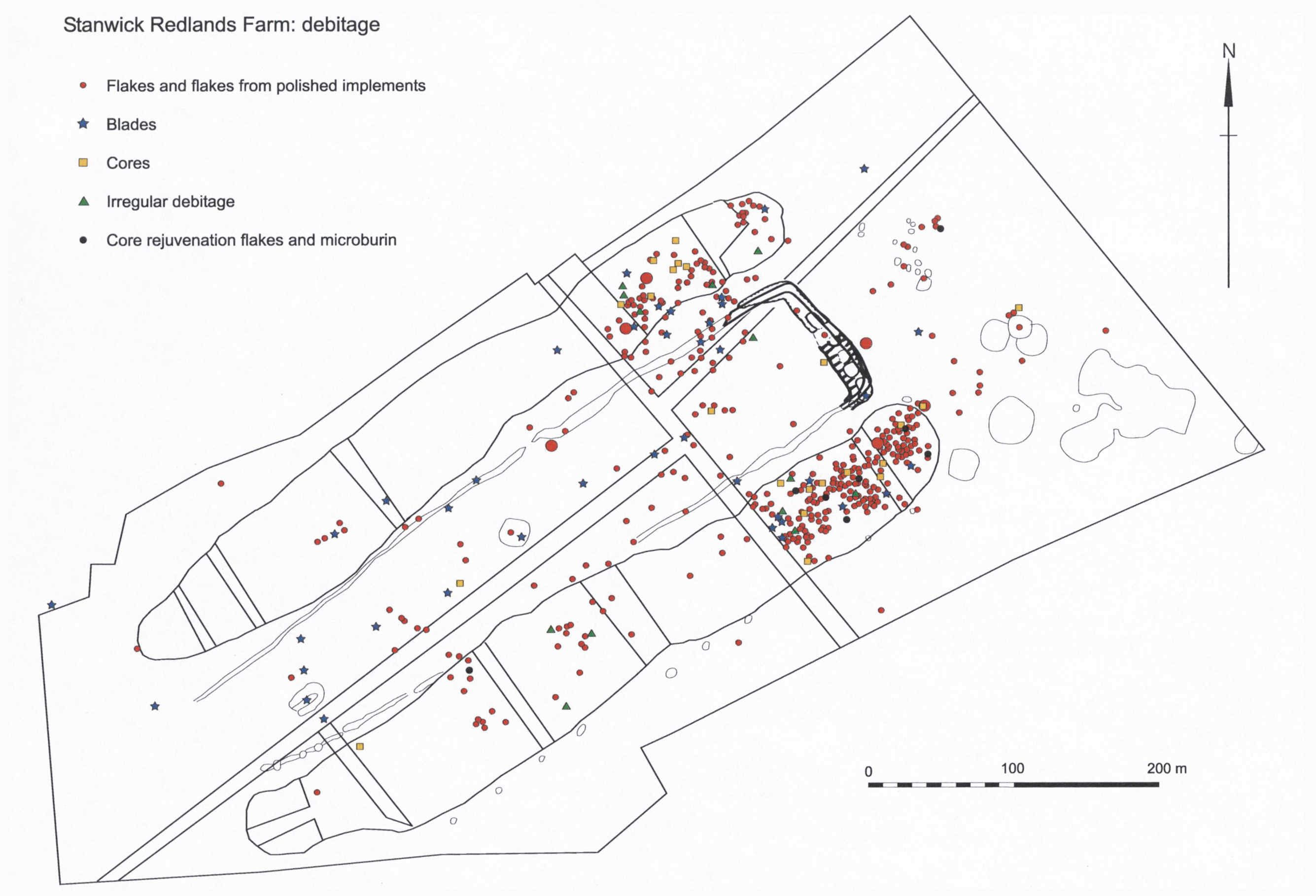
Environmental remains attributable to the Late Mesolithic or Early Neolithic have been retrieved from a variety of contexts across the region[35], including rare examples of settlements spanning this transition period[36], upland peat bogs[37] and organic palaeochannel deposits, notably along the Trent Valley at Bole Ings, Girton and Staythorpe in Nottinghamshire[38] and in the Nene Valley at the Northamptonshire sites of Wellingborough, Wollaston and Stanwick[39]. However, significantly more organically rich contexts of this period need to be targeted for environmental analysis and radiocarbon dating to elucidate patterns of landscape change during this key transitional period. Particular attention should be focused upon sites preserving organic remains that may be threatened by de-watering, while the information gained from sites under threat from development should be maximised. Discoveries of organic remains from sites such as Aston-on-Trent, Derbyshire, where Early Neolithic Grimston Ware sherds and prolific emmer wheat seeds survived beneath a much denuded Early Bronze Age barrow[40], and the nearby site at Potlock[41], where the lower fill of a cursus ditch yielded wheat and barley grains as well as seeds of blackberry, sloe, elder and hawthorn, emphasise the potential for environmental analysis. However, more sites of this period with the potential for preserved organic remains need to be sampled and carried through to publication if we are to unravel the transition from nomadic to semi-sedentary and sedentary communities and the impact of these changes upon the landscape.
Agenda topics addressed: 3.1.1; 3.2.1; 3.2.3; 3.3.1-3.3.3; 3.4.1-3.4.3
Identify monument complexes and prioritise for curatorial action
Summary:
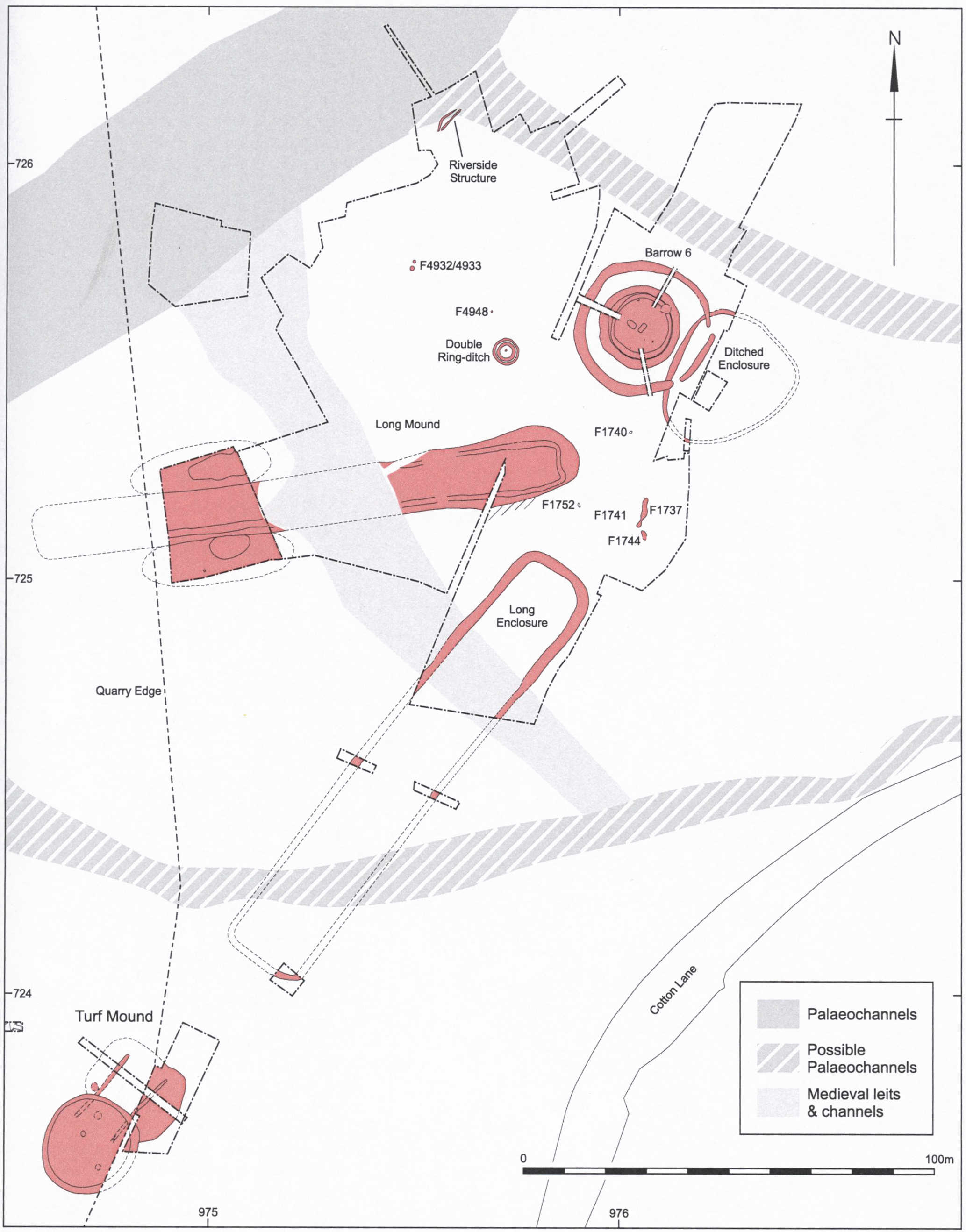
Neolithic and Bronze Age monument complexes are poorly known by comparison with areas such as Wessex, but there is compelling evidence nonetheless for landscapes of equal complexity. Impressive earthwork complexes survive on the Derbyshire uplands, notably around the henge at Arbor Low[42] and on Stanton Moor[43], but lowland complexes must be deduced principally from cropmarks[44][45]. It is important to identify surviving examples, establish the variety of monuments and ensure that appropriate curatorial decisions can be made concerning their preservation. This is particularly urgent in lowland areas such as the Nene Valley and Tame-Trent confluence, where quarrying and other pressures pose major challenges for the management of landscapes that in terms of their complexity rival the great Wessex monument complexes[46]. Much remains to be done on establishing the chronology and components of monument complexes, locational preferences and intra-regional variability in monument associations. Spatial variability is particularly difficult to demonstrate, but is indicated, for example, by the tight focus of cursus-based complexes in the Middle Trent and Soar Valleys[47] and a propensity in the Lincolnshire Wolds for long funerary enclosures to be associated with mounds of various shapes[48].
Agenda topics addressed: 3.4.3; 3.6.1-3.6.4; 3.7.2; 3.7.3; 3.8.1
Conduct additional investigations of earlier Neolithic funerary traditions
Summary:

Funerary traditions involving the construction of timber chambered barrows, as at Skendleby in Lincolnshire[49], and outside the region at the Cambridgeshire site of Haddenham[50], clearly relate to practices that are found extensively along the eastern side of England and Scotland. Cropmark evidence from Leicestershire and Northamptonshire suggests that similar monuments may be found in these areas[51], but Derbyshire presents a very different picture. Here, there is seemingly a very wide range of stone-built monuments[52][53]. Some of these, including the excavated monument at Whitwell[54], bear comparison with the mainstream of cairns of western England. Others, however, are characterised by a confusing variety of poorly recorded evidence[55]. There is a need for further excavation to elucidate the details of cairn construction and to retrieve coherent skeletal assemblages, artefacts and samples for scientific dating and stable isotope analysis (see Objective 3H). It is recommended that this be undertaken in conjunction with fieldwork designed to identify associated activity areas and other related monuments.
Agenda topics addressed: 3.1.4; 3.2.4; 3.4.3; 3.6.2-3.6.4; 3.8.1-3.8.3; 3.9.3
Recover and analyse human remains
Summary:

Rare discoveries of human bone in Mesolithic contexts and more frequent discoveries on Neolithic to Middle Bronze Age sites highlight both their potential for analysis and the inadequacies of the current data set. Mesolithic material is especially sparse, and is best represented in the region by the discovery of a female femur associated with animal bone preserving evidence of butchery in the fill of a palaeochannel at Staythorpe in Nottinghamshire[56][57]. This remarkable find was dated by radiocarbon to 5740-5620 cal BC (Beta-14401; 95% probability) and was shown by stable isotope analysis to derive from an individual heavily reliant on animal protein, with a surprising dearth of plant foods and no influence of coastal food resources. Neolithic and Bronze Age remains have been retrieved more frequently, particularly from funerary[58][59] and watery[60] contexts, but interpretation is seriously restricted by the limited scope of most analyses. It is recommended that more emphasis be placed upon appropriate sampling strategies and analyses, with the development of further ground-breaking programmes such as the isotopic analysis of Beaker skeletal remains that is currently being undertaken at the University of Sheffield[61], alongside detailed studies of burial contexts, dentition and skeletal remains. Radiocarbon dating of human remains should be conducted as a matter of routine, with appropriate application of Bayesian modelling (Objective 3A).
Agenda topics addressed: 3.1.1; 3.1.4; 3.2.4; 3.3.2; 3.7.2; 3.8.2; 3.8.3
Investigate the development and intensification of agriculture
Summary:

Trent Valley Landscapes. Kings Lynn: Heritage Marketing and Publications, 52; photograph: Andy Howard)Although traditionally seen as a period of agricultural innovation, evidence for a transition from a hunter-gatherer to an agricultural economy has proved stubbornly absent. Current interpretations assume a variable conversion in southern Britain to an agricultural economy that may have focused initially on cattle herding, with arable agriculture developing more slowly at a smaller scale[62]. Within the East Midlands, there is some evidence to support this hypothesis, notably from north Derbyshire peat bogs preserving pollen that may indicate small-scale disturbances to vegetation in response to early animal herding[63]. In addition, sites of this period generally yield very limited evidence for domesticated crops and animals[64], reflecting perhaps a slow conversion to an agricultural economy. There are indications on some sites of a greater abundance of animal bones and botanical indicators of cultivation from the later Neolithic[65], while studies of upland peats[66] and palaeochannel deposits[67] have yielded evidence for accelerating woodland clearance towards the end of the period. To clarify further the development of farming communities, additional targeted sampling of palaeochannels, peat bogs and other locations likely to preserve environmental remains of these periods is recommended. It is suggested that this be combined with studies of soil micromorphology and geochemistry, which may provide valuable information on the extension of cultivation and agricultural intensification. Special emphasis should be placed on the recovery of large assemblages of animal bone from excavations[68].
Agenda topics addressed: 3.2.1; 3.3.1-3.3.3; 3.4.2; 3.5.3
Foster relevant artefact studies
Summary:
Considerable advances in artefact studies have been made in recent years, but further research would be particularly welcome on the dating of ceramic and lithic artefacts, the production and distribution of pottery, stone tools and metalwork, and residue analyses of pottery. Resources could usefully be focused upon radiocarbon dating of carbonised accretions on pottery and of stratified lithic assemblages associated with pots preserving accretions datable by radiocarbon or short-life carbonised material. Petrographic analyses of lithic artefacts and pottery have demonstrated complex exchange networks, exemplified by a distinctive suite of stone axes and other artefacts around Arbor Low[69] in Derbyshire, Group XX polished stone axes derived from unlocated quarry sites in Charnwood Forest[70] and Neolithic and Bronze Age pottery tempered with granitoid inclusions derived from Mountsorrel and other Charnwood sources[71]. Further scientific analyses are recommended to refine our understanding of the production and distribution of these materials[72]. There is also significant scope for investigating further the exchange networks fossilised in the distribution of pottery and other artefacts of the Beaker ‘package'[73], while studies of Bronze Age metalwork may elucidate production and distribution systems extending far beyond the East Midlands[74]. Particular attention should also be paid to analyses of the surface and absorbed organic residues preserved in pottery, as these may provide important insights into vessel functions, the materials processed in pottery vessels, and the wider economy[75]. This potential is illustrated by analyses of Neolithic pottery from Willington in Derbyshire, where lipid analysis revealed traces of ruminant dairy and porcine fats[76].
Agenda topics addressed: 3.1.2; 3.8.1; 3.8.2; 3.9.1-3.9.4
| 3A | 3B | 3C | 3D | 3E | 3F | 3G | 3H | 3I | 3J |
Strategic Objective 3A
Compile database of scientific dates and extend application of Bayesian modelling for radiocarbon dating
Summary:
Reviews of radiocarbon dates for the Neolithic and Bronze Age have been prepared for some areas of the East Midlands[1], but there is a pressing need for an up-to-date database for the entire region that could be employed as a springboard for prioritised dating programmes. These should take full account of progress in Bayesian modelling, which rests upon the acquisition of multiple radiocarbon dates and their analysis in the context of the excavated evidence[2]. Existing archives should be reviewed to identify those most likely to contain data appropriate for Bayesian analysis. These techniques offer exciting new opportunities to refine the chronology of excavated sites and to provide reliable cross-referencing to dated sites from elsewhere in the country[3]. The method is particularly useful for periods such as the earlier Neolithic, which offers complex monument sequences and lengthy phases of conservatism in the manufacture of ceramic and lithic items, and could usefully be applied to such poorly dated monuments as the chambered and long cairns of the Peak District[4]. Successful applications of the technique in the East Midlands include a Neolithic funerary cairn at Whitwell, allowing it to be placed firmly within the continuum occupied by the Cotswold-Severn chambered tombs[5], burnt mounds at Willington[6] and the Raunds monument complex[7].
Agenda topics addressed: 3.1.1-3.1.4; 3.3.1-3.3.4; 3.5.2; 3.5.3; 3.6.1; 3.7.1; 3.7.2
Archaeology of the East Midlands: 86-87, 289
Other research frameworks:
EH Research Strategy for Prehistory 2011: Theme PR3, Topic 18 (Prehistoric material culture in context); Theme PR4, Topic 24 (Building chronologies for prehistory); Theme PR5, Topic 26 (Developing dating techniques).
EH National Heritage Science Strategy Report 2 2009: Section 3.2.1 (Chronology)
Prehistoric Ceramics Research Group 2010 The Study of Later Prehistoric Pottery: General Policies and Guidelines for Analysis and Publication, 4
References:
[1] eg Barnatt, J 1995 ‘Neolithic and Bronze Age radiocarbon dates from the Peak District’. Derbyshire Archaeological Journal 115, 5-19
[2] Buck, C E, Cavanagh, W G and Litton, C D 1996 Bayesian Approach to Interpreting Archaeological Data. Chichester: Wiley
[3] Whittle, A, Healy, F and Bayliss, A 2011 Gathering Time: Dating the Earlier Neolithic Enclosures of Southern Britain and Ireland. Oxford: Oxbow Books
[4] Barnatt, J and Collis, J 1996 Barrows in the Peak District: Recent Research. Sheffield: J.R. Collis Publications
[5] Marshall, P, Bayliss, A and Wall, I et al 2011 ‘Radiocarbon dating’ in Vyner, B and Wall, I, ‘A Neolithic cairn at Whitwell, Derbyshire’. Derbyshire Archaeological Journal 131, 30-40.
[6] Beamish, M G 2009 ‘Island visits: Neolithic and Bronze Age activity on the Trent Valley floor. Excavations at Egginton and Willington, Derbyshire, 1998-1999’. Derbyshire Archaeological Journal 129, 17-182
[7] Harding, J and Healy, F 2007 The Raunds Area Project. A Neolithic and Bronze Age Landscape in Northamptonshire. Swindon: English Heritage
Assess the fieldwalking resource
Summary:
There is a long tradition of fieldwalking across the region, but there has been comparatively little synthesis at the regional scale of the results of these surveys. Some of this information has been published[8] but most resides in museum collections or in Historic Environment Records. In neither case is the detail of the information always readily accessible. A review of the results of fieldwalking surveys is recommended as a means of highlighting intra-regional contrasts in the spatial distribution of artefacts, combined with further study of museum collections[9]. Such work may contribute in turn to the development of future programmes of investigation. In Leicestershire and northern Northamptonshire, for example, lithic scatters indicate activity areas, many of them in clayland environments, at slightly lower elevations than Mesolithic lithic scatters but at much the same distance from water sources[10][11]. In contrast, surveys in Derbyshire on the uplands and in some valley locations indicate a close correlation between the locations of earlier Neolithic and later Mesolithic lithic scatters[12]. Debate continues on the interpretation of artefact distribution patterns, but the potential of fieldwalking for developing our understanding of early settlement is illustrated by a number of intra-regional synthetic studies[13] and by excavations of several scatters recorded during fieldwalking. These include Rothley, Leicestershire, where excavations of a clayland lithic scatter revealed domestic activity associated with Peterborough ware, Grooved Ware and an unusual carved stone plaque[14], and Mount Pleasant, Kenslow, Derbyshire, where excavations of several lithic clusters revealed a group of four small pits and Grimston, Peterborough and Grooved Ware deriving probably from separate phases of occupation[15]. Close analysis of fieldwalking assemblages should, therefore, enable excavation of finds scatters to be better targeted[16].
Agenda topics addressed: 3.1.3; 3.2.1; 3.2.2; 3.3.1; 3.4.1; 3.4.3; 3.5.2; 3.5.4; 3.6.4; 3.8.1; 3.9.1
Archaeology of the East Midlands: 86-87
Other research frameworks:
EH Research Strategy for Prehistory 2011: Theme PR2, Topic 14 (Understanding and protecting ‘sites without structures’); Theme PR8, Topics 41 (Realising the potential of prehistoric archives and collections) and 46 (Making HERs and related sources more accurate, relevant and useful for prehistory)
Lithic Studies Society 2004 Research frameworks for Holocene Lithics in Britain, 2-3, 7
References:
[8] eg Knight, D, Garton, D and Leary, R 1998 ‘The Elmton fieldwalking survey: Prehistoric and Romano-British artefact scatters’. Derbyshire Archaeological Journal 118, 69-85; Parry, S, 2006 Raunds Area Survey: an Archaeological Study of the Landscape of Raunds, Northamptonshire, 1985-94. Oxford: Oxbow Books
[9] eg Buxton Museum: large collections of systematically collected lithic material from across the Peak District are ripe for analysis and publication.
[10] Clay, P 2006 ‘The Neolithic and Early to Middle Bronze Age’ in The Archaeology of the East Midlands, 73
[11] Clay, P, 2002 The Prehistory of the East Midlands Claylands (University of Leicester Archaeology Monograph 9). Leicester: University of Leicester, 109-114
[12] Clay 2006, 73; Hart, C, 1981 The North Derbyshire Archaeological Survey. Chesterfield: North Derbyshire Archaeological Trust, 24-47
[13] eg Bradley, R and Hart, C 1983 ‘Prehistoric settlement in the Peak District during the third and second millennia bc: A preliminary analysis in the light of recent fieldwork’. Proceedings of the Prehistoric Society 49, 177-193; Garton, D 2007 ‘Flintwork and medieval pottery from fieldwalking over cropmarks on the Sherwood Sandstone of North Nottinghamshire’. Transactions of the Thoroton Society 111, 15-32; Knight et al 1998
[14] Cooper, L and Hunt, L 2005 ‘An engraved Neolithic plaque with Grooved Ware associations’. PAST (Newsletter of the Prehistoric Society) 50, 14-15
[15] Garton, D and Beswick, P 1983 ‘The survey and excavation of a Neolithic settlement area at Mount Pleasant, Kenslow, 1980-1983’. Derbyshire Archaeological Journal 103, 7-40
[16] See also Garton, D 1989 ‘Flintwork distributions: the excavation record’ in Brooks, I and Phillips, P (eds) Breaking the Stony Silence (British Archaeological Reports British Series 213). Oxford: B.A.R, 91-108
Develop fieldwalking strategies and guidelines for landscape zones
Summary:
Synthesis of the results of fieldwalking (3B) should enable the development of more refined strategies for locating and interpreting the lithic scatters that provide crucial evidence for early prehistoric activity. There is a pressing need to investigate further the lithic signatures of monument types, as this may assist the interpretation of finds scatters. In addition, building upon projects in areas such as the Fens[17], the Nene and Ouse catchments around Raunds[18] and the Peak District[19], and upon smaller-scale surveys such as Elmton in Derbyshire[20], it would be useful if further surveys could be conducted across a wide spectrum of landscape zones. This would permit a more informed assessment of variations in the density and character of settlement and comparison of the lithic evidence with earthwork, cropmark and other remote sensing data across a wide range of geological and topographic zones[21]. It should also provide a secure foundation for the development of guidelines specific to particular landscape zones and aid identification of methodologies capable of detecting sites that are not easily located[22]. A review of the excavation record may also illuminate the nature of lithic assemblages recovered by fieldwalking[23].
Agenda topics addressed: 3.2.1; 3.2.2; 3.4.1; 3.4.3; 3.5.4; 3.6.4; 3.8.1
Archaeology of the East Midlands: 86-87
Other research frameworks:
EH Research Strategy for Prehistory 2011: Theme PR2, Topic 14 (Understanding and protecting ‘sites without structures’)
Lithic Studies Society 2004. Research frameworks for Holocene Lithics in Britain, 2-3
References
[17] Hayes, P and Lane, T 1992 The Fenland Project, No. 5: Lincolnshire Survey, The SW Fen. East Anglian Archaeology 55; Lane, T 1993 The Fenland Project, No. 8: Lincolnshire Survey, The Northern Fen Edge. East Anglian Archaeology 66
[18] Parry, S 2006 Raunds Area Survey: an Archaeological Study of the Landscape of Raunds, Northamptonshire, 1985-94. Oxford: Oxbow Books
[19] Barnatt, J 1996 ‘Moving beyond the monuments: Paths and people in the Neolithic landscapes of the Peak District’ in Frodsham, P (ed) Neolithic Studies in No-Man’s Land: Papers on the Neolithic of Northern England from Trent to the Tweed (Northern Archaeology 13/14). Northumberland Archaeology Group, 43-59
[20] Knight, D, Garton, D and Leary, R 1998 ‘The Elmton fieldwalking survey: prehistoric and Romano-British artefact scatters’. Derbyshire Archaeological Journal 118, 69-85
[21] Clay, P 2006 ‘Claylands Archaeology: Summary and prospect’ in Mills, J and Palmer, R (eds) Populating Clay Landscapes. Stroud: Tempus, 147-156
[22] eg earlier Neolithic scatters: Clay, P 2006 ‘The Neolithic and Early to Middle Bronze Age’ in The Archaeology of the East Midlands, 87
[23] Garton, D 1989 ‘Flintwork distributions: The excavation record’ in Brooks, I and Phillips, P (eds) Breaking the Stony Silence (British Archaeological Reports British Series 213). Oxford: B.A.R, 91-108
Assess the regional air photographic and lidar resource
Summary:
Many of Britain’s principal Neolithic and earlier Bronze Age monuments, which in the East Midlands include round and long earthen barrows or cairns[24][25][26], funerary enclosures[27], henges, timber or stone circles[28], cursus monuments[29] and causewayed enclosures[30], may be distinguished from the air by merit of their highly distinctive morphology[31]. Significant parts of the region are characterised by pasture or woodland, or are otherwise unsuited to cropmark formation on account of the underlying geology or the presence of masking deposits such as alluvium, colluvium or coversands. With this proviso, however, and with reference to English Heritage’s National Mapping Programme, review of the region’s air photographic resource should permit identification of many of the principal monument complexes, confirmation of their landscape settings and an initial indication of the range of components (Objective 3F]). Significantly, all but one of the eight known Neolithic causewayed enclosures in the region have been revealed by air photography[32], emphasising the effectiveness of this approach. The contribution of lidar, which may identify monuments preserved in pasture or concealed in dense woodland, bracken or heather[33], and of other airborne remote sensing methods[34] should also be considered.
Agenda topics addressed: 3.3.4; 3.4.1-3.4.3; 3.6.1-3.6.3; 3.7.2; 3.7.3; 3.8.1
Archaeology of the East Midlands: 87
Other research frameworks:
EH Research Strategy for Prehistory 2011: Theme PR1, Topics 2 (Political and ritual landscapes in prehistory) and 5 (Addressing gaps in our knowledge of prehistoric landscapes); Theme PR2, Topics 10 (Setting prehistoric sites in context) and 12 (Characterising and classifying prehistoric sites and monuments)
EH National Heritage Science Strategy Report 2 2009: Section 3.5.1 (Detecting and imaging)
References:
[24] Jones, D 1998 ‘Long barrows and elongated enclosures in Lincolnshire: An analysis of the air photographic evidence’. Proceedings of the Prehistoric Society 64, 83-114
[25] Barnatt, J and Collis, J (eds) 1996 Barrows in the Peak District. Sheffield: J.R. Collis Publications
[26] Hart, C R 1986 ‘Searches for the Early Neolithic: A study of Peakland long cairns’ in Manby, T G and Turnbull, P (eds) Archaeology in the Pennines (British Archaeological Reports British Series 158). Oxford: B.A.R, 127-136
[27] Jones 1998
[28] Barnatt, J 1990 The Henges, Stone Circles and Ringcairns of the Peak District (University of Sheffield Archaeological Monograph 1) Sheffield: University of Sheffield
[29] Clay, P 2006 ‘The Neolithic and Early to Middle Bronze Age’ in The Archaeology of the East Midlands, 13, 76; Barclay, A and Harding, J (eds) 1999 Pathways and Ceremonies: the Cursus Monuments of Britain and Ireland. Oxford: Oxbow Books
[30] Oswald, A, Dyer, C and Barber, M 2001 The Creation of Monuments: Neolithic Causewayed Enclosures in the British Isles. Swindon: English Heritage
[31] Darvill, T 1996 Prehistoric Britain From the Air: A Study of Space, Time and Society. Cambridge: Cambridge University Press, especially 29, 179 and 183
[32]Clay 2006, 74
[33] Crutchley, S and Crow, P 2009 The Light Fantastic: Using Airborne Laser Scanning in Archaeological Survey. Swindon: English Heritage
[34] Williams, J 2009 The use of Science to Enhance Our Understanding of the Past. National Heritage Science Strategy Report 2, Section 3.5.1
Target sites with Late Mesolithic and Early Neolithic organic remains
Summary:
Environmental remains attributable to the Late Mesolithic or Early Neolithic have been retrieved from a variety of contexts across the region[35], including rare examples of settlements spanning this transition period[36], upland peat bogs[37] and organic palaeochannel deposits, notably along the Trent Valley at Bole Ings, Girton and Staythorpe in Nottinghamshire[38] and in the Nene Valley at the Northamptonshire sites of Wellingborough, Wollaston and Stanwick[39]. However, significantly more organically rich contexts of this period need to be targeted for environmental analysis and radiocarbon dating to elucidate patterns of landscape change during this key transitional period. Particular attention should be focused upon sites preserving organic remains that may be threatened by de-watering, while the information gained from sites under threat from development should be maximised. Discoveries of organic remains from sites such as Aston-on-Trent, Derbyshire, where Early Neolithic Grimston Ware sherds and prolific emmer wheat seeds survived beneath a much denuded Early Bronze Age barrow[40], and the nearby site at Potlock[41], where the lower fill of a cursus ditch yielded wheat and barley grains as well as seeds of blackberry, sloe, elder and hawthorn, emphasise the potential for environmental analysis. However, more sites of this period with the potential for preserved organic remains need to be sampled and carried through to publication if we are to unravel the transition from nomadic to semi-sedentary and sedentary communities and the impact of these changes upon the landscape.
Agenda topics addressed: 3.1.1; 3.2.1; 3.2.3; 3.3.1-3.3.3; 3.4.1-3.4.3
Archaeology of the East Midlands: 86, 267-268
Other research frameworks:
EH Research Strategy for Prehistory 2011: Theme PR1, Topics 7 (Mobility and sedentism in prehistoric agricultural societies) and 9 (Reconstructing Pleistocene and Early Holocene landscapes); Theme PR4, Topic 23 (Key transitions in prehistory); Theme PR6, Topic 31 (Human interactions with plants and animals in prehistory)
EH National Heritage Science Strategy Report 2 2009: Section 3.3.1 (People and environment)
References:
[35] Monckton, A 2006 ‘Environmental Archaeology’ in the East Midlands in The Archaeology of the East Midlands, 264-266
[36] eg Garton, D forthcoming The Excavation of a Mesolithic and Neolithic Settlement at Lismore Fields, Buxton, Derbyshire. Oxford: Oxbow Books
[37] Hicks, S P 1972 ‘The impact of Man on the East Moor of Derbyshire from Mesolithic times’. Archaeological Journal 129, 1-21
[38] Howard, A J and Knight, D 2004 ‘Mesolithic hunter-gatherers’ in Knight, D and Howard, A J Trent Valley Landscapes. Kings Lynn: Heritage Marketing and Publications, 33-35
[39] Brown, A G 2000 ‘Floodplain vegetation history: Clearings as potential ritual spaces?’ in Fairbairn, A S (ed) Plants in Neolithic Britain and Beyond. Oxford: Oxbow Books, 49-62; Allen, P, Brown, A G, Meadows, I et al 2009 Nene Valley: Archaeological and Environmental Synthesis. Northamptonshire Archaeology and University of Exeter (http://archaeologydataservice.ac.uk/archives/view/nenevalley_eh_2009/).
[40] Loveday, R 2000 ‘Aston: A barrow preserved’. Current Archaeology 167, 438-439; Loveday, R 2012 ‘Aston on Trent 1, Derbyshire: Excavation of a long barrow and protected cursus land surface’. Derbyshire Archaeological Journal 132, 80-128; Reaney, D 1968 ‘Beaker burials in south Derbyshire’. Derbyshire Archaeological Journal 88, 68-81
[41] Guilbert, G 1996 ‘Findern is dead, long live Potlock: The story of a cursus on the Trent gravels’. PAST (Newsletter of the Prehistoric Society) 24, 10-12
Identify monument complexes and prioritise for curatorial action
Summary:
Neolithic and Bronze Age monument complexes are poorly known by comparison with areas such as Wessex, but there is compelling evidence nonetheless for landscapes of equal complexity. Impressive earthwork complexes survive on the Derbyshire uplands, notably around the henge at Arbor Low[42] and on Stanton Moor[43], but lowland complexes must be deduced principally from cropmarks[44][45]. It is important to identify surviving examples, establish the variety of monuments and ensure that appropriate curatorial decisions can be made concerning their preservation. This is particularly urgent in lowland areas such as the Nene Valley and Tame-Trent confluence, where quarrying and other pressures pose major challenges for the management of landscapes that in terms of their complexity rival the great Wessex monument complexes[46]. Much remains to be done on establishing the chronology and components of monument complexes, locational preferences and intra-regional variability in monument associations. Spatial variability is particularly difficult to demonstrate, but is indicated, for example, by the tight focus of cursus-based complexes in the Middle Trent and Soar Valleys[47] and a propensity in the Lincolnshire Wolds for long funerary enclosures to be associated with mounds of various shapes[48].
Agenda topics addressed: 3.4.3; 3.6.1-3.6.4; 3.7.2; 3.7.3; 3.8.1
Archaeology of the East Midlands: 87
Other research frameworks:
EH Research Strategy for Prehistory 2011: Themes PR1, Topic 2 (Political and ritual landscapes in prehistory) and PR2, Topics 10 (Setting prehistoric sites in context) and 12 (Characterising and classifying prehistoric sites and monuments)
References:
[42] Barnatt, J 1990.The Henges, Stone Circles and Ringcairns of the Peak District (University of Sheffield Archaeological Monograph 1). Sheffield: University of Sheffield, 31-38; Bradley, R and Hart, C 1983 ‘Prehistoric settlement in the Peak District during the third and second millennia bc’. Proceedings of the Prehistoric Society 49, 177-193
[43] Barnatt 1990, 75-79; Hart, C R 1985 ‘Stanton Moor, Derbyshire: burial and ceremonial monuments’ in Spratt, D and Burgess, C (eds) Upland Settlement in Britain (British Archaeological Reports British Series 143). Oxford: B.A.R, 77-99
[44] Clay, P 2006 ‘The Neolithic and Early to Middle Bronze Age’ in The Archaeology of the East Midlands, 74-76, 79-81
[45] eg Harding, J and Healy, F 2007 The Raunds Area Project. A Neolithic and Bronze Age Landscape in Northamptonshire. Swindon: English Heritage; Thomas, J 2008 Monument, Memory and Myth: Use and Re-use of Three Bronze Age Round Barrows at Cossington, Leicestershire (University of Leicester Archaeology Monograph 14). Leicester: University of Leicester
[46] eg Buteux, S and Chapman, H 2009 Where Rivers Meet. The Archaeology of Catholme and the Trent-Tame Confluence (CBA Research Report 161). York: Council for British Archaeology
[47] Loveday, R 2004 ‘Contextualising monuments: The exceptional potential of the Middle Trent Valley’. Derbyshire Archaeological Journal 124, 1-12
[48] Jones, D 1998 ‘Long barrows and elongated enclosures in Lincolnshire: An analysis of the air photographic evidence’. Proceedings of the Prehistoric Society 64, 83-114
Conduct additional investigations of earlier Neolithic funerary traditions
Summary:
Funerary traditions involving the construction of timber chambered barrows, as at Skendleby in Lincolnshire[49], and outside the region at the Cambridgeshire site of Haddenham[50], clearly relate to practices that are found extensively along the eastern side of England and Scotland. Cropmark evidence from Leicestershire and Northamptonshire suggests that similar monuments may be found in these areas[51], but Derbyshire presents a very different picture. Here, there is seemingly a very wide range of stone-built monuments[52][53]. Some of these, including the excavated monument at Whitwell[54], bear comparison with the mainstream of cairns of western England. Others, however, are characterised by a confusing variety of poorly recorded evidence[55]. There is a need for further excavation to elucidate the details of cairn construction and to retrieve coherent skeletal assemblages, artefacts and samples for scientific dating and stable isotope analysis (see Objective 3H). It is recommended that this be undertaken in conjunction with fieldwork designed to identify associated activity areas and other related monuments.
Agenda topics addressed: 3.1.4; 3.2.4; 3.4.3; 3.6.2-3.6.4; 3.8.1-3.8.3; 3.9.3
Archaeology of the East Midlands: 87
Other research frameworks:
EH Research Strategy for Prehistory 2011: Theme PR2, Topics 10 (Setting prehistoric sites in context) and 12 (New approaches to the classification of prehistoric sites and monuments); Theme PR3, Topic 20 (The place and role of the dead in prehistory)
EH National Heritage Science Strategy Report 2 2009: Sections 3.2.1 (Chronology) and 3.3.1 (People and environment)
References:
[49] Evans, J G and Simpson, D D A 1991 ‘Giant’s Hills 2 long barrow, Skendleby, Lincolnshire’. Archaeologia 91, 1-45
[50] Evans, C and Hodder, I 2006 A Woodland Archaeology: Neolithic Sites at Haddenham. Cambridge: MacDonald Institute for Archaeological Research
[51] Clay, P 2006 ‘The Neolithic and Early to Middle Bronze Age’ in The Archaeology of the East Midlands, 75
[52] Barnatt, J and Collis, J 1996 Barrows in the Peak District: Recent Research. Sheffield: J.R. Collis Publications
[53] Hart, C R 1986 ‘Searches for the Early Neolithic: A study of Peakland long cairns’ in Manby, T G and Turnbull, P (eds) Archaeology in the Pennines (British Archaeological Reports British Series 158). Oxford: B.A.R, 127-136
[54] Vyner, B E and Wall, I 2011 ‘A Neolithic cairn at Whitwell, Derbyshire’. Derbyshire Archaeological Journal 131, 1-131
[55] Barnatt and Collis 1996; Hart 1986
Recover and analyse human remains
Summary:
Rare discoveries of human bone in Mesolithic contexts and more frequent discoveries on Neolithic to Middle Bronze Age sites highlight both their potential for analysis and the inadequacies of the current data set. Mesolithic material is especially sparse, and is best represented in the region by the discovery of a female femur associated with animal bone preserving evidence of butchery in the fill of a palaeochannel at Staythorpe in Nottinghamshire[56][57]. This remarkable find was dated by radiocarbon to 5740-5620 cal BC (Beta-14401; 95% probability) and was shown by stable isotope analysis to derive from an individual heavily reliant on animal protein, with a surprising dearth of plant foods and no influence of coastal food resources. Neolithic and Bronze Age remains have been retrieved more frequently, particularly from funerary[58][59] and watery[60] contexts, but interpretation is seriously restricted by the limited scope of most analyses. It is recommended that more emphasis be placed upon appropriate sampling strategies and analyses, with the development of further ground-breaking programmes such as the isotopic analysis of Beaker skeletal remains that is currently being undertaken at the University of Sheffield[61], alongside detailed studies of burial contexts, dentition and skeletal remains. Radiocarbon dating of human remains should be conducted as a matter of routine, with appropriate application of Bayesian modelling (Objective 3A).
Agenda topics addressed: 3.1.1; 3.1.4; 3.2.4; 3.3.2; 3.7.2; 3.8.2; 3.8.3
Archaeology of the East Midlands: 87, 265 and 267
Other research frameworks:
EH Research Strategy for Prehistory 2011: Theme 3, Topics 21 (Eating and drinking in prehistory) and 22 (Prehistoric communities and individuals); Theme PR5, Topic 27 (Developing scientific techniques for prehistory)
EH National Heritage Science Strategy Report 2 2009: Section 3.3.1 (People and environment)
References:
[56] Davis, G 2001 Interim Statement on the Archaeological Works at Staythorpe Power Station (University of Sheffield, ARCUS Report 438f). Sheffield: University of Sheffield
[57] Howard, A J and Knight, D 2004 ‘Mesolithic hunter-gatherers’ in Knight, D and Howard, A J Trent Valley Landscapes. Kings Lynn: Heritage Marketing and Publications, 38-39
[58] Barnatt, J and Collis, J 1996 Barrows in the Peak District: Recent Research. Sheffield: J.R. Collis Publications
[59] Garton, D, Howard, A J and Pearce, M 1996 ‘Neolithic riverside ritual? Excavations at Langford Lowfields, Nottinghamshire’ in Wilson, R J A (ed) From River Trent to Raqqa (University of Nottingham, Nottingham Studies in Archaeology 1). Nottingham: University of Nottingham, 9-11
[60] Knight, D and Howard, A J 2004 ‘From Neolithic to Early Bronze Age: The first agricultural landscapes’ in Knight and Howard 2004, 54-56
[61] http://www.shef.ac.uk/archaeology/research/beaker-isotope/index.html
Investigate the development and intensification of agriculture
Summary:
Trent Valley Landscapes. Kings Lynn: Heritage Marketing and Publications, 52; photograph: Andy Howard)Although traditionally seen as a period of agricultural innovation, evidence for a transition from a hunter-gatherer to an agricultural economy has proved stubbornly absent. Current interpretations assume a variable conversion in southern Britain to an agricultural economy that may have focused initially on cattle herding, with arable agriculture developing more slowly at a smaller scale[62]. Within the East Midlands, there is some evidence to support this hypothesis, notably from north Derbyshire peat bogs preserving pollen that may indicate small-scale disturbances to vegetation in response to early animal herding[63]. In addition, sites of this period generally yield very limited evidence for domesticated crops and animals[64], reflecting perhaps a slow conversion to an agricultural economy. There are indications on some sites of a greater abundance of animal bones and botanical indicators of cultivation from the later Neolithic[65], while studies of upland peats[66] and palaeochannel deposits[67] have yielded evidence for accelerating woodland clearance towards the end of the period. To clarify further the development of farming communities, additional targeted sampling of palaeochannels, peat bogs and other locations likely to preserve environmental remains of these periods is recommended. It is suggested that this be combined with studies of soil micromorphology and geochemistry, which may provide valuable information on the extension of cultivation and agricultural intensification. Special emphasis should be placed on the recovery of large assemblages of animal bone from excavations[68].
Agenda topics addressed: 3.2.1; 3.3.1-3.3.3; 3.4.2; 3.5.3
Archaeology of the East Midlands: 86
Other research frameworks:
EH Research Strategy for Prehistory 2011: Theme PR1, Topic 7 (Mobility and sedentism in prehistoric agricultural societies); Theme PR4, Topic 23: (Key transitions in prehistory); Theme PR6, Topic 31 (Human interactions with plants and animals in prehistory)
EH National Heritage Science Strategy Report 2 2009: Section 3.3.1 (People and environment)
References:
[62] Bradley, R 2007 The Prehistory of Britain and Ireland. Cambridge: Cambridge University Press, 27-38
[63] Hicks, S P 1972 ‘The impact of man on the East Moors of Derbyshire from Mesolithic times’. Archaeological Journal 129, 1-21
[64] Monckton, A 2006 ‘Environmental Archaeology in the East Midlands’ in The Archaeology of the East Midlands, 265-267
[65] eg Evans, J G and Simpson, D D A 1991 ‘Giant’s Hills 2 long barrow, Skendleby, Lincolnshire’. Archaeologia 91, 21-23
[66] eg Long, D J, Chambers, F M and Barnatt, J 1998 ‘The palaeoenvironment and the vegetation history of a later prehistoric field system at Stoke Flat on the gritstone uplands of the Peak District’. Journal of Archaeological Science 25, 505-19
[67] eg Smith, D N, Roseff, R, Bevan, L et al 2005 ‘Archaeological and environmental investigations of a Late Glacial and Holocene river valley sequence on the River Soar at Croft, Leicestershire’. The Holocene 15 (2)
[68] Williams, J 2009 The Use of Science to Enhance Our Understanding of the Past, National Heritage Science Strategy Report 2, Section 3.3.1
Foster relevant artefact studies
Summary:
Considerable advances in artefact studies have been made in recent years, but further research would be particularly welcome on the dating of ceramic and lithic artefacts, the production and distribution of pottery, stone tools and metalwork, and residue analyses of pottery. Resources could usefully be focused upon radiocarbon dating of carbonised accretions on pottery and of stratified lithic assemblages associated with pots preserving accretions datable by radiocarbon or short-life carbonised material. Petrographic analyses of lithic artefacts and pottery have demonstrated complex exchange networks, exemplified by a distinctive suite of stone axes and other artefacts around Arbor Low[69] in Derbyshire, Group XX polished stone axes derived from unlocated quarry sites in Charnwood Forest[70] and Neolithic and Bronze Age pottery tempered with granitoid inclusions derived from Mountsorrel and other Charnwood sources[71]. Further scientific analyses are recommended to refine our understanding of the production and distribution of these materials[72]. There is also significant scope for investigating further the exchange networks fossilised in the distribution of pottery and other artefacts of the Beaker ‘package'[73], while studies of Bronze Age metalwork may elucidate production and distribution systems extending far beyond the East Midlands[74]. Particular attention should also be paid to analyses of the surface and absorbed organic residues preserved in pottery, as these may provide important insights into vessel functions, the materials processed in pottery vessels, and the wider economy[75]. This potential is illustrated by analyses of Neolithic pottery from Willington in Derbyshire, where lipid analysis revealed traces of ruminant dairy and porcine fats[76].
Agenda topics addressed: 3.1.2; 3.8.1; 3.8.2; 3.9.1-3.9.4
Archaeology of the East Midlands: 86-87
Other research frameworks:
EH Research Strategy for Prehistory 2011: Theme PR3, Topics 17 (Technology and society in prehistory), 18 (Prehistoric material culture in context) and 21 (Eating and drinking in prehistory); Theme PR5, Topics 26 (Developing dating techniques for prehistory) and 27 (Developing scientific techniques for prehistory)
Lithic Studies Society 2004 Research Frameworks for Holocene Lithics in Britain, 2-7.
Prehistoric Ceramics Research Group 2010 The Study of Later Prehistoric Pottery: General Policies and Guidance for Analysis and Publication, 4-5
EH National Heritage Science Strategy Report 2 2009: Section 3.4.1 (Understanding materials)
References:
[69] Bradley, R and Hart, C R 1983 ‘Prehistoric settlement in the second and third millennia BC: A preliminary analysis in the light of recent fieldwork’. Proceedings of the Prehistoric Society 49, 177-193
[70] Bradley, P 1989 ‘A Leicestershire source for Group XX’. Transactions of the Leicestershire Archaeological and Historical Society 68, 1-5
[71] Knight, D, Marsden, P and Carney, J 2003 ‘Local or non-local? Prehistoric granodiorite-tempered pottery in the East Midlands’ in Gibson, A (ed) Prehistoric Pottery: People, Pattern and Purpose (British Archaeological Reports International Series 1156). Oxford: B.A.R, 111-125
[72] eg microprobe analyses of granodiorite-tempered pottery: Knight et al 2003, 122
[73] including, for example, assessment of the contrasts between funerary ceramic assemblages and collections of domestic pottery from sites such as Risby Warren and Dragonby, Lincolnshire: May, J 1976 Prehistoric Lincolnshire. Lincoln: History of Lincolnshire Committee, 65-68; May, J 1996 Dragonby: Report on Excavations at an Iron Age and Romano-British Settlement in North Lincolnshire. Oxford: Oxbow Books, 44-46
[74] Needham, S 2000 ‘The gold and copper metalwork’ in Hughes, G The Lockington Gold Hoard: An Early Bronze Age Barrow Cemetery at Lockington, Leicestershire. Oxford: Oxbow Books, 23-47
[75] Morris, E L 2002 ‘Staying alive: the functions and use of prehistoric ceramics’ in Woodward, A and Hill, J D (eds) Prehistoric Britain: the Ceramic Basis. Oxford: Oxbow Books, 54-61
[76] Graham, N, Berstan, R and Evershed, R P 2009 ‘Organic residue analyses of pottery vessels’ in Beamish, M G ‘Island visits: Neolithic and Bronze Age activity on the Trent Valley floor. Excavations at Egginton and Willington, Derbyshire, 1998-1999’. Derbyshire Archaeological Journal 129, 101-106