Click here to see how to contribute
For more information about the Strategic Objectives and links to the Agenda Topics, click on our interactive table below.

Refine knowledge of the earliest hominin activity in the region (pre-Anglian: Cromerian complex of Period 1)
Summary:

The East Midlands is located astride the former Bytham River, which prior to obliteration of established drainage networks by the Anglian glaciation around 425,000 years ago would have flowed eastwards towards East Anglia[3], and hence is critically situated to provide information relating to the earliest (pre-Anglian) hominin activity in Britain[4]. It is recommended that wherever possible resources be focused during developer-funded work upon the identification and characterisation of cultural remains contained within deposits associated with the Bytham River[5][6] and with more northerly pre-Anglian rivers (including precursors of the Trent, Witham and Humber[7]). This should enhance studies of the distribution and character of early hominin activity, including migration routes, and might identify distinctions within artefact assemblages that could elucidate spatial and chronological variability. Fieldwork should also focus upon the retrieval of associated organic remains with the aim of elucidating the variety of ecological zones exploited by early hunter-gatherers (see Objective 1G). Valuable guidelines for Palaeolithic prospection have been provided by Collcutt[8], the 2008 Research and Conservation Framework for the British Palaeolithic and Buteux et al[9], and together these provide a sound basis for research projects aimed at synthesising current evidence and prospecting for additional data.
Test the hypothesis that hominines may have been absent from the East Midlands during Period 2 (Pre-Levallois Lower Palaeolithic)
Summary:
Despite abundant data from southern England[10], convincing evidence for hunter-gatherer activity in the East Midlands following retreat of the Anglian ice remains elusive[11]. Hominines are known to have exploited more southerly river valleys and other ecological zones during temperate stages of Period 2, including the Thames and East Anglia[12], and unless movements were impeded by obstacles such as the deep fjord-like feature into which the Nene flowed near Peterborough[13] there seems no reason why the East Midlands should not also have attracted the attention of hunter-gatherers. Assessment of the extent of Period 2 hominin activity in the region is frustrated by an absence of evidence for deposits that may be dated securely to between late MIS12 and early MIS8[14]. It is recommended, therefore, that priority be accorded to the identification of deposits attributable to temperate stages of this period[15], followed by prospection for associated cultural material. This could be achieved by ensuring that the potential for the preservation of Period 2 deposits is established at an early stage of quarry developments across the region. The strategy should aim to confirm the presence or absence of Period 2 deposits, and, if these are found to be present, evaluate the potential for evidence of hominin activity.
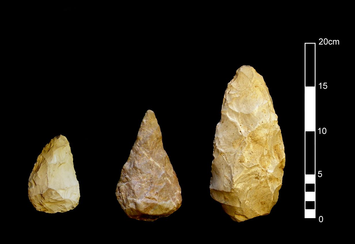
Confirm the extent and nature of early hominin activity during Period 4 (Mousterian)
Summary:
The East Midlands is one of few areas of Britain to have yielded a dataset for this period, albeit acquired principally by antiquarian explorations of limestone caves to the north and west of the region, and has significant potential for elucidating this poorly known period of prehistory[16]. Classic Mousterian bout coupé axes[17] have been recovered from a variety of contexts, including examples from the ploughzone at Harlaxton and below blown sand at Risby Warren[18] and a recently identified surface find from Marston Trussell[19]. The most extensive collection of Mousterian artefacts, however, remains that found during investigations of caves flanking the limestone gorge at Creswell Crags[20]. Further studies of extant artefact and faunal collections are recommended, particularly those recovered from Creswell Crags[21], plus targeted excavations of sites likely to preserve significant stratified deposits with associated artefacts and environmental remains. Faunal or botanical data would sharpen our picture of the regional environment, which in Britain was characterised during this period by short, alternating, periods of cold and warm temperatures with rapid transitions and by dry open grasslands (the ‘Mammoth Steppe’)[22]. Caves and areas buried beneath scree deposits are particularly important for the preservation of in situ remains, and should be targeted for excavation[23]. The potential of lowland environments is exemplified outside the region by the remarkable collection of Mousterian artefacts and fauna recovered from a palaeochannel at Lynford in Norfolk[24] and the woolly rhinoceros remains recovered from Late Pleistocene sands and gravels at Whitemoor Haye in Staffordshire[25], and appropriate deposits should be identified and investigated prior to quarrying and other developments that might impact upon remains of Mousterian activity.
Further investigate Upper Palaeolithic open-air sites
Summary:

Recent archaeological investigations in the region have located several nationally important open-air sites dating from the Early and Late Upper Palaeolithic[26]. Further prospection and analysis is recommended to elucidate their character, spatial distribution and topographic settings, including assessment of the most appropriate fieldwalking and test-pitting methods. Key sites include an Early Upper Palaeolithic open-air site and hyaena den at Glaston[27] and in situ concentrations of Creswellian (Late Magdalenian) flintwork and debitage on a river terrace at Farndon Fields near Newark[28], an in situ Creswellian lithic scatter found eroding out of a path in Bradgate Park near Leicester[29] and an extensive in situlong-blade assemblage at Launde, Leicestershire[30]. These sites represent the open-air equivalents of the Derbyshire and Nottinghamshire cave sites (Objective 1E), and analyses of lithic artefacts from the ploughzone and buried contexts may shed important light upon hunter-gatherer movements (Objective 1F) and in particular the relationship between open-air and cave locations. Trace element analysis of flints from Farndon Fields, for example, indicates that at least some of the material may have derived from a source over 200km to the south, which has profound implications for the reconstruction of mobility patterns. Along with other Creswellian open-air and cave sites, this campsite may have formed part of an annual subsistence round extending southwards to the Severn basin and northwards to Creswell Crags and other sites on the Magnesian Limestone escarpment[31].
Investigate Upper Palaeolithic use of the limestone caves of Derbyshire and Nottinghamshire
Summary:
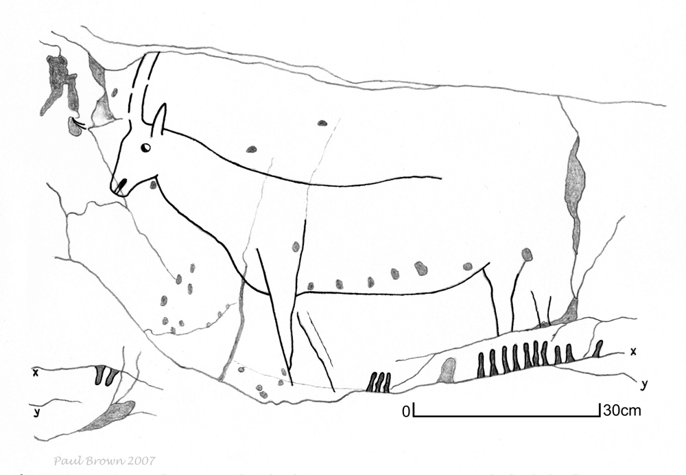
The caves and rock shelters of the Magnesian and Carboniferous limestones of Derbyshire and Nottinghamshire preserve a nationally important Palaeolithic resource – most spectacularly at Creswell Crags, which in addition to the first parietal artwork in Britain (including engravings of bison, deer, horses and birds in Church Hole Cave) has yielded the most northerly Early Upper Palaeolithic lithic artefacts in Britain[32]. Investigations in talus accumulations below Church Hole have revealed a hitherto unknown cave/rock shelter with stratified Creswellian lithic artefacts and an abundant fauna, including horse, reindeer, arctic hare and collared lemming[33], and emphasise the potential for preservation of other unexplored caves beneath slope deposits in limestone gorges within the region. Such caves may preserve crucial artefact evidence for Upper Palaeolithic activity and may shed important light upon the Early to Late Upper Palaeolithic cultural succession. Continued prospection for Upper Palaeolithic cave sites is recommended along the Magnesian Limestone escarpment of the Derbyshire-Nottinghamshire border and in the Carboniferous Limestone of the White Peak[34][35][36], combined with targeted investigations of selected sites. Environmental records for this period remain sparse, and caves with stratified deposits provide important opportunities for the preservation of fauna, pollen and other remains that may elucidate variations in environmental conditions across the region and over time[37].
Investigate the annual patterns of movement of Late Upper Palaeolithic hunter-gatherers
Summary:

The wide variety of evidence from the East Midlands for Late Upper Palaeolithic activity, including open-air sites[38], caves and rock shelters[39], raises the possibility of exploring settlement patterns, mobility and hunting strategies in ways that are possible in few other regions of the country. Systematic studies of Late Upper Palaeolithic lithic artefact morphology and technology could usefully be combined with scientific analyses aimed at establishing the potential sources of raw materials. Current collaborative work by the University of Sheffield and the British Geological Survey on artefact sourcing by trace element analyses of worked stone and potential source materials is of particular interest in this respect, and analyses at Farndon[40] and elsewhere have identified possible linkages between sites distributed widely over the Trent and Severn catchments and beyond[41][42]. Trace element analysis may well be useful as a technique for unravelling the annual patterns of movement of hunter-gatherers within and beyond the East Midlands, and could potentially be extended to sites of the Early Upper Palaeolithic and other periods where we can be confident that the observed pattern of finds reflects the original distribution of activity foci. This technique might be augmented by isotopic studies of human bone to elucidate the movement of people and their diets, and of animal bone to shed light upon their migration routes[43].
Elucidate from terrestrial sources the changing Pleistocene environment of the East Midlands
Summary:

Image 6-1B The Pre-Anglian Bytham and Ancaster river systems
Further mapping and visualisation of the Pleistocene landscape is recommended in order to elucidate further the relationship between human populations and changes in climate, vegetation and landscape[44]. This should be accompanied by the inclusion of further detail in Historic Environment Records, which at present often lack necessary information on the Pleistocene environment. There is significant scope in the East Midlands for further investigation of the changing environment, especially from the evidence of palaeochannels[45] and deposits in limestone caves[46]. Unpublished archive information from Creswell Crags has particular potential for elucidating changes in the Pleistocene environment, and merits further study in combination with excavations of in situ deposits[47]. Organic deposits associated with the Bytham drainage system also provide a critical resource for reconstructing the environment of the earliest hominin colonisers, as demonstrated by the discovery of organic remains associated with temperate deposits at Brooksby Quarry in Leicestershire[48] and by discoveries of organic deposits and associated cultural remains from sites distributed widely across the Midlands and eastern England[49].
Explore the submerged Pleistocene landscapes of Doggerland
Summary:

Sea-level rises between around 13,000 and 7500 years ago, following the melting of ice sheets after the Last Glacial Maximum, have inundated vast tracts of the low-lying plains that for much of the Pleistocene and early Holocene would have extended from eastern England to the Continent. Some 23,000 square kilometres of this submerged landscape, known as Doggerland, have been mapped as part of the North Sea Palaeolandscapes Project, revealing through 3D seismic data a striking image of a lowland landscape subject to continuous and dynamic change[50]. Large areas of the North Sea floor are the products of sediment reworking following submergence of low-lying areas, and may in many places seal preserved Pleistocene and early Holocene landscapes[51]. Seismic interpretation techniques have permitted the identification of buried river channels with the potential for preservation of cultural and environmental remains that may elucidate landscape developments and changing lifestyles – both in the Palaeolithic and Mesolithic (Objective 2H). For both periods, therefore, there is a clear need to identify, target, date and sample submarine palaeochannels and pre-inundation land surfaces, and to record and date artefact, faunal and botanical material retrieved principally through dredging[52]. There is also an opportunity to recover palaeoenvironmental data and artefacts from the assessment and development of further wind-farm locations[53], and from continuing liaison with the fishing industry.
| 1A | 1B | 1C | 1D | 1E | 1F | 1G | 1H |
Strategic Objective 1A
Refine knowledge of the earliest hominin activity in the region (pre-Anglian: Cromerian complex of Period 1)
The East Midlands is located astride the former Bytham River, which prior to obliteration of established drainage networks by the Anglian glaciation around 425,000 years ago would have flowed eastwards towards East Anglia[3], and hence is critically situated to provide information relating to the earliest (pre-Anglian) hominin activity in Britain[4]. It is recommended that wherever possible resources be focused during developer-funded work upon the identification and characterisation of cultural remains contained within deposits associated with the Bytham River[5][6] and with more northerly pre-Anglian rivers (including precursors of the Trent, Witham and Humber[7]). This should enhance studies of the distribution and character of early hominin activity, including migration routes, and might identify distinctions within artefact assemblages that could elucidate spatial and chronological variability. Fieldwork should also focus upon the retrieval of associated organic remains with the aim of elucidating the variety of ecological zones exploited by early hunter-gatherers (see Objective 1G). Valuable guidelines for Palaeolithic prospection have been provided by Collcutt[8], the 2008 Research and Conservation Framework for the British Palaeolithic and Buteux et al[9], and together these provide a sound basis for research projects aimed at synthesising current evidence and prospecting for additional data.
Agenda topics addressed: 1.1.1-1.1.3; 1.1.5, 1.5.1-1.5.3; 1.6.2; 1.6.4; 1.6.5
Archaeology of the East Midlands: 41
Other research frameworks:
Research and Conservation Framework for the British Palaeolithic 2008: Primary Research Themes 1 (Hominin environments and climate drivers) and 2 (Hominin demographies); Strategic Research/Conservation Theme 1 (Areas)
EH Research Strategy for Prehistory 2011: Theme PR1, Topic 9 (Reconstructing Pleistocene and Early Holocene landscapes)
References:
[#3] Rose, J 2009 ‘Early and Middle Pleistocene landscapes of eastern England’. Proceedings of the Geologists’ Association 120, 3-33
[#4] Buteux, S Chambers, J and Silva, B (eds) 2009 Digging Up the Ice Age. Oxford: Archaeopress, 32-36
[#5] Graf, A 2002 ‘Lower and Middle Palaeolithic Leicestershire and Rutland: Progress and potential’. Transactions of the Leicestershire Archaeological and Historical Society 76, 1-46
[#6] eg Jarvis, W, Cooper, L and Beamish, M 2010 ‘Brooksby Quarry, Melton Road, Brooksby’. Transactions of the Leicestershire Archaeological and Historical Society 84, 349-350; Stephens, M, Challis, K, Cooper, L et al 2008 ‘New exposure of the Bytham River deposits at Brooksby, Leicestershire: Context and importance’. Quaternary Newsletter 115, 14-27
[#7] eg White, T S, Bridgland, D R and Howard, A J 2007 ‘East Leake Quarry’ in White, T S, Bridgland, D R and Howard, A J et al (eds) 2007 The Quaternary of the Trent Valley and Adjoining Regions: Field Guide. London: Quaternary Research Association, 84-87
[#8] Collcutt, S 2006 Palaeolithic prospection: Some simple guidelines in The Archaeology of the East Midlands, 46-49
[#9] Buteux et al (eds) 2009, 111-120
The Pre-Anglian Bytham and Ancaster river systems (Rose 2009 Fig 21; reproduced by permission of the Geologists` Association and Jim Rose)
Summary:
The East Midlands is located astride the former Bytham River, which prior to obliteration of established drainage networks by the Anglian glaciation around 425,000 years ago would have flowed eastwards towards East Anglia[3], and hence is critically situated to provide information relating to the earliest (pre-Anglian) hominin activity in Britain[4]. It is recommended that wherever possible resources be focused during developer-funded work upon the identification and characterisation of cultural remains contained within deposits associated with the Bytham River[5][6] and with more northerly pre-Anglian rivers (including precursors of the Trent, Witham and Humber[7]). This should enhance studies of the distribution and character of early hominin activity, including migration routes, and might identify distinctions within artefact assemblages that could elucidate spatial and chronological variability. Fieldwork should also focus upon the retrieval of associated organic remains with the aim of elucidating the variety of ecological zones exploited by early hunter-gatherers (see Objective 1G). Valuable guidelines for Palaeolithic prospection have been provided by Collcutt[8], the 2008 Research and Conservation Framework for the British Palaeolithic and Buteux et al[9], and together these provide a sound basis for research projects aimed at synthesising current evidence and prospecting for additional data.
Agenda topics addressed: 1.1.1-1.1.3; 1.1.5, 1.5.1-1.5.3; 1.6.2; 1.6.4; 1.6.5
Archaeology of the East Midlands: 41
Other research frameworks:
Research and Conservation Framework for the British Palaeolithic 2008: Primary Research Themes 1 (Hominin environments and climate drivers) and 2 (Hominin demographies); Strategic Research/Conservation Theme 1 (Areas)
EH Research Strategy for Prehistory 2011: Theme PR1, Topic 9 (Reconstructing Pleistocene and Early Holocene landscapes)
References:
[#3] Rose, J 2009 ‘Early and Middle Pleistocene landscapes of eastern England’. Proceedings of the Geologists’ Association 120, 3-33
[#4] Buteux, S Chambers, J and Silva, B (eds) 2009 Digging Up the Ice Age. Oxford: Archaeopress, 32-36
[#5] Graf, A 2002 ‘Lower and Middle Palaeolithic Leicestershire and Rutland: Progress and potential’. Transactions of the Leicestershire Archaeological and Historical Society 76, 1-46
[#6] eg Jarvis, W, Cooper, L and Beamish, M 2010 ‘Brooksby Quarry, Melton Road, Brooksby’. Transactions of the Leicestershire Archaeological and Historical Society 84, 349-350; Stephens, M, Challis, K, Cooper, L et al 2008 ‘New exposure of the Bytham River deposits at Brooksby, Leicestershire: Context and importance’. Quaternary Newsletter 115, 14-27
[#7] eg White, T S, Bridgland, D R and Howard, A J 2007 ‘East Leake Quarry’ in White, T S, Bridgland, D R and Howard, A J et al (eds) 2007 The Quaternary of the Trent Valley and Adjoining Regions: Field Guide. London: Quaternary Research Association, 84-87
[#8] Collcutt, S 2006 Palaeolithic prospection: Some simple guidelines in The Archaeology of the East Midlands, 46-49
[#9] Buteux et al (eds) 2009, 111-120
Test the hypothesis that hominines may have been absent from the East Midlands during Period 2 (Pre-Levallois Lower Palaeolithic)
Summary:
Despite abundant data from southern England[10], convincing evidence for hunter-gatherer activity in the East Midlands following retreat of the Anglian ice remains elusive[11]. Hominines are known to have exploited more southerly river valleys and other ecological zones during temperate stages of Period 2, including the Thames and East Anglia[12], and unless movements were impeded by obstacles such as the deep fjord-like feature into which the Nene flowed near Peterborough[13] there seems no reason why the East Midlands should not also have attracted the attention of hunter-gatherers. Assessment of the extent of Period 2 hominin activity in the region is frustrated by an absence of evidence for deposits that may be dated securely to between late MIS12 and early MIS8[14]. It is recommended, therefore, that priority be accorded to the identification of deposits attributable to temperate stages of this period[15], followed by prospection for associated cultural material. This could be achieved by ensuring that the potential for the preservation of Period 2 deposits is established at an early stage of quarry developments across the region. The strategy should aim to confirm the presence or absence of Period 2 deposits, and, if these are found to be present, evaluate the potential for evidence of hominin activity.
Agenda topics addressed: 1.2.1; 1.2.4; 1.6.2; 1.6.4; 1.6.5
Archaeology of the East Midlands: 41
Other research frameworks:
Research and Conservation Framework for the British Palaeolithic 2008: Primary Research Theme 2 (Hominin demographies); Strategic Research/Conservation Theme 2 (Understanding the Record)
EH Research Strategy for Prehistory 2011: Theme PR1, Topic 9 (Reconstructing Pleistocene and Early Holocene landscapes)
References:
[#10] Scott, B 2011 Becoming Neanderthals. The Earlier British Middle Palaeolithic. Oxford: Oxbow Books
[#11] McNabb, J 2006 ‘The Palaeolithic’ in The Archaeology of the East Midlands, 22-24.
[#12] e.g. Schreve, D C, Bridgland, D R, Allen, P et al 2002 ‘Sedimentology, palaeontology and archaeology of late Middle Pleistocene River Thames terrace deposits at Purfleet, Essex, UK’. Quaternary Science Review 21, 1423-146
[#13] McNabb 2006, 24
[#14] Although identified on the fringe of our area at, for example, Peterborough and near Stoke Goldington, Buckinghamshire: McNabb 2006, 24
[#15] Compare Howard, A J and Knight, D 2004 ‘The Pleistocene Background’ in Knight, D and Howard, A J Trent Valley Landscapes. Kings Lynn: Heritage Marketing & Publications, 15
Confirm the extent and nature of early hominin activity during Period 4 (Mousterian)
Summary:
The East Midlands is one of few areas of Britain to have yielded a dataset for this period, albeit acquired principally by antiquarian explorations of limestone caves to the north and west of the region, and has significant potential for elucidating this poorly known period of prehistory[16]. Classic Mousterian bout coupé axes[17] have been recovered from a variety of contexts, including examples from the ploughzone at Harlaxton and below blown sand at Risby Warren[18] and a recently identified surface find from Marston Trussell[19]. The most extensive collection of Mousterian artefacts, however, remains that found during investigations of caves flanking the limestone gorge at Creswell Crags[20]. Further studies of extant artefact and faunal collections are recommended, particularly those recovered from Creswell Crags[21], plus targeted excavations of sites likely to preserve significant stratified deposits with associated artefacts and environmental remains. Faunal or botanical data would sharpen our picture of the regional environment, which in Britain was characterised during this period by short, alternating, periods of cold and warm temperatures with rapid transitions and by dry open grasslands (the ‘Mammoth Steppe’)[22]. Caves and areas buried beneath scree deposits are particularly important for the preservation of in situ remains, and should be targeted for excavation[23]. The potential of lowland environments is exemplified outside the region by the remarkable collection of Mousterian artefacts and fauna recovered from a palaeochannel at Lynford in Norfolk[24] and the woolly rhinoceros remains recovered from Late Pleistocene sands and gravels at Whitemoor Haye in Staffordshire[25], and appropriate deposits should be identified and investigated prior to quarrying and other developments that might impact upon remains of Mousterian activity.
Agenda topics addressed: 1.3.1-1.3.4; 1.5.2-1.5.3; 1.6.2; 1.6.4; 1.6.5
Archaeology of the East Midlands: 42, 264
Other research frameworks:
Research and Conservation Framework for the British Palaeolithic 2008: Primary Research Theme 2 (Hominin demographies); Strategic Research/Conservation Themes 1 (Areas) and 2 (Understanding the record)
EH Research Strategy for Prehistory 2011: Themes PR1, Topic 9 (Reconstructing Pleistocene and Early Holocene landscapes), PR2, Topic 13 (Understanding and protecting prehistoric caves, rock shelters and mines) and PR 3, Topic 18 (Technology and society in prehistory)
Research Framework for the Archaeology and Palaeontology of Creswell Crags and the Limestone Heritage Area 2010: Section 6.2
References:
[#16] McNabb, J 2006 ‘The Palaeolithic’ in Archaeology of the East Midlands, 29-31; White, M J and Pettitt, P B 2011 ‘The British Middle Palaeolithic. An interpretative synthesis of Neanderthal occupation at the north-western edge of the Pleistocene World’. Journal of World Prehistory 24, 25-97
[#17] Roe, D A, 1981 The Lower and Middle Palaeolithic Periods in Britain. London: RKP, 240-267; White, M J and Jacobi, R M 2003 ‘Two sides to every story: Bout coupé handaxes revisited’. Oxford Journal of Archaeology 21, 109-133
[#18] Harlaxton, Lincolnshire and Risby Warren, Lincolnshire: Roe 1981, 261-62
[#19] Marston Tressell, Northamptonshire: McNabb 2006, 31
[#20] Jenkinson, R D S 1984 Creswell Crags: Late Pleistocene Sites in the East Midlands (British Archaeological Reports British Series 122). Oxford: B.A.R ; Pettitt, P B and Jacobi, R M 2009 ‘The archaeology of Creswell Crags’ in Bahn, P and Pettitt, P B (eds) Britain’s Oldest Art: The Ice Age Art of Creswell Crags. London: English Heritage, 16-35
[#21] Wall, I and Jacobi, R M 2000 An Assessment of the Pleistocene Collections from the Cave and Rock Shelter Sites in the Creswell Area. Creswell Heritage Trust (http://archaeologydataservice.ac.uk/archives/view/creswellcrags_eh_2006/)
[#22] McNabb 2006, 31
[#23] Pettitt, P B, Jacobi, R M, Chamberlain, A T et al 2009 ‘Excavations outside Church Hole, Creswell Crags: The first three seasons (2006-8)’. Transactions of the Thoroton Society 113, 35-53
[#24] Research and Conservation Framework for the British Palaeolithic 2008, 17
[#25] Schreve, D C, Howard, A J, Currant, A P et al 2012 ‘A Middle Devensian woolly rhinoceros (Coelodonta antiquitatis) from Whitemoor Haye Quarry, Staffordshire (UK): Palaeoenvironmental context and significance’. Journal of Quaternary Science 28, 118-130
Further investigate Upper Palaeolithic open-air sites
Summary:
Recent archaeological investigations in the region have located several nationally important open-air sites dating from the Early and Late Upper Palaeolithic[26]. Further prospection and analysis is recommended to elucidate their character, spatial distribution and topographic settings, including assessment of the most appropriate fieldwalking and test-pitting methods. Key sites include an Early Upper Palaeolithic open-air site and hyaena den at Glaston[27] and in situ concentrations of Creswellian (Late Magdalenian) flintwork and debitage on a river terrace at Farndon Fields near Newark[28], an in situ Creswellian lithic scatter found eroding out of a path in Bradgate Park near Leicester[29] and an extensive in situlong-blade assemblage at Launde, Leicestershire[30]. These sites represent the open-air equivalents of the Derbyshire and Nottinghamshire cave sites (Objective 1E), and analyses of lithic artefacts from the ploughzone and buried contexts may shed important light upon hunter-gatherer movements (Objective 1F) and in particular the relationship between open-air and cave locations. Trace element analysis of flints from Farndon Fields, for example, indicates that at least some of the material may have derived from a source over 200km to the south, which has profound implications for the reconstruction of mobility patterns. Along with other Creswellian open-air and cave sites, this campsite may have formed part of an annual subsistence round extending southwards to the Severn basin and northwards to Creswell Crags and other sites on the Magnesian Limestone escarpment[31].
Agenda topics addressed: 1.4.1-1.4.6; 1.4.8; 1.5.2; 1.5.3; 1.6.1; 1.6.2
Archaeology of the East Midlands: 42
Other research frameworks:
Research and Conservation Framework for the British Palaeolithic 2008: Primary Research Theme 3 (How we became human); Strategic Research/Conservation Themes 1 (Areas) and 2 (Understanding the record)
EH Research Strategy for Prehistory 2011: Theme PR2, Topic 14 (Understanding and protecting ‘sites without structures’)
Research Framework for the Archaeology and Palaeontology of Creswell Crags and the Limestone Heritage Area 2010, Sections 6.1.6 and 6.2.7
References:
[#26] McNabb, J 2006 ‘The Palaeolithic’ in The Archaeology of the East Midlands, 36; 39-41
[#27] Cooper, L P, Thomas, J S, Beamish, M G et al 2012 ‘An Early Upper Palaeolithic open-air station and mid-Devensian hyaena den at Grange Farm, Glaston, Rutland, UK’. Proceedings of the Prehistoric Society 78, 79-93
[#28] Garton, D and Jacobi, R M 2009 ‘An extensive Late Upper Palaeolithic flint scatter at Farndon Fields, near Newark, Notts’. Archaeological Journal 166, 1-37
[#29] Cooper, L P 2002 ‘A Creswellian campsite, Newtown Linford’. Transactions of the Leicestershire Archaeological and Historical Society 73, 91-97
[#30] Cooper, L P 2006 ‘Launde, a Terminal Palaeolithic campsite in the English Midlands and its Northern European context’. Proceedings of the Prehistoric Society 72, 53-93
[#31] Pettitt, P B 2008 ‘The British Upper Palaeolithic’ in Pollard, J (ed) Prehistoric Britain. Oxford: Blackwell, 41-42, Fig 2.10
Investigate Upper Palaeolithic use of the limestone caves of Derbyshire and Nottinghamshire
Summary:
The caves and rock shelters of the Magnesian and Carboniferous limestones of Derbyshire and Nottinghamshire preserve a nationally important Palaeolithic resource – most spectacularly at Creswell Crags, which in addition to the first parietal artwork in Britain (including engravings of bison, deer, horses and birds in Church Hole Cave) has yielded the most northerly Early Upper Palaeolithic lithic artefacts in Britain[32]. Investigations in talus accumulations below Church Hole have revealed a hitherto unknown cave/rock shelter with stratified Creswellian lithic artefacts and an abundant fauna, including horse, reindeer, arctic hare and collared lemming[33], and emphasise the potential for preservation of other unexplored caves beneath slope deposits in limestone gorges within the region. Such caves may preserve crucial artefact evidence for Upper Palaeolithic activity and may shed important light upon the Early to Late Upper Palaeolithic cultural succession. Continued prospection for Upper Palaeolithic cave sites is recommended along the Magnesian Limestone escarpment of the Derbyshire-Nottinghamshire border and in the Carboniferous Limestone of the White Peak[34][35][36], combined with targeted investigations of selected sites. Environmental records for this period remain sparse, and caves with stratified deposits provide important opportunities for the preservation of fauna, pollen and other remains that may elucidate variations in environmental conditions across the region and over time[37].
Agenda topics addressed: 1.4.1-1.4.8; 1.5.2; 1.5.3; 1.6.2
Archaeology of the East Midlands: 42, 264
Other research frameworks:
Research and Conservation Framework for the British Palaeolithic 2008: Primary Research Theme 3 (How we became human); Strategic Research/Conservation Theme 3 (Dating frameworks)
EH Research Strategy for Prehistory 2011: Theme PR2, Topic 13 (Understanding and protecting prehistoric caves, rock shelters and mines) Research Framework for the Archaeology and Palaeontology of Creswell Crags and the Limestone Heritage Area 2010: Section 6.2
EH National Heritage Science Strategy Report 2, 2009: Section 3.3.1 (People and the environment)
References:
[#32] Bahn, P and Pettitt, P B 2009 Britain’s Oldest Art: The Ice Age Cave Art of Creswell Crags. London: English Heritage; Jenkinson, R D S 1984 Creswell Crags: Late Pleistocene Sites in the East Midlands (British Archaeological Reports British Series 122). Oxford: B.A.R; Pettitt, P B, Bahn, P and Ripoll, S (eds) 2007 Palaeolithic Cave Art at Creswell Crags in European Context. Oxford: Oxford University Press
[#33] Pettitt, P B, Jacobi, R M, Chamberlain, A T et al 2009 ‘Excavations outside Church Hole, Creswell Crags; The first three seasons (2006-8)’. Transactions of the Thoroton Society 113, 35-53
[#34] Chamberlain, A T 2007 ‘Cave archaeology and palaeontology in the Creswell region’ in Pettitt, P B et al (eds) 2007, 61-70
[#35] Holderness, H, Davies, G, Chamberlain, A T et al 2006 A Conservation Audit of Archaeological Cave Resources in the Peak District and Yorkshire Dales (ARCUS Research Report 743b). Sheffield: University of Sheffield
[#36] Davies, G, Badcock, A, Mills, N and Smith, B 2004 Creswell Crags Limestone Heritage Area Management Plan (ARCUS Research Report 719b). Sheffield: University of Sheffield
[#37] Charles, R and Jacobi, R 1994 ‘The Late Glacial fauna from the Robin Hood Cave, Creswell Crags: A re-assessment’. Oxford Journal of Archaeology 13, 1-32
Investigate the annual patterns of movement of Late Upper Palaeolithic hunter-gatherers
Summary:
The wide variety of evidence from the East Midlands for Late Upper Palaeolithic activity, including open-air sites[38], caves and rock shelters[39], raises the possibility of exploring settlement patterns, mobility and hunting strategies in ways that are possible in few other regions of the country. Systematic studies of Late Upper Palaeolithic lithic artefact morphology and technology could usefully be combined with scientific analyses aimed at establishing the potential sources of raw materials. Current collaborative work by the University of Sheffield and the British Geological Survey on artefact sourcing by trace element analyses of worked stone and potential source materials is of particular interest in this respect, and analyses at Farndon[40] and elsewhere have identified possible linkages between sites distributed widely over the Trent and Severn catchments and beyond[41][42]. Trace element analysis may well be useful as a technique for unravelling the annual patterns of movement of hunter-gatherers within and beyond the East Midlands, and could potentially be extended to sites of the Early Upper Palaeolithic and other periods where we can be confident that the observed pattern of finds reflects the original distribution of activity foci. This technique might be augmented by isotopic studies of human bone to elucidate the movement of people and their diets, and of animal bone to shed light upon their migration routes[43].
Agenda topics addressed: 1.4.2-1.4.5; 1.6.1
Archaeology of the East Midlands: 42
Other research frameworks:
Research and Conservation Framework for the British Palaeolithic 2008: Primary Research Theme 3 (How we became human); Strategic Research/Conservation Theme 2 (Understanding the record)
EH Research Strategy for Prehistory 2011: Theme PR1, Topic 9 (Reconstructing Pleistocene and Early Holocene landscapes); Theme PR3, Topic 17 (Technology and society in prehistory); Theme PR5, Topic 27 (Developing scientific techniques for prehistory)
Research Framework for the Archaeology and Palaeontology of Creswell Crags and the Limestone Heritage Area 2010: Section 6.1.6
EH National Heritage Science Strategy Report 2, 2009: Section 3.4.1 (Understanding materials)
References:
[#38] eg Garton, D and Jacobi, R M 2009 ‘An extensive Late Upper Palaeolithic flint scatter at Farndon Fields, near Newark, Nottinghamshire’. Archaeological Journal 166, 1-37
[#39] eg Creswell Crags: Bahn, P and Pettitt, P B 2009 Britain’s Oldest Art: The Ice Age Cave Art of Creswell Crags. London: English Heritage; Jenkinson, R D S 1984 Creswell Crags: Late Pleistocene Sites in the East Midlands (British Archaeological Reports British Series 122). Oxford: B.A.R; Pettitt, P B Bahn, P and Ripoll, S (eds) 2007 Palaeolithic Cave Art at Creswell Crags in European Context. Oxford: Oxford University Press.
[#40] Garton and Jacobi 2009
[#41] Pettitt, P B 2008 ‘The British Upper Palaeolithic’ in Pollard, J (ed) Prehistoric Britain. Oxford: Blackwell, 41-43
[#42] Rockman, M 2003 ‘Landscape Learning in the Late Glacial Recolonization of Britain’. Unpublished PhD dissertation, University of Arizona
[#43] EH National Heritage Science Strategy Report 2 2009, 10
Elucidate from terrestrial sources the changing Pleistocene environment of the East Midlands
Summary:
Image 6-1B The Pre-Anglian Bytham and Ancaster river systems
Further mapping and visualisation of the Pleistocene landscape is recommended in order to elucidate further the relationship between human populations and changes in climate, vegetation and landscape[44]. This should be accompanied by the inclusion of further detail in Historic Environment Records, which at present often lack necessary information on the Pleistocene environment. There is significant scope in the East Midlands for further investigation of the changing environment, especially from the evidence of palaeochannels[45] and deposits in limestone caves[46]. Unpublished archive information from Creswell Crags has particular potential for elucidating changes in the Pleistocene environment, and merits further study in combination with excavations of in situ deposits[47]. Organic deposits associated with the Bytham drainage system also provide a critical resource for reconstructing the environment of the earliest hominin colonisers, as demonstrated by the discovery of organic remains associated with temperate deposits at Brooksby Quarry in Leicestershire[48] and by discoveries of organic deposits and associated cultural remains from sites distributed widely across the Midlands and eastern England[49].
Agenda topics addressed: 1.5.1-1.5.3; 1.6.4; 1.6.5
Archaeology of the East Midlands: 41-42, 264
SHAPE 2008: Understand the impact of past climate change (11111.410); Understanding ancient environments and ecologies (11111.420)
NHPP 2011: Deeply buried/subterranean Pleistocene and Early Holocene archaeology (3A3); Identification of wetland/waterlogged sites (3A5); Pleistocene and Early Holocene archaeology (4G1); Enhancing the capabilities of HER Records (5C1)
Other research frameworks:
Research and Conservation Framework for the British Palaeolithic 2008: Primary Research Theme 1 (Hominin environments and climate drivers); Strategic Research/Conservation Theme 1 (Areas)
EH Research Strategy for Prehistory 2011: Theme PR6, Topics 30 (Human responses to environmental change in prehistory) and 31 (Human interactions with plants and animals); Theme PR8, Topic 42 (Making HERs and related sources more accurate, relevant and useful for prehistory)
Research Framework for the Archaeology and Palaeontology of Creswell Crags and the Limestone Heritage Area 2010: especially Sections 6.1.1, 6.1.4 & 6.2.1
EH National Heritage Science Strategy Report 2, 2009: Section 3.3.1 (People and the Environment)
References:
[#44] Monckton, A 2006 ‘Environmental archaeology in the East Midlands’ in The Archaeology of the East Midlands, 262-264
[#45] e.g. Howard, A J and Knight, D 2004 ‘The Pleistocene Background’ in Knight, D and Howard, A J 2004 Trent Valley Landscapes. Kings Lynn: Heritage Marketing and Publications, 12-23
[#46] Charles, R. and Jacobi, R 1994 ‘The Late Glacial fauna from the Robin Hood Cave, Creswell Crags: A re-assessment’. Oxford Journal of Archaeology 13, 1-32
[#47] Research Framework for the Archaeology and Palaeontology of Creswell Crags and the Limestone Heritage Area, Sections 6.1 and 6.2.2
[#48] Jarvis, W, Cooper, L and Beamish, M 2010 ‘Brooksby Quarry, Melton Road, Brooksby’. Transactions of the Leicestershire Archaeological and Historical Society 84, 349-350; Stephens, M, Challis, K, Cooper, L et al 2008 ‘New exposure of the Bytham River deposits at Brooksby, Leicestershire: Context and importance’. Quaternary Newsletter 115, 14-27
[#49] Rose, J 2009 ‘Early and Middle Pleistocene landscapes of eastern England’. Proceedings of the Geologists’ Association 120, 3-33
Explore the submerged Pleistocene landscapes of Doggerland
Summary:
Sea-level rises between around 13,000 and 7500 years ago, following the melting of ice sheets after the Last Glacial Maximum, have inundated vast tracts of the low-lying plains that for much of the Pleistocene and early Holocene would have extended from eastern England to the Continent. Some 23,000 square kilometres of this submerged landscape, known as Doggerland, have been mapped as part of the North Sea Palaeolandscapes Project, revealing through 3D seismic data a striking image of a lowland landscape subject to continuous and dynamic change[50]. Large areas of the North Sea floor are the products of sediment reworking following submergence of low-lying areas, and may in many places seal preserved Pleistocene and early Holocene landscapes[51]. Seismic interpretation techniques have permitted the identification of buried river channels with the potential for preservation of cultural and environmental remains that may elucidate landscape developments and changing lifestyles – both in the Palaeolithic and Mesolithic (Objective 2H). For both periods, therefore, there is a clear need to identify, target, date and sample submarine palaeochannels and pre-inundation land surfaces, and to record and date artefact, faunal and botanical material retrieved principally through dredging[52]. There is also an opportunity to recover palaeoenvironmental data and artefacts from the assessment and development of further wind-farm locations[53], and from continuing liaison with the fishing industry.
Agenda topics addressed: 1.4.4; 1.4.5; 1.5.1-1.5.3; 1.6.2; 1.6.3.
Other research frameworks:
Research and Conservation Framework for the British Palaeolithic 2008: Primary Research Theme 1 (Hominin environments and climate drivers); Strategic Research/Conservation Theme 1(Areas).
EH Research Strategy for Prehistory 2011: Theme PR1, Topic 8 (Submerged prehistoric landscapes); Theme PR6, Topic 30 (Human responses to environmental change in prehistory).
North Sea Prehistory Research and Management Framework 2009, 28: Themes B (Palaeogeography and environment) and G (Representation of prehistoric hunter-gatherer communities and lifeways).
Canti, M. 2009. A Review of Geoarchaeology in the Midlands of England. 55: Priority 3.2 (Marine sediments).
EH National Heritage Science Strategy Report 2, 2009: Section 3.5.1 (Detecting and imaging).
References:
[50] Coles, B J 1998 ‘Doggerland: A speculative survey’. Proceedings of the Prehistoric Society 64, 45-81; Gaffney, V, Fitch, S and Smith, D 2009 Europe’s Lost World: The Rediscovery of Doggerland (CBA Research Report 160). York: Council for British Archaeology
[51] Peeters, H, Murphy, P and Flemming, N, 2009 North Sea Prehistory Research and Management Framework, 19-24
[52] Peeters et al 2009, 28; building in the East Midlands upon current work carried out in the Humberside region and along the East Coast as part of the ALSF Regional Environmental Characterisation project (http://www.humberrecgis.org.uk/hu/)
[53] English Heritage 2005 Wind Energy and the Historic Environment. London: English Heritage