Click here to see how to contribute

Identify and research the landless urban and rural poor
Summary:

The landless poor, with few possessions and often inhabiting insubstantial structures, have left few traces in the archaeological or documentary record, and identification of this largely invisible social class has been highlighted as a key priority for research. Even in the nineteenth century, the rural poor are hard to see[1], and for the Post-Medieval period they are most clearly visible by inference – as carriers, for example, of night soil to the fields, or as protagonists in the 1607 Midlands Revolt and other civil unrests reflecting antagonism to enclosure of the medieval open fields[2][3]. Some of these communities are potentially identifiable in the countryside by small, irregular enclosures on the edges of pasture, wood or road, depicted but not remarked upon by the surveyors of tithe or enclosure maps and now worth surveying for insubstantial earthworks or particular colonies of plants that might betray flimsy dwellings and other structures[4]. Wastes and commons, identifiable from documentary and cartographic sources, also provide possible locations for squatter settlements that might be revealed by detailed field investigations[5]. In urban areas, investigations of vacant plots and open areas on the edges of settlement may also reveal insubstantial structures associated with the poor[6]. Related groups include gypsies and travellers, whose temporary encampments are sometimes known through tradition, along with itinerant charcoal burners, shepherds and herdsfolk. These settlement locations have seldom formed the focus of archaeological inquiry, and all are under pressure from intensifying agriculture, forestry and urban development.
Agenda topics addressed: 8.1.2; 8.1.5; 8.4.1; 8.4.4
Further research the morphology and use of caves
Summary:
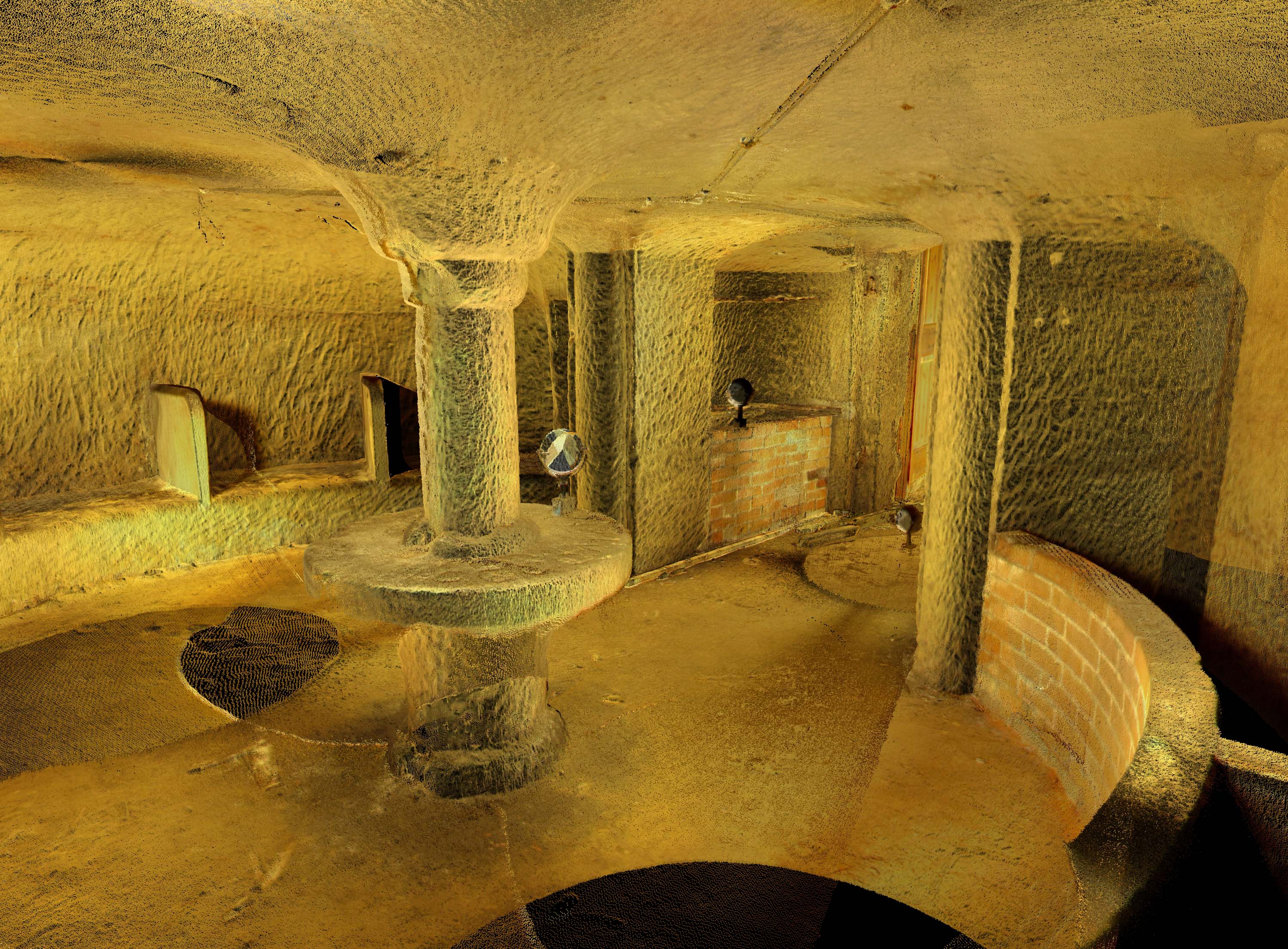
The East Midlands preserves significant evidence for Post-Medieval usage of caves, most notably at Nottingham. The soft sandstone which underlies the modern city preserves a remarkable collection of over 500 artificially created caves[7], many of which were utilised in the Post-Medieval period for purposes such as habitation, storage, malting and tanning[8]. Their chronology extends at least from medieval to modern times, when some caves were utilised as Second World War air-raid shelters[9], and this unique resource has been highlighted as a key priority for cross-period research. A detailed laser survey of the caves is currently being conducted by Trent & Peak Archaeology alongside an assessment of the documentary resource[10], and will provide a secure foundation for future management of the resource and further research (including analyses of finds obtained during unpublished excavations and integration of the evidence from subterranean and standing structures). Comparable surveys may usefully be extended to other caves in the region whose period of use may have spanned the Post-Medieval period. Artificial caves are a distinctive feature of sandstone outcrops elsewhere in the region, including the Anchor Church[11] near Foremark and the Hermit’s Cave near Dale Abbey[12], both in Derbyshire. In addition, natural caves with evidence for human activity spanning many millennia are abundantly distributed across the Carboniferous limestones of the Derbyshire Peak and the Magnesian Limestone escarpment that straddles the Derbyshire-Nottinghamshire boundary. A review of post-medieval use of the above sites would complement well the on-going work at Nottingham and would provide a useful basis for further survey work and assessments of caves used in the medieval and other periods.
Agenda topics addressed: 8.1.2; 8.1.6; 8.5.1
Establish a typology of regional building traditions
Summary:
Further research is recommended to establish a typology of regional vernacular buildings and to investigate temporal and spatial variations in building styles and materials (as indicated, for example, by the distinctive Lincolnshire tradition of mud or cob built structures with timber studs[13]). Dating is particularly problematic for many building types, and it is recommended that further use be made where possible of dendrochronological data – as, for example, in the recent exemplary studies of Newark and Norwell in Nottinghamshire[14]. Further information on the antecedents of post-medieval vernacular buildings could be obtained from the investigation of early structural remains concealed within gentrified urban buildings[15] and by the excavation of deserted or shrunken rural settlements. Reviews of vernacular architectural traditions tend to focus on extant higher status buildings[16], and survey could usefully be extended to the broad range of lower status structures that survive. A number of valuable sub-regional and local studies have been conducted[17], some such as the buildings survey published by the Norwell Parish Heritage Group[18] combining effectively the evidence of documents and maps with archaeological, dendrochronological and architectural information. These are complemented by the Buildings of England volumes, which include reviews of building styles and the range of building materials used[19], and in north Northamptonshire by a systematic RCHME survey of architectural monuments[20]. Themes which deserve greater consideration include the transformation of individual wealth as reflected in buildings, the impact of church ownership[21], the transition from timber-framed to brick or stone construction[22] and the study of local landscape settings[23].
Agenda topics addressed: 8.1.6; 8.2.5; 8.4.1-8.4.3; 8.5.3
Investigate developments in estate and garden design and their landscape context
Summary:

s south front (1687-89), overlooking the Canal Pond, dug in 1702. The pond was embellished in 1843 by Joseph Paxtons dramatic Emperor Fountain (photograph: Hannah Knight)The East Midlands preserves numerous estates where a grand mansion sits at the centre of a tract of private land[24], as for example at Chatsworth in Derbyshire[25][26]. The study of estates has often been polarised between social and art historic evaluation of the mansion house and agricultural and horticultural assessment of the estate. There has commonly been little attempt to link these approaches or to consider relationships with the wider landscape and with more distant but closely intertwined interests of the estate owner[27]. Williamson has identified three phases of estate development, embracing the Post-Medieval and Modern periods, and hence this Research Objective spans both of these periods[28]. The first of these phases spanned the mid-seventeenth to mid-eighteenth centuries, during which time some of the larger estates developed, sometimes on post-Dissolution sites. The second part of the eighteenth century saw the development of Neo-Classical mansions associated with private parks from which public roads and settlements had been diverted. A third phase may be identified in the early nineteenth century, and was based on the landscaping ideas of Humphrey Repton[29]. Estate design owed much to local topographic and landscape factors, as well as to local tenurial and social traditions. Regional and sub-regional characteristics should be identifiable[30] and study of these variations should be encouraged. Particular attention should be paid to the impact of other landholdings and economic interests such as mining upon estate design and management, and to the influence of large estates upon the numerous and less commonly researched small estates[31].
Agenda topics addressed: 8.2.1-8.2.5
Identify agricultural improvements of the sixteenth to eighteenth centuries
Summary:

Rockingham Forest. An Atlas of the Medieval and Early-Modern Landscape, 72. Northampton: Northampton Record Society XLIV; reproduced by permission of the authors, the Northamptonshire Record Society and the Rockingham Forest Trust)Enclosure of the open fields, waste and commons took place increasingly from the sixteenth century, along with reclamation of the Lincolnshire Fens[32] and other marshy areas and the development of water meadows, although physical evidence of these changes is not always clearly visible until the late eighteenth and early nineteenth centuries[33]. Additional investigations are required to shed further light upon the development of early enclosures, water meadows, fenland drainage schemes and other landscape evidence of the agricultural improvements that characterised this period[34] – and the extent of intra-regional variability. Environmental analyses of palaeobotanical and faunal assemblages should be encouraged as means of enhancing our knowledge of changes in crop and animal husbandry[35], including identification of the famously large sheep of the region that have so far eluded detection in archaeological excavations[36]. A variety of other direct and indirect evidence for agricultural improvement may also be expected, and should be sought for. The success of the Ticknall pottery in Derbyshire, for example, which produced substantial quantities of dairy ceramics throughout the seventeenth century in the face of Staffordshire competition[37], may reflect in part the growing importance and success of dairy farming in the region. Research should also be focused upon the identification of specialist agricultural buildings that may provide indirect evidence for agricultural change, such as beast houses which may reflect the growing importance of dairying and beef cattle production.
Agenda topics addressed: 8.3.1-8.3.4; 8.4.2; 8.4.5; 8.8.1

Research the development of East Midlands industry and its impact upon landscape and settlement morphology
Summary:

Coal mining has a long ancestry in the East Midlands, as demonstrated by this pattern of probably sixteenth century mine galleries that was exposed in the middle of the Lounge Opencast site near Coleorton, Leicestershire
Coal, lead, iron, leather-working and textile production were foremost among a number of industries which in the Post-Medieval period came to characterise the East Midlands[38], and in the case particularly of coal and lead may be regarded as of national importance. A key area of required research is the transition of industry from an adjunct of the agricultural economy to the economic driver of the rural economy and the stimulus for urbanisation[39]. Rural sources of industry require further assessment of their locations, as well as the recording of detail. Particular interest attaches to the extensive coal-mining remains of Derbyshire, Leicestershire and Nottinghamshire[40], the landscape evidence for which has yet to be fully identified and recorded. Linkage to efficient communications networks and labour resources played a key role in the development of the coal industry, but the scale and chronology of the extraction of coal and other materials also depended on tenurial arrangements and the availability of labour. Processing frequently took place within settlements, including cloth-making and framework-knitting in rural settlements and leather-tanning in urban locations. All of these activities, which required open space and separation from domestic settlement, influenced settlement morphology and would have spurred population growth and hence settlement expansion.[41][42]
Agenda topics addressed: 8.4.4; 8.5.1-8.5.6
Study the post-Dissolution re-use of monastic structures and the continuity of monastic estates
Summary:

The history of use of medieval monastic buildings and their estates following Henry VIII’s dissolution of the monasteries between 1536 and 1539[43] remains poorly known and would benefit from further investigation. Some monastic institutions were abandoned after the Dissolution[44], but many other monastic buildings were converted to dwellings or other uses[45]. The conversion from ecclesiastical to secular use is illustrated by virtually all of over one hundred monasteries in the diocese of Lincoln[46], and elsewhere in the region has been demonstrated by documentary research and fieldwork at former abbey sites such as Launde[47] and Leicester[48], and by a study of the buildings and gardens of the former monastic grange at Langtoft Hall Farm in Lincolnshire[49]. The Dissolution provided important opportunities for the acquisition of high-status buildings and for the transfer to secular hands of extensive, well-managed and wealthy monastic estates[50]. While there may have been little change in how the land was managed, many estates will have been sub-divided or amalgamated with other holdings. Such amendments should be visible in the components of the historic landscape, as well as in written records[51], and merit detailed study as important evidence for the development of patterns of land ownership in the post-Reformation rural landscape.
Agenda topics addressed: 8.6.1
Investigate graveyards and other burial sites
Summary:

Graveyards and other burials, including the mass graves that may survive at battlefield sites[52] and plague burial sites such as Eyam in Derbyshire[53] offer a wide range of information relating to demography, personal identity, religious observance and attitudes to death and, in the case of graveyards, the production, manufacture and acquisition of memorials[54]. Graveyards and the stones they contain are also an important ecological resource meriting conservation. Despite their importance, graveyard memorials are at significant risk, not only from erosion but also as a result of misdirected ‘tidying-up’ and clearance, perceived safety precautions and direct threats posed by the construction of amenities, and hence recording should be regarded as a priority before irreplaceable evidence is lost. Graveyards also offer a wide range of recording and interpretation opportunities which are particularly well-suited to community groups, and there is a need both to encourage such activities and to ensure a common approach so that comparable information can be retrieved from across the region[55][56].
Agenda topics addressed: 8.6.3; 8.7.1
Develop further the study of ceramic assemblages
Summary:

The region as a whole is poorly served by synthetic assessments of post-medieval ceramics, and although a number of key pottery groups from Nottingham, Leicester and elsewhere have been published[57] many important assemblages await full analysis and publication[58]. The development of ceramic studies needs to be underpinned by stronger guidance on methodologies to be employed during excavation, fieldwalking and post-survey analysis, and by the establishment of a regional ceramic type-series that will facilitate comparison and analysis of pottery and other ceramic artefacts and refine our understanding of ceramic chronology. Particular areas of inquiry, which should be addressed in further appraisals of ceramic assemblages, include the distribution of imported and other high-status pottery as an indicator of developing communications routes and patterns of changing status, diet and fashion[59]. Studies of individual assemblages which offer the chance to contribute to biographies of households and individuals should be encouraged, while the retrieval and study of assemblages from deserted villages and other rural sites should also be promoted. Ceramic analyses may also contribute to studies of agricultural improvements, as demonstrated by the proposed link between the successful marketing of Ticknall Ware and an expansion of dairy farming in the region (Objective 8E)[60].
Agenda topics addressed: 8.2.4; 8.8.1-8.8.5
Investigate Civil War defences, siege works and battlefields
Summary:

The East Midlands was an important arena of conflict during the First (1642-1646) and Second (1648) Civil Wars[61], and this turbulent period saw the fortification of key towns such as Leicester, Nottingham and Northampton and some of its gentry houses[62]. The region preserves several battlefield and siege sites of national importance, including the decisive Battle of Naseby (1645)[63] and the remarkable complex of siege works encircling Newark-on-Trent[64], plus many other skirmish, battle and siege sites. Many of these are vulnerable to development and require the formulation of appropriate conservation and management strategies. There is an urgent need for an assessment of the survival and condition of structural remains at siege sites, together with a separate assessment of the taphonomy of battle archaeology to determine the factors determining the survival and condition of metal artefact scatters. These could provide a foundation for subsequent investigation by a combination of metal detector survey, remote sensing, excavation, documentary and topographic work. Appropriate methodologies have been developed at Naseby[65] and several other sites in the region, including Leicester[66] and Grafton Regis[67] in Northamptonshire, and should be extended to other sites in the region. Newark, with its exceptional system of preserved offensive and defensive monuments, stands out as an ideal focus for further study, which could build upon the excellent survey conducted by the Royal Commission[68] and more recent work associated with the Monuments Protection Programme[69]. Building particularly upon the experience of work carried out at Bosworth (Objective 7H), there is also significant scope for community involvement.
Agenda topics addressed: 8.7.1-8.7.3
Strategic Objective 8A
Identify and research the landless urban and rural poor
Summary:
The landless poor, with few possessions and often inhabiting insubstantial structures, have left few traces in the archaeological or documentary record, and identification of this largely invisible social class has been highlighted as a key priority for research. Even in the nineteenth century, the rural poor are hard to see[1], and for the Post-Medieval period they are most clearly visible by inference – as carriers, for example, of night soil to the fields, or as protagonists in the 1607 Midlands Revolt and other civil unrests reflecting antagonism to enclosure of the medieval open fields[2][3]. Some of these communities are potentially identifiable in the countryside by small, irregular enclosures on the edges of pasture, wood or road, depicted but not remarked upon by the surveyors of tithe or enclosure maps and now worth surveying for insubstantial earthworks or particular colonies of plants that might betray flimsy dwellings and other structures[4]. Wastes and commons, identifiable from documentary and cartographic sources, also provide possible locations for squatter settlements that might be revealed by detailed field investigations[5]. In urban areas, investigations of vacant plots and open areas on the edges of settlement may also reveal insubstantial structures associated with the poor[6]. Related groups include gypsies and travellers, whose temporary encampments are sometimes known through tradition, along with itinerant charcoal burners, shepherds and herdsfolk. These settlement locations have seldom formed the focus of archaeological inquiry, and all are under pressure from intensifying agriculture, forestry and urban development.
Agenda topics addressed: 8.1.2; 8.1.5; 8.4.1; 8.4.4
Archaeology of the East Midlands: 232-233
References:
[1] Reay, B 2004 Rural Englands: Labouring Lives in the Nineteenth Century. Basingstoke: Palgrave Macmillan
[2] Blomley, N 2007 ‘Making private property: enclosure, common right and the work of hedges’. Rural History, Economy and Society 18, 10-14
[3] Stocker, D 2006 England’s Landscapes: The East Midlands. London: Collins, 81-86
[4] Courtney, P 2006 ‘The Post-Medieval period’ in The Archaeology of the East Midlands, 233
[5] Courtney 2006, 233
[6] eg Possible squatter settlement identified at Cloud Hill, Leicestershire: Clay, P and Courtney, P 1995 ‘An Archaeological Desk-Based Assessment of Cloud Hill Quarry Extension, Breedon-on-the-Hill and Worthington, Leicestershire’. Unpublished report, University of Leicester Archaeological Services
Further research the morphology and use of caves
Summary:
The East Midlands preserves significant evidence for Post-Medieval usage of caves, most notably at Nottingham. The soft sandstone which underlies the modern city preserves a remarkable collection of over 500 artificially created caves[7], many of which were utilised in the Post-Medieval period for purposes such as habitation, storage, malting and tanning[8]. Their chronology extends at least from medieval to modern times, when some caves were utilised as Second World War air-raid shelters[9], and this unique resource has been highlighted as a key priority for cross-period research. A detailed laser survey of the caves is currently being conducted by Trent & Peak Archaeology alongside an assessment of the documentary resource[10], and will provide a secure foundation for future management of the resource and further research (including analyses of finds obtained during unpublished excavations and integration of the evidence from subterranean and standing structures). Comparable surveys may usefully be extended to other caves in the region whose period of use may have spanned the Post-Medieval period. Artificial caves are a distinctive feature of sandstone outcrops elsewhere in the region, including the Anchor Church[11] near Foremark and the Hermit’s Cave near Dale Abbey[12], both in Derbyshire. In addition, natural caves with evidence for human activity spanning many millennia are abundantly distributed across the Carboniferous limestones of the Derbyshire Peak and the Magnesian Limestone escarpment that straddles the Derbyshire-Nottinghamshire boundary. A review of post-medieval use of the above sites would complement well the on-going work at Nottingham and would provide a useful basis for further survey work and assessments of caves used in the medieval and other periods.
Agenda topics addressed: 8.1.2; 8.1.6; 8.5.1
Other research frameworks:
EH Thematic Research Strategy for the Urban Historic Environment 2010: Priority UR3 (Survival of early form and fabric in historic towns)
EH National Heritage Science Strategy Report 2 2009: Section 4.5.1 (Detecting and imaging)
References:
[7] Hamilton, A 2004 Nottingham’s Caves. Nottingham: Nottingham Civic Society; Waltham. T 2008 The Sandstone Caves of Nottingham. Nottingham: East Midlands Geological Society
[8] Waltham, T and MacCormick, A G 1993 ‘The caves, malt kiln and tannery at the Black’s Head site, Nottingham’. Transactions of the Thoroton Society 97, 64-73. See also Objective 7B.
[9] Waltham 2008, 39
[10] http://www.nottinghamcavessurvey.org.uk
[11] Pevsner, N and Williamson, E 1978 The Buildings of England: Derbyshire. Harmondsworth: Penguin, 217
[12] Pevsner and Williamson 1978, 162
Establish a typology of regional building traditions
Summary:
Further research is recommended to establish a typology of regional vernacular buildings and to investigate temporal and spatial variations in building styles and materials (as indicated, for example, by the distinctive Lincolnshire tradition of mud or cob built structures with timber studs[13]). Dating is particularly problematic for many building types, and it is recommended that further use be made where possible of dendrochronological data – as, for example, in the recent exemplary studies of Newark and Norwell in Nottinghamshire[14]. Further information on the antecedents of post-medieval vernacular buildings could be obtained from the investigation of early structural remains concealed within gentrified urban buildings[15] and by the excavation of deserted or shrunken rural settlements. Reviews of vernacular architectural traditions tend to focus on extant higher status buildings[16], and survey could usefully be extended to the broad range of lower status structures that survive. A number of valuable sub-regional and local studies have been conducted[17], some such as the buildings survey published by the Norwell Parish Heritage Group[18] combining effectively the evidence of documents and maps with archaeological, dendrochronological and architectural information. These are complemented by the Buildings of England volumes, which include reviews of building styles and the range of building materials used[19], and in north Northamptonshire by a systematic RCHME survey of architectural monuments[20]. Themes which deserve greater consideration include the transformation of individual wealth as reflected in buildings, the impact of church ownership[21], the transition from timber-framed to brick or stone construction[22] and the study of local landscape settings[23].
Agenda topics addressed: 8.1.6; 8.2.5; 8.4.1-8.4.3; 8.5.3
Archaeology of the East Midlands: 232-233
Other research frameworks:
EH Thematic Research Strategy for the Urban Historic Environment 2010: Priority UR3 (Survival of early form and fabric in historic towns)
EH National Heritage Science Strategy Report 2 2009: Sections 4.2.1 (Chronology) and 4.5.1 (Detecting and imaging)
References:
[13] Cousins, R 2000 Lincolnshire Buildings in the Mud and Stud Tradition. Heckington: Heritage Lincolnshire
[14] Arnold, A J, Howard, R E, Laxton, R R et al 2002 The Urban Development of Newark-on-Trent: A Dendrochronological Approach (English Heritage Centre for Archaeology Report 95/2002). English Heritage; Hurford, M, Jones, M and Tyers, C 2010 ‘Tree-ring dating and the historical and social contexts of timber-frame buildings, Norwell, Nottinghamshire’. Transactions of the Thoroton Society 114, 31-62
[15] Courtney, P 2006 ‘The Post-Medieval period’ in The Archaeology of the East Midlands, 220
[16] eg Quiney, A 1990. The Traditional Buildings of England. London: Thames and Hudson
[17] Courtney 2006, 225-226
[18] Jones, M 2009a Norwell Buildings. Nottingham: Norwell Parish Heritage Group; Gregory, D and Jones, M 2009 Norwell Mills. Nottingham: Norwell Parish Heritage Group; Jones, M 2009b Norwell Farms. Nottingham: Norwell Parish Heritage Group
[19] eg Clifton-Taylor, A and Barley, M 1979 ‘Building materials’ in Williamson, E The Buildings of England: Nottinghamshire, by N. Pevsner, 46-50; also Roberts, D 1989 ‘Lesser rural building’ in Antram, N The Buildings of England: Lincolnshire, by N. Pevsner and J. Harris. Harmondsworth, 33-41 Penguin.
[20] Royal Commission on Historical Monuments England 1984 An Inventory of the Historical Monuments in the County of Northampton 6: Architectural Monuments in North Northamptonshire. London: HMSO
[21] As at Norwell: Hurford et al 2010
[22] Courtney 2006, 226
[23] Longcroft, A 2007 ‘The importance of place: Placing vernacular buildings into a landscape context’ in Barnwell, P S and Palmer, M (eds) Post-Medieval Landscapes: Landscape History After Hoskins. Macclesfield: Windgather Press
Investigate developments in estate and garden design and their landscape context
Summary:
s south front (1687-89), overlooking the Canal Pond, dug in 1702. The pond was embellished in 1843 by Joseph Paxtons dramatic Emperor Fountain (photograph: Hannah Knight)The East Midlands preserves numerous estates where a grand mansion sits at the centre of a tract of private land[24], as for example at Chatsworth in Derbyshire[25][26]. The study of estates has often been polarised between social and art historic evaluation of the mansion house and agricultural and horticultural assessment of the estate. There has commonly been little attempt to link these approaches or to consider relationships with the wider landscape and with more distant but closely intertwined interests of the estate owner[27]. Williamson has identified three phases of estate development, embracing the Post-Medieval and Modern periods, and hence this Research Objective spans both of these periods[28]. The first of these phases spanned the mid-seventeenth to mid-eighteenth centuries, during which time some of the larger estates developed, sometimes on post-Dissolution sites. The second part of the eighteenth century saw the development of Neo-Classical mansions associated with private parks from which public roads and settlements had been diverted. A third phase may be identified in the early nineteenth century, and was based on the landscaping ideas of Humphrey Repton[29]. Estate design owed much to local topographic and landscape factors, as well as to local tenurial and social traditions. Regional and sub-regional characteristics should be identifiable[30] and study of these variations should be encouraged. Particular attention should be paid to the impact of other landholdings and economic interests such as mining upon estate design and management, and to the influence of large estates upon the numerous and less commonly researched small estates[31].
Agenda topics addressed: 8.2.1-8.2.5
Archaeology of the East Midlands: 232-233
References:
[24] Courtney, P 2006 ‘The Post-Medieval period’ in The Archaeology of the East Midlands, 221-222; Beckett, J V 1988 The East Midlands from AD 1000. London: Longman, 108-111, 195-200.
[25] Barnatt, J and Wiliamson, T 2005 Chatsworth: A Landscape History. Macclesfield: Windgather Press
[26] Barnatt, J and Bannister, N 2009 The Archaeology of a Great Estate. Chatsworth and Beyond. Oxford: Oxbow Books
[27] Williamson, T 2007 ‘Archaeological perspectives on landed estates: Research agendas’ in Finch, J and Giles, K (eds) Estate Landscapes: Design, Improvement and Power in the Post-Medieval Landscape. Woodbridge: Boydell and Brewer, 8
[28] Williamson 2007, 9-12; see also Objective 9F.
[29] Repton, H 1816 Fragments on the Theory and Practice of Gardening. London: Taylor
[30] Williamson, T 2004 ‘Designed landscapes: The regional dimension’. Landscapes 5, 20-24.
[31] Spooner, S 2009 ‘A prospect two fields distance: rural landscapes and urban mentalities in the eighteenth century’. Landscapes 10, 101-22
Identify agricultural improvements of the sixteenth to eighteenth centuries
Summary:
Rockingham Forest. An Atlas of the Medieval and Early-Modern Landscape, 72. Northampton: Northampton Record Society XLIV; reproduced by permission of the authors, the Northamptonshire Record Society and the Rockingham Forest Trust)Enclosure of the open fields, waste and commons took place increasingly from the sixteenth century, along with reclamation of the Lincolnshire Fens[32] and other marshy areas and the development of water meadows, although physical evidence of these changes is not always clearly visible until the late eighteenth and early nineteenth centuries[33]. Additional investigations are required to shed further light upon the development of early enclosures, water meadows, fenland drainage schemes and other landscape evidence of the agricultural improvements that characterised this period[34] – and the extent of intra-regional variability. Environmental analyses of palaeobotanical and faunal assemblages should be encouraged as means of enhancing our knowledge of changes in crop and animal husbandry[35], including identification of the famously large sheep of the region that have so far eluded detection in archaeological excavations[36]. A variety of other direct and indirect evidence for agricultural improvement may also be expected, and should be sought for. The success of the Ticknall pottery in Derbyshire, for example, which produced substantial quantities of dairy ceramics throughout the seventeenth century in the face of Staffordshire competition[37], may reflect in part the growing importance and success of dairy farming in the region. Research should also be focused upon the identification of specialist agricultural buildings that may provide indirect evidence for agricultural change, such as beast houses which may reflect the growing importance of dairying and beef cattle production.
Agenda topics addressed: 8.3.1-8.3.4; 8.4.2; 8.4.5; 8.8.1
Archaeology of the East Midlands: 233, 284
Other research frameworks:
EH National Heritage Science Strategy Report 2 2009: Section 3.3.1 (People and environment)
References:
[32] Darby, H C 1982 The Changing Fenland. Cambridge: Cambridge University Press
[33] Courtney, P 2006 ‘The Post-Medieval period’ in The Archaeology of the East Midlands, 223
[34] Beckett, J V 1988 The East Midlands from AD 1000. London: Longman, 121-30
[35] Albarella, U 1997 ‘Size, power, wool and veal: Zooarchaeological evidence for late medieval innovations’ in de Boe, G and Verhaghe, F (eds) Environment and Subsistence in Medieval Europe: Papers of the Medieval Europe Brugge 1997 Conference, 19-30
[36] Gidney, L 1999 ‘The animal bones’ in Connor, A and Buckley, R Roman and Medieval Occupation at Causeway Lane, Leicester (Leicester Archaeology Monograph 5). University of Leicester: Leicester, 310-329
[37] Brears, P C D 1971 The English Country Pottery. Newton Abbot: David & Charles, 175
Research the development of East Midlands industry and its impact upon landscape and settlement morphology
Summary:
Coal mining has a long ancestry in the East Midlands, as demonstrated by this pattern of probably sixteenth century mine galleries that was exposed in the middle of the Lounge Opencast site near Coleorton, Leicestershire
Coal, lead, iron, leather-working and textile production were foremost among a number of industries which in the Post-Medieval period came to characterise the East Midlands[38], and in the case particularly of coal and lead may be regarded as of national importance. A key area of required research is the transition of industry from an adjunct of the agricultural economy to the economic driver of the rural economy and the stimulus for urbanisation[39]. Rural sources of industry require further assessment of their locations, as well as the recording of detail. Particular interest attaches to the extensive coal-mining remains of Derbyshire, Leicestershire and Nottinghamshire[40], the landscape evidence for which has yet to be fully identified and recorded. Linkage to efficient communications networks and labour resources played a key role in the development of the coal industry, but the scale and chronology of the extraction of coal and other materials also depended on tenurial arrangements and the availability of labour. Processing frequently took place within settlements, including cloth-making and framework-knitting in rural settlements and leather-tanning in urban locations. All of these activities, which required open space and separation from domestic settlement, influenced settlement morphology and would have spurred population growth and hence settlement expansion.[41][42]
Agenda topics addressed: 8.4.4; 8.5.1-8.5.6
Archaeology of the East Midlands: 233-234
Other research frameworks:
EH Thematic Research Strategy for the Urban Historic Environment 2010: Priority UR3 (Survival of early form and fabric in historic towns)
EH Thematic Research Strategy for the Historic Industrial Environment 2010: Priorities IND3, IND4 and IND 5 (The impact of industrialisation: industrial landscapes; transport systems, communications and public utilities; understanding industrial buildings and sites).
References:
[38] Courtney, P 2006 ‘The Post-Medieval period’ in The Archaeology of the East Midlands, 227-228; Beckett, J V 1988 The East Midlands from AD 1000. London: Longman, 131-164
[39] Courtney 2006, 227
[40] Beckett 1988, 276-280; Stocker, D 2006 England’s Landscapes: The East Midlands. London: Collins, 174-176
[41] Palmer, M 2000 ‘Housing the Leicestershire framework-knitters: History and archaeology’. Transactions of the Leicestershire Archaeological and Historical Society 74, 59-70
[42] Shaw, M 1996 ‘The excavation of a late fifteenth- to seventeenth-century tanning complex at The Green, Northampton’. Post-Medieval Archaeology 30, 63-128
Study the post-Dissolution re-use of monastic structures and the continuity of monastic estates
Summary:
The history of use of medieval monastic buildings and their estates following Henry VIII’s dissolution of the monasteries between 1536 and 1539[43] remains poorly known and would benefit from further investigation. Some monastic institutions were abandoned after the Dissolution[44], but many other monastic buildings were converted to dwellings or other uses[45]. The conversion from ecclesiastical to secular use is illustrated by virtually all of over one hundred monasteries in the diocese of Lincoln[46], and elsewhere in the region has been demonstrated by documentary research and fieldwork at former abbey sites such as Launde[47] and Leicester[48], and by a study of the buildings and gardens of the former monastic grange at Langtoft Hall Farm in Lincolnshire[49]. The Dissolution provided important opportunities for the acquisition of high-status buildings and for the transfer to secular hands of extensive, well-managed and wealthy monastic estates[50]. While there may have been little change in how the land was managed, many estates will have been sub-divided or amalgamated with other holdings. Such amendments should be visible in the components of the historic landscape, as well as in written records[51], and merit detailed study as important evidence for the development of patterns of land ownership in the post-Reformation rural landscape.
Agenda topics addressed: 8.6.1
Archaeology of the East Midlands: 232-233
References:
[43] Beckett, J V 1988 The East Midlands from AD 1000. London: Longman, 105-107
[44] eg Lenton Priory, Nottinghamshire: Barnes, F A 1987 ‘Lenton Priory after the Dissolution: Its building and fair ground’. Transactions of the Thoroton Society 91, 79-95
[45] Courtney, P 2006 ‘The Post-Medieval Period’ in The Archaeology of the East Midlands, 221
[46] Stocker, D A 2006 England’s Landscape: The East Midlands. London: Collins, 147-148
[47] Beavitt, P 1995 ‘Geophysical and buildings survey at Launde Abbey’. Transactions of the Leicestershire Archaeological and Historical Society 69, 22-31
[48] Buckley, R 1997 Abbey Park, Leicester: an Archaeological Desk-Based Assessment and Survey (University of Leicester Archaeological Services report 97/12). Leicester: University of Leicester Archaeological Services
[49] Field, N. and Clark, M., 1991. ‘Langtoft Hall Farm Archaeological Evaluation’. Unpublished survey for Lincolnshire County Council, Lindsey Archaeological Services
[50] Stocker 2006, 147
[51] Courtney 2006, 221-22
Investigate graveyards and other burial sites
Summary:
Graveyards and other burials, including the mass graves that may survive at battlefield sites[52] and plague burial sites such as Eyam in Derbyshire[53] offer a wide range of information relating to demography, personal identity, religious observance and attitudes to death and, in the case of graveyards, the production, manufacture and acquisition of memorials[54]. Graveyards and the stones they contain are also an important ecological resource meriting conservation. Despite their importance, graveyard memorials are at significant risk, not only from erosion but also as a result of misdirected ‘tidying-up’ and clearance, perceived safety precautions and direct threats posed by the construction of amenities, and hence recording should be regarded as a priority before irreplaceable evidence is lost. Graveyards also offer a wide range of recording and interpretation opportunities which are particularly well-suited to community groups, and there is a need both to encourage such activities and to ensure a common approach so that comparable information can be retrieved from across the region[55][56].
Agenda topics addressed: 8.6.3; 8.7.1
Archaeology of the East Midlands: 234
Other research frameworks:
EH National Heritage Science Strategy Report 2 2009: Section 3.3.1 (People and environment)
References:
[52] eg Stoke Field (1487): see Objective 7H; Foard, G 2008 Conflict in the Pre-Industrial Landscape of England: a Resource Assessment. University of Leeds, 52-53, Fig 14
[53] Wallis, P 2005 A Dreadful Heritage: Interpreting Epidemic Disease at Eyam, 1666-2000. London: London School of Economics, Department of Economic History (http://eprints.lse.ac.uk/22546/1/0205Wallis.pdf)
[54] Hickman, D 1999 ‘Reforming remembrance: Funerary commemoration and religious change in Nottinghamshire, 1500-1640’. Transactions of the Thoroton Society 103, 109-124; compare Mytum, H 2004 ‘Rural burial and remembrance: Changing landscapes of commemoration’ in Barker, D and Cranstone, D (eds) The Archaeology of Industrialization. London: Maney, 223-240
[55] Courtney, P 2006 ‘The Post-Medieval Period’ in Archaeology of the East Midlands, 230-231.
[56] Mytum, H 2000 Recording and Analysing Graveyards (CBA Practical Handbooks in Archaeology 15). York: Council for British Archaeology
Develop further the study of ceramic assemblages
Summary:
The region as a whole is poorly served by synthetic assessments of post-medieval ceramics, and although a number of key pottery groups from Nottingham, Leicester and elsewhere have been published[57] many important assemblages await full analysis and publication[58]. The development of ceramic studies needs to be underpinned by stronger guidance on methodologies to be employed during excavation, fieldwalking and post-survey analysis, and by the establishment of a regional ceramic type-series that will facilitate comparison and analysis of pottery and other ceramic artefacts and refine our understanding of ceramic chronology. Particular areas of inquiry, which should be addressed in further appraisals of ceramic assemblages, include the distribution of imported and other high-status pottery as an indicator of developing communications routes and patterns of changing status, diet and fashion[59]. Studies of individual assemblages which offer the chance to contribute to biographies of households and individuals should be encouraged, while the retrieval and study of assemblages from deserted villages and other rural sites should also be promoted. Ceramic analyses may also contribute to studies of agricultural improvements, as demonstrated by the proposed link between the successful marketing of Ticknall Ware and an expansion of dairy farming in the region (Objective 8E)[60].
Agenda topics addressed: 8.2.4; 8.8.1-8.8.5
Archaeology of the East Midlands: 234
Other research frameworks:
EH National Heritage Science Strategy Report 2 2009: Section 3.4.1 (Understanding materials) Medieval Pottery Research Group 2011, 19-23, especially Research Priorities A1, A5, A6, A7 and A8
References:
[57] eg Coppack, G 1973 ‘Two eighteenth-century pit-groups from Lincoln’. Lincolnshire History and Archaeology 8, 115-125; Woodland, R 1981. ‘The pottery’ in Mellor, J and Pearce, T The Austin Friars, Leicester (CBA Research Report 35). London: Council for British Archaeology, 81-129. (important Dissolution group)
[58] eg eighteenth-century inn assemblage from Bowling Green, Leicester, and a probable house-clearance deposit from Halifax Place, Nottingham: Courtney, P 2006 ‘The Post-Medieval Period’ in The Archaeology of the East Midlands, 231
[59] As has been done for Lincolnshire: Hurst, J G 1991 ‘Medieval and post-medieval pottery imported into Lincolnshire’ in Tyska, D Miller, K and Bryant, G (eds) Land, People and Landscapes: Essays on the History of the Lincolnshire Region Written in Honour of Rex C. Lincoln: Lincolnshire County Council, 49-65
[60] Brears, P C D 1971 The English Country Pottery. Newton Abbot: David & Charles, 175
Investigate Civil War defences, siege works and battlefields
Summary:
The East Midlands was an important arena of conflict during the First (1642-1646) and Second (1648) Civil Wars[61], and this turbulent period saw the fortification of key towns such as Leicester, Nottingham and Northampton and some of its gentry houses[62]. The region preserves several battlefield and siege sites of national importance, including the decisive Battle of Naseby (1645)[63] and the remarkable complex of siege works encircling Newark-on-Trent[64], plus many other skirmish, battle and siege sites. Many of these are vulnerable to development and require the formulation of appropriate conservation and management strategies. There is an urgent need for an assessment of the survival and condition of structural remains at siege sites, together with a separate assessment of the taphonomy of battle archaeology to determine the factors determining the survival and condition of metal artefact scatters. These could provide a foundation for subsequent investigation by a combination of metal detector survey, remote sensing, excavation, documentary and topographic work. Appropriate methodologies have been developed at Naseby[65] and several other sites in the region, including Leicester[66] and Grafton Regis[67] in Northamptonshire, and should be extended to other sites in the region. Newark, with its exceptional system of preserved offensive and defensive monuments, stands out as an ideal focus for further study, which could build upon the excellent survey conducted by the Royal Commission[68] and more recent work associated with the Monuments Protection Programme[69]. Building particularly upon the experience of work carried out at Bosworth (Objective 7H), there is also significant scope for community involvement.
Agenda topics addressed: 8.7.1-8.7.3
Archaeology of the East Midlands: 234
Other research frameworks:
Foard, G 2008 Conflict in the Pre-Industrial Landscape of England: a Resource Assessment. Leeds: University of Leeds, 265-269
References:
[61] Sherwood, R E 1974 Civil Strife in the Midlands 1642-1651. London: Phillimore
[62] Courtney, P 2006 ‘The Post-Medieval Period’ in The Archaeology of the East Midlands, 234
[63] Foard, G 1995 Naseby The Decisive Campaign. Whitstable: Pryor Publications
[64] Royal Commission on Historical Monuments of England 1964 The Civil War Siegeworks of Newark on Trent. London: HMSO
[65] Foard 1995; see also general discussion of methodology in Foard 2008, 24-59
[66] Courtney, P and Courtney, Y C S 1992 ‘A siege examined: The Civil War archaeology of Leicester’. Post-Medieval Archaeology 26, 47-90
[67] Foard 2008, 169-170
[68] Royal Commission on Historical Monuments of England 1964
[69] Holyoak, V 1997 ‘Civil War monument project, Newark-on-Trent, Nottinghamshire: Rediscovery of Civil War redoubt Z’. Transactions of the Thoroton Society 101, 109-118


Plans of two of the many Civil War monuments that are preserved in and around Newark, Nottinghamshire (RCHME 1964, Figs 3 and 9; © English Heritage) The Queen`s Sconce (above left). This remarkably well preserved example of a sconce (detached fort with bastions) was constructed by the Royalist defenders of Newark on an elevated gravel spur overlooking the crossing of the River Devon by the Fosse Way. Parliamentarian redoubt (above right) (small detached stronghold without provision for flank defences) at Hawton. This fortification was built to the south-west of Newark beside the River Devon, inside the moated enclosure of a destroyed 15th century mansion