by Michael Walsh with Andy Brockman, Mike Eddy, Gerald Grainge, James Ellis Jones, Alison Locker, Alison Moore, Peter Murphy, Julie Satchell, David Tomalin and Pete Wilson
The maritime perspective is crucial to Romano- British archaeology. The previous chapter highlighted evidence of pre-conquest maritime contact and connectivity with the Western Provinces of the Roman Empire and, equally, Caesar’s ‘Gallic Wars’ provides the setting against which cross-Channel contacts, both before and after the conquest, can be measured. The Channel was a barrier that had to be crossed, and Roman occupation was, therefore, by necessity ‘maritime’. This period offers a unique insight into the process of ‘Romanisation’, (maritime) conquest, occupation, and ultimately withdrawal. This enables us to investigate features of the ‘maritime Roman Empire’, but also to ask: What impact did the c 350 years of Roman occupation have on the indigenous population and the maritime aspects of its culture (Fig 5.1)? It also offers us the tantalising possibility of direct evidence for maritime contacts, although as yet unidentified, in the form of wrecks located off the southern coast of Britain (Muckelroy 1978, 143).
Given the importance of the maritime sphere to this period, it is surprisingly under-represented in Romano-British archaeological studies and discourse. For future research, it is worth questioning how conscious archaeologists have been of Britain as an island, of its physical and psychological separation from the Continent and the impact this had on the province as part of the greater Roman Empire. Has the importance of maritime contacts and maritime activity been fully recognised and acknowledged? How much reference has been made to the sea, its exploitation, and dependence on the sea in contexts other than those associated with the army or the invasion? As a consequence of this, it might also be productive to think about ‘Roman-British maritime archaeology’ as part of the archaeology of the Western Provinces or the wider Roman Empire, in order to situate research better within its broader maritime world (and to highlight the potential of comparative maritime studies from other parts of the Empire).
Coastal change over the last two millennia has produced a modern coastline significantly different from that of the Roman period. Extensive coastal change has occurred against a background of reduced general rates of sea-level change, because of highly heterogeneous local geological responses to the sea-level change that does occur and, most significantly, human intervention and major episodes of land reclamation. These processes are not only reflected in high spatial variability in the nature of the Roman coastline but also in significant temporal variation during the period, with many places exhibiting both transgressive and regressive episodes.
Change in relative sea level (RSL) is conventionally reconstructed using sea-level index points (eg Long and Roberts 1997). However, this can be problematic for the period as they often do not provide the refinement required to reconstruct the Roman coastline. This varies, however, with notable exceptions such as work in the Severn Estuary where details of tidal amplitude nuance the picture considerably (Rippon 1997; 2006). Additional information on RSL may also be gleaned from the elevation of Roman quayside surfaces, although this too is problematic (see Toft 1992). However, in terms of our understanding of the Roman coast, though clearly significant, RSL matters less than the coastline morphology. It is far more straightforward to reconstruct Roman coastlines in low-lying accreting areas of coast, where the preserved sedimentary sequence and architecture can be investigated by means of boreholes, palaeoecological analysis, and scientific dating. Some areas, like the East Anglian Fens (Waller 1994), Romney Marsh (Rippon 2000; 2002), and the Severn Estuary (Rippon 1997; 2006), have been studied in some detail, while others not at all, and there is a need for more localised, detailed, and multidisciplinary studies.
There is a strong narrative of coastal and landscape change, for example, in the Fens where there was settlement expansion onto the western part of a zone of estuarine/marine silts (the Terrington Beds), between the peat fen to the south and the estuaries of the Ouse and Nene to the north. A late 3rd- to 4th-century saltern at Middleton demonstrates that the lower Nar was certainly tidal at this time, whilst sediments from the Fen Causeway at Nordelph demonstrate that the Roman road crossed saltmarsh and suffered catastrophic marine flooding, before being ultimately overwhelmed by laminated marine silts (Crowson et al 2000). In Broadland, destruction of an earlier coastal barrier on the site of Great Yarmouth permitted development of a major Bure/Yare/Waveney Estuary and fully estuarine conditions extended to within 7km of Caistor (Venta Icenorum) by the late Roman period (Coles and Funnell 1981). Access to the estuary was controlled by two forts, at Caister-on-Sea and Burgh Castle.
The Thames highlights both geomorphological and human impacts on the landscape. Although the outer Thames Estuary was essentially in its present form by the Roman period, it seems probable that the main approach from the near Continent was along the Wantsum Channel to the south of the Isle of Thanet, thus avoiding the hazardous North Foreland. Coastal forts were constructed at its northern and southern ends, at Reculver and Richborough. Historical sources demonstrate that it remained navigable until the Middle Ages (Lydden Valley Research Report 2006). Further upstream, several substantial ‘eyots’ (stable sand islands) on the Southwark side, inhabited in the Middle Bronze Age and later abandoned as tidal waters extended upstream, were once more habitable when revetted during the Roman conquest and could be linked together to form a bridging point to the north bank (Sidell et al 2000).
Further work is clearly required, and there is potential for better regional, if not national, coastal morphology models to identify the form and navigability of coasts, estuaries, creeks, and lagoons and the geomorphology of sand dunes in the Roman period (see Grainge 2006; Perkins 2006; Eddison et al 1998; Eddison 2000; Long et al 2002; Allen 2004; Petts and Gerrard 2006).
Given the undoubted ability of Roman engineers to undertake reclamation projects, the rather tenuous and debatable evidence for Roman land- claim in England seems surprising. The most likely explanation is that there was no land hunger and so no incentive to undertake such costly projects: although large areas of Roman Britain were under cultivation, areas of uncleared woodland that could have been converted to farmland more easily still survived.
Sea walls, almost certainly of Roman date, are known or suspected from the Solway Firth, East Anglian Fenlands, east Kent, Somerset, and the Severn Estuary (Allen and Fulford 1990a; Fulford et al 1994; Hall and Coles 1994; Lydden Valley Research Group 2006; Rippon 1997; Simmons 1980). In the upper Severn, the ‘Great Wall’ of Elmore runs for 800m across the alluvium at Bridgemacote, with a stone revetment along its south-west side. This suggests that it was a sea, rather than a flood defence, for previously reclaimed land, although its early date has been questioned (Allen and Fulford 1990b). Land reclamation in the Severn Estuary has been inferred from, in particular, the surface elevation of reclaimed land, and the presence of surface scatters of Roman pottery, which imply settlement and/or fertilisation of fields with domestic and agricultural waste (Allen and Fulford 1990a). The deposits of the current coastal hinterland of the Severn Estuary record extensive reclamation, at least until the late 4th century AD, and thus by proxy the contemporary coastline (Mullin et al 2009). For instance, in the Axe valley extensive remains of a reclaimed landscape, dated chemostratigraphically to AD 130–221 (Haslett et al 1988), are visible as slight earthworks, representing fields, settlements, droveways, and a possible canal (Grove 2003). These same sediments also record episodes of increased flooding in the 2nd century AD (Gardiner et al 2002) which prompted localised abandonment of sites. Finally, in addition to land reclamation, there is evidence of Roman salt production which occurred on the high tidal marshes (another proxy indicator of coastline location).
It is also worth noting the abandonment of English and near Continent coastal marshes between the 3rd and 5th centuries AD, probably resulting from a range of factors including marine transgression, economic change, political insecurity and large-scale population movements (Rippon 2000, 138–151). This process, as well as the regional and spatial variability of Roman land reclamation, requires further study.
Ironically, in comparison with the paucity of data on actual coastal alignments during the Roman period, more records do exist of the relatively recent destruction by erosion of some Roman coastal sites; for instance, the destruction of the shore fort of Walton Castle in Suffolk is depicted on an engraving dated 1786 (Fig 5.2). However, assessing the extent of land loss is problematic. In some places historical accounts and map regression studies permit a degree of reconstruction of long-term erosion rates.

At Reculver, for example, the loss of about half of the fort can be reconstructed in some detail (Philp 1996). Elsewhere modern trends may be used cautiously to provide a general picture. Along the north and north-east coasts of Norfolk, for example, by extrapolating the present rate of barrier beach movement (about 1m per year), a Roman coast in the order of 2km further seawards is proposed, whilst rates of cliff erosion are also around 1–2m per year. However, this presupposes a mean rate of erosion comparable to current rates, whereas unconsolidated cliffs erode in an episodic, cyclical manner, and climate and consequently wave climate have not been constant (Murphy 2005). It should also be remembered that storm incidence and severity at any specific location is difficult to reconstruct even with historical reports indicating an exceptional phase of severe and sustained storms in the late 13th to 14th centuries (Rippon 2000; 2001a, 30–1).
With the notable exception of London, comparatively few remains of Roman harbours and quays have been identified in Britain (Fig 5.3). Large numbers of harbours probably existed, as an island province like Britain was heavily dependent on its sea communications with the Continent. Their absence in the archaeological record may reflect the vulnerability of harbour installations to destruction, as a result of coastal change or continued later use of harbour sites (Jones and Mattingly 1990, 198), and leaves us with a number of key questions. For example, despite efforts to locate quays at York and Lincoln, for which there is epigraphic evidence of overseas trade, their whereabouts remain unknown (Ottaway 1993, 85). Similarly, despite the riverside setting of Roman Gloucester, efforts to locate the Roman and Early Medieval waterfronts have failed (Hurst 1999, 123). This latter example might also highlight the need for more nuanced understandings of what a Roman harbour or port in Britain constituted: should we be looking for Roman waterfront quays and installations or might there be other forms of landing places and archaeological indicators of port functions and communities? What of all those Romano-British coastal sites like Harwich, Dover, Clausentum, Hamworthy or Radipole where on-shore Roman settlement is known? How might their maritime function be evidenced or investigated?

Yet there is sufficient archaeological evidence to demonstrate the scale and extent of harbour, port, and landing-place development in Roman Britain. The following representative but not comprehensive sample, chosen for its diversity, has been grouped under the general headings of ‘coastal’, denoting harbours with direct access to the open sea; ‘estuarine’, denoting sites located on or near an estuary; and ‘riverine’, denoting locations which may lie many kilometres from the coast. Notable from this discussion is a preponderance of textual rather than archaeological sources for some examples. Whilst integration of both is crucial, there are clearly areas where further archaeological investigation and critical use of textual sources is paramount.
Coastal
Most notably, at the closest point to continental Europe, Dover was the principal cross-Channel port for both military and mercantile traffic. A pharos was built on each of the headlands overlooking the harbour; 13m of the eastern lighthouse remains (similar navigational aids marked the entrance to Boulogne harbour, see Suetonius, Gaius 46; Diderot and D’Alembert 1751–72, 489). Evidence remains of a massive breakwater, a probable quay and timber jetty, and part of the harbourside near the fort (Wilmott and Tibber 2009). The headquarters for the British squadron of the classis Britannica (the fleet of the province of Britannia) was commenced in AD 116 but, after several phases of refurbishment and reoccupation up to the early 3rd century, it was abandoned and probably demolished (Philp 1981, 115).
Other coastal examples include the fort of Arbeia, situated at the mouth of the River Tyne. It is the most extensively excavated Roman military supply- base in the Roman Empire, with a notable maritime function. The original Hadrianic port was converted into a supply base to support the Severan campaigns of AD 208–11 which employed water transport on a large scale to move military forces (Martin 1992, 20–1, 25–9). Yet no port facilities have been found. Plymouth Sound, an outstanding natural harbour, probably also served as a significant Roman port/ settlement. The Mount Batten promontory was an entrepôt in the Iron Age (Cunliffe 1988) and eight hoards and over 50 separate Roman coin finds, dating from the 1st to 4th centuries, have been recovered in the vicinity, along with significant quantities of Roman building materials from the foreshore of Sutton Pool and other Roman material from the banks of the Rivers Tavy and Tamar. The south-west peninsular coastline abounds with sheltered rias and landing beaches, but there is a dearth of known Roman settlement and a danger that the inter-tidal and sub-tidal archaeological potential of these locations will elude the archaeological agenda for Roman Britain (not least because Ptolemy’s map of Oceanus Britannicus shows only three river inlets west of the Magnus Portus (which appears to refer to the natural harbours between Gosport and Chichester).
These geographically disparate examples highlight the need for multidisciplinary studies, integrating textual, archaeological, and geoarchaeological data, of both individual coastal sites and regional coast- lines. For example, on the Silurian coast estuarine approaches via the Afon Tywi to Moridunum (Carmarthen), the Llwchwr to Levcarum, and the Neath mouth to Nidum, all call for sub-tidal and inter- tidal evaluation where they offer important landing and lay-over points on a coastal navigation route reaching to the Irish Sea. A recent review of coastal and maritime villas identified some 40 historic natural havens and offshore anchorages between Margate and Plymouth Sound; a surprising number are attended by coastal villas (Tomalin 2006).
Estuarine
London has the most extensive Romano-British waterfront yet discovered; excavations have revealed considerable details of the development of the port from the late 1st century until its decline in the 4th century. Each successive quay was laid further into the river level than its predecessor, indicating that the tidal level of the Thames fell by as much as 1.5m (Milne 1985, 22–33; 1995, 78–81; Brigham 2001, 15–49). However, London’s pre-eminence as a Roman port in archaeological writings may not reflect its importance in antiquity, but rather the unusual depth of the archaeological evidence at the port (Milne 1985, 147; contra Morris 1982, 162). This particular example, along with many others, may need, therefore, to be better contextualised within a larger maritime landscape and positioned within a broader Roman port hierarchy.
Other examples include Chester, where 19th- century excavations revealed an ancient riverbed at about 6m below ground level, and Roman material, including bricks, tiles, samian and other pottery types, as well as a lead ingot bearing a date of manufacture of AD 74, was found in association with a landing stage (Shrubsole 1887, 80; Mason 2002, 64–72). At Heronbridge, 2km south of Chester, an existing streambed was deepened in the 2nd century to enable construction of a ramp down to the edge of an inlet from the River Dee.
At Sudbrook, on the northern coast of the Severn Estuary, a Roman garrison was installed within an Iron Age promontory fort, presumably to control a ferry crossing from the English side to Portskewett. Coins recovered from the foreshore at nearby Black Rock, Portskewett, spanning 300 years of Roman occupation, probably indicate dedicatory offerings after a safe ferry crossing. Again, these two geographical examples highlight the potential of further investigation of the relationship between individual sites and their position within their larger maritime landscapes.
Riverine
Riverine networks and ‘inland ports’ were of significance in the period. For example, the colonia at Lincoln lay on the navigable River Witham, some 60km from its entry into the Wash (the course of the river was likely subject to some Roman modification). There has been significant progress in establishing the location of the Roman waterfront (up to 100m distant from the present position), but other than a 6m stretch of stone wall no significant features have been found (Jones 2002, 107). Excavation of reclaimed land has yielded considerable finds including a wooden writing tablet, nineteen styli and a copper-alloy balance that might suggest waterfront commercial activity, while overseas trade is indicated by the dedicatory inscription of M. Aurelius Lunaris, a wine merchant from Bordeaux (ibid , figs 10, 25, 64).
Another notable riverine site, the ‘small town’ of Worcester, was situated on both an important road and an important, navigable river, the Severn, which provided access to the western seaways. This was significant to its metal industry: an iron foundry, with at least six smelting hearths, was established in the 3rd century (Burnham and Wacher 1990, 232–4; see also Dalwood and Edwards 2004, 39–48). Ore was brought up-river to Worcester in billet form rather than as finished articles from the Forest of Dean, where a network of industrial production is evident (Fulford and Allen 1992, 159–215). Again, this highlights the significance of the wider Severn maritime landscape and its economic, social, and physical networks.
There are a number of other riverine highways and potential sites which warrant further investigation. The presence of Neidermendig lava querns on Thames sites like Chertsey and Staines hint at Roman riverine navigation. Riverbed evaluations adjacent to significant Roman riverside settlements such as Staines and Dorchester (Oxon) could also pay dividends. The Trent may have been a Roman riverine highway from the Humber Estuary deep into the heart of Coriotauvian territory. Historic navigation problems probably required Romano-British craft to lay-off in their approach to the Trent mouth and the Ouse route to York so the potential survival of anchorage strews at, and west of, Horkstow should be investigated (Duckham 1967, 26–7). Other riverine highways that warrant evaluation include the silted and drained course of the Parrett on the Somerset coast, due to its relationship with a number of adjacent villas including Huish Episcopi, Low and High Ham, Bawdrip, and Puriton (Tomalin 2006). The relationship between the Parrett and the chain of Silurian coastal landing places and villas has been noted (ibid), yet there remains a significant lacuna of information concerning the mouth of the Axe at Uphill, where the putative Roman road from Charterhouse meets the Mendip seaboard.
Harbour structures and other evidence
The evidence for Roman waterfronts is somewhat limited, so an additional and perhaps obvious research priority is the form and development of harbour works. The extreme pressures of urban redevelopment in London produced exceptional evidence (Milne 1985; 2003), yet there are numerous gaps elsewhere. The problem of absence of structures in the record is well demonstrated on the Bristol Avon, a busy Roman waterway probably with quays at Bath (Aquae Sulis) equipped with cranes for loading large blocks of Bath stone; a landing place serving the important villa at Keynsham; and a significant port at Sea Mills (Portus Abonae). In addition, the recent discovery of a large villa complex near Bradford- on-Avon suggests probable navigability of the river to that point (Corney 2002). Yet the only surviving remains of any Roman maritime structure is a small section of walling at Sea Mills that may or may not have formed part of the port wall – other structures are unlikely to have survived subsequent development (Jones 2009, 48).
Later development is not the only issue; some substantial structures, such as wooden landing stages, have a limited life and other methods of unloading, such as beaching at half-tide, leave no formal or structural remains in the archaeological record. The flat-bottomed St Peter Port, Blackfriars and Barland’s Farm vessels suggests that they did not need to berth in formal harbours, and the natural harbour at St Peter Port, for example, negated the need for harbour structures. However, surveys of the Thames foreshore, the lower Itchen, and the Solent and Severn estuaries all demonstrate the remarkable quality of the Romano-British archaeological resource concealed within the inter-tidal zone. The Wootton-Quarr survey has demonstrated that a significant array of lost cargo and goods can sometimes be deposited and preserved in the inter-tidal silts as a result of the practice of beaching and unloading Roman craft without the facilities offered by a pier, jetty or wharf.
Future studies need to think innovatively about both analysing and synthesising the extant evidence, including the possibility of these ‘portuary deposits’ rather than structures, as well as targeting potential new sites, at known locations such as Caerleon and Chester. Areas that warrant particular attention include Ptolemy’s other named anchorage off the Yorkshire coast at Safe Haven Bay, and on the Channel coast, the implicit relationship between the riverine highway of the Arun and the Wigginholt iron industry also requires further investigation.
During the late Roman period in Britain, a series of military structures, commonly (if erroneously) known as the Saxon shore forts, were constructed along the south-east coast from Brancaster in Norfolk to Portchester in Hampshire (Fig 5.3) (Johnson 1976; Johnston 1977; Pearson 2002a; 2002b). The varying plights of the forts illustrate the dramatic extent of maritime settlement dynamics: the changing coastline has left some forts land-locked, some extensively damaged, while others have been completely lost to the sea.
Combined with a similar series of structures along the northern coast of Gaul, the shore forts had long been considered a unified, centralised system built as a one-off response to piracy and coastal raiding that resulted from the political, military, and economic crises that enveloped the western Roman Empire during the 3rd century (eg Johnson 1976; Johnston 1977; Esmonde Cleary 1989, 43; Philp 2005, 228). This interpretation of the forts as purely defensive structures developed from antiquarian scholarship of the Notitia Dignitatum, which outlined the litus Saxonicum (Saxon shore) and its military defences (Pearson 2005, 73–4; see also Gardiner 2007a, 24; Hingley 2000, 150). However, reassessments of the Notitia and of the threat from piracy have questioned the primary role of the forts as a means of defence (Cotterill 1993, 227–234; Pearson 2005, 77–81; 2006).
Rather than representing a single response to an external threat, recent analysis of fort morphology and building material have shown that the construction was a two-stage process spanning around 70 years (Allen and Fulford 1999; Pearson 2005, 75–6). Beginning around AD c 225, the early forts (Reculver, Brancaster, Bradwell, and Walton Castle) were constructed using more widely sourced materials and to a different plan from the later forts (Allen and Fulford 1999; Allen et al 2001, 274). Between AD c 260 and 300 further forts (Lympne, Burgh, and Dover) joined the network, while Richborough, Portchester (AD c 280s) and Pevensey (AD c 290s) were, perhaps, added as a result of the Carausian revolt of the late 3rd century (Casey 1994, 24; Allen and Fulford 1999, 181; Pearson 2005, 76; Fulford and Tyers 1995). The system was further augmented by a series of forts along the Welsh coast (Cardiff, Neath, Loughor, and Caerwent) (Pearson 2005, 76; Philp 2005, 227). Together, the forts formed a complex military network shipping supplies from the south of the province, and possibly from Gaul, to the northern military frontier along Hadrian’s Wall (Cotterill 1993, 236–9; Pearson 2005, 82–4; see Section 5.4.5).
Several of the small forts on the Yorkshire coast (at Huntcliff, Goldsborough, Ravenscar, Scarborough, and Filey), often described as ‘signal stations’ (Wilson 1989), are sited on modern cliff-edges and have been only partly excavated before being lost. Indeed, given the massive coastal erosion that has occurred along the north-east, Holderness, Lincolnshire and East Anglian coasts, it is possible that this whole defensive system originally extended much further south and north (Petts and Gerrard 2006).
The recent identification of the original Roman shoreline and harbour at Dover (Wilmott and Tibber 2009) has underlined how much the shoreline has changed. These fortified ports must have had attendant maritime structures. The structures are now probably lost, but the submerged dimension of forts such as Deva, Glevum, Isca Dumnoniorum, Camulodunum, and Durovernum, and their relationship to the changing coastline and tidal levels, deserves particular attention. Outstanding finds, like the bronze gladiatorial mask from the bed of the Tyne (Jackson 2000), speak eloquently of uninvestigated sub-tidal contexts, while the daunting assemblage of skeletal remains associated with the riverine context of the Battersea shield is a further example of under-investigation (Stead 1985). Portchester’s great natural anchorage in Portsmouth Harbour calls for targeted archaeological attention. The bed and margins of the Elai at Cardiff, below both the shore fort and Ely villa, call for similar attention, while the proximity of the Wantsum Channel to Richborough and Reculver elevates its archaeological potential (see Hardman and Stebbings 1940–42).
The diversity of the coastal environment provided a range of opportunities for exploitation. Some activities can be attested archaeologically, particularly salt-working sites, while others can be inferred.
Agriculture, fowling, and fishing
Large areas of coastal salt or estuary marsh were capable of providing either year-round rough grazing or summer grazing for cattle, horses, and sheep. In some areas this added significantly to the productive capacity of the countryside. Archaeological evidence for such activity in the Roman period is slight, though the presence of sea arrowgrass (Triglochin maritimum) at York, some 30km from the estuarine Ouse (Dark and Dark 1997, 41), suggests that some indirect evidence might be forthcoming from archaeobotanical analyses on inland sites. Vegetable products, such as reeds, rushes, and even barley, which has a higher resistance to salt than other cereals (see Murphy 2001b), could have added to the productivity of the coastal and estuarine marshland, while wildfowling might also have been an important additional food source. Evidence for such activity is always scant, though the examination of fired clay salt-working equipment (briquetage) for the imprints of vegetation may provide useful data. To date, the fish bone evidence for Roman Britain shows a continuation of Iron Age trends, with exploitation of freshwater species, particularly eel. ‘Romanisation’ may be suggested by an increase in estuarine and inshore marine species, especially those also found in the Mediterranean, as well as limited evidence of imported and home-produced salted and fish sauce products (see Locker 2007). The evidence for fish consumption comes from 109 sites (ibid), although not all sites sieved samples. Eel is the most common species, with salmon relatively frequent in the North and the Midlands. Regional trends include wrasse and sea bream in the south and south-west, which are also found in the Mediterranean, and Spanish mackerel imported as salsamenta. The presence of specialist amphorae indicates the importation of garum (fish sauce) but there is also evidence for home production, most compellingly from London (Bateman and Locker 1982). It is probable that other processing, such as the smoking and salting of saltwater fish for onward trade to inland sites, if undertaken, would have occurred near the coast. The role of fishermen and the fishing industry has often been overlooked in the development of the economy and of the region’s first towns. Finds of fish hooks and other fishing gear in Roman contexts are rare (Locker 2007).
There is an absence of evidence for fish traps dated to the Roman period in Britain although examples of prehistoric wooden traps are known and medieval stone traps and weirs have also been recorded. Shellfish, such as oysters, are common at inland, or at least riverhead, urban sites like Colchester, though few were recorded from Heybridge, suggesting to the excavators that oysters were either traded by the coastal population as a ‘cash crop’ or that the trade was controlled from elsewhere (Atkinson and Preston 1998, 108). How this consumption in particular relates to pre-conquest consumption is of interest (see Section 4.2.6).
More realistic trends in fish consumption for Roman Britain need to be explored (Locker 2007). This could be achieved through synthesis and further analysis of extant data. Could the perceived absence of fish remains be attributable to a) no sampling; b) inadequate sampling using too great a mesh size; c) random sampling; or d) sampling carried out to appropriate standards but no fish remains were found? On fish-free sites, were other small bones such as those from small mammals, birds or rodents recovered? If so, these data should be compared with data from excavations where fish have been found. Future work should include specific sampling strategies to target the recovery of the remains of fish, shellfish, and other marine creatures (see Riddler 1998), as well as fishing paraphernalia such as fish hooks and net weights (Steane and Foreman 1991).
Industrial activity
Salt extraction sites, known as redhills, are common throughout British coastal marshlands (Topping and Swan 1995; Champion 2007, 110; Ridgeway 2000). Found principally from the Wash to the Thames Estuary, they are also found in Romney Marsh, West Sussex/east Hampshire, Poole Harbour, the Somerset Levels, and in the Severn Estuary. Evidence from the north-west coast is scant and the general absence of such sites may be the result of coastal erosion or the competition from inland salt working in Cheshire. Jones and Mattingly (1990, map 6, 4.3) provide a useful overview of the national picture and their view that the ‘evidence for the production of salt in Roman Britain as a whole is impressive, though of uneven quality’ still holds true. Since 1990 the number of sites revealing remains of salt working and reported in the annual fieldwork surveys of the journal Britannia is roughly two per year.
Various regional surveys of salt working have been published. Some cover all periods of salt working (from the Bronze Age to medieval), others deal with a particular period, which reflects the complex interplay of geographical scale and local topography on the survival of the archaeologically sensitive remains of a probably seasonal industry in a geomorphologically unstable environment. Essex, for example, has been covered by two substantial general surveys (de Brisay and Evans 1975; Fawn et al 1990), while the Fens have been the subject of a variety of surveys (Hall and Coles 1994; Phillips 1970; Fincham 2002; Potter 1981; Gurney 1986; Hallam 1960; see also Bradley (1992) on salt- working sites in Chichester harbour and Rippon (2008, 135–7) on salt working within the Somerset Levels and the Severn Estuary).
Throughout the literature, whether general or site-specific, a number of key themes emerge: the impact of the Roman invasion and Romanisation on the established salt-working industry, communi- ties, and the organisation of the trade (eg Fincham 2002; Gurney 1986), and specifically whether the industry in England was taken over by the imperial administration or was run by individual entrepreneurs (Salway 1981, 189, 224, 531); the impact of geomorphological change over time on the industry and, more specifically, the reasons for an apparent decline in coastal salt working from the 2nd century; the relationship of the coastal salt-working sites to the exploitation of inland salt-working sites at Cheshire and at Droitwich (Jones and Mattingly 1990, 228); the relationship of salt working and salt workers to similar industries such as pottery manufacture and metal working (Salway 1981, 644; Jones and Mattingly 1990, 228; Allen 2002).
In contrast, other coastal industries such as ship-building are poorly represented in the literature. Given that archaeologists have identified many iron-working sites in the timber-rich Wealden area of the south-east, as well as the presence of slag- roads leading towards a now silted-up sheltered lagoon that was protected by a fort of the classis Britannica at Lympne, it is not an unreasonable suggestion that fleet vessels for the classis Britannica (requiring prodigious amounts of timber and ironwork) were built there (Milne 2000). For example, Tacitus (II.5, 80) reports the construction of 1000 ships for Germanicus’ invasion of Germany. This is consistent with the use of this area in later periods for shipbuilding, fitting and breaking, carried out at locations such as Smallhythe (Milne 2001; Bellamy and Milne 2003). Surprisingly few shipyard sites have been found; their location probably changed in response not only to sea-level change or silted harbours but also to major changes in shipbuilding technology. The identification of shipbuilding sites, both military and civilian, and associated industries including smithies, rope-walks and sail-makers, should be a priority.
Mineral and stone resources
Examples of the use of mineral products from the coast include jet from Whitby and shale from the Kimmeridge area. Both were used for jewellery and, in the latter case, for bowls and even furniture (Allason-Jones 1996; Calkin 1953). Not all artefacts described as jet are Whitby jet (Allason-Jones and Jones 2001) and the relationship between Whitby and the ‘jet’ artefacts from the Rhineland, Spain, and northern Gaul (Todd 1992) remains little understood, while the trade in shale is perhaps even less well understood.
Harbours, ports and landing places
Much past research has focused on a few, particular areas and there is a need both to integrate these studies at regional scales and to address other potential sites.
Saxon shore forts
Exploitation of the coastal fringe
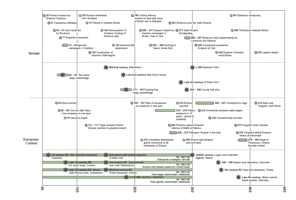
Five vessels from the Roman period have been discovered around England: the mid-2nd-century Blackfriars I ship (Marsden 1994, 33–91), the late 2nd-century New Guy’s House boat (Marsden 1994, 97–104), the c 300 Barland’s Farm boat (Nayling et al 1994; McGrail and Roberts 1999; Nayling and McGrail 2004), the late 3rd-century County Hall ship (Riley and Gomme 1912; Marsden 1994, 109– 28), and the St Peter Port ship of similar date (Rule and Monaghan 1993). Three of the vessels were found in London (Blackfriars, New Guy’s House and County Hall) in riverine contexts, as was the Barland’s Farm boat. Only the St Peter Port vessel from Guernsey was found in a maritime context. Four were believed by the excavators to be seagoing: Blackfriars, County Hall, Barland’s Farm and St Peter Port.
Blackfriars, Barland’s Farm, New Guy’s House, and St Peter Port represent a robust carvel-style indigenous vessel-building technology, the so-called ‘Romano-Celtic’ tradition. This tradition existed alongside the indigenous logboat and/or hide boat traditions, both of which pre-date the arrival of the Romans (Caesar, de Bello Gallico, iii, 13; de Bello Civile, i, 54), but continued in use throughout the period. The Hardham II logboat, for example, dates from the later Roman period (McGrail 1995). These two very different techniques would clearly have utilised disparate methods and, probably, construction sites (Milne 2008). In addition, the County Hall ship provides evidence for the introduction into northern Europe of Mediterranean shipbuilding techniques, although it was built from trees grown in south-east England (Marsden 1994, 124). While the function of this particular vessel remains unclear (ibid, 125–7), the Mediterranean method is likely to have been adopted in northern Europe as a result of the need to build warships locally. There is little hard evidence for the types of vessel operated by the classis Britannica, although a relief from Boulogne (CIL XII 3564) refers to a trireme (the ‘radians’), and ship types and crew sizes have been estimated from buildings at Dover (Philp 1981; contra Millett 2007, 177).
Besides hide boats and Romano-Celtic ships, Caesar (de Bello Gallico, iii, 9, 14; iv, 22, 25) also describes the use of Mediterranean-style warships in British waters in the 1st century BC, some built on the Loire and others possibly brought from the Mediterranean. However, the earliest vessel of any tradition discovered from Roman Britain dates from the mid-2nd century AD, representing a lacuna of two centuries for which we have no archaeological evidence. Furthermore, owing to the nature of the construction material, apart from the Broighter gold model from Ireland which is naturally a problematic source for technological details (Farrell et al 1975), there is virtually no archaeological evidence for hide boats. However, there is documentary and iconographic evidence, some of which dates from later periods, thus indicating a continuing tradition.
The temporal distribution of these largely serendipitous discoveries is erratic. There are periods of extensive maritime activity around Britain for which there is a considerable hiatus in evidence for these most complex and sizeable of maritime artefacts (Arnold 1978, 32). This lacuna in maritime evidence spans several hundred years, from the prehistoric Humber boats to the mid-2nd century AD Blackfriars I ship (Walsh 1998, 25; Adams 2001, 307). Consequently, we know more about the minutiae of the so-called ‘Romano-Celtic’ or ‘Gallo- Roman’ boatbuilding traditions (see Ellmers 1969; Marsden 1967; 1977; Arnold 1978; de Weerd 1978; 1988) than we do about the transition in maritime transport from the Bronze Age through the Iron Age to the Roman era (Walsh 1998, 25; Adams 2001, 307; see also Johnson 1999, 21).
The evidence for Britain from literary sources and maritime-related pictorial representations is minimal (Ellmers 1978). A coin of Cunobelin, the king of the Trinovantes, found at Canterbury, depicts a ship (Muckleroy et al 1978), whilst the Arras medallion (Askew 1980, 54), an intaglio recovered from the Thames (Henig and Ross 1998), a silver denarius of Carausius in the British Museum, and a billon quinarius of Allectus all depict Roman warships (http://www.kenelks.co.uk/coins/carausius/ carausius.htm). In addition, a floor tile in the British Museum, probably from London, bears a graffito depicting a lighthouse.
Apart from Caesar who, in addition to his accounts of ship types, describes his invasion passages in great detail, documentary sources are tantalisingly brief and short on detail. Pliny the Elder (Nat Hist , iv, 104) refers to hide boats framed with withies in connection with the trade in tin. Tacitus (Agr , 10, 28) records the mutiny in AD 83 of a cohort of Usipi, who sailed three liburnian galleys round the north of Scotland, and briefly notes the circumnavigation of Britain by a Roman fleet the following year. Vegetius (de re Mil , iv, 37) offers an obscure reference to 40- oared scaphae exploratoriae (scouting skiffs), which the Britons call picati. The maritime context of the AD 43 invasion is barely mentioned by Dio Cassius (Roman History, lx, 19–22). The sources for the recovery of Britain by Constantius Chlorus after the
Carausian secession are similarly uninformative (Aurelius Victor de Caesaribus, 39; Eutropius Breviarium, ix, 21–2; XII Panegyrici Latini, x(ii), 11–12 and viii(v), 6–7, 12–20). Both literary and iconographic sources remain problematic as evidence for ship and boat technology and the skills and work practices involved in seafaring.
In terms of rigging and navigation details, although the forward-located mast step found in Romano-Celtic ships indicates that they were rigged for sail, there is no direct evidence for sail apart from a 2nd-/3rd-century AD monument from Trier, a 3rd-century floor mosaic from Rheinland-Pflaz, and Caesar’s account of Venetic craft (see Marsden 1994, 70–4, 193–9; McGrail and Roberts 1999, 138–9, 141–2; Grainge 2002, 32–5, 43–4, 113–20, 125–6).
Although it is generally assumed that the majority of vessels were rigged with square sails, there are also iconographic depictions of sprit sails from this time. The navigation of the period was essentially non-instrumental (McGrail 1983; 1987, 276–84), aided by man-made navigation markers. As a result, key research themes include consideration of maritime urban topography (Bill and Clausen 1999), maritime buildings (Cohen 2008), lighthouses, and other seamarks (Naish 1985). A revealing study of discarded ballast reused as building material was recently conducted in King’s Lynn, Norfolk (Hoare et al 2002); similar exercises might well be undertaken for the Roman period in other regions.
The lack of archaeological evidence of vessels is a key issue for this period. Discoveries of Roman period wrecks and hulks will continue to be fortuitous until such time as pro-active research is undertaken (see Walsh 2006). Chances will be improved with the development of coastal morphological models that should signpost areas with the greatest potential for the deposition and preservation of wrecks and hulks.
The mechanics and mechanisms of cross-Channel trade and exchange operated long before the arrival of Roman forces on the northern coast of Gaul; considerable contact pre-empted the formal invasion as evidenced by typically Roman material culture in late PRIA contexts (see Williams and Peacock 1983). In this context, the term ‘trade’ is used as a surrogate encompassing all mechanisms of distribution utilised by pre-industrial societies. These mechanisms included distribution by means of taxation, through the imposition of rents levied in labour or in kind, administered by the state through officials or priests receiving and redistributing ‘gifts’, through reciprocity, or through the movement of cult objects (Hopkins 1983a, x; Tomber 1993, 143). In the Roman period the huge state demand to supply frontier armies involved systems of exchange rooted within social and political systems rather than commercial trade and was fulfilled by the administrative system, via taxation in kind, rather than depending on traders or purchase through the open market that could not guarantee the necessary volumes (Millett 1990, 6; cf Hopkins 1983a, xi–xii; 1983b, 84).
The extent and nature of trade is difficult to evaluate: much that was traded does not survive in the archaeological record. Current orthodoxy suggests that the cellular self-sufficiency of the ancient economy (see Finley 1973), and the general availability and bulk of grain resulted in little need for inter-regional trade, so the scale was small, comprising low-volume, high-value goods, and the status of traders was very low (see Middleton 1983, 81; cf Hopkins 1983b, 84). Moreover, Strabo (Geog II.5, 8) stated that there was no need to garrison Britain as its inhabitants readily submitted to heavy duties on both imports and exports so the costs would outweigh the gains, although Tacitus (Agri , 12) argued that mineral wealth made Britain worth conquering; Diodorus Siculus (V.22–3 and 38; cf Caesar, Gallic Wars V.12), for example, refers to trade in tin ingots from an island off the coast of Britain called Ictis. Writing at the time of Augustus, Strabo’s (Geog IV 5.2) oft-quoted list of Britain’s exports includes grain, cattle, gold, silver, iron hides, slaves, and hunting dogs, while the imports include ivory chains, necklaces, amber, glassware, and other trinkets from Gaul (ibid , II, 5, 8; IV, 5, 3).
Post-conquest, coastal and cross-Channel traffic undoubtedly became more formalised, initially controlled by the classis Britannica (see 5.4.1 below), which probably also facilitated the operation of the cursus publicus (the Imperial post or governmental communication service), although less formal trading links probably continued to operate. The bulk of cross-Channel trade appears to have shifted generally from west to east along the Channel during the Roman period from Mount Batten, Christchurch, and the entrepôt of Hengistbury (Cunliffe 1984, 4– 5; 1988, 104), with the emergence of London as the principal port of the new Roman province from the mid-1st century (Cunliffe 1984, 8). London became one of the more important centres from the late 1st to the mid-3rd century (Milne 1990, 84), although its importance should not be over-emphasised (Milne 1985, 187; cf Morris 1982, 162).
The role of the classis Britannica (Mason 2003) is of particular importance in the 1st and 2nd centuries AD. It is first mentioned by Tacitus (Annals 4.79) as the ‘Britannica classe’, while seven fleet prefects are known from inscriptions dated c AD 136–208 (Spaul 2002, 47). One of these records that the prefect was also procurator of the province of Britannia, a combination of offices which implies that the classis Britannica operated as a branch of the procurator’s office, effectively functioning as the state haulage company (Milne 2007).
Three building inscriptions from Hadrian’s Wall identify units involved in wall building suggesting that, as with other naval units, the classis Britannica was organised along similar lines to any other unit of milites undertaking routine military functions, as well as operating ships and associated infrastructure such as docks and shipyards. Rather than a navy in the modern sense, the classis Britannica was an army service corps rarely, if ever, involved in combative activity. Its role was to support the provincial government and its campaigning armies or raiding parties (see Dio Cassius LXVI 20 1–3; Haywood 1991, 13). The Vindolanda letters suggest that military and commercial activities were not mutually exclusive, and military shipping is known to have operated out of civilian ports such as Ravenna. There is also a series of undated classis Britannica tile stamps, principally from Boulogne and Desvres in France, and from Dover, London, Beauport Park, and associated sites in the Weald of Kent and Sussex. The organisation clearly had a cross-Channel communications function, with Boulogne being the principal port (Millett 2007, 176–7). The presence of fleet tiles at Beauport Park suggests an involvement in iron working and perhaps other activities. The paucity of evidence for the classis Britannica, even in what is assumed to be its heyday in the 2nd century AD, needs to be addressed.
One of the striking features of the province of Britain is the gradual decline of imports in the archaeological record, particularly fine and table wares, relative to home-produced goods, from a peak in the pre-Flavian period. This may reflect the growing economic independence of the province (Fulford 1978, 62; Mattingly 2006, 594) rather than a progressive decline in long-distance trade (Hopkins 1980). There is also a reduction in the quantities of olive oil amphorae around the middle of the 2nd century (Cool 2006, 124), which probably reflects a decline in the use of olive oil in the later Roman period (Tyers 1996, 72). This decline suggests that by the 3rd century the material culture of Britain had equalised with that of the Empire so Britain was no longer dependent on imports (Fulford 1984, 137; Millett 1990, 162).
The decline of amphorae in the archaeological record might also be explained by a change in the nature of trade away from Mediterranean amphorae- based products to a more northern European-focused trade, with the widespread use of other receptacles (Millett 1990, 158), including barrels (as evidenced by the famous Neumagen frieze), pots, glass bottles, baskets, boxes, chests, sacks or carriage loose in the hold (Parker 1992, 89). For example, Strabo (Geog V 1.8) recounts how the Illyrians came to Aquileia to collect their wine that had arrived by sea, which they then transferred into barrels to transport home (see Caesar, de Bello Gallico, VIII 42.1); similar practices may account for the abundance of amphorae found at Toulouse (Tchernia 1983, 94).
Barrel remains do occur in favourable conditions but are normally found in secondary usage, for example, as brine tanks at Droitwich (Woodiwiss 1992, 192–3), which provides little information about their original function. Wine barrels were often reused as well linings and a number of complete barrels of the 1st and 2nd centuries have been found in London. Remains of barrels have also been recovered from Newstead, Colchester, Bar Hill, Caernarfon, and Carlisle (Jones 2009). The favourable conditions found on wreck sites make them ideal for the preservation of other types of container. Glass bottles have been found on very few wreck sites but a barrel containing scrap glass was found on the Grado wreck. Chests or boxes for carrying small precious items are found relatively frequently but baskets or sacks are rarely preserved. Household pottery, lamps, and glassware are rarely found as cargo on shipwrecks despite their ubiquity on occupation sites (Parker 1992, 94).
Despite the decline in olive oil amphorae, the importation of other amphorae-based foodstuffs and the export of perishable produce continued so trade routes remained active. For example, in AD 297–98 Eumenius wrote, ‘Without doubt Britain … was a land that the state could ill afford to lose, so plentiful are its harvests, so numerous are the pasturelands in which it rejoices, so many are the metals of which seams run through it, so much wealth comes from its taxes …’ (Panegyric to Constantius 11.1; Millett 1990, 131). Still later in AD 359 Ammianus (18.2.3) refers to granaries built to store grain regularly brought from Britain for the emperor Julian’s campaigns along the lower Rhine (Frere 1986, 339; Black 1995, 86). Imports of grain to Britain are not unknown; charred grain recovered from Rochester and South Shields has been tentatively identified as bread wheat, Triticum aestivum sp., which is rare in Roman contexts. Occasional importation from much further overseas, possibly to compensate for an exceptionally bad British harvest (Salway 1981, 618–20), is indicated by a large quantity of charred grain found inside a London shop; seeds of plants mixed with the grain indicate that the crop had been grown in the eastern Mediterranean (Straker 1987, 151–5).
The continued late 3rd-century use of the North Sea route linking London to the Rhine is demonstrated in the archaeological record by the import of continental pottery produced at Mayen in the Rhine valley and in the Argonne valley between the Meuse and the Aisne. Similarly, the use of the Atlantic route is demonstrated by the presence in Britain of ceramic à l’éponge, produced in the area between the Loire and the Garonne. The main distribution of this pottery is near to Southampton (Clausentum) but finds in the Severn Estuary and as far north as Gloucester indicate direct shipment from the Gironde via the western seaways and the Bristol Channel (Cunliffe 2001, 443–5, figs 14 and 15).
Maritime evidence
There is little direct maritime evidence for traded goods in northern Europe and the evidence is dominated by building materials. Stone from Blackfriars I came from the Medway and was probably destined for building London’s walls; the St Peter Port ship carried a cargo of pitch (Rule and Monaghan 1993); and the Ploumanac’h wreck discovered off the Brest peninsula comprised lead ingots from south-west England (L’Hour 1987). Besides these, there are other notable deposits: contemporaneous amphorae recovered from the Little Russel Channel, Guernsey, 3rd-century coins from the Needles, Isle of Wight, and deposits from Richborough, Kent (Lyne 1999), from Nournour on the Isles of Scilly (Fulford 1989), from Herd Sand at South Shields (Bidwell 2001), from Hartlepool Bay (Swain 1986), and from West Caister marshes (Fryer 1973, 269) have been interpreted as remains of either Roman vessels or cargoes (see Walsh 2002).
The famous Pudding Pan site off the north Kent coast is now thought to comprise at least two wrecks (Fig 5.3). The main assemblage dating from AD c 175–195 comprises central Gaulish samian (Fig 5.4), a range of amphorae, and a solitary African red slip bowl, while the later 1st-century assemblage (AD c 65–85) comprises a number of mortaria and amphorae recovered between the Oaze Deep and Pan Sand. There is also a small assemblage of unprovenanced early 3rd-century material from the same locality (Walsh 2006; see also Hartley 1977, 6).

In addition, various Roman artefacts have, for centuries, been and continue to be, recovered from maritime contexts in northern European coastal waters including amphorae (Galliou 1982; Sealey and Tyers 1989; Harmand 1966; McDonald 1977, 24, fig 8), pottery (Monaghan 1989; 1991; Pownall 1778), coins (Dean 1984, 79), ingots (Craddock and Hook 1987; L’Hour 1987), anchors (Boon 1977a; 1977b; Cook 1971; Dean 1984, 79; Marsden 1990, 71; Markey 1991; 1997), military equipment (Bidwell 2001), roof tiles (Spurrell 1885, 281–4), and brickwork (Pownall 1778, 282). However, although individual finds have been researched and occasionally published, there has been no synthesis similar to the corpus of artefacts found off the French coast (see Galliou 1982).
At least some of these finds are likely to represent casual losses, either thrown or lost overboard, rather than a shipwreck or cohesive archaeological site, but concentrations of material discovered in similar locations over time must warrant closer inspection. Similarly, significant offshore navigational hazards, like the infamous ‘ship-swallower’, the Goodwin Sands, upon which ships throughout history have met their fate, also demand investigation. The incidence of ship losses in the final approach to ports is not uncommon so wrecks from various periods frequently occupy virtually the same spot; the approaches to the Thames (see Walsh 2006), to Portchester and Clausentum, to Lulworth Cove and its attendant hillfort on Bindon Hill, and the riverine approaches to Fingringhoe and Camulodunum are all good examples.
It is surelysignificant that, with the exception of investigations at Pudding Pan (Walsh 2006) and at Yarmouth Roads (Tomalin 1997), little or no prospection has actively sought the presence of Romano-British craft. Moreover, controlled archaeological trawls in the offshore zone have been used effectively in the Magnus Portus area (Tomalin 2006) and at Pudding Pan (Walsh 2006).
Merchandise from many parts of the Empire seems to have reached Britain via a complex system of transhipment centres, using river barges and seagoing vessels, up the Rhône and the Rhine, then across the Channel to the Thames. Strabo (Geogr., iv, 5, 2) lists the four main Channel crossings as originating from the mouths of the Rivers Rhine, Seine, Loire, and Garonne. The overwhelming concentration of inscriptions related to the shipment of goods on the Rhône-Saône axis highlights the dominance of this route as the principal commercial axis of Gaul (Middleton 1979, 82, fig 1).
The complete absence in northern Europe of ships built in the Mediterranean and the preponderance of native craft probably reflects the largely terrestrial and riverine contexts in which the majority of these vessels have been discovered. Although the presence of Mediterranean ships cannot be discounted, the predominance of local ships and boats seems a good indication of the types of vessel that frequented the major ports of northern Europe. This appears to confirm that long-distance trade between the Mediterranean region and northern Europe was conducted primarily via the inland waterways of Gaul (Strabo, Geogr IV 1.2, 1.14), which were navigable along all the main axes of communica- tion (Middleton 1979: 82), rather than open-sea voyaging around the Atlantic coast. The straits of Gibraltar presented a considerable obstacle to sailing ships trying to pass from the Mediterranean into the Atlantic. Thus Mediterranean cargoes are more likely to have used the Garonne route, loading at the port of Narbo Martius then, via the Rivers Aude, Garonne (Garumna) and Gironde, reaching the port of Bordeaux (Burdigala) on the Atlantic coast (Jones 2009).
The pottery assemblage from the St Peter Port wreck appears to support long-distance voyaging as it covered a wide geographical area from northern France to North Africa (Rule and Monaghan 1993). However, the excavators believe the Algerian amphorae were loaded in Atlantic Spain rather than in Africa, although they could equally have been conveyed via the waterways of Gaul. The ship, therefore, appears to have been engaged in cabotage or coastal tramping, calling at ports along the route, buying and selling wares on an ad hoc basis. This practice, as with transhipment and quayside dealing, seems to have been extremely commonplace, with frequent references to ‘long distance traders on trampships’ and merchants who hawked their retail goods from port to port (Tomber 1993, 147; Parker 1984, 103). The absence of any known wrecks in northern European waters that originated from the Mediterranean supports this notion. This system of transhipment appears to have continued on the British side of the network, with the road system connecting with navigable rivers at places like Lincoln, York, Catterick, and at Hadrian’s Wall.
Although pottery seems rarely to have been traded in its own right, it has been used as a proxy for trade, owing to the paucity of direct evidence for the volume of trade and its organisation. The most favoured method to date has been to establish a regular and structured relationship, such as that between pottery and the grain supply for the army, the so-called ‘piggy-back’ or parasitic trade (see Tomber 1993, 143). This suggests that merchants contracted to supply the army filled any spaces with luxury items to sell privately (see Middleton 1983, 80). There is considerable evidence for this activity in the numerous laws passed to prevent misuse of the cursus publicus (the state-run courier and transportation service) (Black 1995, 78), and the annona (grain) was often mixed with non-state cargoes (see Whittaker 1983, 165). The fact that pottery from grain-growing areas appears on distant military sites provides further evidence for this activity. It is probable that finds in Britain may have been the result of a similar type of ‘piggy-back’ cargo loading; ceramique a l’eponge, for example, manufactured in the Bordeaux region, seems to have arrived in Britain on the back of the wine trade (Fulford 1978, 45). Exeter has produced the largest quantity found from any site in Britain, together with significant quantities of Spanish and North African amphorae (Holbrook and Bidwell 1991, 21, 217–18).
Military supply clearly played an important role in the maritime routes, not only cross-Channel but around the British coast. Black-burnished ware 1 (BB1) was produced predominantly in south-east Dorset and distributed via the rivers and coasts of the West, most notably appearing on Hadrian’s Wall. It has been suggested that its distribution was driven by the demand for Dorset salt (Gerrard 2008, 121; Allen and Fulford 1996, 268), or for grain and textiles from the south-west (Greene 1979, 103). In contrast, the east coast was the major route of pottery distribution for the Antonine Wall, with the pattern of pottery distribution reflecting changes in troop distribution; ships now sailed from the Thames Estuary to the Firth of Forth rather than from the Bristol Channel to the Solway Firth (Gillam 1973, 55). For example, black-burnished ware 2 (BB2) was made and distributed in the East, primarily via the Thames Estuary, with very little overlap with BB1 distribution other than in the northern frontier region (Allen and Fulford 1996, 223–81). The paucity of BB2 on sites between the south- east and the northern frontier must be indicative of direct shipment from the potteries to the Antonine Wall (Gillam 1973, 57).
Pottery distributions appear to support the price advantage of water transport adduced from Diocletian’s Price Edict, with pottery initially transported away from its destination along water courses. For example, south Gaulish wares seem to have been shipped down the Tarn and Garonne and transferred to seagoing vessels at Bordeaux. Similarly, central Gaulish wares seem to have been shipped down the Allier to Nantes, where they were transferred to seagoing ships. It is not known how these wares were distributed in Britain but it is assumed that they landed at a south-eastern port, either London or Richborough, and were then distributed via coasters rather than overland. East Gaulish wares were transported quite differently, with direct shipping from the Rhineland to the Humber (Jones 2009). In addition to the altars from Domburg (Section 5.5.3), there is physical evidence for direct trade between Britain and the Rhineland in the form of objects of Whitby jet found on the Rhineland and Rhineland glass found at York (Dickinson and Hartley 1971, 131).
The advantages of water transport are clearly displayed by the asymmetric distribution of British pottery. The products of the Alice Holt/Farnham industry located on the River Wey were distributed via the waterways throughout much of the south- east and captured the bulk of the London market (Millett 1990, 170, fig 71; Duncan-Jones 1974, 368). Similarly, the wider distribution of Oxford wares over New Forest wares, which are contemporary and similar in quality and utility, appears to reflect the availability of water transport via the Thames, thus enabling access to the large cities of Cirencester and London (Fulford and Hodder 1975, 26–33).
Problems with evidence
How useful is pottery as an indicator of trade? Tableware is used as an indicator of more substantial trade because even the finest pottery was of such low value that it is thought unlikely to have been carried as a sole cargo (see Fulford 1984, 132–5; Millett 1990, 157; cf Fulford 1978). However, recent research challenges this notion and suggests that the absence of pottery cargoes may be a problem of detection; although a significant portion of trade was undoubtedly conducted ‘piggy-back’ or parasitic on more substantial trade, the model seems too simplistic (Walsh 2006). Pottery reflects rather than generates trade (Tomber 1993, 143); pottery such as tableware or fine wares were not directly involved in trade and containers such as amphorae, that were used to transport wine, olive oil and olives, fish sauces and salted fish, fruits and dried fruits, nuts, pepper, beans, honey, grain, and flour, were not themselves objects of trade, and, as stated, may have been substituted for other containers as the focus of trade moved north (see Pucci 1983, 109).
The ubiquity of pottery sherds in the archaeological record gives them undue prominence as a trading commodity and the difficulty of distinguishing between imports to supply the army and genuine market trading compounds the matter (Evans 1981, 519). Strabo’s aforementioned statement regarding Britain’s imports excludes pottery (Geogr 4.5.3), which contradicts archaeological findings and suggests that pottery was not worthy of mention (Evans 1981, 520). This is undoubtedly because most pottery was used to convey more valuable contents and therefore had no more value than a packing case (Evans 1981, 525).
Recent analysis has reconsidered the function of the ‘Saxon shore’ forts in the contexts of the political division of Britain into a militarised zone in the North and a civilian zone in the South, the economic climate of the 3rd century and the reorganisation of the army in the late Roman period (Casey 1994, 24–5; Pearson 2005, 76–7, 84; Hopkins 1980). Recent excavations within some of the forts support the notion that they functioned as supply bases. At Reculver, varied levels of occupation suggest possible temporal changes in function (Philp 2005, 228–9), whilst others (Burgh, Brancaster, Portchester, and Caister- on-Sea) have revealed evidence for animal carcass processing, leather working, and industrial activity (Grant 1975, 378–408; Hinchliffe and Sparey Green 1985, 174; Cotterill 1993, 237; Darling and Gurney 1993; Pearson 2005, 83; Moore and Heathcote 2004, 13). Within some forts (eg Portchester) the presence of open gravelled spaces and the use of ephemeral wooden internal structures suggests they may have been used to pen animals or to store grain, possibly the annona (Philp 2005; Cotterill 1993, 238; Cunliffe 1975). Similarly, pottery provides further evidence that the forts operated as bases involved in the transportation of goods. The evidence shows a distribution of certain pottery types, including types produced in Gaul, along the northern frontier and along the south and east coast of Britain (Allen and Fulford 1996, 267; 1999, 177).
Thus the function of the shore forts is now seen primarily as logistic rather than defensive, with the forts operating as fortified ports (Milne 2008). As such, future research involving the forts needs to consider further the role of the military in facilitating mechanisms of economic exchange (Pearson 2005, 83). This requires a detailed synthesis of how they functioned as a whole, including the forts of Wales and Gaul, in the commercial and economic context of the northern provinces (ibid, 74, 85). It has been suggested that some of the forts were located within or adjacent to areas with low villa density, usually interpreted as imperial estates (Allen and Fulford 1999, 179). Within this context, more detailed research of the fort hinterlands may help identify road systems linking forts with the interior and the presence of any vici (small settlements), in order to improve our understanding of the relationship between forts and their hinterlands, particularly for those forts that have suffered extensive damage due to erosion (Good and Plouviez 2007, 10).
The landscape of Roman Britain was not a passive backdrop; it was moulded by human action and, at the same time, influenced further action and interaction. The ongoing and reflexive relationship between people and surroundings provides traces within the archaeological record which, in turn, give opportunities for contextual interpretation of identities and the use of space.
To date, much of the study of Roman Britain has focused on the process of Romanisation (Revell 2009) and functional factors such as the use of resources and developing environmental and economic aspects (Petts 1998). Roman archaeology has, perhaps, been slower to adopt more interpretative approaches that consider agency and meaning.
This is not to overlook more traditional approaches to ‘space’, such as the control of territories and associated landing places and coastal resources, which would have a bearing on identity, but to advocate a broader interpretation of evidence drawing on recent work and approaches.
There is a need to look at the Roman seascape and coastscape as an active space as it was experienced. These areas or environments did not have a single ‘meaning’ as this is highly individualistic. However, it is possible to explore the potentially multi-level and reflexive nature of space linked to the marine and maritime zone through the evidence base from the Roman period (see Ingold 1993).
When seeking to understand identity in the Roman period there are challenges related to the differential social, political, economic, and cultural ‘space’ of the province which were based on unequal power relationships which affected all aspects of life (Revell 2009). In terms of maritime and coastal environments this raises a wide variety of research questions related to the significance and/or ‘difference’ of these environments and how this may have affected the varying experiences of those living within, or passing through, them and the negotiation of social identities. Were fishermen and sailors in Roman Britain engaged solely in the exploitation of marine resources and, therefore, were they part of a maritime community or was there a mixture of agricultural and marine cultivation and exploitation? For example, 19th-century oystermen in Galway Bay never used sails because they were primarily farmers and only part-time fishermen so could not justify the cost of sails (Wilkins 2001, 57). What effect did the (maritime) Roman invasion have on social identity, both for the indigenous population and for the invader? How did this alter the individual’s perception of the sea/coastscape in which he lived?
The Solent, discussed in detail below, was an integrated land/seascape during this period and this would have shaped both communal and individual perceptions of maritime space.
Besides coastal communities, those travelling on board vessels experience maritime space, living within a mariner-based community. Some journeys may have involved a short voyage, such as across the Solent, while others would have involved considerable distances. The experience of the mariner or passenger in terms of the agency of space is an area of research that it not particularly advanced (see Farr 2006). More work has been done on the required skills and practicality of sailing earlier vessels (McGrail 1987), and on the experience of maritime space in the broader sense of requirements for understanding the sea, weather, and landing places.
Discussion of the extent to which the division of space, roles, and materials on board vessels affects social actions and identity is not well developed. This is not surprising owing to a greater focus on nautical technology and a lack of vessel remains from Britain. However, there are opportunities to review the division of space, goods, and activities that shaped identities based on reconstructed examples such as the Blackfriars (Marsden 1994) and St Peter Port (Rule and Monaghan 1993) vessel remains.
Social space on vessels was dictated by the functional space related to cargo and vessel performance. The relations between crew members, many of whom may have come from different parts of the Empire, may be reflected within material culture and non-functional activities. The importance of religious beliefs to those on board ships that traversed the often dangerous and unpredictable seas is demonstrated by the presence of shrines, often sited on the ship’s quarter deck, an area which continues to have special ceremonial significance (Reilly 1975).
The association between water and the sacred has a long tradition in Britain and north-western Europe (Fitzpatrick 1984; Merrifield 1962; 1987; Bradley 1998; Webster 1997; Parker Pearson 2003, 179–89; Osborne 2004; Hingley 2006; Kiernan 2009), particularly the practice of depositing votive offerings such as weaponry, coins, animal and human bone in inland water sources such as wells, rivers, lakes, and marshes. Throughout the Roman period this practice continued, albeit with some changes in the types of objects deposited, such as the inclusion of imported samian pottery (Fulford 2001; Bird 1992, 86–7; Willis 1998; 2005), reflecting the availability of new forms of material culture.
Ritual deposition in the seas surrounding Britain is less well known; such evidence as there is derives primarily from military contexts. Altars dedicated to the sea god Neptune have been found in the fort at Lympne (RIB 66), on the Antonine Wall at Castlecary (RIB 2149), and along Hadrian’s Wall at Birdoswald (RIB 1929d; Frere 1986, 329), Carvoran (RIB 1788), and at Newcastle-upon-Tyne (RIB 1.1319). The latter, decorated with a dolphin, was accompanied by a further altar to Oceanus, adorned with an anchor (RIB 1.1320). Similarly, a portable lead shrine excavated at Wallsend fort (Segedunum), depicting Mercury/Hermes (the god of travellers) accompanied by a dolphin and a bridled sea-horse, has been interpreted as protection for those travelling across water (Allason-Jones 1984, 231). The presence of such altars may be interpreted as representing the completion of vows following successful military sea crossings from the Continent (Hassall 1978, 41).
Direct evidence for votive deposits by civilian traders is less secure despite the importance of maritime trade (Fulford et al 1997, 124). An altar stone to Neptune and Minerva from Fishbourne (RIB 92) may be associated with an inscription to the two deities of the same date dedicating a temple at nearby Chichester (RIB 92), although the late 1st-century AD date may relate to Chichester’s early role as a military supply port. Altars built into the Roman riverside wall attest to London’s important role (Goodburn et al 1976, 378), whilst the discovery of a copper as of Domitian (AD 88–89) in the mast step of the Blackfriars ship attests to the superstitious nature of sailors (Carlson 2007; Merrifield 1987, 54–7). More formal evidence for religious deposition comes from two harbours at Colijnsplaat and Domburg (Hondius-Crone 1955; Stuart and Bogaers 1971; Bogaers 1967; 1971; Bogaers and Gysseling 1972). Although now lying off-shore (Birley 1957), these harbours were originally situated along the estuary of the Scheldt, serving ships trading between the coastal regions of Gaul and the east coast ports of Britain on one hand, and the Rhineland and Gallia Belgica on the other (Hassall 1978, 42–3; Middleton 1979, 95; Milne 1990). Over 150 altars (Birley 1957, 173; Bogaers and Gysseling 1972; Halsall 1978, 43), dedicated in gratitude after the successful completion of trading voyages, highlight the extensive range of goods being traded between the northern provinces, including allec (fish sauce), pottery, figurines, salt, and wine (Bogaers 1971; Halsall 1978, 44–5).
The off-shore location of these shrines, combined with changes to the coastline, might explain why few securely attested coastal shrines and temples are known from Roman Britain (Fulford et al 1997, 122–7). Although some coastal religious structures do survive, like the 4th-century temple at Brean Down (ApSimon 1965, 199), they are little understood. Future research needs to focus on better understanding these surviving structures in relation to the sea. Identification of the Roman coastline would help to identify the probable location of shrines and temples. In light of known patterns of structured votive deposition relating to inland water sites, a re-examination of coastal material cultural finds may also help to identify Roman period religious and ritual behaviour in relation to the sea.
Roman seascapes and identity
Shipboard space and identity
Religion