Kieran Westley and Geoff Bailey with William Davies, Antony Firth, Nic Flemming, Vince Gaffney, and Phil Gibbard
The start of the Palaeolithic in Britain is defined by its earliest known human occupation, currently dated to 900–800 kiloannum (ka) by the site of Happisburgh (Parfitt et al 2010), and its end by the onset of the Holocene approximately 11.5ka ago. The period is generally subdivided into Lower, Middle and Upper phases on the basis of typological differences in artefact assemblages. The Lower Palaeolithic, from 800 to 300–250ka, initially witnessed the arrival of a currently unknown hominin species, probably a form of Homo ergaster/erectus, which made use of a simple core-and-flake lithic toolkit. From 500ka onwards, the western European species Homo heidelbergensis appears in the Lower Palaeolithic record and is associated with distinctive Acheulean handaxes, though core-and-flake technology (often referred to as ‘Clactonian’) is still evident from a number of sites. Over the Middle Palaeolithic (300–250 to 40–35ka) H heidelbergensis gradually evolved into Neanderthals who themselves developed a toolkit characterised by the use of prepared cores, generally referred to as Levallois or Mousterian technology. From 35ka onwards, the Upper Palaeolithic, anatomically modern humans colonised Britain, ultimately replacing its Neanderthal populations and bringing with them a different technology, typified by the use of lithic blades and bone implements.
Throughout this timespan, massive cyclical changes in climate transformed the landscape. These consisted of transitions between mild inter- glacials similar to, or warmer than, the present, and cold glacials characterised by continental ice sheets, Arctic or periglacial conditions and sea- level lowering that created a continuous landscape encompassing the British Isles, and north-west continental Europe. The general climatic tendency was for colder conditions and sea-level lowstands to be interposed with shorter peaks of warmth and ice melting. Consequently, Britain was a peninsula of continental Europe for most of the Palaeolithic, with isolation only during brief interglacial highstands. These dramatic changes also influenced the human colonisation of Britain such that its occupation was spatially and temporally discontinuous, marked by repeated episodes of inward migration and colonisation from continental Europe interspersed with depopulation and localised extinction events.
The above palaeoenvironmental changes serve two other purposes. Firstly, from the general standpoint of Quaternary research and Palaeolithic archaeology, they provide a chronological framework based on lithostratigraphic and biostratigraphic evidence of palaeoenvironmental change correlated using relative and absolute dating methods, and evidence of global climate change from the deep-sea oxygen isotope record (Fig 1.1). The period is therefore divided into named lithostratigraphic stages that are correlated with cold or warm Marine Isotope Stages (MIS) (eg the Ipswichian interglacial dating to c 135–115ka correlates with MIS 5e) (Lowe and Walker 1997).
Secondly, from a maritime archaeological perspective, sea-level change meant that the position of the coast varied throughout the Palaeolithic. Current coastal sites may thus reflect purely terrestrial activities during sea-level lowstands while current inland sites may preserve coastal evidence left behind during highstands. The tendency of sea levels to be lower than present through most of the period means that the latter situation is rare, and hence most Palaeolithic coastlines are now submerged. The relatively shallow (<200m) bathymetry around Britain also meant that vast tracts of land were exposed during lowstands. Evidence of purely terrestrial activities and landscapes can therefore be found in modern maritime contexts, and must be investigated and interpreted using maritime methodologies. The upshot is that this chapter must take into account all submerged Palaeolithic evidence, regardless of whether it constitutes evidence of past maritime activity.

Previous research on Palaeolithic maritime issues is sparse, not only in Britain but globally. This results from the lack of evidence created by submergence of the relevant archaeological record, and, for the last half-century, the belief that coastal and maritime adaptation was a relatively recent human development (Erlandson 2001; Bailey and Milner 2002). Within the last decade this situation has been redressed by an increasing number of sites pushing back the earliest date of coastal use, most recently the 160ka finds at Pinnacle Point in South Africa (Marean et al 2007) and a growing interest in the role of coastal environments in prehistoric migrations (Stringer 2000; Flemming et al 2003; Bailey et al 2008). This has been accompanied by increased attempts to investigate submerged prehistoric landscapes systematically, driven by a number of factors, not least accumulating evidence that sites and landscapes can be preserved on the continental shelf, increasing quantities of sea-level data and improved precision of palaeogeographic reconstructions, improvements in marine remote sensing technology and, finally, an increasing threat to the submerged record brought about by commercial use of the seabed (Bailey and Flemming 2008).
The growing interest is also reflected in the most recent research framework document for the British Palaeolithic (Pettit et al 2008) which identifies several maritime questions within its overall research themes, and the production of a research and management framework covering the submerged prehistoric archaeological resource of the North Sea (Peeters et al 2009). This chapter will therefore complement these previous frameworks by providing more detail on maritime-specific issues than Pettit et al’s (2008) primarily terrestrially-oriented exercise and considering areas that did not fall within Peeters et al’s (2009) remit, such as the Irish Sea. Notwithstanding this increased interest, numerous questions remain regarding the origin and development of maritime strategies for migration and subsistence, and the role of coastal and now-submerged areas in the Palaeolithic colonisation and occupation of Britain. Many British Palaeolithic sites are located on, or near, the present coast (Fig 1.2). These include the sites of Pakefield, Happisburgh, Swanscombe, Clacton-on-Sea, Boxgrove, La Cotte de Saint Brelade, Kent’s Cavern, Coygan Cave, Hoyle’s Mouth, Sudbrook, Goat’s Hole/Paviland, and Hengistbury Head. However, the majority were occupied when sea levels were known to have been considerably lower; thus, while currently coastal, they do not reflect coastal or maritime adaptations as demonstrated by their lack of evidence indicating maritime activities (eg seafaring, marine resource exploitation). There are some exceptions to this rule including Boxgrove (artefacts deposited in an intertidal environment (Roberts and Parfitt 1999)), Happisburgh and Clacton (artefacts deposited in estuarine environments (Bridgland et al 1999; Parfitt et al 2010)), and Priory Bay (artefacts deposited in gravels of either marine or fluvial origin (Wenban-Smith et al 2009)). Although this indicates that hominins were not avoiding coastal environments, none of these sites contains definitive evidence of marine resource use. The earliest-known exploitation of marine resources from elsewhere in Europe, eg in Gibraltar and Italy, dates from at least as early as 50–30ka, and is associated with Neanderthals (Stiner 1994; Stringer et al 2008). In South Africa, this date can be pushed back even further to 160ka (Marean et al 2007). The use of modified marine shells as body ornamentation is well-documented elsewhere in Europe, for Palaeolithic contexts of <100ka, as is the artistic depiction of marine fish and mammals (Cleyet-Merle and Madeleine 1995; Stiner 1999). Unfortunately, such evidence of the symbolic exploitation of marine resources is not known from Britain, not even for its terminal Palaeolithic after 14ka which has limited evidence for marine resource exploitation such as saltwater fish bones (Newell and Constandse-Westermann 1996), transported marine shells (Barton 1999), and stable isotope measurements (Richards et al 2005).
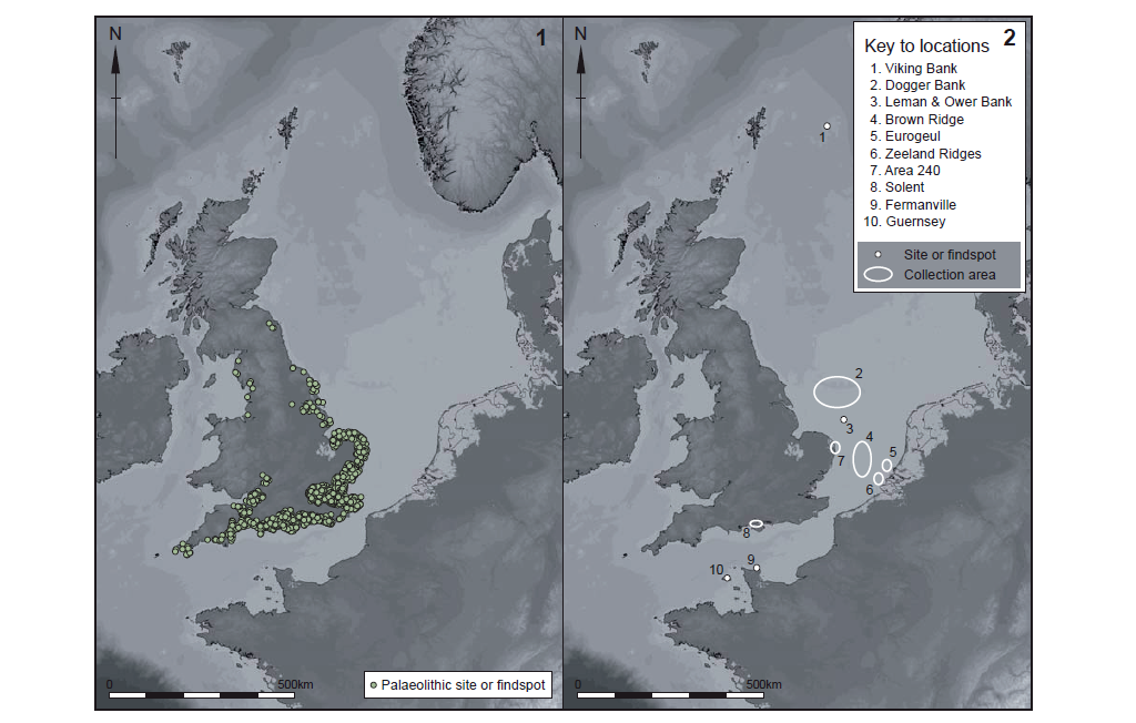
The scarcity of evidence for marine resource exploitation in the British Palaeolithic is at least partly due to the loss or obscuring of large portions of the record by two key mechanisms. Firstly, large parts of the British landmass were covered by ice sheets during glacial phases. At the height of the most recent glacial, the Last Glacial Maximum (LGM: 24–21ka), only areas south of the Midlands escaped glaciation (Bowen et al 2002). Previous glaciations were even more intense, with ice reaching as far south as the Thames (Clark et al 2004). The result is that much Palaeolithic evidence from areas that were overrun by ice has been successively scoured away. Secondly, if one bears in mind that Britain was generally occupied at lower sea-level stands, when it was a full part of the European mainland, it can be assumed that much of its Palaeolithic record is now submerged. Occasional finds by fishing or dredging vessels as well as an intact archaeological site on the French Channel coast at Fermanville (Scuvée and Verague 1988) merely hint at the wealth of material we are missing. It is also worth noting that until the last decade, with the exception of Mousterian lithics from Fermanville, no published site in north-west Europe demonstrated the survival of pre-LGM submerged material. Now however, there is no question that Palaeolithic evidence from before the LGM can survive on the shelf around Britain (eg Wessex Archaeology 2009b). As before though, most of these sites are seen as coastal/marine by dint of their submergence, rather than because they represent adaptations to marine environments. As far as can be ascertained, they were occupied at periods of low sea level, and thus probably reflect lacustrine and riparian adaptations (Hosfield 2007).
Effectively, the old problem of ‘absence of evidence’ prevails in our attempts to reconstruct possible levels of Palaeolithic maritime activity: the sites have not yet been recovered that can reveal such behaviour. Given the dynamic fluctuations in the glacial and sea-level prehistory of Britain and her neighbours, we should expect to find such evidence (should it exist) largely in now-submerged regions, especially in/near more southerly latitudes of our study region which were less affected by direct glacial action. These areas may also hold a considerable terrestrial Palaeolithic resource which could extend as far back as the earliest known occupation of the British Isles.
While we may accept that a large proportion of Britain’s Palaeolithic landscapes are now submerged, a major issue to contend with is whether or not they have been preserved. Areas inundated by the sea are susceptible to reworking by tidal currents and wave action, especially where the substrate is unconsolidated. Compared to coastal erosion and deposition, offshore reworking of the seabed reaches less deep (Davis and Fitzgerald 2004). At first glance, this implies that the pacing of sea-level rise affects the degree of reworking because it determines how long an area remains in the coastal zone before it becomes open sea. In reality, this ‘pacing’ is unlikely to be the main determinant of preservation. The speed of glacio-eustatic sea-level rise at glacial terminations has been estimated to be around 0.6–2.5m per century with potential short-lived pulses of up to 5m per century (Rohling et al 2008). At these fastest rates, the worst storm waves will impact a coastal site for 50–100 years prior to mean sea level reaching the site. Storm and fair weather waves then break directly over the site for another 100–200 years until it is submerged deep enough to be protected from all but the largest waves. These estimates are for the fastest rates of rise such as occurred during short-lived meltwater pulse events. For the rest of the time, the duration of wave attack would have been even longer, and, given that a single storm event can rework an archaeological site, this suggests that variations in the rate of sea-level rise alone cannot control the preservation of Palaeolithic sites.
Instead, the key forces controlling the degree of erosion include wave height, fetch, coastal topography and configuration (Flemming 1983). For example, waves break further offshore on low- gradient coastlines resulting in less energy reaching the shoreline. Abundant onshore sediment transport can also promote preservation by burying a site while it floods. Sheltered pockets on scales of metres to tens of kilometres can be produced by features which absorb or dissipate wave energy, for instance, headlands, spits, barriers, caves, reefs or rocky outcrops. Additional controls are provided by the substrate enclosing the archaeological material and its depth of burial. Material embedded within hard clays or compacted peat is more likely to survive in situ compared to soft muds or silts. In unconsolidated sediments, stratigraphy and archaeological material could potentially survive higher energy transgression provided it was buried to sufficient depth prior to inundation, so that waves could only rework the uppermost levels of the overburden. A further consideration specific to the submerged Palaeolithic, particularly its pre-Ipswichian/MIS 5e component, is that preserved sites and landscapes have to survive repeated inundation and exposure by successive glacial/interglacial cycles (Wenban- Smith 2002).
The diversity of coastal environments and energy conditions around Britain implies that a spectrum of preservational states is likely and ranges from in situ sites and landscapes with good organic preservation to fluvial terrace accumulations of secondary context lithics and finally to stray artefacts entirely removed from their original context (Hosfield 2007; Ward and Larcombe 2008). This is not so different from the terrestrial Palaeolithic, where evidence also includes in situ and reworked material. Indeed, the bulk of the British Lower and Middle Palaeolithic resource is typified by accumulations of artefacts in river terrace gravels that accumulated over tens of thousands of years, supplemented by a handful of primary context sites. In some instances, the coarser gravels may also contain fine-grained clay-silts or sand lenses with associated palaeoenvironmental evidence which reflect lower energy conditions and palaeolandsurface development (Wenban- Smith 2002). Each type of evidence is capable of contributing uniquely to Palaeolithic research. While the primary context evidence provides detailed ‘snapshots’ of hominin behaviour at specific times and places, the reworked evidence is better suited to addressing long-term trends in population history and technological change, particularly when the assemblages can be placed in a chronological framework, as has been devised for the gravel terraces of Britain (Ashton and Lewis 2002; Hosfield and Chambers 2004).
Evidence of underwater site and landscape preservation comes from a variety of sources. On the one hand, geological investigations (eg Cameron et al 1992) have identified and mapped shelf surface and buried deposits using seismic profiles and, where possible, tied them to the Quaternary chronostratigraphic framework using sedimentary data from cores and boreholes. Considerable quantities of data, including bathymetric, seismic, and borehole/ core records, have been collected across the UK shelf by the British Geological Survey, UK Hydrographic Office, various universities and commercial organisations. In many instances, the data have not been made available for archaeological research, though progress has been made in recent years as exemplified by the North Sea palaeolandscapes project, which produced detailed 3D palaeolandscape reconstructions of the Dogger Bank in the Late Pleistocene and Early Holocene using seismic profiles from the petroleum industry (see Gaffney et al 2007; 2009). On the other hand, artefacts and palaeolandscape fragments have been recovered from the shelf by commercial activities (eg fishing and aggregates dredging) or eroded out by natural processes. Examples of the former include the Zeeland Ridges Neanderthal skull fragment (Hublin et al 2009) and the Area 240 lithics (Wessex Archaeology 2009b), while the latter includes Lower Palaeolithic implements exposed by cliff retreat at Happisburgh (Stringer 2006) and late Upper Palaeolithic lithics eroded from submerged peat and washed ashore at Titchwell (Wymer and Robins 1994).
In short, preservation of submerged archaeological sites and palaeolandscapes dating to the Palaeolithic is possible around the British Isles. However, the degree of preservation is highly variable, with areas of high potential and known Palaeolithic/Pleistocene deposits interspersed with areas of low potential and a lack of preservation, or areas where the degree of preservation is unknown. Progress has been made in terms of identifying the types of deposit most likely to preserve useful evidence (eg Wenban-Smith 2002; Hosfield 2007) and efforts have been made to map zones of archaeological potential, most notably in the southern North Sea (Gaffney et al 2009; Ward and Larcombe 2008). In general, the current state of knowledge is such that the most straightforward zones to classify with regard to their archaeological potential are those with little or no potential – primarily zones of clean bedrock or bedrock overlaid by recent marine sediment. For areas with thicker sedimentary deposits, classification is possible if there is sufficient information regarding the origin of the sediment; for instance, to distinguish between gravels created by lowstand fluvial processes as opposed to highstand marine action. Going further than this and judging the potential of individual deposits or sequences is currently not possible except in instances where geophysical data, sediment samples, and reliable dating information are available in sufficient detail to reconstruct accurately the palaeolandscape context and post-depositional taphonomic processes for a given sedimentary unit (eg Gaffney et al 2009; Wessex Archaeology 2008a–d). Effectively, what is needed is better chronological control on submerged Pleistocene deposits combined with a better understanding of the formation and post-depositional processes affecting them. If this information becomes available, then it should be feasible to create more refined maps of archaeological potential than are presently possible.
The broadest overarching issue for the maritime Palaeolithic is the lack of data. Known archaeological sites do exist, but are few in number. Instead, the vast majority of the data covering the relevant period are palaeoenvironmental. While these are undeniably important to Palaeolithic research and therefore deserving of their own research priorities, they can only go so far in answering archaeological questions. In order to obtain more useful archaeological data, the following are necessary:
A definitive reconstruction of Palaeolithic sea-level change and palaeogeography currently does not exist for the British Isles and is reflected by the number of extant reconstructions (eg Jelgersma 1979; Lambeck 1995a; Coles 1998; Shennan et al 2000, 2006; Milne et al 2002; Peltier et al 2002). Each differs slightly, a function of variation in the underlying data or models. However, the shelf-scale pattern of change depicted is broadly similar.
Generally speaking, the expansion of an ice sheet over the British Isles during glacial periods isostatically depressed the underlying land, offsetting the glacial eustatic fall such that the most heavily glaciated areas (primarily Scotland and Northern Ireland) experienced shelf exposure similar to the present. By contrast, the unglaciated shallow shelves around England were exposed by the eustatic fall such that large tracts of the North Sea, English Channel and Celtic Sea were subaerial. Shelf exposure in the unglaciated areas was also enhanced by the creation of a glacial forebulge which raised the crust even higher above contemporary sea level (Fig 1.4; Lambeck 1995a).

Therefore, maximum shelf exposure occurred during, or immediately after, glacial maxima due to the global-eustatic fall and forebulge uplift. Such periods include MIS 12, 10, 8, 6 and 2, glacial periods characterised by the ice sheet growth and low (~–90 to –120m) global eustatic sea levels (Figs 1.4, 1.5, 1.6(2) and Rohling et al 2009). In each cold stage, the exact distribution of exposed and habitable land depended on the interaction between glacio-eustasy, isostasy, and the extensions of ice onto the shelf. The largest exposures of habitable shelf probably occurred prior to glacial maxima, when sea levels were falling but before shelves were ice-covered or transformed into polar desert, or after deglaciation, when shelves were ice-free but not yet inundated.
With the onset of warming came deglaciation, sea- level rise, inundation, and coastal retreat. For each glacial/interglacial transition, the overall magnitude and rate of change depended on the interaction between glacio-eustasy and isostasy, being eustatically dominated further from the ice sheets and possibly first experiencing a sea-level fall, stillstand or slow rise followed by a rapid rise closer to the ice margins and depending on the local weight of ice and speed of retreat. Conversely, areas under greatest ice cover experienced uplift and shelf exposure.
On a local level, the precise pattern of shoreline change was largely determined by local factors such as bathymetry, sediment availability, and the rate of sea-level rise. For example, gentler gradients experienced the most rapid retreat, while slow rates of rise may have promoted marsh formation and fast rates may have resulted in marsh drowning and loss. Shifting bathymetry and coastal configurations wrought by sea-level change probably also resulted in changes to local wave and tidal regimes (eg Uehara et al 2006) and in turn caused changes in coastal geomorphology, for instance the transformation of wave-dominated coastlines (eg beaches, barriers, and deltas) to tide-dominated landforms (eg mudflats, saltmarsh and estuaries) or vice versa.
Variations in the spatial and temporal availability of data on past sea-level change mean that the accuracy of palaeogeographic reconstructions covering the Palaeolithic is variable. For the post-LGM period, the availability of Glacio-Isostatic Adjustment (GIA) models constrained by palaeo-sea-level evidence allows continuous sequences of sea-level change to be generated from 20ka to the present data. When combined with bathymetric data (not withstanding issues related to use of bathymetric data as an analogue for the past landsurface; see Marine Geoarchaeology and Investigative Methodologies), this allows the production of maps of coastal change, generally presented in 1000-year timesteps (eg Coles 1998; Lambeck 1995; Peltier et al 2002; Shennan et al 2000; Edwards and Brooks 2008). These reconstructions suggest extensive shelf exposure at the LGM in the southern and central North Seas, English Channel and around south-west Britain followed by rapid flooding from 16–14ka onwards (Fig 1.5(1)). Even with extensive inundation, all reconstructions suggest that the British Isles remained connected to continental Europe at the end of Palaeolithic (Fig 1.5(2)). Nonetheless, when using these models it must be kept in mind that they do contain uncertainties (eg the pattern of ice-sheet growth and retreat, the lack of vertical sea-level data covering lowstand periods, and the use of modern bathymetry) which render their modelled patterns of sea-level change accurate only to several metres to low tens of metres and timescales of hundreds to low thousands of years. They are therefore very useful as first-order shelf-scale reconstructions, but less applicable to use on local to regional scales.

For the pre-LGM, reconstructions are based on limited geological evidence of past sea level and inferences made from global climate and eustatic data. Moreover, much of the data relates to high- stands above present sea level, with lowstands less well represented. Reconstructions should be regarded as qualitative and accurate only to an MIS level. The available data are therefore best used to constrain reconstructions which show when Britain was connected or separated from Europe rather than the timestep maps possible for the post-LGM. For example, extensive deposits of terrestrial and deltaic sediments (the Eridanos delta, created by sediment from the Rhine, Maas, Scheldt, and Thames) in the southern North Sea indicate that Britain remained a European peninsula through its earliest occupation (c 900–500ka) despite high sea levels and the gradual subsidence of the delta over the period (Fig 1.6(1); Funnell 1995; Gibbard 1995). The first unequivocal evidence for a marine seaway linking the Channel and southern North Sea, and therefore full separation of Britain from Europe, comes in the Ipswichian/MIS 5e interglacial, c 125ka (Meijer and Preece 1995). However, there is evidence to suggest that the Dover Straits could have been breached as early as the Hoxnian/ MIS 11 (Gibbard 1995), though in this and intervening interglacials (Purfleet/MIS 9 and Aveley/MIS 7) there is also faunal and archaeological evidence which suggests the maintenance of a terrestrial connection across the southern North Sea for at least parts of the highstand, such as before or after sea level had reached its maximum levels but while the climate was still warm (Fig 1.6(3)), or alternatively during substage level fluctuations such as MIS 7d (see Fig 1.4; White and Schreve 2000).

A key issue regarding the available pre-LGM reconstructions is that they tend to image highstand or lowstand situations. We know, however, that these represent extreme situations. For most of the Palaeolithic, ice sheet extents, sea levels and palaeogeography were between the two, albeit biased towards glacial conditions and lowered sea level, on a global scale typically less than –20m for the last 500ka (Rohling et al 2009). Moreover, we also know that climate and sea level fluctuated within individual glacials and interglacials. This is exemplified by millennial-scale climate changes through MIS 2–4 (Shackleton et al 2000; NGRIP 2004), which in turn may have created sea-level oscillations of metres to tens of metres (Chappell 2002; Siddall et al 2003). Even larger fluctuations have been noted in earlier periods. The Aveley/MIS 7 interglacial, for example, includes multiple highstands and a sea-level fall of at least 60m during substage MIS 7d (Dutton et al 2009; Rohling et al 2009; Bates et al 2010). The magnitude of both millennial-scale and substage-level sea-level changes implies considerable fluctuations in ice sheet size, likely resulting in local to regional-scale isostatic deformation on top of the glacio-eustatic changes. Consequently, their impact on British palaeogeography cannot be quantifiably reconstructed at present and we can expect considerable complexity in coastal geography and the opening/closure of seaways throughout both glacials and interglacials.
Critical to an understanding of palaeolandscape evolution is the ability to identify sedimentary deposits and geomorphological features, determine the processes that created them and, crucially, given the time depth of the Palaeolithic, date them and tie them to the existing chronostratigraphic framework. On land, the relevant data come from boreholes, excavations, exposed sections and geomorphic features which can provide a range of detailed evidence from palaeoecological records (eg beetles, pollen, plant remains, and fauna) to geological information based on sediment types and structures (eg Schreve 2001; Gibbard et al 2009). Offshore, cores and boreholes remain important sources of geological and biological evidence and can be supplemented with acoustic systems that image the seabed surface (multibeam and single beam echosounder) and sub- seabed deposits (eg seismic profiles) (eg Gupta et al 2007; Gaffney et al 2007; 2009). The key difference is that the higher density of samples possible in terrestrial environments allows greater detail on sediment types for particular points in space. Conversely, acoustic data allow continuous mapping of sediment bodies across wide areas, but the limited ground-truthing relative to terrestrial areas means interpretation of sediment types relies heavily on inference (Bates et al 2007c).
An important consideration regarding continental shelves is that, when they were exposed, they formed seamless extensions of the past landscape. Thus, reconstructing their evolution requires the integration and correlation of data sources from on- and offshore. This can often be a considerable challenge given the differences in data types and density described above, combined with the limitations of available dating methods (particularly for periods beyond the radiocarbon timescale), and different interpretive frameworks for on- and offshore data (see Bates et al 2007c for full discussion of this issue). Around the British Isles, this is made even more challenging if we factor in the environmental history of the last million years. Multiple glacial/interglacial cycles have resulted in complex and geographically varying successions of marine, lacustrine, fluvial, and glacial sedimentation and erosion. The resultant palaeoenvironmental record is thus similarly complex and fragmentary.
Nevertheless, considerable advances have been made in reconstructing the shelf environment during the Palaeolithic. Given the size of area under study, the time depth involved and the limitations of available data and methods, the majority of palaeolandscape reconstructions have tended to focus on major changes taking place at shelf-scales and over glacial/inter- glacial cycles, such as growth and decay of ice sheets (eg Carr et al 2006; Sejrup et al 2009), development of proglacial lakes (Toucanne et al 2009a), and fluctuations in palaeoriver courses (Gibbard 1995). In particular, repeated glaciations – recorded by a suite of subglacial and ice marginal sediments and features (eg moraines, subglacial valleys) left on the seabed or buried within it (eg Cameron et al 1992; Huuse and Lykke-Andersen 2000; Bradwell et al 2008) – had profound implications for the Pleistocene evolution of the drainage system on the continental shelf. For instance, the thick Middle Pleistocene sedimentary sequence in the southern North Sea records the loss of the Eridanos delta by the Anglian/MIS 12 glacial as its headlands were demolished by repeating, and progressively more severe, glaciations causing the end of a long period of net northwards regression of the North Sea coast (Gibbard 1988; Cameron et al 1992; Rose 2009). In later glacials, specifically the largest ones (Anglian/ MIS 12, late Wolstonian/MIS 6: Fig 1.7), ice sheets extending on to the continental shelf blocked the lowstand extensions of the Rhine, Thames, Scheldt, and Meuse rivers which had previously flowed north. Since the alternative southerly drainage route was then blocked by a chalk ridge spanning the Dover Straits, this created a massive proglacial lake in the southern North Sea (Gibbard 1995; Toucanne et al 2009a). High-resolution bathymetric data for the eastern Channel area have recently been used to study an incised network of palaeovalleys, which are interpreted as resulting from the catastrophic spillage of accumulated meltwaters from such lakes and the consequent breaching of the Dover chalk ridge (Gupta et al 2007). The exact timing of this diversion is still uncertain but probably dates to between MIS 12 and 6 (Fig 1.7(2); Gibbard 1995; Bridgland 2002; Toucanne et al 2009a and b). From MIS 6 onwards, the lack of a barrier in the Dover Straits facilitated a southerly drainage route which allowed the lowstand Rhine and Thames to link up and flow into the massive Channel River system draining much of northern France and southern Britain (Fig 1.7(3)).

The bulk of the detail on the climatic conditions prevailing during these repeated episodes of environmental change is drawn from on-land localities rather than the shelf itself. For example, palaeoecological data from the Cromer Forest-bed deposits of East Anglia indicate that the environment during Britain’s earliest occupation (c 900–800ka) was similar to southern Scandinavia and was dominated by boreal forest (eg pine and spruce) (Parfitt et al 2010). Later phases of pre-Anglian/MIS 12 occupation took place under milder Mediterranean-type climates, characterised by marsh, oak woodland, and open grassland which supported a diverse range of mammals such as elephants, hippos and deer (Coope 2006; Parfitt et al 2005). That the Cromer Forest-bed and related sediments extend under the southern North Sea is indicative of similar conditions on land and shelf (West 1980; Cameron et al 1992). The more general pattern of change drawn from these palaeoecological and palaeoenvironmental records indicates that peak glaciations (eg MIS 12, 6, 2) created exceedingly harsh Arctic or periglacial environments, but the transitional periods leading into and out of the peak glacial were less cold though not fully temperate, characterised by, for instance, boreal environments. Conversely, interglacials, such as MIS 11, 9, 7 and 5e, were typified by warm climate, with a mixture of open and forested environments and warm temperate fauna (Schreve 2001; Stringer 2006). As in the previous discussion of sea level, it is worth bearing in mind that glacial/interglacial transitions were not linear cycles of warming and cooling. Increasingly, current evidence suggests that individual stages were dynamic with short-lived (several thousand years maximum) oscillations between cold stadial and warm interstadial phases. During interstadials, tree populations increased (though not to full interglacial levels) and the landscape was dominated by warm steppe or temperate grassland interspersed with stands of trees. During stadials, tree cover gave way to open steppe or tundra. The best evidence for these rapid changes comes from the Mid–Late Devensian/MIS 3–2 (Coope et al 1998; Guiter et al 2003; Van Andel 2003). There are some examples of shelf pollen or faunal records from boreholes and cores which can supplement the terrestrial palaeoecological data (eg Peacock 1995; Rochon et al 1998; Ekman 1998), but by and large they tend to be rarer than their terrestrial counterparts. An additional snapshot of faunal communities on the North Sea shelf is supplied by dredged/trawled mammal remains provided they can be radiometrically dated or at least assigned to a given litho- or bio-stratigraphic interval (Mol et al 2008).
Going beyond these shelf-scale reconstructions to a more detailed regional/local level has been the focus of recent work, most notably in the southern North Sea (Gaffney et al 2007; 2009), Thames Estuary (Dix and Sturt 2011), Humber Estuary, Norfolk and Sussex coasts (Wessex Archaeology 2008a–d and f; 2009b; Bates et al 2010) and Dover Straits (Gupta et al 2007). These approaches have relied primarily on geophysical data, in some instances using core data to constrain interpretations and provide material for absolute dating (see also Marine Geoarchaeology and Investigative Methodologies). This type of work has shown that techniques do exist to allow reconstruction of Palaeolithic landscapes and environments at regional to local levels. However, there are still large gaps in our knowledge, particularly in the Irish Sea and western English Channel which has been subject to less research than the eastern English Channel and North Sea (though this is slowly being redressed; note recent research in Liverpool Bay: Fitch et al 2010). Moreover, the frequently fragmented nature of offshore deposits, uneven distribution of extant surveys, and limited range of radiocarbon dating (though this may be offset by increasing use of techniques such as OSL (optically stimulated luminescence) or amino acid dating) means that there are still issues of chronology and correlation to be addressed.
Many research questions require an improved understanding of the chronology and nature of Pleistocene landscape change, in terms of sea level-induced variations in coastal geography but also with respect to wider palaeoenvironmental fluctuations (eg geomorphology, ecology). Many requisite techniques are already well-established (eg seismic profiling, sediment coring, radiocarbon or OSL dating), so new work could focus primarily on acquisition of new data from the shelf, as well as compiling and reassessing existing archive data sets (eg collected by industry or for non-archaeological research purposes). New data and improved models are most likely to benefit the post-LGM period, due to the lack of glacial erosion, greater accessibility due to shallower depth of burial and the limitations of the modelling process. However, this should not detract from the attempt to obtain data for the pre-LGM, which is in need of more accurate reconstructions.
Sea-level and coastline change
Reconstructing palaeoenvironmental change
As a general rule, coastal zones typically afford more productive conditions for terrestrial plants and animals and greater biodiversity than their adjacent hinterlands because of climatic amelioration, more abundant groundwater, renewal of fertility in shallow alluvial and estuarine plains, and ecotonal effects at the boundary between terrestrial and marine ecosystems. ‘Coastal’ does not necessarily equal ‘marine’ and the location or concentration of archaeological sites on coastlines may reflect ecological attractions and availability of resources on land, for example in alluvial plains and coastal wetlands, rather than indicating any interest or expertise in the exploitation of marine resources although these would obviously provide additional attractions for populations capable of exploiting them.
There is no reason to suppose that these potential attractions did not exercise effects on hominin populations at all periods in prehistory. There is certainly no reason to deny pre-modern hominins an interest in marine resources or an ability to exploit them on grounds of cognitive or technological inferiority. Many molluscs are easily collected on the seashore and can be eaten raw. Seals and sea lions come ashore for breeding or other reasons at certain times of year and are as vulnerable to hunting or scavenging by human predators as terrestrial mammals. Fish can be trapped in tidal pools, whales accidentally stranded, and fish and seabirds washed ashore by storms. Neanderthals certainly exploited shellfish, fish, and sea mammals on the evidence of the Gibraltar caves (Stringer et al 2008), and fragmentary remains of shellfish and fish are reported from the Middle Pleistocene site of Terra Amata on the French Mediterranean coast (de Lumley 1966).
Subsistence economies in coastal zones cover a wide spectrum from exclusive reliance on terrestrial resources at one extreme to marine-dominated subsistence at the other, and any permutation between these extremes. According to the ethnographic record of coastal hunter-gatherers, exclusive reliance on marine resources is rare and usually only found at high latitudes where marine resources are abundantly available and in regions where hinterland resources are few or inaccessible. Where terrestrial resources are available, they are almost invariably incorporated to some extent into the economies of marine specialists, through exploitation of plants and animals within reach of settlements on the seashore, seasonal movements between coast and hinterland, or exchange with hinterland communities (Schalk 1979). There is no sound evidence for specialist economies reliant solely or predominantly on shellfish, and such a specialised diet would most likely lead to death by protein poisoning.
We should not rule out the possibility that patterns of subsistence existed in the prehistoric past for which there is no modern analogue. More importantly, we should not rule out the possibility that the emphasis on marine resources that becomes visible in the Mesolithic has a much deeper history that has been obscured by the submergence of earlier coastlines and coastal settlements. There are good reasons for supposing that coastal environments with an abundance of attractive and accessible marine resources would have existed on many of the palaeoshorelines around the British Isles and the North Sea basin throughout much of the Pleistocene. In contrast to terrestrial ecosystems, which become progressively more impoverished with increasing latitude, marine ecosystems show the reverse trend, some of the most fertile conditions occurring in high latitude and sub-Arctic oceans, with complex marine food webs capable of supporting large numbers of top predators such as seals, whales, and walruses. Upwelling currents can also have a powerful impact on marine productivity, and studies of diatoms in marine sediment cores can provide a measure of changing marine fertility (Bicho and Haws 2008). As terrestrial foods diminished with the onset of glacial conditions, marine resources may have become more abundant, offering alternative strategies for survival on coastlines close to the ice margin like those practised by the modern Inuit. Seaworthy boats play an important role in these coastal economies, and archaeological opinion remains divided about whether these would have been available before the Holocene (compare Bjerck 2008 with Fischer 1996). However, some sea mammals can be taken on land and many key species of edible fish come close enough inshore to be caught without the need for boats (Pickard and Bonsall 2004). Extensive estuaries and coastal wetlands were certainly present on some of the British submerged shorelines for extended periods and would have created fertile conditions for inshore fisheries and extensive beds of marine molluscs.
Actual evidence of food remains in coastal settings is necessarily rare as we go back into the Pleistocene, so much of the relevant evidence is now missing. Stable isotope data from human remains can provide an alternative source of information about palaeodiets, but little is currently available from Britain. The 24ka humerus from Caldey Island in South Wales shows no hint of a marine signature but this is not surprising for a site that would have been over 50km distant from the nearest coastline at that time (Schulting et al 2005). The 12ka material from Kendrick’s Cave in North Wales shows a clear marine signature, perhaps including evidence of sea mammal consumption (Richards et al 2005), but since the cave would have been much closer to its contemporaneous coastline, the differences between the two sites probably reflect differences of geographical location rather than a progressive trend to more intensive marine economies. Stable isotope analyses should certainly be applied where human skeletal material is available, but the results should be treated with caution as indicating at best general trends, given the potential uncertainties and biases of this technique (Hedges 2004; Milner et al 2004; 2006; Richards and Schulting 2006).
Assuming that productivity of coastal waters tends to increase at higher latitudes (Kelly 1995), it might be surmised that British waters during the Pleistocene would have provided useful and reliable sources of food for hominins. Terrestrial Net Primary Productivity (NPP) estimates do exist for north-west Europe between 42 and 21ka (Stage 3 Project: Van Andel and Davies 2003; Huntley et al 2003), but little work has been done for earlier periods or specifically for coastal or marine environments. Estimates of terrestrial and marine productivity for the other timespans within the Palaeolithic could be used in future research to predict the location of archaeological sites and identify potential dispersal corridors. The extant terrestrial NPP estimates for Britain and adjoining areas show relatively, and surprisingly, low productivity, particularly for the Channel basin and the North Sea Plain. These low estimates are partly the result of low seasonal variability between winter and summer, creating short and weak growing seasons. However, it is possible that such estimates might undervalue the productivity of environments near (major) rivers, lakes, and the coast.
No analysis of seasonal presence of hominins in north-west Europe has been conducted, so it is not possible at present to test whether they moved into and out of Britain on a seasonal basis. Moreover, the extant models operate on a coarse (60 x 60km) resolution, rendering it impossible to identify localised regions of high productivity which might occur around rivers, lakes and coastlines. It is also currently impossible to test whether the exploitation of marine resources (for which no evidence has yet been found) would have provided additional nutritional input to human diets, thus prolonging human subsistence in periods of dietary stress.
There are two broad topics to consider here: determining the environmental productivity of the Palaeolithic landscape, including now-submerged coastlines and terrestrial areas; and working out the extent to which Palaeolithic populations used coastal and marine resources, and if so, the nature of the adaptation and how it impacts on our understanding of British Palaeolithic population history.
Environmental productivity
Subsistence economies
Seafaring is an imprecise concept that implies the complex technology necessary to build and propel water craft, social investment in the teamwork necessary for boat maintenance and crewing, and navigational skills including knowledge of currents and winds. In reality, seafaring covers a wide spectrum of possibilities, ranging from swimming or use of floats at one extreme, through simple rafting and canoeing by paddle, to planked boats, the use of sails, and travel out of sight of land (McGrail 2010). The distances likely to have been traversed are correspondingly variable and subject to further differences according to variables such as oceanographic conditions, climate, and availability of raw materials suitable for making seaworthy craft. Potential sea crossings, accordingly, may range from hundreds of metres to a few kilometres for the simplest forms of travel to planned journeys of hundreds of kilometres at the other extreme (Anderson et al 2010).
The evidence that Australia and New Guinea could not have been colonised except by sea crossings of at least 60km, and that this was taking place at least 50ka ago (Hiscock 2008), has opened up the possibilities of Palaeolithic sea travel elsewhere. If such crossings were taking place that early in the Australasian region, why not in other parts of the world and perhaps at even earlier periods, at least for anatomically modern, and therefore presumably cognitively modern, humans?
There are difficulties with this analogy. The ocean waters of the southern Pacific region are warm, with relatively low risk of death by exposure. The configuration of winds, currents, and island archipelagos in the Wallacean region is conducive to what Irwin (1992) has described as a nursery for seafaring, with land visible in at least one direction on many crossings, favourable currents, and high probabilities of landfall even without skilled navigation. Huge volumes of driftwood and bamboo are also washed out to sea during the monsoon season, providing readily available material for floats or rafts, and an easy pathway for the development of simple ideas and skills in sea crossing to facilitate the move from travel on land to travel on water. If fishing were part of the economic repertoire, suggested by unusually early and abundant finds of marine resources in early sites in Timor and the Bismarck archipelago in the western Pacific Ocean (Hiscock 2008), this would have provided a further incentive for the transition from local sea travel to visiting more distant locations. Even in this region, however, the possibilities of accidental sea crossings rather than planned sea journeys cannot be entirely ruled out.
The presence of archaeological material dated to 800ka on the island of Flores in the Indonesian archipelago suggests either an early ability to make sea crossings or an accidental voyage via rafts of vegetation. The crossing might have been quite short (<20km), depending on palaeogeographic changes resulting from sea-level change and regional tectonic movements, but the presence of an endemic fauna suggests that the island remained cut off from the mainland throughout the Pleistocene. Whatever capacity for sea crossing existed at this early period, it was evidently not sufficient, on current evidence, to facilitate the longer voyages required to reach New Guinea or Australia.
In Europe, Middle and Upper Palaeolithic material is present on the island of Kephalonia off western Greece where a sea crossing of c 5km would always have been necessary to reach the island even at the lowest sea-level stands (G Ferentinos, pers comm). Sea journeys of at least 20km were being made later in the Upper Palaeolithic at about 12ka to collect obsidian from the island of Melos (Lambeck 1996a). Actual evidence is necessarily rare as boats are unlikely to occur commonly in the archaeological record. The earliest find is a logboat from Pesse (Netherlands), dated to c 10ka, with more from later contexts including the Mesolithic underwater finds at Tybrind Vig and Møllegabet II (Skaarup and Grøn 2004; McGrail 2010). Earlier finds, like other evidence of maritime activity, are likely to be submerged on now-drowned estuaries or other coastal settings. Logboats require suitably sized timber for their manufacture, placing constraints on the environmental conditions in which manufacture is possible. They are also unstable in the open sea without a stabilising outrigger. Framed boats made from driftwood or deer antler and covered with skins are alternative possibilities, and the technological skills necessary for their manufacture existed from at least the beginning of the Upper Palaeolithic period.
Mainland Britain has been repeatedly connected to the European land mass and then cut off again by sea-level change and crustal movements. Other sea channels and offshore islands have been variously created, modified or removed by similar processes. Planned sea travel using logboats or framed skin boats should certainly be entertained as a possibility over at least the past 40ka. This includes the possibility of travel around the northern limits of the ice sheets and Inuit-type adaptations to sub- Arctic conditions and dependency on sea mammal hunting, which would have required seaworthy boats to be viable. However, sea travel or river crossings, at least over relatively short distances (<10km), should not be ruled out for earlier periods, especially given the aforementioned evidence for very early sea crossings. Such possibilities for the Lower or Middle Palaeolithic are often ruled out by the assumption that earlier hominins lacked the necessary technological or cognitive abilities to cross water barriers. However, this is symptomatic of the circularity of argument that typically results from absence of evidence: since there is no evidence for regular sea crossing by earlier hominins we infer cognitive or technological inferiority, and we assume that they lacked the requisite abilities because we have no evidence to the contrary. Simpler forms of sea crossing, perhaps involving considerable distances, cannot be assumed to lie beyond the abilities of the earliest hominins in Europe.
The key issue is identifying whether British Palaeolithic populations were seafarers, and, if so, when this began and what strategies/technology they employed.
Without clear evidence of a ‘maritime’ Palaeolithic, it is impossible to define a truly maritime network. The evidence we have instead is suggestive of networks of movement, primarily of hominins, but perhaps also of ideas and objects especially in the later sections of the period, which took place across landscapes that are now submerged.
At the largest scale, this is visible in that the broad pattern of British Palaeolithic occupation consists of successive episodes of colonisation and abandonment believed to be strongly driven by environmental changes. Initially, occupation may have been ephemeral, typified by short-lived episodes during interglacials (Parfitt et al 2005; 2010; Stringer 2006). Following this, more extensive and permanent settlement is visible in the archaeological record, albeit punctuated by periods of abandonment during MIS 12, 10, 6–4, and 2, as expanding ice sheets and inhospitable conditions resulted in local extinctions or dispersal to lower latitudes (White and Schreve 2000). Recolonisation then occurred as ice sheets waned and temperate conditions returned, the exception being MIS 6 when population absence continued through the subsequent MIS 5e interglacial. As well as these longer-term demographic shifts, another consideration is whether the occupation of Britain and its adjoining shelves was seasonally organised, with depopulation during seasons of low productivity.
Assuming that Palaeolithic seafaring ability was limited, a key factor controlling the colonisation of Britain was shelf exposure in the North Sea and English Channel. This is exemplified by the Ipswichian/MIS 5e, an interglacial without known British occupation possibly because rapid sea-level rise severed the connection to the Continent before incoming hominins reached the exposed shelves (Ashton and Lewis 2002). Nonetheless, the possibility of occupation in periods without known sites should not be completely ruled out particularly in the light of recent finds from Dartford which suggest a hominin presence during MIS 5d–c, a period previously believed to lack archaeological evidence (Wenban-Smith 2010).
Given uncertainties over sea levels and shelf palaeogeography, the direction and timing of dispersals across the now-submerged landscape is poorly constrained, especially for the Lower and early Middle Palaeolithic. For these periods, the best available demographic framework is that abandonment occurred during peak glacials (facilitated by low sea level and subaerial shelves) and recolonisation occurred in late glacial/early interglacial phases once temperate conditions had resumed, but before shelves were completely inundated. It is only during the late Middle and Upper Palaeolithic (ie Devensian/MIS 3–2) that chronological control improves and recolonisation across the exposed shelf can be accurately dated to at least 64–67ka (Boismier 2003) and 15–16ka (Gamble et al 2005; Blockley et al 2006) respectively.
In recent years, discussion of hunter-gatherer population dispersal and contraction has begun to focus on resources available to those populations, rather than passive expansion at fixed rates across a landscape assumed to be uniformly rich in resources and communication routes. These ‘table- top’ models, with their lack of physical barriers and even distribution of resources, tell us little about how people moved round the landscape, and which resources might have been preferable. Areas with consistent presence of water and plant and animal foods would presumably have been highly favoured, though areas with seasonal abundance would also have held attractions. The corridors that connected them were rivers and potentially coastlines, though it must be stressed that they were possibly prime resource areas themselves rather than simply ‘corridors’ between resource patches. For example, a possible route taken by the earliest colonisers of Britain could have followed the Rhine to the North Sea plain before moving west to enter Britain via the Thames or Bytham rivers (Stringer 2006).
Alternatively, large rivers such as the Channel River could have formed barriers, directing and funnelling entry into Britain from a limited number of directions. While much of the lower reaches of this Channel River were presumably estuarine (and thus potentially exploitable for a range of marine resources including shellfish, inshore and anadromous fish and, in colder phases, marine mammals), human movement north from what is now the French coast and the Channel Islands was possibly deflected east and then north-west across the North Sea Plain and into the ‘uplands’ of East Anglia and perhaps further north. It has also been suggested that some of the Channel River’s interfluves formed cul-de-sacs for large mammals, were characterised by lower resource productivity and were therefore unattractive areas for hominins (Bates et al 2007c). The existence of such a barrier could certainly be argued for the early Upper Palaeolithic of Britain in that the Lincombian-Ranisian-Jerzmanowician ‘transitional’ industry, assumed to have been made by Neanderthals and spanning southern Britain and the North European Plain, does not resemble contemporary assemblages from Brittany. It has also been suggested that the pattern of Lower Palaeolithic recolonisation consisted initially of Clactonian groups from north and central Europe that were later succeeded by Acheulean groups from the south (White and Schreve 2000). Could this be related to shifting migration barriers and corridors on the exposed shelves?
With respect to coastal dispersal, while evidence regarding the level of marine resource use is very limited (eg Richards et al 2005; Schulting et al 2005; Hublin et al 2009), it is clear that Palaeolithic populations did not avoid the coastline as evidenced by site locations (eg Boxgrove, Pakefield) and, in the Upper Palaeolithic, transported marine shells (Barton 1999). Indeed, a post-LGM coastal dispersal along the exposed Atlantic seaboard has been hypothesised by Oppenheimer (2007) on the basis of DNA evidence. More recently, Cohen et al (2012) have raised the possibility that the earliest population dispersal into Britain (and north-west Europe) also occurred along coastal plains with a milder Atlantic climate than the continental interior.
In coastal contexts, it is certainly possible that watercraft were used to facilitate the expansion of populations into new areas, and to enable them to exploit marine resources more effectively, but the lack of human presence in Britain during the Ipswichian/MIS 5e interglacial could suggest that maritime crossings were not universal. Our knowledge and predictions of movement into and out of what is now the British coastal zone rely not just on the discovery and analysis of material from archaeological sites, but also on reconstructions of resource availability at given times, and their accessibility given available methods of transportation, as predictors of areas which hominins might have found especially attractive.
A final issue concerns the extent to which exposed shelves were abandoned as part of wider demographic fluctuations. Effectively, although hominins were absent from Britain during the maxima of cold stages, did areas of shelf remain within their environmental tolerances? This is suggested for the late Wolstonian/MIS 6, during which Britain was abandoned, but the Channel Islands (site of La Cotte de St Brelade) were occupied by Neanderthals (Bates et al 2007c), and this could also be the case for other glacial stages. This is particularly pertinent given the recent discovery that even the earliest occupants of Britain were more cold tolerant than previously thought, capable of surviving in near boreal conditions (Parfitt et al 2010).
Typically ‘maritime’ networks are unknown for the British Palaeolithic. However, extant evidence indicates that recurrent dispersals took place across currently submerged landscapes and possibly coastlines throughout the period.
The lack of evidence for typically maritime activities means that ideas on the perception of maritime space and development of maritime identities are largely speculative at present. However, there is one issue related to this theme which can be identified from our current understanding of Palaeolithic landscapes, specifically the fact that coastal and maritime regions underwent significant geographical and environmental changes throughout the period.
Thus, the scale of sea-level changes raises a fundamental question about their likely impact on patterns of social geography, demography, migration, economic adaptation, and cosmology. The speed and magnitude of Pleistocene sea-level changes were such that their effects were spread over many human generations and many millennia, and impossible to experience within a single human lifetime. Nevertheless, the rate of sea-level rise, for example, up to 0.6–5m per year (Rohling et al 2008) was sufficient to have perceptible effects within an individual’s lifetime, to say nothing of longer-term collective memories, particularly in regions of shallow coastal topography such as the southern North Sea basin (Leary 2009). If low- lying coastal regions were attractive zones for human settlement, then prehistoric societies would have been sensitive to even small changes of sea level, and the long-term cumulative effect of sea-level rise and loss of territory would have been dramatic.
Inundation of territory was not necessarily wholly negative since it was often accompanied by climatic amelioration leading to increased productivity of resources on land in many regions. Sea-level rise, and especially stabilisation as it approached the modern level, may also have resulted in more productive conditions for marine resources. Bjerck (1995), for example, has noted that the palaeocoastline of the late glacial North Sea basin would have been long and flat with very few places suitable for beaching or launching boats, which would have been a major disincentive to the development or use of seaworthy boats necessary for effective exploitation of offshore marine resources. The ecological productivity of inshore waters around northern Britain and the North Sea most probably changed very substantially with the northward shift of the polar front and the northward penetration of the warm Atlantic current. At present, we can say little about the various social impacts of sea-level rise (or marine regression) because we have so little evidence to work with. A first step would be to evaluate the likely impact of different stages in the process of sea-level change on changes in the configuration of coastlines, in coastline geomorphology and topography, in climate, and in the likely productivity and accessibility of both terrestrial and marine resources in the coastal zone.
Distinctively maritime identities and use of maritime spaces are not detectable from the extant Palaeolithic record. Evidence of these would therefore add greatly to knowledge of the societies in question. More immediate questions focus on how space was transformed throughout the Palaeolithic by environmental change and its resultant socio-demographic impacts.
Kieran Westley, Nic Flemming and Phil Gibbard.
The aim of this appendix is to provide supplementary detail on significant sea-level and palaeoenvironmental changes occurring throughout the British Palaeolithic which it was not possible to include within the chapter in the Resource Assessment. It will discuss controls on sea-level, the principles of reconstructing past sea-level and palaeo-geography and then provide brief chronological overviews of the pattern of sea-level and associated palaeo-environmental changes occurring through the Palaeolithic. These dramatic environmental and climatic shifts not only transformed the past landscape but exerted a major control on the preservation of archaeological and palaeo-environmental deposits on the coast and continental shelf. Therefore this appendix will also provide a brief regional overview of likely preservation conditions around Britain.
Sea-level changes that took place during the Palaeolithic were primarily driven by three processes.
First, addition or removal of water from the oceans on a global scale as continental ice sheets grew or shrank (glacio-eustasy) in response to alternating glacial and interglacial cycles. Peak glacial lowering has been estimated to be of the order of 120m below present sea-level, with interglacial highstands similar to the present, or higher by up to 6-9m (Rohling et al. 2009). Rates of changes were potentially rapid, of the order of several centimetres per year.
Second, isostatic uplift or subsidence of the terrestrial crust induced by changes in the weight of the ice sheets which modified (i.e. accentuated or reduced) the effect of glacio-eustatic changes on a regional-scale (glacio-isostasy). As ice sheets grew, their weight depressed the crust beneath them with areas closest to the centre of the sheet, and hence under the greatest mass, experiencing the largest depression (in some instances below contemporary sea-level). During deglaciation, the weight was released and the underlying crust rebounded at a rate faster than the meltwater-induced glacio-eustatic rise creating a pattern of RSL fall. On the margins of the ice sheets, crustal depression was also induced by the weight of the ice. However, as the ice was thinner than at the centre, isostatic rebound was only able to dominate the initial stages of deglaciation, whereupon it was overtaken by the global glacio-eustatic rise. This resulted in a RSL history of an initial fall to a lowstand and then a rise, often referred to as a J-shaped sea-level curve. In some instances, the rise may have continued to a short-lived highstand that was then terminated by another RSL fall brought about by residual isostatic rebound. Finally, areas outside or on the periphery of the ice sheet were uplifted during glaciation to compensate for the depression under the ice sheet and held there for as long as the ice was present (the forebulge effect). The net result was that when the ice retreated they experienced rising sea-levels brought about by rising glacio-eustatic sea-level and the local collapse of the forebulge as it migrated back into the centre of isostatic recovery.
All three types of RSL history can be observed around the British Isles during the postglacial transition from the Last Glacial Maximum (LGM) to the Holocene interglacial. Scotland and the north of Ireland, due to their position under the bulk of the British ice sheet is dominated by isostatic rebound and characterized by falling and J-shaped RSL curves. England, Wales and the south of Ireland however, largely experienced RSL rise with any isostatically-induced fluctuations/reversals occurring below present sea-level(Shennan et al. 2002; 2006; Brooks et al. 2008). Similar patterns probably characterized earlier (i.e. pre-LGM) periods with the exact pattern of RSL change dependant on ice sheet size and growth/decay history.
Third, more minor contributions were driven by crustal uplift or subsidence in response to tectonic forces. Of particular note is the subsidence of the North Sea Basin, which has experienced average subsidence of 0.4m per thousand years over the past 730,000 years (Cameron 1992). Conversely, the region surrounding the English Channel appears to have experienced uplift through the Quaternary at rates averaging 0.1m per thousand years (Lagarde et al. 2003).
The pattern of past sea-level change can be built up from two main sources:
Each source has its own advantages and disadvantages. The advantages of dated features is that they can potentially provide a quantitative reconstruction of past sea-level for a given place and time. Their accuracy depends heavily on the nature of the feature. Some, such as submerged tree stumps or raised marine shells, provide only upper or lower limits on past sea-level. Others, provide a quantifiable relationship to past sea-level, or even a given tide level. This latter category, commonly referred to as Sea-Level Index Points (SLIPs), include microorganisms such as diatoms and foraminiferal communities with very specific habitat requirements (e.g. saltwater, brackish, freshwater). While SLIPs and limits are highly useful, the estimates they provide are generally only applicable locally (i.e. less than several tens of kilometres) due to spatial variations in sea-level history caused by differential isostatic loading/rebound. Moreover, each datapoint provides only a snapshot for a given time. Long time series records require multiple datapoints which may not always be available (Brooks 2007; Brooks et al. 2008).
In contrast, GIA models cover much larger areas (e.g. the entire British Isles) and allow continuous histories of past sea-level change to be generated from anywhere within the model coverage. The main disadvantage of these are observable misfits between model predictions and sea-level indicators (see Edwards et al. 2008, McCabe 2008 for an example from Ireland). However, the models have undergone considerable refinements over the past 15 years. For the British Isles this can be seen in a progression from the models developed by Lambeck et al (1995), to those used by Peltier et al. (2002), Shennan et al (2002) and to the most recent improvements developed by Milne et al (2006). For example, the most recent models are corrected for topography beneath the simulated ice sheets, a fact not taken into account in earlier interactions, which consequently suffered from overestimates in the weight of ice (Shennan et al. 2006). Overall, while the models can generally simulate the overall regional scale RSL well, there are questions over how well this translates to a local scale.
In terms of spatial coverage, RSL data is spread relatively evenly across the British Isles (Shennan et al. 2006). There are over 2000 observations/records of which approximately 1250 were validated index points (Brooks 2007). Data points from the surrounding continental shelf are much sparser and tend to only constrain the shallower portions of RSL signal (i.e. there are relatively few indicators of sea-level change from depths below -20m) (Shennan et al. 2002).
In terms of temporal distribution, the vast majority of RSL records postdate 10 ka (Shennan et al. 2002) with many of the oldest records coming from areas such as Arisaig (Scotland), where RSL never fell below modern levels (Shennan et al. 2006). Older data from submerged shelves are particularly rare. For example, Ward et al. (2006) identified only 9 pre-Holocene dates from sedimentary contexts in the southern North Sea, with the oldest date limited to 14 ka. Moreover, they also identified that the stratigraphic context of many of these submerged samples is often poorly constrained, leading to increased uncertainties in the reconstructed elevations of past sealevel. This distribution is further substantiated by the peat database held by English Heritage (Hazell 2008). Of the c. 340 sites recorded in the database, only 13 had dates or interpretations (based on stratigraphy or fossil remains) that indicated a pre-Holocene age.
Some RSL data have survived from the pre-LGM, chiefly in the form of raised beaches and marine deposits. Examples of these are known along the south coast of England and are particularly clear on the Hampshire-Sussex coastal plain. While the exact chronological sequence of these deposits has yet to be finalized, it has been suggested that they were laid down during interglacial highstands in MIS5e, 7, 9 and possibly 11 and 13 (Bates et al. 2003). Lowstand estimates for the pre-LGM are still poorly known. There are deposits and geomorphologic features offshore (e.g. deltaic sediments and palaeo-channels) which show that sea-levels were lower but the precise shelf extent and pattern of flooding/retreat cannot currently be reconstructed.
Since GIA models are calibrated against RSL data, the lack of pre-LGM data prevents their extension into the pre-LGM. Moreover, their use prior to the LGM is also hindered by uncertainties in ice sheet size and deglaciation history and the resultant complex interplay of glacio-eustatic changes and isostatic movements. Even within the post-LGM, the lack of older data from deeper shelf contexts (i.e. >20-30m water depth) results in greater uncertainty for the earliest sections of the modelled RSL histories.
Going from modelled or evidence based sea-level curves to reconstructing palaeo-geographic changes requires the combining the palaeo-sea-level record with a topographic time horizon (see full discussion in Westley et al. 2004). The most frequently used topographic surface is modern bathymetry, largely due to the fact that it is readily accessible. However, in most instances, processes of sedimentation and erosion accompanying and following marine transgression will have modified the continental shelf surface such that modern bathymetry does not correspond exactly to the topography of the shelf when it was subaerially exposed. For instance, on many shelves, valleys cut by rivers flowing across the shelf during lowstands are not visible on modern bathymetric maps as they have been infilled by marine sediment.
In situations where the palaeo-land surface has been buried, conventional seismic techniques (sub-bottom profiling) and boreholes or cores can be used to retrieve data from beneath the seabed. This then allows the identification of a chronostratigraphic time horizon appropriate to the period and the production of an accurate palaeo-geographic reconstruction. This has been done successfully on regional scales (e.g. Fitch et al 2005). However, the production of such reconstructions across for the entire British shelf is currently not possible as the fragmentary nature and poorly constrained chronology of the offshore Pleistocene record, coupled with uneven distribution of geophysical and geotechnical data, means that continuous shelf-scale palaeo-landsurfaces for a given period cannot be detected or may not even exist. Continued offshore work (e.g. Wessex Archaeology 2008; 2009) will redress this to some extent. Conversely, it will never be possible to retrieve data on surfaces that have been eroded either during or after transgression and there may be little choice in these situations but to use modern bathymetry.
The sections below summarize Palaeolithic sea-levels and coastline change taking a broad regional sweep and dividing it up into pre- and post-LGM as a result of data biases, namely that pre-LGM data on sea-level change is relatively sparse (see above). All shelf-scale reconstructions presently use modern bathymetry as an approximation of the past land surface despite potential modification (i.e. erosion or burial) since it was subaerially exposed. This is presently necessary because evidence of Palaeolithic land surfaces is fragmentary and contiguous shelf-scale palaeolandscapes have yet to be reconstructed.
During the LGM, an ice sheet extended over the British Isles, with the exception of southern and eastern England, and isostatically depressed the crust beneath it. Consequently, shelf exposure in the most heavily glaciated areas (primarily Scotland and Ireland) was similar to the present, despite a global glacio-eustatic fall of ~120m. By contrast, the unglaciated shallow shelves around England were exposed by the eustatic fall such that large tracts of the North Sea were subaerial, as were the English Channel and Celtic Sea. Shelf exposure was also enhanced by the creation of a glacial forebulge which extended into the aforementioned areas, raising the crust even higher above contemporary sea-level (Lambeck 1995).
Deglaciation began in earnest from 20–19kaon with England and its adjacent shelves largely ice free from 18–17ka on (Bowen et al. 2002; Shennan et al. 2006). As the ice melted, ocean volumes increased and glacial loading decreased. Areas under the ice, primarily in Scotland, the northern North Sea and Irish Sea, were initially flooded but then subsequently uplifted faster than the glacio-eustatic rise, resulting in shelf exposure. Outside the area of maximal ice loading, an initial period of slow RSL rise or stability was followed by rapid RSL rise. This stemmed from a lag between isostatic response and ice loading such that the greatest forebulge uplift took place after the ice sheets had reached their maximum extent. In addition, the gravitational attraction of the ice sheets reduced as they shrank, decreasing water levels close to them by up to several metres. The net effect was that crustal uplift kept pace with the glacio-eustatic rise such that shorelines remained relatively stable or retreated slowly.
The length of this period of stability varies depending on the reconstruction used. Lambeck (1995) places it between ~21.5–14ka, Coles (1998) indicates it took place between 16–15ka, while both Milne (2002) and Peltier et al (2002) indicate faster shoreline retreat from 15ka onwards. The subsequent period of rapid RSL rise was driven by forebulge collapse combined with continuously rising eustatic sea level and was further exacerbated at 14ka by a rapid 20m-equivalent meltwater pulse from the decaying continental ice sheets (Stanford et al. 2006).
The resulting retreat was not uniform. For example, a large embayment was rapidly created off north east England while the remainder of the North Sea shoreline retreated slowly back from the Norwegian trench. By the end of the Palaeolithic, although the subaerial shelf was reduced, most of the Central and Southern North Seas were still exposed and bounded by a coastline that linked Jutland to north east England. At the same time, the English Channel was initially transformed into a large embayment that expanded eastwards and ultimately became an extended marine channel. However, this had not reached the Dover Straits by 11.5ka, and a terrestrial connection to the Continent was still maintained. Subaerial shelves also extended the south coast such that the Isle of Wight was linked to the mainland and the Solent was a fluvial valley rather than a marine waterway. To the west, the shorelines of the Celtic and Irish Seas retreated away from the deep (>100m) Celtic Trough towards Britain and Ireland with the shelf largely flooded by the end of the Palaeolithic and exposed areas restricted to fringes around the modern coast and within modern bays and estuaries (e.g. Bristol Channel, Morecambe Bay). Whether or not Ireland and Britain were connected is still uncertain. While some models (e.g. Lambeck 1995; Brooks et al. 2008) suggest a terrestrial connection, this may only have been a few metres above sea level and subject to flooding by storm waves, high tides and the large meltwater influxes from the retreating ice (Edwards & Brooks 2008).
For all areas, tidal amplification was likely as the coastline retreated from the shelf edge and may have resulted in the transformation of wave-dominated coastlines (e.g. beaches, barriers and deltas) to tide-dominated landforms such as mudflats, saltmarsh and estuaries. The precise pattern of change was also determined heavily by local factors such as bathymetry, sediment availability and the rate of sea-level rise. For example, slow rates of rise may have promoted marsh formation while fast rates may have resulted in marsh drowning and loss.
The pre-LGM (800–24ka) is marked by a succession of alternating interglacials and glacials accompanied by sea-level rise and fall. Insufficient evidence exists to reconstruct a detailed history of sea-level and palaeogeographic change; only coarse qualitative reconstructions are possible.
During the earliest known occupation of Britain (c. 800–500ka), the southern North Sea was infilled by the Eridanos delta, a vast formation created by sediment input from several major rivers including the Rhine, Maas, Scheldt and Thames (Gibbard 1995). Consequently, Britain remained a peninsula despite fluctuations in sea-level that have been tentatively correlated with global glacial/interglacial transitions (Funnell 1995; Lee et al. 2006). By the late Cromerian/MIS 13 interglacial (c.500ka) global ocean volume had risen to c.10–20m below present (Rohling et al. 2009). Together with continued subsidence of the southern North Sea, this resulted in submergence of much of the delta. However, the terrestrial connection was not completely broken as suggested by similarities in faunal assemblages from Britain and the Continent (Funnell 1995).
Global sea-levels fell in the Anglian/MIS12 glacial to c.-120m, a consequence of the onset of continental glaciation evidenced in Britain by an ice sheet that reached as far south as the Thames.While this implies that large portions of the shelf were subaerial, in reality the extent of habitable land was reduced as the ice extended across much of the North and Celtic Seas. In addition, most of the unglaciated southern North Sea was covered by a proglacial lake trapped between the ice margin and a chalk ridge spanning the Dover Straits (Gibbard 1995).
This pattern of rising and falling global sea-level coincident with global climate changes continued throughout the Palaeolithic. Therefore, maximum exposure of unglaciated shelves occurred during, or immediately after glacial maxima due to the global-eustatic fall and forebulge uplift. Maximum pre-LGM exposure can therefore be expected during MIS 12, 10, 8, 6 and 4-3, glacial periods characterized by the ice sheet growth and low (~-90 to -120m) global eustatic sea-levels (Rohling et al. 2009). In each cold stage, the exact distribution of exposed and habitable land depended on the interaction between glacio-eustasy, isostasy and the extensions of ice onto the shelf.
Climate and sea-level also fluctuated within individual glacials and interglacials. This is exemplified by evidence of millennial-scale climate changes through MIS2–4 (Shackleton et al. 2000; NGRIP 2004), which in turn may have created sea-level oscillations of metres to tens of metres (Chappell 2002; Siddall et al. 2003). Even larger fluctuations have been noted in earlier periods. The Aveley/MIS 7 interglacial, for example, includes multiple highstands and a sea-level fall of at least 60m during substage MIS 7d (Dutton et al. 2009; Rohling et al. 2009), which is also evidenced on the south coast of England by terrace formation in the Solent and Arun river systems (Bates et al. 2010). The magnitude of both millennial-scale and longer-term sea level changes implies considerable fluctuations in ice sheet size, likely resulting in local to regional-scale isostatic deformation on top of the glacio-eustatic changes. Consequently, their impact on British palaeogeography cannot be quantifiably reconstructed at present and we can expect considerable complexity in coastal geography and the opening/closure of seaways throughout both glacial and interglacial periods.
Broadly speaking, deglaciation resulted in sea-level rise, shelf flooding, coastal retreat and the transformation of fluvial valleys into estuaries. As in the post-LGM, the magnitude and rate of change depended on the interaction between glacio-eustasy and isostasy, being eustatically dominated further from the ice sheets and possibly first experiencing a sea-level fall, stillstand or slow rise followed by a rapid rise closer to the ice margins. Conversely, areas under greatest ice cover experienced uplift and shelf exposure. Sea-level and shelf flooding peaked during interglacial maxima (MIS 13, 11, 9, 7 and 5e), reducing shelves to fringes of modern coasts, as evidenced by raised marine deposits and beaches in areas such as East Anglia, Sussex, Essex, the Thames basin and northern France (Bates et al. 2003). Highstand separation of Britain from the Continent could have occurred as early as the Hoxnian/MIS 11 interglacial when rising sea-levels penetrated the Dover Straits chalk ridge through a gap previously eroded by outflow from the Anglian/MIS 12 proglacial lake (Gibbard 1995). Isolation was aided by the fact that the Eridanos delta was by then moribund and subsiding (Funnell 1995). However, faunal and archaeological evidence suggest that a terrestrial connection across the southern North Sea was maintained for at least parts of the Hoxnian/MIS 11, Purfleet/MIS 9 and Aveley/MIS 7 interglacials. For instance before or after sealevel had reached their maximum levels but while the climate was still warm, or alternatively during substage level fluctuations such as MIS 7d (White & Schreve 2000). The Ipswichian/MIS 5e interglacial, however, has unequivocal evidence for a marine seaway linking the Channel and North Sea (Meijer & Preece 1995).
Highstands also resulted in sea cliff formation, as evidenced by onshore palaeoclifflines, with magnitude of retreat during interglacial highstands (lasting several thousand years on average) reaching up to several kilometres, though rates would have varied with wave exposure and geological composition (e.g. Sussex coast is chalk, East Anglia is till) (Trenhaile 2002; Dong & Guzzetti 2005). Islands may also have formed during periods of high sea-level, originating as isolated high terrain with the surroundings submerged by the rising sea (e.g. the Dogger Bank in the Early Holocene), from marine depositional processes (e.g. the Wadden Isles) or from peninsulas separated from the mainland by erosional activity (e.g. Britain as a whole) (Behre 2007).
The final point to emphasize is that highstand and lowstands represent extreme situations. For most of the Palaeolithic, ice sheet extents, sea-levels and palaeogeography were between the two, albeit biased towards glacial conditions and lowered sea-level; on a global scale typical less than -20m for the last 500ka (Rohling et al. 2009). Although this would have been modified by glacio-isostatic effects, it indicates that the exposure of hundreds of square kilometres of shallow shelf around Britain was the norm rather than the exception. The largest exposures of habitable shelf probably occurred prior to glacial maxima, when sea-levels were falling but before shelves were ice covered or transformed into polar desert, or after deglaciation, when shelves were icefree but before not yet inundated.
This section provides background information regarding the shelf environment, with a focus on landscape developments during the Palaeolithic.
The oldest archaeological finds in Britain come from Pakefield and Happisburgh, both located on the East Anglian coast in association with the Cromer Forest Bed formation (Parfitt et al. 2005, 2010). Both sites occur in fluvio-estuarine sediments representing temperate lowland, valley-side occurrences in near-coastal situations (Lee et al. 2006) which predate the most extensive of the British glaciations, the Anglian/MIS 12. This glaciation also extended onto the surrounding shelf, creating a marked erosional surface, profoundly modifying the pre-existing landscapes and the palaeodrainage patterns, for example, destroying the Bytham river, which had previously drained the Midlands and East Anglia, and pushing the Thames south to its present position (Rose 2009).
The Cromer Forest Bed occurrences are part of an extensive series of fluvial and related sediments that extend under the southern North Sea (West 1980; Cameron et al. 1992). This formation forms part of the massive Eridanos fluvio-deltaic system that largely accumulated during cold periods when the sea-level was low, although interglacial high sea-level stands are recorded, as at the Happisburgh locality. By their nature these sequences represent intermittent sedimentation, with substantial hiatuses representing sea level and channel shifts. In common with most terrestrial depositional environments, they thus provide a fragmentary record of occupation by humans and other biota. Palaeoecological data (e.g. beetles, pollen, plant remains and fauna) indicate that the environment during the earliest occupation (c.900–800ka) was similar to southern Scandinavia and dominated by boreal forest (e.g. pine, spruce) (Parfitt et al. 2010). Late phases of preAnglian/MIS12 occupation took place under milder Mediterranean-type climates, characterized by marsh, oak woodland and open grassland which supported a diverse range of mammals such as elephants, hippos and deer (Coope 2006; Parfitt et al. 2005). During these periods, subaerial shelves formed seamless low-lying extensions of the reconstructed onshore environments, and hence similar conditions likely prevailed.
An important Middle Pleistocene development in the North Sea area was the loss of the Eridanos River, a system that reached east into the modern Baltic. During the Middle Pleistocene transition, the headlands of the Eridanos system were demolished by repeating, and progressively more severe, glaciations. Demolition was completed in the Anglian/MIS 12 when advancing ice from Scandinavia and northern Britain overrode its deposits, remodelled the drainage system and ended a long period of net northwards regression of the North Sea coast (Gibbard 1988; Rose 2009). Glaciation brought an end to the temperate conditions of the preceding interglacials with the peak Anglian/MIS 12 characterized by periglacial conditions, extended ice sheets (both on land and onto the North and Irish Sea shelves) and the formation of a massive pro-glacial lake in the southern North Sea (Gibbard 1995) as outflow from the Rhine, Thames, and Meuse rivers was blocked to the north by the ice and the south by the Dover chalk ridge. Note however, that while peak glaciations created exceedingly harsh Arctic or periglacial environments, the transitional periods leading into and out of the peak glacial were less cold though not fully temperate, characterised by, for instance, boreal environments.
The formation of the North Sea pro-glacial lake had profound implications for the landscape development of both on and offshore areas of the North Sea and English Channel alike. Specifically, this has renewed interest in the genesis of shelf valley systems in the English Channel and the origin of Dover Strait generated by the availability of high-resolution bathymetric data (Gupta et al. 2007), as well as lithological and dating evidence collected from on-land localities. The data suggest that pro-glacial lakes covering the southern North Sea and part of the Netherlands formed during the largest glaciations (Anglian/MIS 12, late Wolstonian/MIS 6) before the Dover Strait had eroded to below mean sea level. The origin of the erosion in the Dover Strait results from the spillage of accumulated meltwaters from such lakes, carving the sea strait and the palaeochannels on the Channel floor (Gibbard 1995; Toucanne et al. 2009). Prior to this the Thames, Rhine, Scheldt and Maas had drained northwards into the North Sea, however, the breach and the progressive southward diversion of the rivers by encroaching ice sheets resulted in the formation of a drainage corridor into the English Channel. The exact timing of this diversion is still uncertain but probably dates to between MIS12-6 (Gibbard 1995; Bridgland 2002; Toucanne et al. 2009). The implications of these insights for an understanding of the Middle/Late Pleistocene archaeological record in north west Europe are far reaching since they indicate periods when Britain was connected and subsequently disconnected from the Continent by sea level change and fluvial activity and therefore open to migration across exposed the exposed shelf.
The Anglian/MIS 12 was followed by an extended temperate period, the Hoxnian/MIS 11, characterised by a warm climate, with a mixture of open and forested environments and warm temperate fauna (Stringer 2006). The extent of shelf exposed during this period was quite limited as a consequence of high sea levels and is reflected by raised beaches on either side of the English Channel (Bates et al. 2003) and marine sediments overlying Anglian/MIS 12 glacial deposits in East Anglia (Gibbard et al. 1991; Ventris 1996).
The following Wolstonian Stage (broadly equivalent to MIS 11b–6) has been repeatedly noted as a critical interval in the landscape evolution of lowland England during which the modern drainage system was established (Gibbard 1991). Subsequent Ipswichian/MIS 5e interglacial sequences, occurring at or close to modern floodplain level in river valleys throughout the region, confirm that the present drainage system was in place by this time. Major glaciation in the Wolstonian/MIS 11b–6 is confirmed by various cold stage and glacial accumulations post-dating the Hoxnian/MIS11, with the most extensive glaciation (including offshore extensions of ice into the North and Irish Seas and formation of a pro-glacial lake in the former) confined to the late Wolstonian/MIS 6 (Toucanne et al. 2009). Subsequent valley evolution, incision and accompanying fluvial sediment deposition is indicated, both on and offshore, throughout the region. Although this interval is predominantly represented by fluvial and periglacial activity that occurred under cold, stadial climates, it was also punctuated by milder events, such as the Purfleet/MIS 9 and Aveley/MIS 7 intervals, during which temperate flora and fauna were present (Schreve 2001; Gibbard et al. 2009).
The apparent absence of humans from Britain during the Ipswichian/MIS 5e interglacial has been repeatedly noted and is often interpreted as a reflection of the fact that all terrestrial connections to the Continent were severed by higher than present sea-levels before hominins reached the coast (White & Schreve 2000). Nonetheless, the possibility of occupation should not be completely ruled out particularly in the light of recent finds from Dartford which suggest a hominin presence during MIS 5d–c, a period previously believed to lack archaeological evidence (Wenban-Smith 2010).
The third substantial division of the Palaeolithic record (the Devensian/MIS5d–1) spans the Late Pleistocene to earliest Holocene. Throughout lowland Britain, this period was marked again by predominantly cold climate sedimentation intermittently in river valleys (e.g. Briant et al. 2005), and this again might be expected to continue offshore during lowstand phases. The interfluves were subjected to prolonged and intense periglacial climates and therefore weathering. Mass movements, and in particular aeolian activity, were significant especially during the Late Glacial.
The climatic history of Early Devensian time (c.115-50ka) is marked by a rapid increase in global ice volume. Ice volumes fluctuated through MIS 5d–a and are mirrored by marked local temperature changes, but climatic deterioration into MIS 4, at c.75ka reflects the build up of continental ice masses and complementary sea-level fall (Aalbersberg & Litt 1998). The Middle and Late Devensian (c.60–11.5ka) climate is recorded in detail by local temperature estimates from beetle faunas, pollen records and regional inferences from ice and deep-sea cores. These show that climate oscillated throughout MIS 3 between short lived (several thousand year max.) cold stadial and warm interstadial phases (Guiter et al. 2003; Van Andel 2003). During interstadials, tree populations increased without peaking to full interglacial levels, as warmth and moisture did not reach the requisite intensity. Instead, warm steppe or temperate grassland interspersed with smaller stands of trees may have dominated. During stadials, tree cover gave way to open steppe or tundra. Open grasslands/steppe was dominated by grazers (e.g. horse, bison, reindeer, mammoth and woolly rhino), while woodlands were home to more solitary browsers (e.g. red and roe deer). Considering that vegetation patterns fluctuated rapidly between stadials and interstadials throughout the Devensian, fauna consisted of mixed communities with differing proportions of species depending on climatic conditions, for instance with cold-adapted types dominating during stadials. Direct evidence of MIS 3 shelf fauna, such as horse, mammoth and reindeer, has also been obtained via specimens recovered from the North Sea (Mol et al. 2008).
Subsequently, climate deteriorated again to a low point at 24–21ka: the Last Glacial Maximum/MIS 2 (or Dimlington Stadial in British terminology). This marks the climax of the Devensian glacial period, and is the probable age of its maximum ice limit in most areas. During this period the British ice was no longer sufficiently extensive to join the Scandinavian ice sheet across the North Sea basin, although they were confluent at c.30–25ka (Carr et al. 2006; Sejrup 2009). Instead, lowered sea level left a wide plain affected by permafrost and periglacial processes over much of the southern and central North Sea basin. Further north, deeper parts of the basin retained marine water, but with a cover of sea ice (Coles 1998; Huijzer & Vandenberge 1998).
The Devensian ice sheet never reached the same extent as its Middle Pleistocene precursors, but it modified drainage patterns in analogous ways. The rivers Thames, Rhine, Meuse and Scheldt again flowed from the North Sea basin via the Dover Strait into the Channel River, whereas drainage from the English Midlands was blocked by ice to form pro-glacial lakes in eastern England (Bateman et al. 2007). Ice also advanced into the Irish Sea, covering most of Wales and Ireland (Bowen et al. 2002). Near the ice front, winds concentrated cover-sand or silt-grade loess sediment, whilst extensive permafrost developed over most of the ice-free area of southern England, only the south west peninsula of England being spared its severest effects. Ice-free shelves were probably reduced to periglacial or polar desert inhabited by few large mammals (Coles 1998).
The melting of the ice between 19-15ka was spasmodic and reflected in both on and offshore records (e.g. Coope et al. 1998; Zaragosi et al. 2001). A Windermere Interstadial (the Bølling/Allerød in north west European terminology) between 15-12.9ka, intervened between the main Dimlington Stadial and the subsequent Loch Lomond (north west Europe, Younger Dryas) Stadial (Hill et al. 2008). By 12.5ka, the climate of England, Wales and their adjacent exposed shelves was as warm as it is today, although more continental in character, with dominant vegetation consisting of light woodland and parkland, a change from the steppe and tundra environments typical of the stadial events on either side (Coles 1998; Rochon et al. 1998). During the Loch Lomond Stadial, from 12.9-11.5ka, a large ice mass developed in the west Scottish mountains, and smaller cirque and valley glaciers in the uplands of southern Scotland, north west England, Ireland and Wales. Exposed shelves therefore escaped direct glaciation, however, as with terrestrial areas outside the Loch Lomond ice limits, they experienced a new phase of periglaciation that was overprinted on that from earlier events (Bell & Walker 2005).
The following sections give a broad regional overview of the likely preservation conditions off Britain, highlighting areas where Pleistocene deposits or archaeological material are known to be preserved or absent. See Strategic Environment Assessment (SEA) documents for more detailed discussion (Flemming 2002; 2003; 2004; 2005; Wickham-Jones & Dawson 2006; Maritime Archaeology Ltd 2007).
The northern North Sea probably has a heavily truncated submerged archaeological record resulting from glaciation, sea level change and coastal/marine erosion. During maximal glaciation, the shelf was covered by ice sheets originating in the Scottish Highlands and Scandinavia. Proximity to the ice created a resource-poor polar desert, except perhaps on unglaciated coastlines where fish and marine mammals could have survived. Consequently, this would have been an unattractive area for settlement, except possibly during intervals of ice retreat. However, archaeological material deposited prior to glaciation was overrun by the advancing ice and probably destroyed/reworked. This is substantiated by the lack of unequivocal pre-Late Glacial archaeology in Scotland and Scandinavia as most evidence of an earlier occupation was probably destroyed by the Devensian/MIS 2 ice advance. Nonetheless, the survival of isolated pockets, for example in caves, should not be entirely ruled out (Flemming 2004). These patterns are reflected in shelf geology, whereby the vast majority of the Quaternary sequence comprises subglacial, proglacial and glacio-marine deposits. In general, shelf sediments are discontinuous around Scotland, locally thick in depressions and infilled channels, but thin and absent in other areas where exposed bedrock forms the seabed (Andrewset al. 1990; Fyfeet al. 1993; Stokeret al. 1993). Consequently, the vast majority of preserved landscapes probably postdate the post-LGM.
Of this landscape, little is known to be left beyond large robust features such as moraines which formed during ice retreat. These constituted the landscape on which postglacial migrants could have settled, but their upper surfaces (i.e. those most likely to be artefact bearing) are the most susceptible to erosion during and after marine transgression. Marine erosion is particularly strong as much of the area is subject to high wave energy, while strong tidal currents also exist, such as in the straits between islands. This, in conjunction with low sediment input from land, means that much of the postglacial landscape has probably been reworked into the modern seabed.
This implies that large swathes of the shelf were swept clear of palaeolandscape and associated archaeological evidence, firstly by the ice as it expanded, secondly by erosion associated with marine transgression, and finally by strong modern wave and tidal currents. Any surviving artefacts would exist in reworked deposits removed from their original contexts and associated evidence. An example of this is the worked flint cored from the Viking-Bergen bank and located within a lag deposit created by marine transgression (Long et al. 1986). Higher potential areas, where in situ material could survive, consist of sheltered environments such as caves, gullies, sea lochs and natural sediment traps, examples of which are located around the modern isles, particularly on their leeward sides (Flemming 2003). Substantiating evidence for this consists of submerged peats off the Hebrides, Orkneys and Shetlands (Stoker et al. 1993) and animal bones trawled from parts of the shelf (Flemming 2003; Wickham-Jones & Dawson 2006). Other possible areas include infilled depressions on the shelf, though material here could be so deeply buried that it remains inaccessible to modern archaeological techniques.
The situation in the Irish Sea is broadly similar to the northern North Sea as it too was overridden by LGM ice. Nonetheless, the possibility of preserved palaeolandsurfaces should not be completely discounted especially given that there are terrestrial sequences on either side of the Irish Sea which have survived glaciation. For example, High Lodge (Norfolk), survived the Anglian/MIS 12 glaciation as a vast intact ice-transported erratic (Stringer 2006) and Aghnadarragh (County Antrim), contains a set of MIS 3 peats, sediments and associated faunal remains stratified between two glacial till deposits (McCabe et al. 1987). Evidence of formerly exposed land does exist on the Irish Sea seabed in the form of relict periglacial features and outwash plain channels between 53–55°N (Jacksonet al. 1995). In addition, intertidal and submerged peat and forests are known on the Northern Irish and Welsh coasts (Flemming 2005; McErlean et al. 2002; Whitehouse et al. 2008), the Bristol Channel – where intertidal Palaeolithic artefacts have also been identified (Bell & Neumann 1997) – and off the Merseyside and Lancashire coasts where at least one deposit (Heysham Harbour), reportedly contains Late Glacial fauna (Hazell 2008). It is these inshore waters with sheltered bays and loughs that have the most archaeological potential. Large depressions, such as glacially incised valleys may also hold sediments dating to times when the landscape was subaerial. However, they are presently buried by tens of metres of marine sediment, rendering any archaeological deposits invisible (Flemming 2005).
Although tracts of the central and southern North Sea basin were glaciated, a trend of tectonic subsidence coupled with significant fluvial input and a more sheltered environment than the northern North Sea has allowed accumulation of a thicker sedimentary sequence. Approximately 80% of this comprises of deltaic sediments built up prior to the Anglian/MIS 12. The uppermost levels of the deltaic deposit, the Yarmouth Roads formation, are the remnants of a wetland plain created by the expansion of the Eridanos delta. Evidence for this consists of terrestrial and intertidal sediments with plant remains, freshwater microfossils and peat (Cameronet al. 1992; Gatliff et al. 1994). Onshore, these deposits have been correlated with the Cromer Forest-Bed and Wroxham Crag formations which crop out along the Norfolk coast and contain in situ Palaeolithic artefacts at Pakefield and Happisburgh (Hazell 2008; Wessex Archaeology 2008; Parfitt et al. 2005). Therefore, there is a strong possibility that the upper levels of the Yarmouth Roads formation contain early Palaeolithic material. However, this is offset somewhat by the absence of this formation across parts of the North Sea (e.g. much of the southern Bight with the exception of palaeovalley infills and north of ~56°N). On a more local scale, recent surveys found no evidence of submerged Cromer Forest Bed or Wroxham Crag formations off Happisburgh; off Pakefield only the Wroxham Crag formation was found to be present (Wessex Archaeology 2008). Moreover, while there are instances where the Yarmouth Roads formation crops out at, or close to, the seabed, there are large areas where its archaeological potential is limited by burial beneath metres to tens of metres of later deposits.
The remaining 20% of the Quaternary sequence is composed of fragmented, transgressive/regressive non-deltaic sediments laid down during the climatic fluctuations of the Middle to Late Pleistocene and early Holocene. In contrast to the thick and extensive deltaic deposits, these non-deltaic elements are fragmentary, discontinuous and vary in thickness and extent due to successive cycles of glaciation, inundation and subaerial exposure. Pockets of preservation evidence a range of environments including marine, subglacial, intertidal and fully terrestrial (Cameronet al. 1992). Important deposits are the Brown Bank, Elbow, Twente and Dogger Bank formations which date to MIS 2–4 and are respectively lagoon, tidal flat, periglacial aeolian and lagoonal/lacustrine sediments. Importantly, submerged peat deposits are known from the Brown Bank, Elbow and Dogger Bank localities, demonstrating the preservation of terrestrial or wetland deposits (Cameron et al. 1992; Gatliff et al. 1994; Balson et al. 2002). Although it is these intertidal and terrestrial deposits that are often most attractive to archaeologists, marine deposits should not be ignored as they could provide datable horizons that would facilitate correlation with the extant Quaternary chronostratigraphic framework.
Further indicators of preservation are the collections of Pleistocene fauna and Palaeolithic artefacts obtained from off the Dutch and East Anglian coasts (Flemming 2002; Mol et al. 2008; Wessex Archaeology 2009). Within the Dogger Bank, highresolution seismic records have imaged more detailed aspects of the buried and preserved palaeolandscape, such as an infilled late Devensian proglacial valley that is overlain by a complex Holocene river system and associated sediments which in turn may have developed into an estuarine environment within rising sea-levels (Fitchet al. 2005). In general, these reconstructions show that the slopes and depressions surrounding the Dogger Bank contained environments favoured by past humans (river valleys and marshland) during the Mesolithic and possibly also the Palaeolithic and are therefore indicative of an area of high archaeological potential (Gaffney et al. 2007).
Other areas of high potential are palaeovalley infills such as the Swarte Bank formation, a late Anglian/MIS 12 set of glacio-fluvial and glacio-lacustrine sequences (Cameron et al. 1992). If these valley fills were deposited after ice retreat, then archaeological evidence of hominin use may be preserved. However, if they were deposited subglacially (Praeg 2003), then they are unlikely to contain archaeological evidence. Gravel deposits associated with palaeo-river systems have also been detected offshore (e.g. Thames-Medway: Bridgland and D’Olier 1995). If these formed in a similar manner to those on land, they could potentially contain secondary context archaeological material, preserved lenses of in situ material and important geological or palaeoenvironmental evidence (Bridgland 2002; Wenban-Smith 2002). However, there are considerable challenges in correlating marine deposits with the terrestrial terrace sequence and hence their dating is still unclear, as is their history of formation and modification by both marine and terrestrial processes (Bates et al. 2007). Consequently, while the broad category of offshore gravel deposits associated with palaeo-river systems can be regarded as having high potential, assigning this value to an individual deposit is currently difficult unless there is associated evidence which can confirm its age and origin.
Finally, although wave action is reduced in the sheltered southern North Sea compared to open Atlantic coasts, it can still mobilize sediment particularly where there are strong tidal currents. Consequently, archaeological sites exposed on the seabed are unlikely still to be in primary context, although buried sites may still be. This is reflected by the fact a large proportion of modern marine sands consist of Pleistocene sediments that were reworked in the early stages of the Holocene transgression (Cameronet al. 1992).
The English Channel was never glaciated, and therefore this constraint on archaeological preservation no longer applies. Nonetheless, strong wave action and tidal currents, in addition to coastal erosion accompanying marine transgression, mean that much of the its seabed consists of a thin coarse sand and gravel lag over bedrock, locally overlaid by fine sediments (Evans et al. 1990). In this situation, most archaeological material will occur in reworked contexts. Exceptions could occur in the deeper (up to several tens of metres thickness) deposits which infill the extensive palaeovalley network incised by the lowstand Channel River system and associated tributaries. In several instances, peats, pollen, estuarine and intertidal sediments have been found associated with these palaeovalleys (Hamblin et al. 1992), though most of currently recognised material is early Holocene in date, such as at Bouldnor Cliff (Isle of Wight) and the palaeo-Arun valley (Sussex) (Momber 2000; Wessex Archaeology 2008). A potentially Ipswichian/MIS 5e peat has also been recovered in boreholes from Pennington Marshes on the northern flank of the Solent (Hazell 2008) substantiating indications of high preservation potential provided by Palaeolithic artefacts dredged from this area (Wessex Archaeology 2004).
Also associated with palaeovalleys are gravel deposits laid down by lowstand rivers and potentially containing artefacts in secondary context and finer grained lenses with potential in situ archaeology and palaeoenvironmental evidence (Wenban-Smith 2002). However, the caveat previously described in reference to the southern North Sea still applies; while the broad category of deposits may be considered as having high potential, classification of individual deposits is currently not possible without detailed dating, correlation and taphonomic data (see also Bates et al. 2007).
The complexity of site formation processes is illustrated by differences in preservation between different palaeovalleys. It is notable that the largest examples in the area, the Lobourg and Northern palaeovalleys (up to 20km wide), are largely empty of sediment. By contrast, smaller submerged extensions of modern river systems, (e.g. the palaeo-Arun) are infilled with up to tens of metres of Pleistocene deposits. This has been interpreted as resulting from the increased shelter afforded by smaller channels during transgression compared to the more open expanses of the larger river systems (Hamblin et al. 1992). In addition, there are also much shallower (c.3m) buried channels, such as at Selsey, containing interglacial sediments. These smaller channels were marginal to the main drainage valley and record shorter intervals of infilling. In these situations, the complexity of preservation/erosion patterns brought about by the rate and direction of sealevel change, inherited geomorphology and interplay between fluvial and marine processes is illustrated by the fact that several channels situated within a restricted area contain sediments dating to different interglacials at broadly the same altitude (Bates et al. 2007).
A palaeolandscape feature that has received less attention, possibly due to the more obvious expression of the palaeovalleys on the seafloor, is the coastline. It is possible to trace features such as clifflines, beaches or shore platforms using high-resolution bathymetric and seismic data, though as with fluvial and other terrestrial deposits this is reliant on their survival through repeated episodes of submerged and emergence. In this context, it is interesting that some gravel deposits in the Channel have been interpreted as relict storm beaches rather than fluvial terraces (Wenban-Smith 2002). If associated with datable material, then such features could provide important constraints on low sea-level stands. However, this represents an area that is in need of greater research.