All three of the research themes are dependent on obtaining good-quality data. The important discoveries which have been made since 1999 have overturned the ways in which the Mesolithic is interpreted and this momentum needs to continue, in particular focusing on sites which can provide data on the palaeoenvironment (T1.1–T1.4, T3.7, T3.8, T3.16), structures and site sizes (T2.5-T2.7), human remains (T2.11-T2.12), rare organic artefacts made of plants, bone and antler (T2.1, T3.6) and providing opportunities for dating (T3.1-T3.17). It is also important that we focus resources on sites at risk, such as wetland sites where peat is drying out, dry land sites which are being ploughed away or coastal sites which are eroding into the sea: these may not survive for future generations to research.
Mesolithic archaeology is notoriously difficult to find because the remains tend to be ephemeral and consequently further research is needed to develop robust strategies for prospection. Some sites such as lithic scatters, particularly in plough soil, have been viewed as of little value but this is not the case and strategies to address these will enable important research questions to be answered (T2.1-T2.3, T2.5, T2.8-T2.10, T3.5, T3.9, T3.10, T3.14, T3.15, T3.17). Intelligent approaches to fieldwork are essential if the production of inappropriate datasets is to be avoided and sites are not to be overlooked. This is especially relevant to the commercial sector where the high frequency of field interventions and the large number of multi-period sites and landscapes can lead to methodologies not best tailored to Mesolithic archaeology. Injudicious schemes of evaluation-trenching, strip-map-record or ploughzone investigations can miss or remove Mesolithic archaeology and low sampling intervals do not account for relatively intact yet discrete scatters of material.
Building on developments in Quaternary studies, and using a combination of remote sensing technologies and more intrusive fieldwork, investigation of geomorphological contexts may help explain patterns of survival and allow the development of models of favoured settlement locations in the Mesolithic, akin to those of Fischer (1995) in Denmark. The approach is applicable to terrestrial, coastal and marine contexts, and such models would be of great importance for the archaeological assessment of areas affected by development, and also in drowned and buried landscapes.
S2.1: The extent and ways in which geophysical survey and aerial remote sensing techniques can be used to understand the presence and nature of Mesolithic archaeology need to be explored further.
S2.3: Prospection methods should be conducted at a sampling density appropriate to the scale of the archaeology that is anticipated. Due to the sometimes small and discrete nature of Mesolithic lithic scatters, many will not be found using conventional methods: however, understanding small scatters is of considerable value in researching single-scale events as well as in investigating the composition of palimpsest assemblages.
S2.4: Novel methodologies to evaluate the locations of Mesolithic activity should be sought and successes in the field appropriately communicated across all sectors. For instance, these might be grounded in geoarchaeological modelling, or the application of borehole, coring and sieving strategies.
S2.5: Investigation of palaeolandscapes is achievable although how different techniques perform in different environments with varying landscape histories should be evaluated.
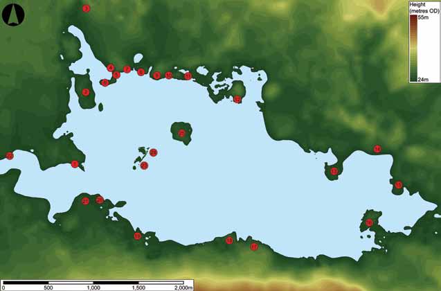
S2.7: Landscape surveys like those undertaken in the Vale of Pickering and the Severn Estuary should be carried out in other regions in order to understand the landscape context of Mesolithic activity.
S2.8: Techniques to assess ploughsoil lithic scatters need revisiting to assess their appropriateness in determining the location and character of Mesolithic archaeology.
S2.9: The relationship between surface scatters and the presence of in situ archaeology remains unsatisfactorily addressed, hampering the potential of ploughsoil lithic analysis. Finer-grained understanding of the extent and character of different lithic scatter sites might highlight the value of these.
S2.10: Better methods need to be found for identifying very high integrity sites dominated by lithic artefacts such as those recovered at March Hill (Spikins 2002), and known high-integrity sites need protection from repeated, destructive collection.
S2.11: Sites with organic preservation should be targeted in order to move beyond reliance on the small number of sites, such as Star Carr and Thatcham, Berkshire, which dominate interpretations of the period.
S2:.12: Similarly, features containing palaeoenvironmental information should be targeted to complement archaeological information, especially where the two datasets can be demonstrated to be contemporary or relevant for investigating landscape use and development through the Early Holocene.
S2.13: Coastal, estuarine and marine contexts also require the development of novel methodologies both to evaluate the archaeological resource and to mitigate for its destruction through development or erosion. Areas of poor data need to be targeted and archives need to be accessed through working in partnership with developers (eg wind farms) (see also the recently published maritime research agenda, Ransley et al 2013).