The Outer Thames Estuary NSPRMF study area extends from Clacton-on-Sea to Thanet in Kent and its geological history is dominated by the evolution of the Thames-Medway river system. The Thames-Medway river system originally occupied a much more northerly course in Norfolk but widespread glaciation approximately 450,000 years ago pushed the course of the Thames-Medway rivers further south to their current location, and during periods of lower sea-level, the Thames-Medway rivers extended offshore into what is now the Outer Thames Estuary.
Pleistocene terraces of the Thames-Medway rivers on land preserve a rich archaeological record showing people were repeatedly active in and around these rivers during the Pleistocene. Middle Palaeolithic artefacts have been dredged from now offshore extensions of the Thames-Medway rivers. These significant finds are thought to be located in an area where the Rivers Thames, Medway and Blackwater met creating an attractive environment for people and mammals
Offshore, a number of mammal bones have been recovered and the range of species represented indicates the Thames-Medway was inhabited by large mammals during cold and warm periods. The presence of hippopotamus indicates palaeolandscape features and deposits dating to the last interglacial period are preserved, which has been confirmed by luminescence dating.
Broad-scale mapping of the Thames-Medway rivers offshore has been undertaken and the entire system is complex with multiple cross cutting channels making it difficult to understand the age of these deposits. The limited dating that has been undertaken has focussed on organic deposits associated with the later stages of channel development which document an increasing marine influence under the influence of rising sea levels between approximately 8,400 and 7,700 years BP.
River terraces associated with the Thames-Medway system are known to preserve a rich and significant Palaeolithic archaeological records (Wymer 1999). Therefore, understanding the extension of this river system and associated tributaries offshores is of key archaeological interest. With this in mind, the Outer Thames Estuary was one of the regions studied through the ALSF-funded Regional Characterisation programme (Emu 2009; Dix and Sturt 2011). Development-led research for offshore wind and electrical interconnectors in the Outer Thames Estuary has been undertaken providing palaeoenvironmental and chronological data to understand landscape evolution in relation to human history (Maritime Archaeology 2013; 2017; Wessex Archaeology 2016; Brown and Russell 2019) (Table 10).
Table 10 Publicly available projects and published research since 2009 – Outer Thames Estuary
| Project | Location | Activity | Output | Reference |
| Thames REC | Outer Thames Estuary | Acquisition and integration of geophysical and core data | Palaeolandscape reconstruction and assessment of archaeological potential | Emu (2009) |
| ALSF Relic Palaeolandscapes of the Thames Estuary | Outer Thames Estuary | Interpretation of core data and dating | Palaeolandscape reconstruction | Dix and Sturt (2011) |
| Gunfleet Sands 3 OWF | Outer Thames Estuary | Interpretation of core data, palaeoenvironmental assessment and dating | Palaeoenvironmental reconstruction | Maritime Archaeology (2013; 2017) |
| Nemo Link Electrical Interconnector | Outer Thames Estuary | Interpretation of core data, palaeoenvironmental assessment and dating | Palaeoenvironmental reconstruction | Wessex Archaeology (2016); Brown and Russell (2019) |
| London Array OWF | Outer Thames Estuary | Interpretation of core data, palaeoenvironmental assessment and dating | Palaeoenvironmental reconstruction | Brown and Russell (2019) |
Major drainage reorganisation during the Anglian glacial period (MIS 12) had a significant impact on the evolution of the Thames-Medway river systems and palaeogeography of the Outer Thames Estuary (Bridgland 2006). Prior to the Anglian period, the Thames-Medway rivers occupied a more northerly course entering the southern North Sea via the present northern coast of Norfolk (Bridgland and Gibbard 1997; Ashton et al. 2010) and the pre-Anglian stratigraphy of the Outer Thames Estuary is represented by Red Crag which are Plio-Pleisotcene marine deposits (Stoker et al. 2011) that pre-date earliest known occupation of Britain.
The Anglian glacial period was the most extensive glaciation of the Pleistocene and saw ice sheets extending further south than at any time in the past 2.5 million years. The exact southern extent of the Anglian glaciation is currently debated. However, bathymetric data collected as part of the Thames REC show there are a series of enclosed deeps in the Outer Thames Estuary that have been interpreted as glacial meltwater channels (tunnel valleys) forming in close proximity to the Anglian ice margin during MIS 12 (Emu et al. 2009; Dix and Sturt 2011), suggesting ice extended further south than previously thought.
The British Geological Survey define the Quaternary stratigraphy in the Outer Thames Estuary as undifferentiated (Stoker et al. 2011). However, based on the results of the Thames REC, fluvial deposits associated with the submerged Thames-Medway river system likely dominate the Pleistocene and early Holocene sequence (Emu et al. 2009). Seismic data show the submerged Thames-Medway is characterised by complex cross-cutting channels that can exceed 40 m thickness in places and the presence of shallow gas suggests fine-grained or organic deposits may be preserved. Cores collected as part of the Thames REC were concentrated in a palaeochannel extending from Harwich Harbour and no ground-truth data was acquired within the submerged Thames-Medway system.
A post-Anglian chronological framework for the submerged Thames-Medway is largely underpinned by dating of the terrace sequence onshore (Bridgland 2006). No dating or palaeoenvironmental assessment has been undertaken on Pleistocene deposits and the focus of development-led investigations has been Holocene sediment sequences (Wessex Archaeology 2016; Haemagi 2017; Brown and Russell 2019).
Peat deposits preserved within palaeochannels located between 6 km and 12 km offshore of the north Kent coast were investigated to support the development of the London Array OWF and Nemo Link projects (Wessex Archaeology 2016; Brown and Russell 2019). The earliest sequence was dated to 10,170-9,760 cal. BP and pollen assemblage was dominated by boreal woodland taxa and ostracods suggest a freshwater environment. The influence of rising sea-level was recorded in later sequences dated to between 8,550-8,390 cal. BP and 7,840-7,670 cal. BP were palynology shows an increase in halophytic species indicative of saltmarsh environments. These organic deposits directly overlie bedrock and can therefore provide new sea-level index points (SLIPs) at depths of -34.38 m OD, -15.08 m OD and -8.12 m OD. Sea-level transgression was also documented in sediments within the Gunfleet 3 OWF with saltmarsh forming at 9,080-8,770 cal. BP (Maritime Archaeology 2017).
Limited paleoenvironmental datasets from direct sampling of sediments are currently available for the Outer Thames Estuary region (Table 11). Although extensive Pleistocene terrestrial deposits have been identified in the Outer Thames Estuary, including during recent investigations carried out in advance of Gunfleet Sands 3 OWF (Maritime Archaeology 2013, 2017), palaeoenvironmental assessment and analysis has focussed exclusively on Holocene sediments.
Palaeoenvironmental assessment and analysis of sediments infilling sediments in the area the Gunfleet Sands 3 OWF, located east of Clacton-on-Sea, identified early Holocene saltmarsh and estuarine environments with dry areas dominated by woodland of hazel and oak, with elm and alder carr (fen woodland) located in wetter areas, closer to channel margins (Maritime Archaeology 2017).
Further south in the Outer Thames Estuary, early Holocene paleoenvironmental records dating from 10,190 to 7,340 cal. BP have been identified (Wessex Archaeology 2016, Brown and Russel 2019). These records reflect progressive sea level rise marked by transitions from terrestrial landscapes, dominated initially by pine-hazel woodland but with an increasing prevalence of oak, elm and lime over time, to brackish water estuarine environments prior to full marine inundation (Brown and Russell 2019).
Table 11 Quaternary palaeoenvironmental studies of vibrocore data carried out in the Outer Thames Estuary region
| Project | Location | Publication Year | Age | Paleoenvironmental proxies | Reference |
| Gunfleet Sands 3 OWF | East of Clacton-on-Sea | 1017 | Plant macrofossils Insects Pollen Diatoms Ostracods Foraminifera Molluscs | Maritime Archaeology (2013, 2017) | |
| Nemo Link Electrical Interconnector | North Kent | 2019 | Early Holocene | Plant macrofossils Pollen Charcoal Ostracods Foraminifera | Wessex Archaeology (2016), Brown and Russell (2019) |
| London Array OWF | North Kent | 2019 | Early Holocene | Plant macrofossils Pollen Charcoal Ostracods Foraminifera | Brown and Russell (2019) |
In the Outer Thames Estuary region, study of historic trawled finds (Bynoe 2014, Bynoe et al 2016) has identified a discrete area located off the Tendring Peninsula which has produced terrestrial mammalian fauna dominated by Middle and Upper Pleistocene species. The dominance of woolly mammoth and wholly rhino amongst this material has been suggested to indicate principally a MIS 7 to MIS 3 (240–29 Ka) date (Bynoe 2014, Bynoe et al. 2016). The presence of obligate temperate species, including straight-tusked elephant, hippopotamus and narrow-nosed rhino are indicative of interglacial conditions. The inclusion of hippopotamus amongst species is suggestive of an MIS 5e date (130–116 ka); the potential presence of deposits of this date in this area is further suggested by an OSL date of 116±6.5 kya on sediments from the same broad location (Dix and Sturt 2011: 110).
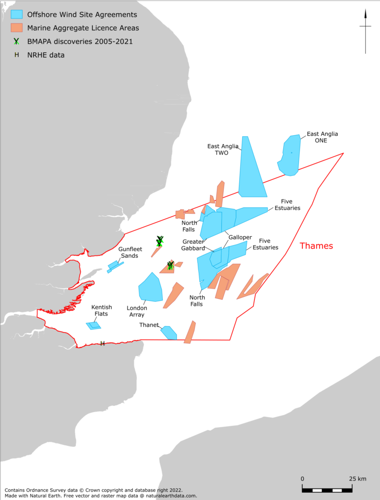
Since 2009 consistent finds of terrestrial mammalian fauna has been reported through the BMAPA protocol from aggregate licence Area 447, which is located off the Tendring Peninsula (see Figure 5). These finds include two chronologically diagnostic species of mammoth: southern mammoth indicative of a pre-Anglian age and woolly mammoth of Middle to Late Pleistocene date. Historic and recent faunal datasets therefore both indicate that fossiliferous Pleistocene deposits of multiple ages are present in the general area off the Tendering Peninsula, and Area 447 specifically. It is notable that Area 447 has also produced significant Middle Palaeolithic archaeology and Pleistocene fauna dredged as part of the Clacton to Holland-on-Sea beach replenishment scheme (Bynoe 2018). The faunal remains in this assemblage are dominated by Middle/Upper Pleistocene species such as woolly mammoth, woolly rhinoceros and horse (Bynoe 2018).
The preservation of likely Pleistocene alluvial deposits in this area has been demonstrated (Bynoe 2017). The Tendring Peninsula and Area 447 are in an area where both the confluent pre-Anglian River Thames and Medway and post-Anglian confluent Rivers Thames, Medway and Blackwater would have been located (Bridgland and D’Olier 1995, Bridgland 2003, Sturt and Dix 2009, Dix and Sturt 2011). Consequently, it is highly likely that submerged Pleistocene deposits relating to these drainage systems are present in this area.
Pleistocene and Holocene deposits of the River Thames and Medway, which terrestrially have produced large amounts of Palaeolithic and Mesolithic archaeology (Wessex Archaeology and Wymer 2009, Wessex Archaeology and Jacobi 2014), are known to occur in the Outer Thames Estuary (Sturt and Dix 2009, Dix and Sturt 2011, Brown and Russell 2019).
Prehistoric archaeology identified since 2009 outside the intertidal zone and below MLWS tide consists of Palaeolithic archaeology recovered by local collectors from aggregate deposits as part of Clacton to Holland-on-Sea beach replenishing scheme (Bynoe 2018). In addition to faunal material, this comprised over 200 Levallois flakes and cores. Although not currently published in detail, this represents the single largest assemblage of Middle Palaeolithic material recovered from a British context since the early 20th century. It has been established that aggregate used as part of the replenishment scheme was dredged from marine aggregate Licence Area 447 (Figure 5). Area 447 is located in an area where the post-Anglian (<MIS 12; <424 kya) confluent Rivers Thames, Medway and Blackwater would have been located (Bridgland and D’Olier 1995, Bridgland 2003, Sturt and Dix 2009, Dix and Sturt 2011). Consequently, it is highly likely that this Middle Palaeolithic assemblage originates from submerged Pleistocene deposits relating to this drainage system.