by Caron Newman
With contributions by David Cranstone, Chris Crowe, Andrew Davison, Julie Edwards, Geoff Egan, Andrew Fielding, Mary Higham, Elizabeth Huckerby, Mark Leah, Jennifer Lewis, Mike Morris, North West Medieval Pottery Research Group, Michael Nevell, Rachel Newman, Richard Newman, Rob Philpott, Norman Redhead, Peter Ryder, Nick Thorpe, John Trippier, Simon Ward, Rhys Williams, Ian Whyte and Jason Wood.
The region has benefited from a number of major research initiatives. These include multi-disciplinary investigations at Norton Priory, the moated site of Old Abbey Farm Risley, the Rows in Chester and the deserted village of Tatton. These sites all lie in the south of the region, illustrating one of a number of biases and challenges inherent in the nature of the region’s settlement pattern and the character of its geography. Indeed, the most recent synthesis of Medieval landscape in the North West does not include Cumbria in its definition of the region (Higham 2004b). Whilst the degree of nucleation and dispersion within the settlement pattern is not entirely geographically related, there are clear differences between the Medieval settlement geography and typology in Cheshire to that in Cumbria. The intervening area to an extent shades from the south to the north. This general view is complicated, however, by a broad east to west settlement trend reflecting a movement away from lowland to upland (Winchester 1993) and by numerous more local variations. In addition archaeological research into both Medieval rural and urban settlement is hampered by the partial destruction of the evidence through 19th and 20th century urbanisation and industrialisation, removing both above and below ground evidence in a belt incorporating much of north Cheshire, south Lancashire, Merseyside and Greater Manchester. Documentary-based reconstruction of Medieval landscape in Merseyside (Lewis and Cowell 2002), along with Lewis’s work (2000) on surviving earthworks of the West Derby Hundred, and Nevell and Walker’s research (1998) into the buildings of Tameside, have shown how research can be productive even in these areas. In eastern Lancashire much of the Medieval settlement pattern is obscured by later development, and here the evidence is primarily presented by historical research completed 50 years ago or more (Tupling 1927; Shaw 1956).
The region’s SMRs for the Medieval period are dominated by rural sites. In total there are around 6500 records for the Medieval period, of which over half are rural sites. Many of the SMR entries for urban sites relate to Chester and Carlisle, particularly defensive and ecclesiastical features. 21% of the entries can be considered higher status sites, either castles, defensible buildings, moated sites or parks. Around 550 SMR entries, or 8.5% of the total, are findspots. In addition, the Portable Antiquities Scheme database holds another 906 findspots for the North West (March 2006), most of which (456) are from Cheshire and Lancashire (264).
Research has concentrated traditionally on nucleated villages and moated sites. Only in Cumbria has there been much archaeological research into dispersed settlements and these have tended to be transitional, seasonally occupied habitations (Lambert 1996; Hair & Newman 1999). In Cumbria and elsewhere in the region valuable research into such settlements has been undertaken by historical geographers (Atkin 1985; M C Higham 1996; Winchester 2000b). Only for the very late Medieval period in the uplands has permanent dispersed settlement been investigated in detail (Winchester 2000b), though more limited historical investigations have been undertaken of Cheshire’s dispersed settlements (N J Higham 1987). Excavation for the most part has been concentrated in the south of the region, especially on moated sites. One of the larger excavations of Medieval settlement remains undertaken in the region is at Tatton Park (Ch) (N J Higham 2000). Very few of the site comparisons made in the publication of this site are from the region, however, because most comparable projects have been undertaken elsewhere, and the region lacks a major archaeological research project such as Wharram Percy in Yorkshire, Raunds in Northamptonshire or Shapwick in Somerset (Wrathmell 2003, 364).
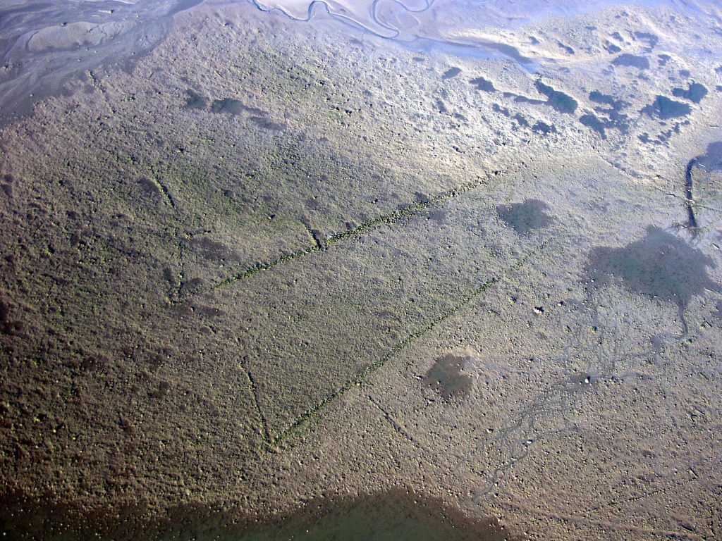
With the exception of Tatton (Ch), there has been little attempt to place settlements within their wider Medieval landscape or to examine the interrelationship of settlements and their agricultural systems. A territorial framework not only provides a context for understanding Medieval settlement but can provide the research structure within which a settlement or settlement pattern can be investigated (Harvey 1996, 34). At Tatton, the excavations lay at the core of a project which examined the development of the manor and its settlements in relation to the tenurial exploitation of the landscape. Multi-period in scope and multi-disciplinary in technique, the project was able to place the nucleated settlement that developed at Tatton Old Hall in the 13th century within a continuum of landscape development (N J Higham 2000). Elsewhere, the lack of archaeological study of the wider Medieval landscape has meant that agriculture, for example, has remained the province of historians and historical geographers (Singleton 1963; Watson 1989; Youd 1962), although the county-based Historic Landscape Characterisation (HLC) programmes have mapped elements of Medieval field systems. Similarly, there have only been a few archaeological investigations of other Medieval land-use activities such as fishing and hunting. Deer parks, for example, are a common feature across the North West region, but few have been studied from an archaeological perspective. They can be identified as landscape features within the HLCs, and at Dalton (C), part of the park boundary has been traced on the ground (R Newman pers comm). Using documentary evidence and field observation, the boundary of Burton-in-Lonsdale Chase, partly within the Forest of Bowland, has also been traced (M C Higham 1994). Within Morecambe Bay, a complex series of fishtraps has recently been uncovered at Cowp Scar (C; Fig 5.1). The structures comprise stone and timber walls, with ponds and sluices, covering an area of approximately 275m by 350m, with further stone structures still being revealed. Radiocarbon dates suggest that some of the traps were operating in the 14th century, but continued in use into the post-Medieval period (J Manning pers comm).
The issues and approaches put forward by the Medieval Settlement Research Group are relevant to the region and form a context within which to assess Medieval rural settlement research within the region thus far (Wrathmell 2003). These include: the necessity to recognise the significance of dispersed settlements and avoid an over-concentration on nucleations; the study of settlements within their estates and the context of their territories; multi-period research and a focus on periods of transition; the study of local vernacular architecture, and finally, interdisciplinary programmes of research. All these issues had already contributed to research in the region, including an outline research agenda for Medieval settlement studies in Lancashire (R Newman 1996a, 120-3). They were at least partially embodied in the Tatton Park project (N J Higham 2000), and informed the approach to the investigation of the moated site at Risley (Ch) (Heawood et al, 2004).

The recent mapping of rural settlement in the 19th century, as depicted on the first edition Ordnance Survey maps, has allowed settlement density, nucleation and dispersion to be portrayed (Roberts & Wrathmell 2000a) and appears representative of the Medieval settlement pattern. This shows large tracts without settlement in the uplands and a generally high density of dispersed settlement elsewhere. Areas of dispersed settlement have been correlated with areas of surviving woodland in the late Anglo-Saxon period (Roberts & Wrathmell 2000b, 87-8), which correspond with the ancient landscape zone defined by Oliver Rackham (1986) and contrast sharply with the planned landscapes of Roberts and Wrathmell’s Central Province in the Midlands. Certainly, the North West region contained many forests and chases, not necessarily wooded, suggesting that the model of a closely planned landscape of open fields around a nucleated village centre is not generally applicable. Away from the uplands the only areas where dispersed settlement density is not high or very high is along the Solway coast and in parts of west Cumbria (Roberts & Wrathmell 2000a). Even so, in those parts characterised by dispersion, the settlement pattern was often mixed with significant numbers of nucleated village-type settlements (Fig 5.2) existing alongside isolated farms and small hamlets, for example in the Manchester area, the Wirral, the West Lancashire Plain, along the Morecambe Bay littoral and in the Eden valley. Whilst many hamlets and farms were associated with curvilinear field enclosures, characteristic of assarting, townships characterised by dispersed settlements, particularly in the Greater Manchester and east Lancashire areas, were often based around commonfield systems (Fig 5.3), usually centred on one of the principal Medieval landholdings.
It has taken some time for this picture of the settlement pattern in the region to be developed, as the North West was long considered an area of little interest. Beresford and Hurst’s national maps of deserted Medieval villages showed only a small group in eastern Cumbria, a couple of sites in Bowland and two in Cheshire (Beresford & Hurst 1971, 34). Yet the prevailing view that Medieval peasant settlement consisted primarily of villages was reflected in a previous attempt to assess archaeological knowledge and research in northern England (Clark & Gosling 1976). There was no consideration of dispersed settlement and the research need was seen as a requirement to move the emphasis away from deserted villages towards existing villages of Medieval origin (Clark & Gosling 1976, 53). This has been done in the last few years in Cumbria, as development threats have been addressed by limited excavations within empty single crofts, especially in the Eden district. Remains identified by such excavations are often ephemeral or do not form coherent structures, such as the features excavated at Hackthorpe (C), where it was not possible to associate Medieval pottery with securely dated contexts (Johnson 2004). Elsewhere such opportunities have often been limited by significant post-Medieval expansion and infilling. Regionally the few projects that have been undertaken have generally concentrated on an extraordinary subset (the failures) of an unusual settlement type (the nucleated village).

The villages of the north of the region exhibit considerable elements of planning, stimulated by a powerful, presumably lordly, authority, for example in the Eden valley (Roberts & Wrathmell 2002b, 174). The villages generally consist of two rows, often with a green and a highway between. The strip-like crofts extend away from the central communal village space and often there is a back lane facilitating access to the rear of the crofts (Roberts 1990). Such settlement characteristics can be seen elsewhere in Cumbria and north Lancashire, such as Shap and Hale in Cumbria and Yealand Redmayne in Lancashire. Their genesis has been placed in the late 12th century as part of a consolidation of Anglo-Norman power (Roberts 1990). In west Cheshire too, nucleated, planned villages are characteristic of the area. Many retain typically Medieval features such as narrow plots fronting onto a street with the remains of back lanes separating them from ridged and furrowed fields. Other villages were based on manor houses, such as Bruera, where a moated site stands opposite a small 12th century church, a few remaining houses, abandoned house platforms and fields with ridge and furrows. Similarly, Baddiley (Ch) has a moated site with associated enclosures within a large area of ridge and furrow, and which may be a lost grange of Combermere Abbey. Cheshire villages also have greens, such as at Caldecott Green, where the green consists of nothing more than a strip of varying width on each side of the lane. Hetherson Green, near Malpas, is a linear settlement along a lane, where an unusually wide verge suggests the green was probably on a sharp bend. Wide verges further along the lane suggest a second green, and it may be that Hetherson Green developed from an original polyfocal settlement one element of which has been lost. This area of Cheshire has some of the best surviving ridge and furrow in the region, with excellent examples still to be seen at Hatton, Shocklach and Bruera.
In the Eden valley, researchers have been attracted to the well-preserved earthworks of nucleated villages (Roberts 1993a; 1993b; 1996), mainly undertaking topographical analysis, with little excavation. Only at Newby has the below-ground evidence been sampled to any extent. This excavation remains unpublished and the only Medieval village excavation submitted for publication in Cumbria is the recent work at Rickerby, near Carlisle (Masser forthcoming). Other significant excavations of nucleated settlements, apart from Tatton, have been few. Medieval buildings at Easington in the Hodder valley (L) were investigated over a number of seasons in the late 1970s and 1980s, but remain largely unpublished. Very little work has been undertaken on rural structures in Merseyside or Cheshire. At Fazakerley (M) a single croft was excavated in the 1990s, but is unpublished (Wright 1996). At Irby three buildings constructed using dwarf foundation walls were excavated, and at Brunt Boggart, Tarbock a probable cottage was excavated (Cowell & Philpott 2000, 126-32), with a suggested 13th or 14th century date (Speakman 2000). Most recently, research excavations at Mellor (GM; Fig 5.4) have uncovered four rows of postholes interpreted as part of a Medieval aisled hall, dated to between the 11th to 15th centuries (Mellor Archaeological Trust 2006). The settlement at Meols is the chief source of comparative information on Medieval buildings in Wirral. Unfortunately no plans or photographs survive, but antiquarian accounts suggest there were three distinct types of structure. The first consisted of rough stone foundations, into which upright timbers were set, the second consisted of clay walls of rectangular buildings, and the third were simple wattle constructions. Clay walled buildings, known as clay dabbins, are also found in north Cumbria in the post-Medieval period, but documentary sources and some dating evidence suggests they were once widespread at least from the late Medieval period (Jennings 2003, 33-50).
One of the most significant and widely distributed categories of buildings from the late Medieval period is the cruck-framed timber building It is one of the earliest vernacular building traditions to survive in the North West, of which in 1981, 346 examples were known in the region. Within the Mersey Basin, where the status of the building can be established, 27% of the known crucks are associated with manorial estates and 36% with freeholdings, indicating that cruck-frames were often used in the construction of high status buildings (Nevell & Walker 2002, 12-4). The 13th century vicarage in Poulton-le-Fylde, Lancashire, for example, appears to have been a cruck-framed open-hall (Thornber 1837). Few detailed, local vernacular studies, such as those of McClintock and Watson (1979; 1995), have been undertaken. Of the 70 cruck buildings within Greater Manchester, a few have been dated by dendrochronology; timbers at Newton Hall have a 14th century felling date (Burke & Nevell 1996, 5) a cruck from Kersall Cell has a felling date range of around 1515, and Staircase House has a felling date range of 1459-60. Apethorn Fold in Hyde, Taunton Hall, and Stubley Old Hall in Rochdale all have 15th century dates. Documentary and other evidence indicates that this Medieval building tradition persisted well into the post-Medieval period in the North West, unlike other regions.

A number of open halls still survive in the North West, such as Adlington Hall in Macclesfield, Ordsall Hall in Salford, Smithills Hall in Bolton, and the 14th century Baguley Hall in Wythenshawe which is the earliest dated surviving timber manorial hall in the region. Archaeological work on late Medieval halls in the region has been sporadic, largely focused on National Trust properties. An important survey accompanied the renovation works at Little Moreton Hall, particularly the 16th century South Range (Fig 5.5). At Sizergh Castle, an RCHME survey transformed understanding of the development of the house, especially the extent and phasing of the 16th century works to the building (National Trust 2000, 44-45). A survey of the timber frame of Rufford Old Hall was carried out in advance of repairs to the roof structure. Stylistic and other evidence suggested a date in the very late 15th or early 16th century for the main hall and resulted in a reinterpretation of its building history (LUAU 1996b; 1996c). Ongoing repair work at Speke Hall, Merseyside, has revealed a complex sequence of building history still to be fully interpreted; survey and excavation has also taken place at Lydiate Hall and at Samlesbury Hall (LUAU 1997d). Altogether, a significant body of new work has resulted from recording and repair programmes for the North West’s late Medieval and 16th-century secular architecture but this remains to be brought together and properly assessed. Much of the building recording work has not been reported or published.
Medieval settlement earthworks have attracted conservation designations and have acted as a focus for research, although rare outside the Eden and Ribble valleys. There has been relatively little field investigation of settlement earthworks but there are indications that many were actually abandoned in the post-Medieval period. For example the earthworks of the scheduled monument at Stock in Lancashire, classed as a deserted Medieval village (R Newman 1996a, 118), represent 19th century desertion (Darlington 2003, 80-2). Similarly at Rufford New Hall park (L) earthworks of buildings and enclosures assumed to be Medieval were shown during desk-based research to represent early 19th century emparking (Egerton Lea 2002a).
The study of dispersed settlements is a growing area of research but aside from Lewis’s work in south-west Lancashire, there have been few large-scale co-ordinated programmes of research into dispersed settlements in the region. Nationally there are still relatively few excavations of dispersed settlements (Lewis et al 2001, 13). Excavations at Stephenson’s Scale (C) uncovered a double-walled farmhouse, the arrangement of which may have been a combination of storage facility and animal pen. Nearby, an egg-shaped, stone-walled structure was interpreted as a longhouse. Phosphate analysis suggested that the upslope area was occupied by people, whilst the lower part was occupied by animals. Small sherds of pottery and radiocarbon-dating indicated that it was occupied during the 12th to 14th centuries. An early investigation of part of a dispersed settlement pattern at Ashbeck Gill, near Sedbergh (C), was little considered because it lacked a research context (Wrathmell 2003, 364). The building had a rectangular plan with drystone-built walls, and finds suggesting occupation in the 14th to 16th centuries. The settlement context for the site is provided by the existing dale-side dispersed settlement pattern of the area (Addyman et al 1963, 33). This highlights one of the difficulties in analysing the development and nature of Medieval settlement patterns in the region. Much of what may have existed in the Medieval period may be retained by the modern settlement pattern (see Winchester 2000b) and is neither abandoned and available for investigation nor visible as earthworks. The location and small size of dispersed settlements mean they are not as easily identifiable as larger deserted nucleations and are more easily rendered ‘invisible’ by later land use.

Excavations at Powsons Farm near Tebay (C), examined the site of a known upland farmstead from the 16th century, but found that the house was of similar dimensions and dry-stone construction to buildings elsewhere in the region considered to be upland Medieval shielings. It was considered by the excavators that the single-celled building originated as a Medieval seasonal dwelling before becoming a permanent farmstead. Dating evidence was poor, as most artefacts were derived from the topsoil and none were diagnostically Medieval (Hair & Newman 1996, 189-90). Whilst it may be true that throughout much of the North West rural Medieval sites produce relatively few artefacts, particularly pottery, it seems excessive to claim that ‘excavations within the region have demonstrated a relatively aceramic culture in rural areas throughout the Medieval period and until the 18th century’ (Hair & Newman 1996, 189). No other non-moated Medieval dispersed farmsteads have been archaeologically investigated within the region in any detail. Plant and animal remains from excavated sites have also not been retrieved or studied in any quantity, so very little is known about the range of crops grown, and how trends evolved over time, nor is there any information about the physical and genetic types of livestock farmed.
The expansion of settlement and cultivation during the Medieval climatic optimum has been identified in south-east Scotland, with a subsequent progressive retreat from the 14th century linked to the climatic deterioration of the Little Ice Age. Subsequently this model has been applied to the British uplands generally (Parry 1978). Within the North West, settlement expansion led to widespread assarting, land improvement and new enclosure (Fig 5.6). Although different chronologies of settlement expansion and retreat can be identified at local scales (Appleby 1978), more research is needed to establish broader regional patterns. The deteriorating climatic conditions can be seen in the pollen and plant macrofossil record from northern Cumbria, with reductions in agricultural indicators and the identification of wetter conditions on the mire surface of Bolton Fell Moss between cal AD 1258-1395 and cal AD 1298-1428 (Barber 1981, 191) and Burnthill Moss (Tipping 1995). In the Cumbrian uplands the wetter conditions may have contributed to major episodes of erosion at Seathwaite, Borrowdale (Wild et al 2001) and Langdale in the Howgill Fells (Harvey et al 1981; Hodgkinson et al 2000, 323-24).
The North West has shown high potential for investigating environmental change and the interrelation of climatic, human and ecological factors, during the Medieval period. It has suitable deposits that contain proxy indicators of past environments and has a history of detailed, often pioneering, palaeo-environmental investigations. It is a region where many types of agricultural activity are close to their margins for economic viability and where many species of flora and fauna are also at the edges of their geographical distributions. This last factor means that land-use patterns and distributions of wild plants and animals are susceptible to changes in climate or human activities even if those changes are relatively slight.

There are now over 500 known sites, of which 24% are scheduled, though some soil and cropmark sites may still remain undetected (Fig 5.7). In Greater Manchester alone, there are 63 certain and 22 possible moated sites. Of these, the Medieval halls survive at Clayton Hall and Ordsall, whilst excavated moated manor houses include Timperley Old Hall in Trafford and Denton Old Hall in Tameside (Nevell & Walker 2002). At least 80 sites (15%) have disappeared through urbanisation, industrialisation and intensive agricultural regimes, and the real figure is probably higher. In the north of the region the lack of moated sites is mirrored by a greater number of fortified and defensible tower houses and halls with towers or tower-like wings. Some were surrounded by moats but they were more often enclosed by barmkins (defensive walls). In the North West, moated sites are usually associated with dispersed settlements, although they can occur within nucleated settlements around some higher status sites, especially manorial centres. They are more often found in isolated situations usually within dispersed settlement landscapes of farmsteads and hamlets (Lewis et al 2001, 114). The majority (84%) are considered to be moated homesteads. In Cumbria there is a notable group of moats situated on hill tops. The precise nature of these is uncertain and they may not have had domestic occupation on their platforms.

Most moated sites lie below 150m OD, many on the poorly drained lowlands of the Solway Plain and south Lancashire, and mostly on boulder clay across the region as a whole (Lewis 2000, 106-107), although there are a small number of rock-cut moats. The majority are single platforms, but 8% comprise either more than one enclosure or elaborate complex of platforms and associated ditches. The principal platforms tend to be rectangular or square, with a small number of rounded or oval, trapezoid or polygonal forms. The plan forms of sites in south-west Lancashire have been published (Lewis 2000, 112-117) and may be compared with those from elsewhere in England (Taylor 1978, 6-11). Fishponds have been noted at 42 sites; and other ancillary features include leats, gatehouses, bridges and causeways, chapels and farm buildings. The survival of embanked platforms in Cheshire and Cumbria may be a consequence of farming regimes which have favoured pastoralism.
Only about 12% of sites have been surveyed in detail, and RCHME surveys have been undertaken in Cumbria and Cheshire where Reynolds and Cocroft have also done some important work (1990; 1991). Occasional use of geophysics has had limited results. Archaeological approaches, dominated by developer-funded work, have been limited to the ditches and platforms. There has been little wider consideration of the social aspirations of the owners of moated sites or their impact on landscape management (Roberts & Wrathmell 2002a, 58). There has been archaeological investigation at 69 sites, ranging from small-scale evaluations and watching briefs to extensive open area excavations but most saw trench excavation in the 1970s and earlier.
Moat creation is thought to date principally from the 12th to 13th centuries (Roberts & Wrathmell 2002a, 58). With rare exceptions, the chronological relationship between buildings and their moats is far from clear. Excavation has shown that buildings at Tanner’s Farm were destroyed and new buildings raised when the moat was created in the 15th century (Lewis 2000, 211-212). At Denton a new wing was builtover the moat in the 16th century (Nevell & Walker 2002). At Speke Hall, excavation and dendrochronological dating of the standing building have shown successive occupation, indicating that the present dry moat may date from no earlier than the 16th century (Higgins 1992; Lewis 2000, 345-346). Dendrochronology can play a role in dating standing structures adjacent to empty platforms, with a potential for establishing a terminus ante quem for abandonment of the platform. At Bewsey, a radiocarbon date suggests occupation in the early 12th century but timbers discarded in backfill of a massive ditch were of 16th century date (Lewis 2000, 204-205) demonstrating that here, as on many other sites, the platform buildings were modified and adapted on several occasions. There is no evidence for standardised building plans, forms or functions. These appear to be locally developed, with buildings constructed from local materials. Timber-framed buildings predominated in the lowlands, though dwarf walls might sometimes be used. Stone was probably favoured in the Cumbrian uplands. Timber and stone bridges are known across the region. Resources have not always been available for analysis of environmental evidence from moat fills though macrofossil remains from Bewsey were indicative of running water (Innes & Tomlinson forthcoming). At Speke Hall insect remains suggested that the early ditch found beneath the mid-16th century west range may have been grazed after it had been filled in (Kenward & Tomlinson 1992, 78).
One of the best researched moated sites in the region is Old Abbey Farm, Risley (Ch; Fig 5.8) which is associated with agricultural expansion in the 13th century. The project is unique in the region, involving the study of a moated farmstead from fully standing buildings which were demolished archaeologically through to the total excavation of the moat’s platform. The earliest elements of the house formed part of a late 13th century timber-framed open hall which had been successively remodelled. Without an intensive study of a type rarely possible on most sites it is unlikely that the origins of the house would have been recognised, since the evidence consisted of a few reused Medieval timbers, an excavated beaten clay floor and some excavated possible padstones for an aisle (Heawood et al 2004). The artefactual evidence for Medieval occupation was also slight, with only seven sherds of Medieval pottery recovered, as well as three fragments of late Medieval leather footwear and possible Medieval wooden objects recovered from moat deposits (Heawood et al 2004).
Many publications are only available in summary form in various journals, as grey literature, or the data has yet to be fully processed. Limited surveys of Cheshire’s and Great Manchester’s moated sites have been published (Nevell & Walker 2002; Tindall 1985; Wilson 1987; Williams 1997). The records of many older excavations do not survive or fall short of modern standards, such as West Derby Castle (Droop 1928; Droop & Larkin 1928) and Mote Hill (Kendrick 1853); and field records for Sefton Old Hall (Lewis 1981) and The Old Hutt (M) (Wrathmell 1992) are of limited value in interpreting the evidence.

One of the most distinctive forms of upland settlement was the seasonally occupied shieling, and many have left archaeological traces in the form of earthworks and associated dykes. The structures may vary in complexity, form and function but in general consist of buildings for habitation and work activities (Fig 5.9) related to the seasonal exploitation of upland resources, most commonly summer grazing. The archaeological remains of these structures can be isolated, closely grouped or loosely clustered. The nature of the landscape exploitation initiated through these sites may date from the 10th or 11th centuries (Ramm et al 1970, 3) and some may have been consistently seasonally occupied from the early Medieval period into the 12th century (Roberts 1993b). Others are of later Medieval origin and continued to operate well into the post-Medieval period. The social and estate context of these settlements also seems to have varied considerably. Some were part of long distance transhumance systems where isolated summer grazings were being exploited from distant and separated estate centres, as has been proposed for parts of the Howgill Hills (Hair & Newman 1999, 156). Others lay within the main block of territory of an estate or township but were too distant from the principal steading for daily movement, as has been proposed for shieling sites at Kentmere in the Lake District (Atkin 1991, 76).

Recently there have been important historical studies and landscape surveys that have greatly added to our knowledge of upland settlement (Winchester 2000a; 2000b; Bowden 1996). These, however, have concentrated on documentary sources and survey of earthwork archaeological remains, which rarely allows sites to be dated. Excavation and detailed topographical analysis have been limited, and most have been largely focused on Cumbria (eg Richardson 1979). There has been little investigation of the variety of building and settlement forms in relation to location, function and period as well as the material culture and thus interpreted lifestyles of the inhabitants.
By the 12th and 13th centuries the uplands were dominated by cattle rearing, through the establishment of purpose-built cattle ranches known as vaccaries, often in areas of royal forest or baronial chases. Forests were essentially large tracts of land best suited to extensive demesne pastoral exploitation, where deer were carefully managed to produce venison, skins, antlers and bones. Alongside the deer, cattle were reared in vaccariae (cattle farms) located in the forests.
The vaccaries gave rise to some very characteristic landscape features and settlement forms, which can still be recognised in the modern landscape, for example in the Forest of Bowland, where they were located in side valleys near large areas of hill grazing. The centre of a vaccary was essentially a hamlet, with several dwellings and associated farm buildings clustered together. The settlement was often in a girdle pattern round the arable area, and footpath and bridleway evidence often points to a long-established focal point, the vaccary centre or headquarters. Individual vaccaries have been the subject of documentary studies (Winchester 2003) and the settlement pattern formed by them has been analysed (Atkin 1985, 177-9; 1994).
The vaccary of Sykes, in the Trough of Bowland was largely governed by topography, with the settlement in the valley floor, and arable land behind the settlement. Vaccaries had at least one stock funnel or drift way, where animals were brought down from moorland. These stock funnels tended to have curving boundaries, which allowed for the more controlled movement of animals. The presence of large holly trees can indicate a Medieval boundary, as the trees were used for feeding cattle in the worst of the winter. Some vaccaries, such as Sykes, developed into small hamlets in the 16th century but others survived as isolated farms (Winchester 1993, 23-7). The settlement form of the vaccary has been the subject of only one archaeological investigation, at Sabden Fold, the site of Goldshaw Booth vaccary, where structures were uncovered, but little dating evidence (M C Higham 1968). In Bowland, the remains of the Medieval vaccaries appear have been incorporated into the later settlement pattern. Vaccary farming appears to have been in decline by the later 14th century (Porter 1980, 27).
In some uplands, particularly on limestone, sheep rearing took place in bercarii. The settlement patterns are similar to those of the vaccaries, and sheep folds/sheep shelters still survive on the upland grazing. In some former bercarii the remains of sheep huts can be identified within the in-bye land. These were often owned by the monastic houses and used as summer grazing as part of a transhumance system (McDonnell 1988, 9). Thus rather than being managed from a permanently occupied farm, they may have been run from seasonally occupied shielings (Hair & Newman 1999, 156). Horse rearing, too, seems to have taken place in the limestone uplands, including within deer parks. Other types of specialist settlements such as fishing villages and hamlets have not been examined. Elsewhere the value of studying such settlements has begun to be demonstrated (Gardiner 1996) but despite the importance of the marine environment to the region, such research is hampered by later coastal development. For example the fishing hamlet of North Houses, known to exist on the Fylde coast in the early 16th century, grew to become Blackpool (Egerton Lea 2003a).
Granges were scattered throughout the North West, including some moated sites such as those on the Wirral (Lewis 1991, 96-7). A few formed elements of nucleated settlements but the majority appear to have been isolated farmsteads. Very few granges in the North West have been studied archaeologically, apart from some of the moated sites of Merseyside and Cheshire, such as the site at Bromborough which belonged to St Werburgh’s Abbey in Chester (Chitty & Warhurst 1979). With regard to the establishments of the military orders, the accepted view, based on the documentary record, was that the North West lacked preceptories (Gilchrist 1995, fig 34). Recent survey work in advance of the upgrading of the A66 trunk road has shown that Temple Sowerby in Eden was not only the site of a Knights Templar’s preceptory but may also have had an Hospitaller’s establishment nearby (NAA 2003).

There were relatively few towns in the North West in the Medieval period. As a region it was relatively thinly populated and, outside Cheshire, underdeveloped economically in comparison to other areas of England. Chester was the only city in terms of size and regional status, and was described as such in Domesday Book. Carlisle was also important, since like Chester it was the seat of a bishopric and also had a strategic position on a national boundary, in this case the Anglo-Scottish border. Defensive walls were built at both Chester and Carlisle (Fig 5.10). Few other towns were of any significance at a national scale and the overwhelming majority were chartered boroughs, deliberate creations of the 13th to 14th centuries, with a characteristic planned layout. Only a sample are recorded in West’s (1983) composite list of previous national surveys of boroughs, and smaller Medieval towns like Warton and Hornby in Lancashire, are not included. A number of urban communities, though not chartered boroughs, functioned and had the physical characteristics of towns, for example, they held markets, exhibited similar plan components to boroughs and sometimes had friaries. The larger market villages do not seem to have been urban (White 1996, 127), but work on Extensive Urban Surveys (EUS) suggests they had at least a proto-urban function and appearance, for example Blackburn, Colne (L) and Ulverston (C).
Relatively few excavations have been undertaken in Cumbria’s towns, other than in Carlisle, where excavations in the northern Lanes identified well-preserved sequences from probably the late 12th to the early 16th centuries, including timber and later stone-footed buildings (Zant forthcoming b). The lanes from which this part of the city took its name have been shown to date from the 14th century. Similarly, excavations on Castle Green uncovered well-preserved stratigraphy of 12th to 13th century date, including the remains of timber buildings to the north of the city ditch, and well-preserved organic material within the ditch itself. To date, however, much of this material remains unpublished.


Small-scale work has been undertaken in Egremont (R M Newman 1988a), Cockermouth (Leech forthcoming) and Penrith (Newman et al 2000), but it is Kendal that has received the most attention since the mid-1980s (Fig 5.11). Two relatively large areas have been excavated, one on either side of Stricklandgate (R M Newman forthcoming) and a further major area in Highgate, together with two further areas to the south. Where street frontages have been available for investigation, evidence has been produced for a planned layout from the 14th century or earlier. At Stricklandgate, a complete sequence of structures from the 14th century onwards were recorded some 13m from the street frontage (Hair & Wild unpublished; R M Newman forthcoming). Medieval buildings were built of timber or cob walls, and stone was not introduced until the early post-Medieval period. Some evidence for industrial use has been found, including a hearth close to the street frontage of Stricklandgate, and a kiln of unknown purpose close to the back of a burgage plot.
In Lancashire, Lancaster has been the subject of the most recent archaeological interventions, although work has concentrated on the Mitchell’s Brewery site in Church Street, which had been disturbed by later activity. This demonstrated that many of the Medieval plot boundaries echoed those of the Roman period, never deviating more than 1m, and suggesting some continuity of use. The final Roman structures were stone-built and apparently survived to an extent which dictated the layout of the Medieval town (Howard-Davis et al forthcoming). Excavations on the site of the market suggests that this area lay at the southern extremity of the town, as shown on Speed’s map of 1610 (Drury forthcoming). After Lancaster, Ormskirk has probably had the most archaeological excavations undertaken in Lancashire (ten since 1992 at the time of writing) but all are small-scale, limited investigations lacking in a research context. In total they add little to the history of the town as recorded by Philpott in 1988. In Manchester, excavations have been undertaken on the defensive ditch, known as Hanging Ditch. This enclosed a promontory overlooking the confluence of the rivers Irk and Irwell, and encompassed both the castle and church that formed the historic core of the Medieval settlement (M Nevell pers comm.). In Merseyside, archaeological investigation has been limited mainly to Prescot, where six area excavations and a number of watching briefs had been undertaken by 1988. Even there, Medieval deposits had been heavily disturbed by later activity (Philpott 1988, 31). In Liverpool, the only major excavations have been close to the site of the castle, and these revealed little about the Medieval town (Davey & McNeil 1980, Philpott 1988, 40).
Cheshire, too, has had a varied history of archaeological intervention and most work has been small-scale. It is only in the salt towns that any significant work has been undertaken, though the number of investigations has increased in recent years. Amongst the small-scale excavations was an evaluation in Knutsford. This examined the back plots of Medieval properties, which had been heavily disturbed by later activity. Excavations in Nantwich, Middlewich and Macclesfield have looked at Medieval deposits, including features associated with salt production, as well as deep organic deposits and waterlogged wood (Cheshire County Council 2004, M Leah pers comm). There has also been considerable work undertaken in Warrington, concentrating on specific aspects such as the castle, friary and moated site. There has also been a recent excavation of parts of the burgage plots, particularly in the Bridge Street area which has produced the largest group of Medieval pottery yet recovered from the area of the Medieval town.
Chester is the only designated AAI (Area of Archaeological Importance) in the region and one of only five in England. There has been more extensive archaeological investigation in Chester than in any other urban area in the North West (Fig 5.12). Between the Norman Conquest and the Dissolution, Chester was the principal urban centre of the region, as the capital of a major Norman earldom until 1237, and then as the headquarters for the English conquest of North Wales. Prosperity and growth attended this status. The city had a full range of Medieval urban institutions, including castle, walls, abbey, churches and other religious houses. The main streets were occupied by closely packed tenement plots which developed into the Rows. However, there remained much open land and even agricultural activity within the walls. Chester was a sea-going port and had widespread trading contacts, though the silting of the River Dee was of increasing concern through the period. Chester’s Rows are a large and nationally important collection of Medieval urban houses, which have been systematically and extensively studied, most recently in the Chester Rows Research Project (Brown 1999). Medieval structures survive near complete or as fragments within later buildings. Demolition and replacement of Medieval buildings was less likely than updating, at least until the later 19th century. Buildings comprise both sandstone and timber-framed elements, and they appear to date largely from the mid-13th to the mid-14th century. Extensive excavations have been carried out in the yards and backlands behind street frontage properties (Ward 1988). Rubbish and cess pits have proved a rich source of evidence for site use, domestic and manufacturing activity (Fig 5.13). Only rarely, however, has it been possible to relate evidence for specific building structures with excavations to their rear, and the majority of excavated evidence remains unpublished. The Medieval property strips are thought to be a post-conquest creation, but there is a great paucity of evidence for the first 150 years or so following the Conquest. At the very end of the Medieval period, there is some evidence for new building forms and a breaking away from a rigid attachment to street frontages, a development which becomes more noticeable after the Dissolution, when religious precincts become available for secular development.

Chester’s city walls survive as an almost complete circuit and are recognised as an internationally important monument. They incorporate half the Roman fortress wall circuit but with major extensions on the west and south to the River Dee. The surviving elements comprise the curtain wall, sometimes with a bank, and mural towers, which come in a wide range of styles and conditions. Missing elements include the majority of the gates and the ditch. The monument as it survives today has been subject to repair and adaptation throughout its history and forms a patchwork of masonry from all periods. As an archaeological resource, it has been much studied over a long period, although frequently in a piecemeal fashion. Investigation has included historical research, survey, research excavation and rescue excavation resulting from restoration projects, which has produced a large quantity of published and unpublished material. The main research concentration, however, has been on the Roman period, and the major element of investigations attached to restoration projects has been the post-Medieval structure. Consequently, the development and structure of the walls during the Medieval period is not so well understood. Rescue excavations have demonstrated the archaeological potential of the gates and ditches (Alebon et al 1976; Ward 1992; Ward et al 1993). The former can survive well below ground but are difficult to access as they lie beneath major thoroughfares. The ditches have proved to be a rich source of well-preserved organic and other finds.
In the North West, unlike southern England, there was no strong tradition of monasticism at the time of the Conquest, and no evidence for continuity of a pre-Conquest house into the post-Conquest period. As the Normans moved into the North West, Benedictine monasteries or priories were established at Chester, Birkenhead (M), Lancaster, Wetheral (C), and St Bees (C). A later foundation at Upholland (L) in 1319 is notable as the last Benedictine house to be been founded in England. The relative rarity of monastic houses at this period may have been caused by the tensions between England and Scotland, or a reflection of the sparse settlement of the area. The sparse nature of settlement, and the availability of vast areas of unimproved land in the North West encouraged colonization by the reformed monastic orders in the second quarter of the 12th century. The first and most important Savigniac foundation in the British Isles at Tulketh (near Preston) dates from 1124. The site was only occupied until 1127 when the monks transferred to Furness (C). The Savigniac order also founded Combermere (Ch) (1133) and Calder (C), a daughter of Furness (1134, later refounded 1142). Furness, Combermere and Calder, along with the rest of the Savigniac order, were amalgamated with the Cistercians in 1147. Further Cistercian houses were founded at Vale Royal (Ch), Sawley (L) in the Ribble valley and at Holme Cultram (C) on the southern shore of the Solway. A late Cistercian foundation was at Whalley (L) in 1296, having transferred from Stanlow (Ch) on the Mersey estuary, which had fallen victim to incursion from the sea. Other reformed orders included houses of Augustinian canons at Norton Priory (Ch), Carlisle, Lanercost (C), Conishead (C), Burscough (L) and Cartmel (C), whilst the Premonstratensians, whose austerity matched that of the Cistercians, established houses at Cockersand (L) and Shap (C). The Gilbertines had a small house at Ravenstonedale (C) from c 1200. After the beginning of the 13th century, benefactors preferred to found houses of friars, with houses in many of the towns, such as Appleby, Carlisle, Chester, Lancaster, Penrith, Preston, and Warrington. By the end of the century few settlements of any size were without a hospital to provide assistance for the elderly or the infirm. Few of these houses were extensively endowed, and their buildings were far more modest than those of the more established orders.
There are a number of short-lived houses, most of which were closed to move to more favourable sites. These include Barnoldswick (L) which moved to Kirkstall, Wyresdale (L) which moved to Ireland, Preston Patrick (C) which moved to Shap, Runcorn (Ch) which moved to Norton (Ch), Darnhall (Ch) which moved to Vale Royal (Ch), Poulton (L) which moved to Dieulacres in Staffordshire (Emery et al 1996), and Stanlow which moved to Whalley. Mobberly (Ch) was taken over by Rochester, and Warburton (Ch) by Cockersands (L). It is uncertain how complete the monastic structures of some of these shorter lived houses were. Poulton and Stanlow, which operated for 61 and 126 years respectively, can be assumed to have had well-established monastic complexes, but investigation at Warburton, which operated from more than 60 years, has failed to locate any monastic period remains (M Nevell pers comm.)
Monasteries had a significant impact on the landscape of the North West. The greatest impact was that of the Cistercians, and other orders used them to model the management and exploitation of their estates, notably the adoption of the grange system. The former abbey sites of Darnhall and Poulton were retained as granges. The chapel at the latter has been investigated archaeologically but generally they have been little examined. Some granges, rather than being simply agricultural enterprises, also functioned as country retreats for their abbots. Saighton and Ince both served the Abbot of Chester and have substantial masonry survivals. The Cistercian economy, at least in the north of the region, was based largely upon sheep farming, but there were also important cattle and horse rearing economies (M C Higham 2003a). Furness had major pastures in Cumbria and in the Pennines, whilst Holme Cultram pastured thousands of sheep on the Solway marshes. Other resources were also exploited; iron was worked in Furness, whilst Calder, Furness and Holme Cultram extracted salt around the west Cumbrian coast and also controlled extensive coastal fisheries. Furness and Holme Cultram had close trading links with Ireland, and developed port facilities to encourage these. Furness built and maintained a castle on Piel Island (from 1327) to defend the nearby port, and also established a courthouse at Dalton.
Furness was the first of the major monasteries to be dissolved in England (1537) and at this time it was the second richest Cistercian monastery in the country. By 1540, all monasteries in the North West had been swept away, the majority demolished and recycled for building material. Only Carlisle and Chester cathedrals, and a few churches which were granted to local communities, such as Cartmel, Holme Cultram, Lanercost and Upholland, were retained for worship.

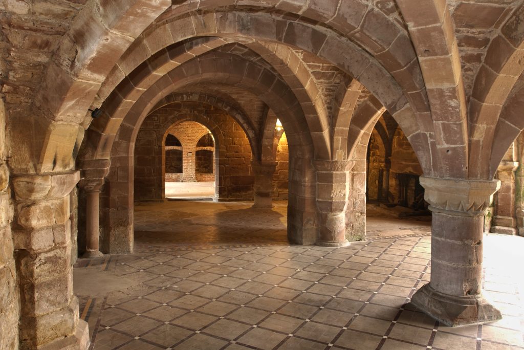
Archaeological interest in monastic sites developed during the 19th century, with a particular focus on Cistercian sites. There were excavations at Sawley (Fig 5.14) in the early 1850s and again in the 1870s (Walbran 1852-3; 1876), at Shap in 1889 (Weston & Hope 1889), and at Furness at the end of the century following earlier clearance from the 1840s (Hope 1900; Brakspear 1901; Harrison et al 1998). Limited excavations were carried out at Holme Cultrum soon after, (Hodgson 1907) and also at Whalley in the 1930s, following earlier clearance from the 1790s. These early excavations tended to focus upon the church and the immediate buildings of the cloister, as did excavations on the houses of other orders such as Burscough (Bromley 1890), Cockersand (Swarbrick 1923) and Conishead (Kelly 1930). Modern research excavations have been carried out on a number of monastic sites. Norton stands out as the most extensively excavated monastic site under modern conditions in the country (Greene 1989; Fig 5.15). The post-excavation programme is still in progress.
Medium- to large-scale, modern excavations have been carried out at Chester Abbey and Chester Dominicans (Ward 1990; Ward 2000a), of which the latter is published. Excavations in the past have also been conducted at Vale Royal (LUAU 1997a; 1998a; 1998b; McNeil & Turner 1990; Thompson 1962) and Chester Nunnery, both of which are published. There have been small-scale excavations at Furness Abbey including important work in the southern half of the precinct (Wood 1999), at various locations in and around Whalley Abbey (LUAU 1991a; 1991b; Lloyd Evans Prichard 2002), in the south cloister range at Sawley, 1977-84 (Coppack et al, 2002) and the monastic precinct at St Bees.
Recording of standing remains using modern techniques has only been carried out extensively at a few sites. The Furness Abbey Survey Project, undertaken by LUAU, was one of a number of historic fabric surveys initiated by English Heritage in the 1980s. At the time Furness was the largest and most complex site for which complete survey had been attempted. The results await full publication (see Wood 1992 and forthcoming; Keevill Heritage Consultancy 2004; PLB Consulting Ltd & Associates 2004). Historic fabric surveys have also been conducted at Whalley Abbey (L) (LUAU 1991a; 1997b; Lloyd Evans Prichard 2002), Chester Abbey (Ward 1998; Ward 2000b), Vale Royal Abbey, Birkenhead Priory (Davey & Lewis 1991; Lewis 1992a; 1992b) and Lanercost (Summerson & Harrison 2000). Targeted recording was also undertaken at Calder Abbey during consolidation works in 1995-96 (J Quartermaine pers comm). A range of developer-funded small excavations and watching briefs have seldom achieved more than a passing mention, although there are exceptions at Lanercost and Cartmel (eg Whitworth 1998, Wild & Howard-Davis 2000).
Although there has been extensive research into documentary records of monastic sites of all kinds, and their estates over the past 150 years, archaeological excavation and recording has concentrated almost entirely on the remains of the claustral buildings of the larger monasteries. The exception is excavation at the tiny Gilbertine house of Ravenstonedale carried out in 1928-9 (Frankland 1929, 1930; Turnbull & Walsh 1992). Apart from the published excavations at Warrington Austins (Heawood et al 2003) and Chester Grey Friars (Ward 2000a), little work has been carried out on the lesser monastic sites such as friaries, nunneries or hospitals; nor has there been extensive field investigation of the archaeology of monastic granges and estates in the region. Limited excavation at the Hospital of St Saviour, Stydd in the 1960s (Edwards 1977b) has been interpreted as the remains as a Mithraeum.
Overall the region has made small contribution to the national research agenda for understanding the social and economic impact of Medieval religious houses and the post-Dissolution histories of their estates. Considering that religious houses and their estates represent some of the most substantially surviving archaeological sites and buildings of the period, there has been relatively little new research in the last 50 years beyond the work at Norton and Furness which both remain largely unpublished.
The distribution of Medieval churches and chapels across the North West was relatively sparse, reflecting the largely dispersed and small population, and was dominated by monastic estates such as Furness Abbey, Whalley Abbey and St Mary’s Priory, Lancaster. Even so, churches and chapels are among the most common surviving Medieval buildings. In Lancashire, their physical development has been analysed in detail by the Victoria County History, but in the North West in general, there has been little archaeological investigation of churches and chapels, either of their standing fabric, or on below-ground remains. A small number of watching briefs have been linked to re-ordering and landscaping works, for example at St Mary’s Priory, Lancaster, and at St Bartholomew’s Church, Wilmslow where a section was recorded through the churchyard wall and a number of Medieval architectural fragments were recovered. Overall, however, there has been no analysis of the distribution of Medieval places of worship nor their relation to earlier estate and parish centres. Medieval Lancashire had 52 parish churches and 92 chapels, of which 29 churches and three chapels may have had pre-Conquest origins. Only four, however, have any known pre-Norman masonry, and only another ten are known to have Norman fabric. Early English work from the 13th century is almost as rare (Fig 5.16). Most surviving churches appear to date from the 14th century or later, and many seem to have been substantially rebuilt in the 16th century, often followed by extensive remodelling in the 19th century (Nevell & Hradil 2005a, 13-27). In some cases, alterations may mask earlier fabric. At Poulton-le-Fylde, for example, recent restoration work has shown that a documented rebuilding in the 16th century was in fact a refacing of the original fabric. Beneath ashlared stonework, the original Norman masonry and fenestration survived intact (Storey 2001, 37).
Most churches and chapels were stone-built, reflecting the importance of these buildings to their local communities (Nevell & Hradil 2005b). There were, however, a number of timber-framed churches in the region, representing 10 of the 27 timber-framed chapels and parish churches which survive in England, although few survive complete. Those in the townships of Baddiley, Holmes Chapel, Lower Peover, Marton, Siddington, Swettenham, and Whitegate lie in modern Cheshire. The churches and chapels in Chadkirk, Denton and Warburton now lie in Greater Manchester and have been recently studied by the University of Manchester Archaeological Unit. The parish churches at Marton and Lower Peover, both 14th century, are considered the oldest longitudinal aisled churches in Europe, and Warburton church is probably of the same date (UMAU 1999a). The latest to be built, St Lawrence’s in Denton, is mid-16th century (Nevell & Hradil 2005b). In plan these churches fall into two groups; aisled structures (Holmes Chapel, Marton, Peover, Warburton, Whitegate) and linear, single bay structures (the rest). Most began as chapels and it seems likely that their status as subsidiary religious sites may have led indirectly to their survival through the absence of a wealthy patron prepared to rebuild the chapel in stone or brick.
Considering their importance as the richest surviving resource for studying Medieval communities, their places of worship and burial, there has been remarkably little recent research into or archaeological investigation of Medieval churches and their context in villages and towns. The repair, renovation and development of Medieval church and chapels appear seldom to have been the subject of archaeological evaluation or recording.
The scarcity of churches may have been supplemented by preaching crosses, though the nature or purpose of many standing stone crosses is uncertain. Survival is best in churchyards, but there are also Medieval crosses sited in moorland and open country. Crosses also marked the boundary of monastic estates, such as the well-preserved group of cross bases connected to Vale Royal Abbey (Ch). Wayside crosses were often placed along Roman roads, such as those on the line between Wigan and Standish, and perhaps confirm the continuity of use of those routes. There were also market crosses in many of the boroughs and market villages, some very elaborate. These do not survive so well, as they were often moved or have disappeared from an inconvenient location with the advent of trams and the motor car, and others were rebuilt to commemorate occasions such as Queen Victoria’s jubilees. The market cross in Ormskirk (L), for example, was replaced by a fine clock tower in the late 19th century.
There are just over 200 known bloomeries in Cumbria (Fig 5.17), though there are some problems with duplication and misidentification, and upstanding earthwork sites are still being identified. Recent work on the Cumbrian bloomeries, however, has produced several radiocarbon dates spanning the Medieval period, from the 12th century onwards (J Hodgson pers comm). The Greater Manchester SMR lists eight sites from above- or below-ground field evidence and further sites are known solely from documentary references (N Redhead pers comm). Remaining counties contain few known sites, though a 15th century water-powered bloomery has recently been identified at Little Moreton Hall (Ch). Iron mining has received very little archaeological attention, either regionally or nationally; the MPP Step 3 assessments (Instone 1995) remain the only national survey, while the Furness Iron survey (Bowden 2000) includes professional surveys of sites in Furness and Eskdale; however none of the sites in either coverage include demonstrable Medieval features, and field evidence for historically-documented Medieval mining in Furness has yet to be definitely located.

No iron mining or other extraction has yet been located on the coalfields of the region. As regards smelting, the Lake District iron industry has had a strong tradition of research from the late 19th century onwards (eg Collingwood 1902, Fell 1908, Parker & Fair 1922, 1925, Bowden 2000). Research and site identification by Davies-Shiel continues in Cumbria, and the Lake District National Park and National Trust are undertaking a programme of assessment survey and targeted geophysical survey and radiocarbon dating (Cranstone & Irwin forthcoming). Elsewhere bloomeries have received little attention, apart from the work of Norman Redhead (1995; 2003-4) in Greater Manchester. The recorded distribution of sites is probably skewed by biases in both research and site survival, and may particularly under-represent sites on the now heavily urbanised and industrialised coalfields and areas of agricultural improvement. Research in Cumbria has concentrated almost entirely on non-invasive fieldwork, whereas work in Greater Manchester has centred on excavation.
The radiocarbon dates from the current Lake District research project range from the 12th to the 16th centuries AD, but have not yet been systematically related to site type. The Castleshaw (GM) site is also dated to 12th to 14th centuries. Recent excavations at Whitecarr Lane (GM) and Gadbury Fold (GM) have given late Medieval dates for bloomery-related deposits, on ceramic evidence. The geophysical element of the Lake District project has shown that with high-resolution magnetometry and filled-colour contour plotting, in situ bloomery furnace bases produce a very clear orientated-dipole signature; the potential for non-invasive archaeomagnetic dating from the orientation of the dipole is currently being investigated. The field survey element of the project has indicated a very marked size range, from under 10m3 to over 1000m3 for seemingly-undisturbed sites. The relationships of site type to Medieval tenurial arrangements, including monastic estates, are under investigation. Water-powered bloomeries remain very much under-identified and under-studied, both regionally and nationally. The Lake District project has surveyed and dated two sites at Belham Tarn (cal AD 1420-1440) and Black Moss Pot (cal AD 1430-1650) and at least two further sites have been identified as either Medieval or post-Medieval. The Little Moreton Hall (Ch) site is of late 15th century date and, unlike the currently-identified Lake District sites, is on a secular magnate’s estate rather than a Cistercian monastic estate.
Finally, recent research on the continent (Magnusson 1995), indicates that the blast furnace was present in central Sweden by the mid-12th century, and was widespread in parts of Sweden by the following century; 13th century furnaces are also now known from Germany and Switzerland. These early furnaces appear to be consistently sited in relation to oxide/low phosphorus ores. This evidence challenges the conventional assumption that the blast furnace was first introduced into Britain in the Weald (a carbonate/high phosphorus orefield) at the end of the 15th century, and only later spread to northern England. The possibility of Medieval blast furnaces of Nordic inspiration must now be seriously considered, especially in the Lake District.
The region’s main lead orefields are the North Pennines and Lake District, with localised lead mineralisation elsewhere. The major lead orefields of Flintshire, Derbyshire, and the Yorkshire Dales are just outside the region, but associated smelting and lead/silver processing may fall within the boundaries. Many of the lead ores are argentiferous, and may have been important silver producers in the earlier Middle Ages (Blanchard 1992). There is documentary evidence for exploitation of the Alston Moor mines from the 12th century, and Fletcheras mine near Garrigill is specifically mentioned in the 15th century (Raistrick & Jennings 1983, 46-50). Field evidence for 11th to 12th century mining at Browngill, also near Garrigill, appears to have been found in the 19th century (Raistrick & Jennings 1983, 46-7). The 12th century mining on Alston Moor may have been on a massive scale, with mining and water-management features. The main Medieval lead smelting process was the bole/bale, followed by washing and resmelting of the slags in a blackwork oven (Willies & Cranstone 1992, Kiernan 1989). More sophisticated furnace lead-smelting processes may have been in use, especially at Crown mines.
Medieval lead-mining has received virtually no archaeological study within the region, and substantial field evidence is likely to survive within the multi-period mining landscapes of the North Pennines. Medieval evidence may be more easily identifiable at outlying sites such as Ashknotts, where later activity has been less extensive. The same applies to smelting; there is evidence for Medieval lead smelting at several sites in Cumbria, and at Alderley Edge in Cheshire. There was probably lead smelting at Smelfthwaites, near the lead mines at Ashnott (L) where there are the remains of a stone-lined drain for mine drainage (M C Higham 1989a). Medieval lead extraction appears to have been short lived in Bowland (L), and did not recommence until the 16th century.
The main copper orefield of the region is the Lake District, notably the Keswick, Caldbeck, and Coniston areas. There is also an important source at Alderley Edge which was worked in the Bronze Age, Roman and post-Medieval periods. Medieval copper mining in England is very poorly known, either from documentary or field evidence. A consequent assumption in the literature that copper was not exploited between the Roman period and the 16th century requires challenging. There is documentary evidence for 15th century Crown mining in the Keswick area, including the introduction of German experts, but field evidence has not yet been located; Shaw (1983, 7-8) suggests Goldscope as the location. The technology of Medieval copper smelting appears to be unknown, though water-powered shaft furnaces may have been used.
The main coalfields are in west Cumbria and Lancashire, the latter extending through Greater Manchester into north-east Cheshire. Small-scale outcrops also occur, both in small outliers and as sporadic seams in earlier Carboniferous deposits. On the Cumberland coalfield, St Bees Abbey obtained rights to extract coal in the Whitehaven area in the 13th century.

By the 15th century, mining is also documented at Great Broughton, Dean, and near Loweswater, and at Tindale near Brampton in east Cumbria (Hatcher 1993, 111-113).
In Lancashire the first documented major colliery was at Haigh in the early 16th century (Hatcher 1993, 117-120), and other references to coal mining appear to have been small-scale. The only known archaeological investigation within the region is at Gadbury Fold near Wigan, where recent excavations showed extensive 13th to 14th century mining (Redhead 2003-4). Nationally, a very high potential has been shown for coal mining features, artefacts, and mining technology (Hartley 1994), and the study of small-scale coal workings is as important as large-scale mining.
Whilst stone was used throughout the region for prestige buildings, its use for lesser domestic buildings varied. The archaeology of Medieval quarrying has, however, received little attention nationally, and virtually none regionally. The MPP Step 3 assessments list only one site in the region, at Stainton in Cumbria (LUAU 1999b, Appendix 3). This may have provided the limestone for certain architectural details at Furness Abbey (Fig 5.18). The remainder of the Abbey is of St Bees Sandstone extracted from a number of quarry sites adjacent to a site surveyed by the RCHME (Wood 1999). The limited literature is biased towards high-quality freestone quarries, rather than towards the sources for more vernacular structures, or the technology of quarrying. Clifton-Taylor implies late-Medieval roofing stone extraction from Mow Cop (Ch), and freestone from Wetheral (C), St Bees Head (C) and Penrith (1972, 415-430). The quarrying of freestone, rubblestone, roofing stone, slate, and millstones differ in technology, and archaeological evidence for all is likely to occur within the region.
The earliest documentary evidence for saltworking in the North West is provided by the Domesday survey for Cheshire, when the centres of salt production were firmly established in the three ‘wich’ towns of Middlewich, Nantwich and Northwich. At these inland works, brine was usually drawn from natural brine springs, where brine pits were developed, and later, shafts or wells were dug by hand to the wet rock head. Brine was raised and stored in brine cisterns or brine tanks where any solid material was allowed to settle before the brine was allowed to flow through brine pipes by gravity into the evaporating pans. Small lead pans were used throughout the Medieval period, but began to be replaced by larger pans of riveted iron sheets later in the period. Excavations in Nantwich in 1979-80 revealed timber-framed workshops containing cisterns for storing brine, and two adjoining late 12th century salthouses. The salthouses were of differing construction: one was built with stake and wattle walls, the other built around massive squared earth-fast posts, although they were of similar size and appear to have been built as standardised units (McNeil 1983, 61). Recent excavations have revealed other well-preserved timber buildings associated with salt making (Cheshire County Council 2004; Fig 5.19).

Salt production in Cheshire followed a technology that was in the main already well established, using timber-lined brine pits, positioned in valley-floor locations in simple open-ended, barn-like structures, known as ‘wich houses’. Little work has been undertaken on coastal salt production in the North West. This is likely to have been carried out in the vicinity of the flat estuarine intertidal areas of the Dee, Ribble, Morecambe Bay and the Solway, where some Medieval salterns are already known. There are references to salt-making around the Solway and Morecambe Bay, and in west Cumberland, largely associated with monastic houses, notably Holme Cultram Abbey, where peat was used as fuel (Martin 1975). Production was likely to have been through the process known as sleeching or sand-washing, where salt-impregnated sands and silts were filtered through a bed of turf or peat, and the resulting brine was boiled in small pans. The waste sand from the process often remains in large distinctive mounds. On rocky coasts, seawater may have been directly boiled, without prior concentration, using large cast-iron pans fuelled with coal (Wilkinson et al 1998). The direct boiling process developed from sleeching in the later Medieval period, and it has been suggested that salt was possibly produced by direct boiling in the 13th century at Saltom on the West Cumberland coalfield (Walsh 1991, 39). The most recent publicly-available overview is contained in the MPP Step 1 Report (Barford et al 1998), revised and supplemented by the Step 1 Consultation Report and the Step 2 Shortlist of Sites (Cranstone 1999a; 1999b).
Archaeological evidence for manufacturing in the North West is sparse, even in the urban centres. The evidence from Chester consists mainly of waste products and tools unrelated to any in situ structural remains, although timber-lined pits associated with tanning have been recorded east of the city walls at Love Street (Newstead 1934) and at the Bars (UMAU 1998). A small number of hide off-cuts and cobblers’ waste were found in the city ditch in 1991, suggesting both shoe-making and mending. Excavations at Witter Place produced evidence for copper alloy metalworking in the form of clay moulds for cauldrons and other vessels. Several fragments from a single cauldron mould were found at Crook Street in 1963, another fragment was also found at Hunter Street, and part of a stone composite mould for annular brooches was found at the Northgate Brewery site (Davey 1973). Outside of Chester, information on the manufacture of metal products is restricted to evidence of bell-casting at Norton Priory. Fragments of molten glass have been found in Handbridge and are considered to be evidence of working on or close to the site, although the date is unclear. Glass working, possibly for glazing, is indicated in Delamere Forest by a dump of crucibles and broken glass, probably for use as cullet (recycled material). Molten waste was also found but no furnace has definitely been identified. Field name evidence suggests glass working or making at Mobberley and Rushton but no archaeological evidence has been located. A large pair of wooden and leather bellows recovered from a 14th century context within Carlisle city ditch were probably industrial in function (OA North 2002e).
Elsewhere in the North West, very little archaeological work has been carried out on manufacturing sites. There is plentiful documentary evidence for the presence of corn and fulling mills, for example, but none have been excavated and very few have even had limited survey. At Harraby, Carlisle, however, Medieval deposits were discovered at a 19th century corn mill where a Medieval one was known (NPH 2003c). There is some excavated evidence of corn-drying, for example at Audlem (Ch) (Cheshire County Council 2001), in Chester (Ward 1998), and Mitchell’s Brewery, Lancaster (Huckerby forthcoming).
This lack of evidence is largely because many mills continued in use and were redeveloped in the post-Medieval period. Some fulling mills were abandoned, however, such as at Slaidburn (L), where initial survey has identified a surviving leat and potash pits (M C Higham 1998). Surveys in Cumbria have identified the remains of potash kilns, fulling mill sites and tenter banks (Davies-Shiel 1972; 1974), whilst other work in both Lancashire and Cumbria has identified physical evidence for flax and hemp retting (M C Higham 1989b).
The physical evidence for Medieval textile production is very scant. Spindle whorls have been found at a variety of sites and the remains of a glass linen smoother/calendar were found in Chester. There is documentary evidence for manorially controlled fulling mills across the North West, but none has been excavated. Many later evolved into cotton textile mills, particularly in Lancashire. Recent investigations at Alderley Edge produced iron slag, including tap slag and hammer scale, from a buried soil found during excavation of a trench across the township boundary, and the recent excavation of the salthouses at Wood Street, Nantwich also produced evidence suggesting metal and leather-working.
The evidence for pottery and tile production (Fig 5.20) in the North West is extremely poor. In Chester, two tile kilns were excavated at the Deanery field and a dump of Medieval roof tiles, including many wasters or ‘seconds’ was found at George Street (Rutter 1977). A short distance away to the east of the city walls a dump of waste pottery and building material was found in Frodsham Street (Rutter 1990). Seven or eight other production sites have been identified by finds of waste pottery, but only four Medieval kilns have been excavated, all in Cheshire, and the region was also served by kilns beyond its present borders. A floor tile kiln was also discovered and excavated at Norton Priory. Part of the North West region was also included in a study of Medieval floor tiles in northern England (Stopford 2005), examining changes in the design, production and use of floor tiles between the early 13th century and the Dissolution of the monasteries.

Two of the Cheshire kilns were excavated in 1933 and 1948, (Newstead & Droop 1934, Webster & Dunning 1960), and a third was found during excavation of a Roman villa at Eaton-by-Tarporley in 1982. At Brereton Park (Ch) one kiln was partially excavated (Rutter 1983), and three others are thought to lie close by, and a group of wasted pottery was found during recent excavations on a pipeline. A kiln, excavated within the Medieval city walls of Chester in 1936 (Newstead & Droop 1936), is probably a tile kiln, but the evidence is unclear and very little waster material was found. The possible remains of a fifth kiln were found in 2002 along with large quantities of pottery, including numerous wasters, during pipeline construction at Samlesbury near Preston. No actual structure was found but a burnt area may represent the position of a kiln. The pottery has highlighted potential differences in Medieval pottery traditions north and south of the River Ribble. The only other evidence for pottery production is in the form of finds of waste material and documentary evidence.
Excavations in Prescot (Holgate 1989) produced 74 fragments of wasters, and a dump of waste pottery and building material was found in Chester in the late 1970s just outside the city walls (Rutter 1990). In Cumbria waste pottery has been found at Waberthwaite (Cherry & Cherry 1984b) and also from several sites in Carlisle, most recently from Botchergate (I Miller pers comm). Pottery and kiln debris have been found in Lancashire, in 1992 at Ellel, to the south of Lancaster (White 1993), and recently at Caton which is also known from documentary evidence (OA North 2003d). Pottery industries are well known at Docker Moor and Silverdale on the Lancashire/Cumbria border where production at the former began in the late 12th to early 13th century, and in the late Medieval period at the latter (Edwards 1967; Miller & White forthcoming). Evidence has been gained from documents, earthwork evidence, finds of wasters and a resistivity survey (White 2000a).
Parallels between waste pottery and some excavated material (Fig 5.21) can be identified in the relevant areas but further evidence is required to identify distribution zones. Well-stratified occupation deposits and independent dating means are required to identify the time spans during which these sites were in production. Little is known about technological advances or changes in ceramic production in the North West. Whilst some changes can be detected in methods of manufacture there is not enough evidence to associate these with any chronological or geographical framework.

Chester was the premier port in the North West during the Medieval period (Carrington 1996). A wide range of objects entered the city both by the port and over land, although the archaeological evidence for these external contacts is relatively rare. Many of the goods were either perishable or raw materials which were converted to or used to produce other objects and materials. The principal archaeological evidence for trade thus consists of ceramics, stone and glass. There is considerable potential, however, in the reclaimed ground outside the Watergate and along the western defences. Important evidence for ships and shipbuilding may also be buried in the river silts and river bed but the potential has only very recently begun to be assessed (Gifford & Partners 2002b). There are three recorded shipwrecks in the River Dee, all lost in 1536, and carrying cargoes of wine and wood. The evidence for the ships is documentary, and their exact locations have not been identified (NMR unique identifiers 1324874; 1324880; 1324885). Only one other shipwreck is recorded for the North West, a 15th to 16th century sailing vessel off Barrow-in-Furness, identified in 1839 when timbers and cannons were found (NMR unique identifier 908215). Other ports and creeks operated along the length of the North West coastline in the Medieval period, though little, if any, archaeological work has been carried out.
Knowledge of Medieval pottery up to the mid-13th century is limited in the North West. A sequence of fabrics and forms has been suggested by associated dendrochronology for the 12th and early 13th centuries in Carlisle, and similar wares have been recognised from excavations at Dacre (C), Penrith and elsewhere, enabling a distribution pattern to be suggested for the principal wares of the period. In Nantwich two wich houses produced good groups of late 12th century pottery, but production sources are yet to be discovered, and there is a mid- to late-12th century assemblage from Norton Priory. Elsewhere in the region, published evidence is not available. There is a relative abundance of pottery in the North West from the mid-13th to the 14th centuries, but as with the earlier pottery, there is a bias towards pottery from Cheshire and Cumbria. The pottery sequence for Carlisle is published and further work is in progress (McCarthy & Brooks 1992). There are other Medieval sequences at the Medieval towns of Cockermouth (C) and Kendal, whilst excavations at Dacre recovered over 2000 sherds forming a sequence from the 13th or 14th century. Only small quantities have been recovered elsewhere in Cumbria, for example Penrith and Cartmel Priory (Newman et al 2000; Wild & Howard-Davis 2000). Chester also has good sequences of pottery for this period, and has utilised dated assemblages from castles in North Wales to date some local wares. Little is understood about the extent of use in comparison with other materials, nor about the change from using wares made from Cheshire boulder clays to those made from Coal Measure clays. This seems to have occurred sometime in the 14th century. Outside of Chester district, there is a poorly stratified assemblage from Beeston Castle, and unpublished assemblages from Middlewich and Nantwich. Pottery from towns in the east of the county, such as Macclesfield and Congleton, is poorly understood, and there is little material from the few excavations of rural settlements, although a moated site near Audlem produced a relatively large Medieval assemblage. Excavations at the religious sites of Norton Priory and Warrington Friary, however, have produced substantial assemblages, as yet awaiting full publication.
Pottery of mid-13th to 14th century date from Lancashire and Merseyside is less well-represented, and many of the assemblages have been small and poorly stratified, a situation commented on in 1975 (Hurst 1977, 123). In Lancashire few towns have been the subject of archaeological excavation and no significant groups of pottery have been published (White 1996, 123, 137). In Merseyside, there is pottery from West Derby Castle and Prescot (Holgate 1989), including wasters, and small quantities of pottery have been found through field walking and excavation. More recent excavations have begun to produce pottery, however, such as the largest group yet excavated in Lancaster from Mitchell’s Brewery in the 1990s, and from Fishergate, Preston in 1989 (White 1996, 132, 135). An unusually large spread of Medieval pottery on the outskirts of Inskip in North Lancashire was a rare discovery in a rural settlement, made during the North West Wetlands Survey (Middleton et al 1995, 116). The sherds were small and abraded but some diagnostic features survive to suggest that they were made at Ellel (L).
Excavations in 1994 and 1995 produced the first sizeable stratified assemblages from the Merseyside area. The first, at Fazakerley (Wright 1996), the site of a toft close to known 14th-century settlement, is one of the few rural sites to have been excavated. Unfortunately, features which could be dated by radiocarbon analysis could not be related in any meaningful way to the pottery assemblages. The second, a site at Eccleston Hall, near St Helens, where the earliest documented reference is c 1374 (Philpott & Irvine 1991, 10), produced small but key groups for the late Medieval/transitional period, which it may be possible to put into a chronological sequence. Parallels can be found amongst these assemblages with late Medieval pottery found in other small but key groups in Merseyside from the Old Hutt (Wrathmell 1992) and Speke Hall (Higgins 1992). Despite the lack of absolute dating, some of the pottery from Fazakerley and Eccleston, along with the material from sites at Tarbock, Roby and Newton-le-Willows, does share some characteristics of form and fabric with the Prescot material and with each other that would seem to indicate a common and therefore perhaps local production. The date of this production is unclear, the later 14th or 15th century has been suggested as the most likely (Davey 1991, 127) but the possibilities for an earlier date have been discussed recently (Speakman 2000). Although these ‘local’ wares cannot be securely dated or provenanced it is clear that they are quite different in character to the bulk of pottery found in Chester and have more affinity with the northern gritty ware traditions (Davey 1991, 124-7).
A similar situation exists in Greater Manchester where there is also no sequence of fabrics or forms for the city or the area as a whole although a number of sites have produced pottery since 1975, when Bury Castle was the only representative. Most of the assemblages that have been published are small and fragmentary. Recently, during excavations in Manchester city centre, a small group of probable later Medieval pottery was found associated with a large quantity of leather artefacts in the Hanging Ditch, a Medieval watercourse backfilled by the mid-16th century. Excavations at Wigan in 1984 produced the first archaeological evidence for the Medieval town: a timber-lined well which contained a group of possible late 13th– to early 14th-century pottery (Jones & Price 1985). Further work took place in 1990 at Hallgate, Wigan, when the excavation of Medieval burgage plots also produced a good group of Medieval pottery some of which have been suggested to be wasters (Clark 1991). Long running excavations by the South Trafford Archaeology Group at Timperley Old Hall, a moated site near Altrincham, have produced groups of 13th to 16th century pottery which are currently being studied (Faulkner 1994, 16). A small 15th to 16th century assemblage has also recently been found at another moated site at Denton to the south of Manchester. As with the Merseyside material the pottery reported on from Greater Manchester is of a type comparable with the gritty ware traditions to the north-east of the area. This is particularly clear in the Hallgate, Wigan, group where parallels have been made with some of the Prescot pottery (Clark 1991, 12). As on Merseyside, however, the small quantities of material, poor stratification and an absence of any long occupation sequences containing pottery mean that it is currently difficult to develop a ceramic sequence.
Whilst the sources of much of the region’s pottery are poorly understood it is difficult to draw detailed conclusions regarding exchange and interaction based on pottery distribution. Broad patterns of distribution can be identified, some of which appear to follow natural boundaries such as the Mersey. Some of these extend beyond the boundaries of the region, for example Chester with North Wales and possibly the West Midlands, Cumbria with the North East and Scotland and possible links between Greater Manchester and the east of England. Whilst the evidence for pottery distribution across the region is patchy the existing evidence suggests a lack of interchange of locally produced wares across the region as a whole. The region can be divided into several zones within which certain types of pottery appear to circulate. Cheshire is dominated by red-firing wares during the 13th and 14th centuries but sometime in the 14th century pink/white-firing wares become common. These wares are occasionally found north of the Mersey but only in small numbers as a different tradition seems to have developed there. In the Merseyside area and extending over to Greater Manchester, hard, quite coarse sandy wares appear to be dominant. In Lancashire there are still too few assemblages to be able to form any preliminary thoughts on distribution but the types of wares found at Ellel are similar to the coarse sandy wares found on Merseyside. In Cumbria four possible regions of ceramic tradition have been suggested to exist for the 12th and 13th centuries (McCarthy & Brooks 1992, 34). One includes Carlisle, Penrith and Dacre and follows the Eden Valley; two others are indicated by different groups of material at Kendal and Cockermouth; a fourth area in southern Cumbria has no excavated assemblages but might be ceramically related to northern Lancashire. The trends for the later periods in Cumbria are not clear although more homogeneity is suggested (McCarthy & Brooks 1992, 36) and also a continuation of influences from north-eastern England and Scotland rather than from the south of the region (Miller forthcoming). The extent and use of imported pottery is unclear. A variety of wares have been found in Chester; including Dublin coarsewares, developed Stamford wares, Scarborough, Saintonge, Ham Green and Tudor Green types. Saintonge wares, Surrey wares (Cheam) and Humber wares have also been identified north of the Mersey. Further work is required to examine the long distance trading patterns, their variation and the reasons for this across the region.
Meols is a remarkable site at the northern tip of the Wirral peninsula which produced an extremely large and varied assemblage of everyday Medieval items, mainly metalwork, as erosion by the sea advanced during the 19th century (Fig 5.22). The evidence suggests that Medieval activity was a continuation of an earlier, pre-Conquest settlement. The antiquarian collections from the site, now in several different museums, together comprise a collection second in range and scope only to that from London for the later Medieval period. The finds continue to the late 15th to early 16th century, when the settlement presumably declined irreversibly. There are thousands of dress accessories, buckles, brooches, mounts etc, including some casting wasters of lead/tin from the 15th to early 16th centuries and series of copper-alloy mounts which may never have been used. A small group of late Norman copper alloy brooches also appear to include wasters from cold hammering. Overall, the fashions are those familiar from large urban excavations across the country. The assemblage includes cheap political badges from the Wars of the Roses or a little later, and a wide range of pilgrim souvenir badges (Fig 5.23), not only ones from English shrines, but also from Germany, southern France and Rome. Domestic equipment, though sparser, is also typical of that found in towns, such as knives, pewter spoons and metal kitchen wares. In contrast, there are a few buckles that have been very clumsily repaired and some keys made of copper alloy sheeting are the kinds of substitutes that might be devised by a community which had temporarily lost direct access to a mainstream market and to some routine metalworking techniques. Fish hooks indicate the likely economic basis of the settlement. Occasional high-class items, like a door or chest ring and part of a Romanesque candlestick of a form found in major churches on the Continent, add to the unusual profile of the finds from Meols. Altogether, the assemblage indicates that the site was far more than a fishing village in the Medieval period. It appears to have acted as a major entry point for goods coming into the North West, and developed as a manufacturing centre of metal goods to cater for that trade. Given the general paucity of artefacts from most excavated sites across the North West, Meols stands in stark contrast.


Archaeological work on the castles of the north has been sporadic. There are numerous guidebooks and gazetteers to the castles, and notable surveys (Curwen 1913; RCHME 1936; Hugill 1970 and 1977; King 1983; Stretton 1994; Perriam & Robinson 1998) although within these works the archaeological evidence has been recorded and interpreted to varying degrees.
The earliest castles in the region were of earth and timber construction generally of motte and bailey form. In the Greater Manchester area, many were short-lived, such as Watch Hill, one of three castles guarding the eastern side of the Bollin valley (Redhead 1997, 34-5), and others have been obscured by later development. The motte at Dunham Massey is now truncated as a garden feature and that at Ullerswood is topped by a house and obscured by trees. At Castleton, Rochdale, the truncated motte sits beneath an early 19th century house, and the bailey has been built over (Fishwick 1889, Battersby 2001). Cumbria’s mottes for the most part are likely to be later than those further south in the region as the full impact of Norman settlement was not felt until later in the 12th century. The influence of a fluctuating frontier with Scotland appears likely to have at least in part dictated the distribution of these earth and timber castles in the north of the region. There are comparatively few in Lancashire, but a distinct group concentrated in the Lune valley possibly related to a late 11th century border with Scotland (M C Higham 1991, 85; Wood 1996). These include the well preserved and largely unexplored sites at Halton and Hornby (Castlestede) near Lancaster, and the early 12th-century castle which preceded the later masonry castle at Lancaster itself. A further less clearly defined line of mottes along the Ribble valley may also relate to a frontier, perhaps that temporarily formed during the anarchy of Stephen’s reign when Scottish power extended southwards. In Cumbria, the concentration of mottes is close to the Scottish border, though whether they truly represent national defensive lines, or reflect the militaristic feudal nature and status of the 12th century landholdings (Lott 1995) is arguable. In some cases similar castles appear to oppose each other across the border as at Liddel Castle and Liddel Strength (MacIvor 2001, 25). Many of these early castles fulfilled functions both as baronial strongholds and estate administrative centres, and as strategic military installations (Wood 1996, 145). Overall modern archaeological investigation to substantiate speculation about dating, fluctuating frontiers and the functions of these earthwork sites is generally lacking.
Few ringworks are known from the region, possibly because they are often obscured by later developments. The stone castle at Kendal is considered to have originated as a 12th century ringwork for example, and the motte at Aldingham (C) originated as a ringwork (Davison 1969). The three known in Greater Manchester are Buckton Castle (Nevell 1991, 115-7), Manchester and Stockport. Manchester was replaced by a manor house in the 13th century (Morris 1983, 36-7), and the site is now occupied by Chethams College, and Stockport castle walls were levelled in the late 18th century for the construction of a cotton mill (Arrowsmith 1997, 31-4). In south-west Lancashire and Merseyside, West Derby Castle, Mote Hill in Warrington, and possibly Burnardescastle in Lathom may also have originated as ringworks (Lewis 2000, 89-91).
In Cheshire any relationship between the Anglo-Welsh border and early castles is more difficult to establish. Although motte and bailey castles are more numerous in the Welsh Marches (Renn 1973), there are only 13 definite mottes in Cheshire and one in Merseyside. In western Cheshire, along the border with Wales there are motte and bailey castles located at Dodleston, Aldford, Pulford and Malpas, plus Castletown at Church Shocklach, which forms part of more complex earthworks. Chester and Shotwick (Fig 5.24) to the north can also be considered as part of the group although they continued in existence as royal castles and so are much modified. Traditionally these castles have been considered to belong to the immediate post-conquest period, the result of the imposition of Norman control in an unsettled, frontier area. Earthwork surveys, resistivity surveys, and small-scale research excavation at Aldford, make it the most intensively investigated of the group (Cocroft 1996; Lowerre et al 2003). The excavations at Aldford, however, produced no evidence for occupation significantly earlier than the early-13th century. This raises the interesting possibility that these castles may not have been built in the immediate post-conquest period, but instead, in the late-12th century, during a period when the Welsh princes were ascendant. Other castles such as Castle Cob are seen as protecting and controlling the agricultural resources of the Cheshire Plain.

Chester Castle had a major administrative and symbolic function, though it was not particularly important or innovative from a military architectural point of view (Donald Insall Associates Ltd 2001). The original castle was a motte and bailey. During the 12th and early 13th centuries, it was rebuilt in stone as a curtain wall castle and a large new outer bailey was added. The motte was retained but lost its military predominance. Improvements continued under the Crown through the 14th century. Substantial accommodation for the constables and the Royal family were also constructed. Substantial rebuilding in the 18th to the 20th centuries probably destroyed the greater part of the Medieval domestic ranges. However, the outer bailey wall and gates appear to survive beneath the present parade ground. Excavations, evaluations and watching briefs have demonstrated a good, below ground survival of the archaeological resource in those areas unaffected by post-Medieval destruction (Ellis et al 1996; Ward 1993). The upstanding masonry structures are also a valuable research resource but are in danger from lack of repair. The site has considerable research potential in the areas of military architecture with the development from earthwork to masonry structures and for high-status finds particularly the in-filled ditches which have good potential for survival of organic remains.
Large-scale, modern archaeological investigations of earth and timber castles have concentrated on those that developed into important later castles as at Halton and Nantwich in Cheshire. There have been a few modern archaeological explorations, including Davison’s excavations at Aldingham, and a number of excavations in the Manchester area, including at Watch Hill in 1976 (Brown & Johnson 1985, 35-8), and at Chethams Yard, exposing a possible inner defensive ditch for the Manchester ringwork (Tindall 1983, 5-8). Although a number were at least partially excavated in the 19th century, for example Penwortham, near Preston, and Mote Hill, Warrington, these have not been especially informative (Renn 1973) and often the detailed information from the investigations has been lost as at Hornby in the Lune valley. Little archaeological work of any type has been undertaken on Cumbria’s northern earth and timber castles. Of the larger castles in the north of the region, there have been few formal or extensive historic fabric surveys or excavations with the exception of Carlisle (McCarthy et al 1990; Lloyd Evans Prichard 2001), where opportunities for excavations have been limited, Brougham (Williams 1992; Summerson, Trueman & Harrison 1998), Brough (Jones 1989) and Piel (R M Newman 1987; 1996b). There have been a number of small-scale investigations at Kendal Castle (Fig 5.25), which has helped to confirm the rather sporadic historical record. The origins of the castle remain uncertain, and the lack of excavation of Kendal’s other castle on the other side of the town, at Castle Howe, means that the relationship between the two remains unknown. There is some slight evidence, however, that Kendal Castle may have had a timber phase pre-dating the visible stone remains (LUAU 1995a; Howard-Davis forthcoming). There has been recent geophysical survey within the enceinte, suggesting a range of buildings that may have echoed the hall block. Work at Pendragon (C) has focused on the recording of upstanding elevations and partial clearance of collapsed masonry (LUAU 1996a). Limited recording and excavation has also taken place at Egremont (Turnbull 1994; LUAU 1998d) and a report on the state of Gleaston appears in a feasibility study (LUAU 1998c). Archaeological investigation at Lancaster Castle has been limited by its current use as a prison, but a watching brief within the early 15th century gatehouse suggested that there has been considerable disturbance of Medieval phases (LUAU 1995b). There has also been a fabric survey of the Witches’, or Well, Tower, and detailed investigation of its upper floor, which demonstrated that much of the original 13th century masonry and structural timbers survived intact along with evidence for refurbishment in the early 15th century (LUAU 1997c). The site of the late Medieval castle at Lathom (L) rebuilt on a palatial scale in the 15th century has been confirmed by evaluation. Timbers re-used in the Palladian mansion produced felling dates of 1475 and the site is the subject of a continuing research programme (Lewis 1999; Nayling 2000). Beeston Castle (Ch) was the subject of extensive excavations between 1968 and 1985 (Ellis 1993).

Below the level of castles proper is a category of defensible buildings, of various types. Their distribution is concentrated in the north of the region, and in a survey of defensible buildings in Cumbria, a little over 100 such buildings were recognised (Ryder 2002). There are examples further south, such as Bury Castle,. Radcliffe Tower and perhaps Ashton Hall, in Great Manchester, which appear rather to have been fortified manor houses. The most common was the tower solar, often termed ‘pele tower’ but which can now be shown to have been part of a larger residential structure, predominantly of the later 14th and 15th centuries. A separate group of houses with thick-walled cross wings rather than towers proper was also recognised. Tower houses in which domestic accommodation was confined to a single tower are a much smaller group and mostly fall right at the end of or just beyond the Medieval period. Courtyard manors provided another substantial group again often falling late in the period. The Cumbrian buildings have been surveyed by the RCHME but there has been little excavation. Both Radcliffe Tower (GM) and Bury Castle (GM) have been the subject of excavations. These revealed that Radcliffe had a fine timber-framed hall, linked to an L-shaped timber-framed wing, all enclosed by a stone wall fronted with a broad ditch (Arrowsmith 1995), whilst Bury appears to have been a massive tower house with walls 2.3m thick. It was protected by a broad moat, revetted by a sandstone wall strengthened with buttresses. Excavations of the moat silts revealed many domestic and military artefacts, and also architectural fragments such as window tracery and corbels (Arrowsmith 1999). There appears to be a correlation between the distribution of these defensible buildings and moated sites, with the former largely in the uplands, and the latter largely in the lowlands. Both forms were used mainly for the display of status, rather than for true defence, and the distribution reflects changes in geology and topography and thus the availability of building materials.
Many aspects of the archaeology in the Medieval period in the North West are little understood. Published work is concentrated in Chester, perhaps as a consequence of its status as an Area of Archaeological Importance. In a region which was dominated by large areas of unpopulated or scarcely populated uplands and wetlands, the lack of archaeological evidence for many aspects of the Medieval period is, perhaps, not surprising. The success and continuity of many Medieval urban and rural settlements and buildings is a factor in limiting understanding of their archaeology. For example, the three substantial Medieval castle complexes at the heart of Carlisle, Chester and Lancaster have remained in use for a variety of purposes as courts, barracks, prison, administrative and civic centres. Rapid post-Medieval urban and industrial growth in small Medieval market centres has in many places severely truncated earlier archaeological levels. Large Medieval rural parishes grew rather than shrank in population so that redundant Medieval churches and chapels are not a feature of the North West landscape. Similarly the relative lack of visible deserted settlement of all types limits the opportunity to identify and examine well preserved rural sites.
In contrast, work undertaken at the salt working sites in Cheshire, the artefacts from Meols, and the excavations of Medieval Carlisle demonstrate that the North West also contains areas of well-preserved deposits and rich assemblages of organic and other artefacts. The region’s extensive coastline and long-established trading links made it well placed to exploit the growing Atlantic trade of the early post-Medieval period. The North West’s ports and trade were the catalysts that would transform its mining, metal, and chemical industries. Trade played a key part too in the development of the textile industry from the wool and linen production that prospered in the extensive farming regimes of the uplands and wetlands, to sustain the skills base and trading economy in which the later cotton manufacturing industry would flourish.
The study of Medieval settlement is complex and varies not only regionally but from one township to another in response to an interaction of geographical and social circumstances. Studies have not begun to address the considerable disparity between the dominant regional view presented by research into the central province, as represented by recent work in the Midlands (Lewis et al 2001), and the very different settlement agenda beginning to be recognised in regions such as the North West.