The early medieval period is probably one of the periods least visible archaeologically. Yet documentary and place-name evidence, together with historical narrative, reveals a period of intense activity in a closely settled and developed landscape in the West Midlands, as elsewhere in the country. This was undoubtedly also a period in which changes occurred that underpinned much subsequent development: new settlements were established and new settlement patterns emerged; most of our churches and many of our towns were established; field systems in many areas underwent change with the introduction of open-field agriculture (especially in the south-east of the region) while older patterns remained in others or different ones evolved. Kingdoms coalesced, with all this region becoming part of Greater Mercia, a kingdom that expanded from a heartland in the valley of the Trent to subsume the territories of the Hwicce, Magonsæte and Wreocensæte that lay to the south and west (Hooke 2001, 160, map 4). At a smaller scale, estate fragmentation enhanced the role of the ‘township’ community and gave way to the proto-manor that became the kingpin of much medieval organisation and the components of the ecclesiastical parishes. Although Domesday Book was compiled after the Norman Conquest it mostly reveals a situation that had developed by late Anglo- Saxon times, a situation that has been called the ‘Anglo-Saxon achievement’ (Hodges 1989). Indeed, the administrative framework that was established has lasted ever since with remarkably little change. However, history is beset with such terms as ‘perhaps’ and ‘maybe’ and, to date, archaeology has played only a very minor role in resolving the problems raised. We are not even able to guess at population numbers: there can be little doubt that the people of this period are going to be most difficult to find.
The question of ethnicity remains one of the fundamental questions of the age. Opinions still veer between an ‘invasionist’ theory (now increasingly tempered to be interpreted as more an ‘immigrationist’ one), with Anglo-Saxons entering the country in some numbers, and ‘population continuity’, a situation in which the ‘Britons’ remained the main section of the population but slowly absorbed or aspired to assume Anglo-Saxon cultural traits (including language; discussed by Hooke and Ray: WMRRFA 4; Esmonde Cleary 1989, 200-1). The latter view seems to be gaining ground at the present (see Pryor 2004) and Bassett (2000) has argued that the population of the western and southern parts of the West Midlands region chose deliberately to put themselves under Mercian protection by the late 7th century, opting ‘for an Anglo-Saxon future’ (Gelling 1992, 76- 7). Ray (WMRRFA 4) raises the possibility of a third ‘isolationist’ scenario that he finds suggested by walh place-names in which British populations in some enclaves of the Borderland actively shunned Anglo-Saxon influence, strengthened by their Christian faith (a different interpretation is suggested by Hooke 2003b, 682). These communities were to ‘evaporate by one means or another’ as Mercia became politically dominant in the middle Anglo-Saxon period and they may have given way in the west of the region only through ‘violent onslaught’ (Ray WMRRFA 4), with Anglo-Saxon settlement spreading up the major river valleys as far as central Powys.
New archaeological techniques of genetic testing will need to become more refined if they are to provide answers and examine the evidence across the country. An initial suggestion that DNA tests showed massive dominance by those of Germanic or Scandinavian blood, which could only have resulted from population movement in this period (Weale et al 2002), has subsequently been questioned. This study, in any case, failed to address evidence from the West Midlands region where greater native survival is likely to have occurred. Further studies of the Y chromosome evidence (Capelli et al 2003) suggested that differences were caused mostly by the presence of Danes in eastern England (including a strong presence in eastern Staffordshire) and that there was probably greater population stability beyond this zone. However, a recent study by Stephen Oppenheimer argues that the genetic make-up of the British population has changed only slightly since the Neolithic period, although he identifies a clear west–east divide. Moreover, he argues that the Anglo-Saxon incursions of the 5th and 6th centuries were made easier by the fact that, in some parts of the country, the population already had strong genetic links to continental peoples and that at least some were already speaking a Germanic language. He concludes:
Overall, 4% of Anglo-Saxon male intrusion into the British Isles (maximum 9–15% in those areas of eastern England which from the archaeology would have been expected to bear the brunt) seems more reasonable than the wipeout theory (Oppenheimer 2006, 381).
The analysis of strontium isotope ratios might also help to distinguish newcomers from natives in early cemeteries but also has its limitations (J Hunter, pers comm).
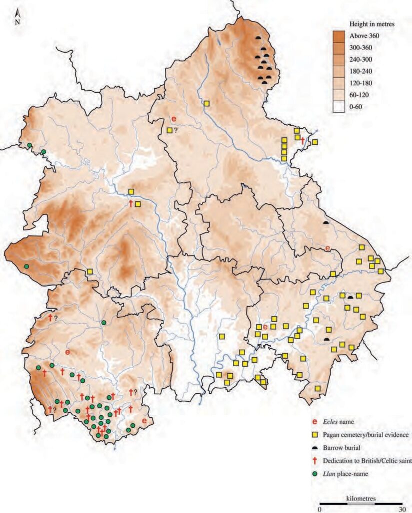
Certainly, known pagan Anglo-Saxon burials are concentrated across the south-eastern parts of the region in south Worcestershire and south-east Warwickshire, with further groups in the Trent valley area of south-eastern Staffordshire and in the Staffordshire Peak District to the north (Fig 5.1). Although it is now accepted that the fashion of grave goods is no reliable indicator of race, the early burials, in particular, do seem to indicate the presence of Anglo-Saxons and suggest that many individuals buried in the cemeteries had played a role among a warrior or social elite. At Wasperton in Warwickshire, a cemetery appears to have continued in use from late Roman into Anglo-Saxon times (Esmonde Cleary 1989, 201; Crawford 1982), perhaps implying the acquisition by an existing native community of cultural traits that were ‘Anglo-Saxon’ in origin. Others seem, however, to represent the burials of a predominantly youthful population that may have been made up of incomers. At Alveston, Warks, there are hints that the community was suffering from stress and starvation (Ford in prep), and the early cemetery at Beckford, Worcs, is also characterised by the apparent poverty of its grave goods (Evison 1996). (But a settlement of both sunken-floored and post-built structures has now been identified nearby at Ryall Quarry that may cast doubt upon this assumption: Barber and Watts 2003.) Burial of a leading elite, on the other hand, is suggested for the pagan barrow burials that spill over into the north-east Staffordshire Peak District from Derbyshire. Here leaders may have grown rich from the lead resources of the area and for the most part these are late (mid 7th-century) secondary burials that have been attributed to the Pecsætan tribe. Burial here took place at a time when paganism was facing the threat of being overwhelmed by Christianity and the barrows were perhaps a deliberate statement of pre-Christian belief. Final phase burials with rich grave goods that again suggest the emergence of a 7th-century elite also seem to be suggested in some Warwickshire cemeteries (Crawford WMRRFA 4). Although the context of individual finds can be difficult to understand, the discovery of a fine dagger pommel at Dinham in Ludlow seems to show the presence of high-status people in that region in the 7th century.
The incidence of the OE hlaw term has sometimes been found to coincide with Anglo- Saxon burial (Hooke 1981b) and this term also occurs in the west of the region. However, mounds may have been constructed to mark meeting places etc, perhaps following a tradition of barrow burial in which the barrow marker established a claim to land proved by ancestral ownership, and actual interment need not have been present in later periods. (The extent to which pagan ‘superstitions’ continued among the general populace after conversion is difficult to determine but the early Church had continually to fight remnants of such belief.) If a language change occurred over the first few centuries of Anglo-Saxon cultural domination this still awaits a full explanation and there is little indication of how strongly the British (Primitive Welsh) tongue had been current in the West Midlands area or had continued in everyday use. Oppenheimer (2006, 415- 16) has argued for the presence of a strain of the Germanic language (closer to Norse) being present in parts of England from pre-Roman times. In this area the survival of British place-names suggests that neither this, nor population change, were major factors here (Hooke 1997). Even among British-speaking communities, it is likely that, as on other numerous similar occasions, one language slipped down the social scale as another became the accepted speech among landowners, scribes etc (cf Gaelic in Lowland Scotland) (Hooke 1997).
Metalwork located as stray finds cannot always be tied in with a known burial place but can sometimes add to our understanding of the identity of Anglo-Saxon tribal groupings already suggested by grave goods. In particular, Ford (1996, 92-6) has noted how the latter suggest a territorial divide through Warwickshire in the Anglo-Saxon period, with the Avon region of central Warwickshire being first subject to cultural and trading influence from Anglian regions to the east (indicated largely by cruciform, small-long, annular, cut-away disc, some great square-headed and possibly pennanular brooches) but with, at some time in the first half of the 6th century, the introduction of disc, followed by saucer, brooches indicating a more dominant commercial link to the south for the lower part of the Avon valley. He argues that the division between what was to become the kingdom of the Hwicce and that of Greater Mercia can be discerned, therefore, by the end of the 6th century. Indeed, some political boundaries may have perpetuated much older territorial groupings, for the Hwiccan kingdom seems to have been established over part of the former late Iron Age Dobunnic territory (which seems to be perpetuated in the distribution of Romano-British coarsewares) (Hooke 1985b, 17-18). Until the Anglo- Saxon period the midland region had no cultural uniformity, looking outwards to core regions beyond. Although the eastern parts of the region continued to look eastwards in pagan Anglo-Saxon times the dominance of Mercia by the 8th century brought a measure of cohesion as this kingdom, spreading from a core region in the valley of the Trent, extended its boundaries as far as the estuary of the Dee and subsumed the kingdoms of the Hwicce and Magonsæte to the south and south-west.
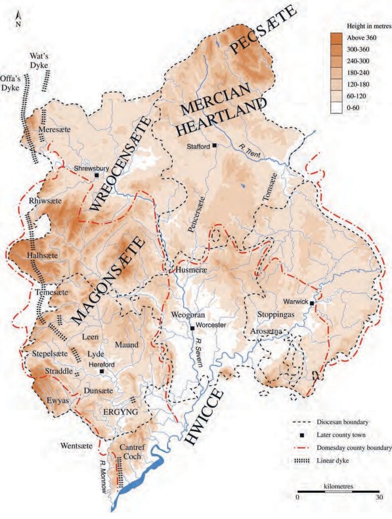
Documentary and place-name evidence has helped to identify folk regions within the 7th-century Anglo-Saxon kingdoms (Hooke WMRRFA 4; Fig 5.2). Because of their location in the Borderland region, some have suggested that the tribal groups that carried a –sæte name may have been of British origin, unlike the ingas-, inga– groups common in eastern England (Higham 1993, 85, 89, fig 3.6) (although the appearance of such names may itself denote assimilation and Anglicisation: J Hines, pers comm). There is one ingas name in the region that applies to a recognisable territory – the Stoppingas of Wootton Wawen. This type of name seems to indicate land given to an Anglo-Saxon leader and his followers relatively early on in the period of post 5th-century Anglo- Saxon colonisation, here apparently granted a block of land with an assessment of about 50 hides across the headwaters of the River Alne in Warwickshire. But who gave this land unit and why did the bulk of the population – if, indeed, large numbers of ‘British’ survived – eventually aspire to identify itself with an immigrant culture? It is important to note that in the midlands we have as much (if not more) evidence for the territorial and political geography of early medieval England as anywhere else in the country.
Little is yet known about pre-Christian ritual, rather than funerary, sites in the region in this period. But Christianity probably helped to eradicate many such sites beyond the main areas of Anglo-Saxon influence. Springs may have played a part as pre-Christian cult centres but, as sources of purifying water, were readily taken over by the Christian Church. Particular trees too lost their significance although the yew, probably already accepted by Roman Christianity, became a feature in many churchyards (where it has been claimed that a few may pre-date the standing church near by). In spite of numerous edicts issued by the early Church banning worship at pagan sites, trees, springs and stones continued to be associated with healing powers. Place-names and landmarks along estate boundaries may indicate other Anglo-Saxon pagan sites, with a number clustered around the area of the Birmingham Plateau. This perhaps indicates a region, close to the border of the Hwiccan kingdom and Greater Mercia, in which paganism lingered (Gelling 1961; 1973; 1978, 158-60, fig 11): the names Wednesbury and Wednesfield are associated with Woden and may owe their existence to Penda, the last pagan Mercian ruler. Close to the northern boundary of the Hwiccan kingdom was Tyes mere, ‘the mere of Tíw’, a Germanic war-god, while Tysoe, ‘the hill spur of Tíw’, lay on the side of Edge Hill, close to its southern boundary, where traditionally a horse figure had been carved on the hillside. (The horse appears, too, in the Godiva legends attached to Coventry, and may even be derived from the Gaulish horse-goddess, Epona, riding out to confer benefits upon her people.) Legend and tradition are other sources that archaeologists can consider. Archaeologically known ‘heathen’ shrines are few: at Blacklow Hill in north Warwickshire two large enclosures full of pits were associated with two, possibly 7th-century, Anglo-Saxon graves, a type of monument which may have drawn upon older roots in its concept but was apparently constructed at a time when Christianity was becoming popular even among the Anglo-Saxons (Blair 1995, 18, 22).
Evidence from the west of the region seems to show Christianity firmly established before the conversion period, although it is not yet clear how much this derived from late Roman Christianity. There are hints of religious continuity at Acton Trussell, Staffs, where the medieval (possibly 11th-century) church stands on a high-status Roman (villa?) site (C Wardle, pers comm). Religious continuity may also be suggested by the ecles place-names which have been taken to indicate surviving British Christian communities in the vicinity. Many scholars have argued that the religion was reintroduced from Gaul in the 5th and 6th centuries, gaining ground amongst British populations, but others see this as the reinforcement of an already established faith. Early ‘British’ Christian inscribed stones are known from Wroxeter in Shropshire and Lanveynoe in Herefordshire.3 The influence of late Roman organisation in the Church has been effectively argued by Bassett (1989).
Burials and cemeteries from the 5th century onwards have been located in small numbers across the Borderland (some others are of uncertain age) and many have interpreted some features as illustrative of British Christian belief, although the presence of a small Anglo-Saxon element is not denied: suggested, for instance, by a (possibly mid 7th- century) potsherd in a ring ditch at Sutton St Michael in Marden, Heref (K Ray, pers comm), or two scramasax-type iron knives and fragments of iron buckle found in a post 7th-century cemetery at Bromfield, Shrops. Other burials, however, were orientated and lacked grave goods (eg three north-east/south-west orientated graves, one certainly in a coffin, from Much Wenlock), perhaps indicative of Christian burial. The recently found 7th- or 8th-century cemetery at Dewsall Court, Heref, is another significant example of a likely Christian cemetery, coinciding here with a dedication to a Celtic saint, St Dewi, and overlying late Roman deposits but lying in a different location to the medieval church (Cotton WMRRFA 4). Ewyas and Archenfield, in south-western and southern Herefordshire respectively, remained Welsh districts until the time of Domesday Book, with British bishops controlling the Church until at least the 10th century. The possibility of re-examining church enclosures (Br. llan) offers another line of enquiry.
Early medieval rural settlement sites have also rarely been identified archaeologically. Even when excavation has located continuous occupation from prehistoric into Roman times, with additional evidence from the medieval period (as at Throckmorton, Worcs), the intermediate occupation layers remain elusive. Roman pottery has, indeed, been located on many deserted medieval sites in Warwickshire but any early medieval phase of settlement on most of these sites remains undiscovered or unidentified. Early sunken- featured buildings (SFBs) have been found in this county at Baginton, Brandon, Stretton- on-Fosse, Hatton Rock, Wootton Wawen and Broom (three dating to the 6th century?). Building features such as postholes have been identified at a number of locations which include a site close to a pagan cemetery at Alveston, Broom (two possible post-built structures, one a hall-house), Bidford-on-Avon, and possibly Wootton Wawen (Palmer 2000). Buildings of the 10th/11th century have been identified at Coton in Churchover parish, and in Worcestershire similar features have been noted at Fladbury (substantial mid 10th-century buildings) and Ipsley (a possible cattle pen) with sunken-featured buildings at Kemerton (Dinn and Evans 1992), and no fewer than seven SFBs at the Ryall Quarry site in Ripple. For Herefordshire, however, Cotton is forced to conclude that ‘there are no rural non-ecclesiastic settlements of this period … whose presence can be clearly verified by reliably contexted ground evidence’ and for Staffordshire Kinsley adds that ‘Apart from Catholme (in Barton-under-Needwood), no finds of the Anglo-Saxon period have been made in rural settlement contexts’ (WMRRFA 4) (although Roman pottery has been found on a small number of medieval village sites, possibly indicating continuous occupation since the late 4th century: Smith 1980, 11, and possibly at Barton- under-Needwood itself). The reason usually given for this is that domestic settlements in the early part of the period were small scale, non-intrusive and probably subject to shift, some perhaps hidden beneath later settlements.
The only substantial post-Roman hamlet to have been located and excavated in the region is that of Catholme in the Trent valley of Staffordshire (Losco-Bradley and Kinsley 2002). Some 65 buildings of various sizes and structures that included wall-post buildings and grubenhäuser were identified on this site, representing several phases of building within clearly defined settlement zones. Occupation on the gravel river terrace may have begun in the Roman period, when the area was at least farmland, with an early Anglo-Saxon settlement and a related cemetery (at Wychnor) continuing in the northern part of the original site. Settlement gradually drifted north-eastwards along the gravel terrace to the area that was excavated after 1973 when quarrying threatened its survival. The excavated settlement apparently consisted of a number of individual farmhouses, with their ancillary buildings, that were established in the mid to late Anglo-Saxon period but went out of use at a date any time between the late 9th and 13th centuries (ibid, 123). Even with extensive excavation, the problem of ethnicity remains unresolved but no major disruption of the agricultural regime was evident at the end of the Roman period. The presence of a north-west European burial rite at Wychnor, ‘Anglo-Saxon’ grave goods and the presence of some 14 grubenhäuser may indicate at least a degree of Anglo-Saxon involvement but, as at Wasperton, arguments have been advanced that the earliest inhabitants of the settlement were Britons:
If indeed the earliest buildings and enclosures pre-date c. AD 600, it seems likely that it was originally peopled largely or entirely, by Britons. Whatever its origins, however, the community swiftly adopted ‘Anglo-Saxon’ architectural forms and buried at least some of its dead with distinctively Germanic artefacts. The buildings and burials could be manifestations of a local British population which had never gone away, but which merely emerged from archaeological invisibility in the later sixth and seventh centuries by adopting the trappings of the ‘Anglicised’ society to the east (Losco-Bradley and Kinsley 2002, 128-9).
Andrew Reynolds’ (2003) recent discussion of rural domestic settlements in early medieval England notes no others in the midland region and a gazetteer updating that produced by Rahtz in 1976 would make a welcome addition to the literature. Our knowledge of settlements is still dominated by the evidence from eastern England and the east midlands where pottery was in greater use. There, Romano-British farmsteads seem to have gone out of use, as pottery scatter also suggests in the west midland region, but a pattern of equally dispersed farms and hamlets took their place (however, it should be noted how frequently Romano-British pottery turns up on later village sites, suggesting a degree of continued preferred site selection, if nothing else). By the mid Saxon period an element of nucleation was taking place in the east midlands, even involving a degree of regularly planned layouts (Brown and Foard 1998, 77). Whether this represents the failure of outlying farmsteads or a deliberate change in social organisation is uncertain and is discussed further below.
The importance of pottery and other artefacts for dating settlements and placing them within the estate network is shown by the evidence from eastern England, but in much of the midlands domestic pottery seems to have gone out of use in the immediate post-Roman period apart from its use for funerary urns. However, this absence may be more illusory than real, as the detailed excavations carried out in the Trent valley site of Catholme show, for over 2000 sherds of handmade pottery, mostly coil-built and probably locally made, were found scattered widely across the site, possibly beginning as early as the 6th century (Vince 2002, 102-10; Losco-Bradley and Kinsley 2002, 123). There were 757 sherds of sub-Roman/Anglo-Saxon pottery from the excavation of well-stratified deposits of c 5th- to 7th-century date at the Upwich salt-making site in Droitwich (Lentowicz 1997), where the dating of the deposits did not solely rely on the ceramics but was rather based on extensive radiocarbon dating. This included ‘grass’-tempered pottery and a range of other well-defined fabrics, some of the pottery being non-locally produced (Hurst & Hemingway 1997, 23). More recently ‘grass’-tempered pottery has been discovered during fieldwalking at Bretforton in south Worcestershire (D Hurst, pers comm), suggesting that it may after all be possible to trace settlement occupation by this means. Some 736 sherds were also found at Broom in the Arrow valley of Warwickshire during excavations carried out in advance of the construction of a new bypass between Evesham and Alcester (Palmer 2000), some of it apparently datable again to the 6th century, and organic-tempered pottery was also obtained from the 6th- to 8th-century settlement site at Ryall Quarry in Ripple, Worcs (Barber and Watts 2003).
Over most of the region, however, it is not until the mid Anglo-Saxon period that pottery begins to appear in the known archaeological record, and then mainly on urban sites, the exception being a number of isolated royal palace sites (see below). Interestingly, pottery found on a small number of Warwickshire rural sites is late Saxon in date, consisting of imported Neots ware and Cotswolds oolitic tempered ware, possibly carried in along the Roman road network — the Fosse Way and Watling Street (S Ratkai, pers comm): does this indicate the late emergence of these sites? At Coton in Churchover, occupation appears to have begun in the 10th/11th century and enclosures and buildings of the period have been found (Palmer WMRRFA 5), and a number of other Warwickshire rural sites have produced 10th- and 11th-century material, among them Pillerton Priors, Goldicote, Loxley, Flecknoe and Ettington, all in the Warwickshire Feldon. The picture is similar in Worcestershire where Cotswold oolitic pottery has been encountered on some rural sites (D Hurst, pers comm). Yet there is no indication, even here, of the frequent usage of pottery found in regions to the south by the late 10th century. Only after the mid 11th century do locally-made wares come into general usage for such items as cooking pots and jugs and pitchers (although a ‘potter’s wood or clearing’ is recorded on the northern margin of Needwood, Staffs, in the mid 10th century: Hooke 1983, 103-7; Sawyer 1968, S 557). Clearly, the list of known sites yielding pottery is likely to grow with excavation.
Nucleation was clearly a gradual process in many areas, often associated with later re- planning, but charter evidence shows conclusively that small farms and hamlets still existed close to estate boundaries in the later part of the early medieval period (Hooke 1985a), in north-east and south-east Worcestershire at least. None of these sites has been investigated archaeologically and habitative field-names elsewhere may suggest other ‘lost’ sites. Another priority must be to try to establish the date of origin of many of the minor farmsteads that first find their way into the documentary record in the medieval period (again, Roman pottery has been found close to some medieval farm sites: Hodder WMRRFA 3). Even less can be said about the region’s villages. It has been argued (Brown and Foard 1998) that nucleation began even before the fragmentation of multiple estates, perhaps under royal or ecclesiastical influence, and at Goltho in Northamptonshire nucleation appears to have preceded the building of a manorial complex (Reynolds 2003, 123-5, 131; Beresford 1987), a point also recently made about settlement nucleation by Tom Williamson (2003). Dating in East Anglia and the east midlands has depended very much upon the ceramics found during intensive fieldwalking projects like those carried out by David Hall in the East Anglian Fenland and the east midlands or by Williamson in Essex (eg Hall 1981; Hall and Coles 1994; Williamson 1986), but there is limited evidence so far from the west midland region to cast light upon the matter (see discussion of the ceramic evidence above). As Crawford (WMRRFA 4) concludes, the desperate lack of excavated settlement evidence for this area should put the need to conduct a more careful excavation of a settlement, should the ghost of an opportunity arise, at the top of the research agenda.
The greatest hope of locating ‘lost’ settlement sites may lie with less intrusive forms of archaeological investigation such as the use of geophysical prospecting, at least in preliminary investigations, and deliberately aimed small-scale excavations not led by the location of building development.
The reoccupation of prehistoric hillforts in the immediate post-Roman period by a lordly elite has been suggested, with The Berth at Baschurch being put forward as a likely candidate (White WMRRFA 3) and perhaps, too, the hillforts of Sutton Walls, Old Oswestry and the Wrekin, but corroboratory evidence is so far lacking. Air photography has, however, produced evidence of another kind of high-status site, for ranges of timbered buildings, interpreted as ‘palaces’, have been identified at Hatton Rock and Long Itchington in Warwickshire and at Atcham in Shropshire. The site at Hatton was, however, in the hands of the Church of Worcester after AD 781 (Sawyer 1968, S 1257) and this may have been an ecclesiastical ‘palace’ building, perhaps with a church — again, this depends upon the dating of the pottery, judged by Hirst and Rahtz (1972–3) to be of 8th- or 9th-century date. A type of black pottery found by fieldwalking on the first of these sites was also found beside the River Dene at Wellesbourne in Warwickshire after bridgeworks upstream — suggesting the presence of another, so far undiscovered, high-status site in a location in which royal assemblies are known to have been held (Hooke 1985b, 204). There are other known royal centres, like Sutton in Marden in central Herefordshire, which may eventually produce further evidence for a focal building or royal residence.
The evolution of the region’s towns is better understood. The ‘dark earth’ deposits found in many sub-Roman centres suggest that in the immediate post-Roman period, or even earlier than this, towns were losing their focal role, although in some places such deposits may represent the wattle and daub of fallen buildings, the role of earth-based buildings having perhaps been underplayed on British, as opposed to continental, sites (R Macphail, pers comm). Places that had been urban have produced evidence, from late Roman times, of silty soil brought in on the feet of livestock mixed with other refuse. At Worcester these soils supported grassland from the 4th to the 10th century, suggesting that parts of the former settlement were being farmed as pasture fields, and there is direct archaeological evidence here, probably within the Roman period defensive circuit, for continuity of occupation through the 5th and 6th centuries, together with continuity in the management of fields around the town (Dalwood 2004; Macphail 2004). Similarly, there seems to have been continuity of occupation at Wroxeter into the 5th and 6th centuries. A tombstone commemorating one Cunorix (c 475) may imply the use of Irish mercenaries to defend the town (White WMRRFA 3). A mid 6th-century resurgence led to the construction of some buildings of considerable size and status (White and Barker 1998, 2002). After that, urban settlement at Wroxeter apparently diminishes. Settlement is also likely to have continued at Droitwich, where salt production continued (Hurst 1997), and 5th-century occupation has been inferred at Kenchester and Leintwardine in Herefordshire, although a break seems to be evident in the east of the region at Alcester and Wall (Ray WMRRFA 4). (But a sword mount found at Alcester on the edge of a Romano-British burial site, and a later crozier head of ivory, may be indicative that more remains to be found here on the outskirts of the Roman town: S Ratkai, pers comm).
If the towns lost their role in the early part of the Anglo-Saxon period, their re-growth seems to have been brought about by further threats. Burh defences are some of the most noteworthy features of the period and many of the early towns of the west midland region developed as defended urban centres during the Danish invasions. However, the deliberate fostering of trade and markets is a feature sometimes overlooked. Tamworth was already an important Mercian royal vill in the 8th century; it may have earlier borne the name Tomtun. Offa had a palace there and it was already defended before it became a centre for the reconquest of the Danelaw under Æthelflæd. Hereford may have originated as an ecclesiastical centre in the later 7th century but its defences appear to have been built in the mid 9th century before those of any other midland burh (Boucher 2002, 4; Baker WMRRFA 4), presumably constructed against Welsh attack. Worcester, already described as (ad) metropolim Huicciorum ‘(at) the metropolis or capital of the Hwicce’ in the mid 8th century (Sawyer 1968, S 1254; Birch 1885–99, B 166) and another episcopal city, was defended by Æthelflæd and her husband Æthelred, ealdorman of Mercia, in the late 9th century, when it was ordered that the burh should be built ‘for the protection of all the people’ (Sawyer 1968, S 223), and they shared market dues there with the Church of Worcester. The defences were located during the Deansway excavations in 1989 and suggest a defended annexe added to the north side of an earlier enclosure around the cathedral with later suburban development at Sidbury. Later Æthelred and Æthelflæd established a burh at Shrewsbury and refortified Hereford and Worcester (AD 910). After her husband’s death, Æthelflæd went on to build fortresses at Bridgnorth on the Severn (AD 912), Stafford (AD 913), and Warwick (AD 914). Both Stafford and Shrewsbury made use of the defence offered by marshland and a river meander, Shrewsbury on the Severn and Stafford on the Sow.
The burhs, whether defended against the Welsh or the Danes, are likely to have made a considerable impression on the landscape of early and later medieval England and were well populated by the mid 11th century: Baker (WMRRFA 4) estimates populations at that time of around 2000 for Worcester, 1200 for Shrewsbury, about 1500 for Warwick, and 1300 for Stafford. But the defended towns were also meant to develop as economic centres, with good roads serving a market for the surrounding countryside (Hooke 1980). The burhs were not alone, for the salt-producing centre of Droitwich, a wíc or ‘place of trade’, may have had 800 inhabitants by that date. Neither were the burhs set at new locations, for several coincided with ecclesiastical minster foci, among these Hereford and Worcester.
Other aspects of commercial activity before the development of urban markets urgently demand enquiry: although it has been suggested that the production of pottery at Stafford pre-dated the establishment of the burh, others prefer to accept a later industry developing there once the burh had begun to develop (S Bassett and S Ratkai, pers comm), as at Derby and Northampton. Neither is a great deal known about the region’s place within the commercial activity of the country as a role. When Mercia spread its authority as far as the Thames in the 8th century, the Church of Worcester maintained a trading post on the river which presumably brought profits back into the region but apart from salt, originally a commodity over which the kings of the Hwicce had claimed control, little is known about the goods being traded — such as agricultural produce or wool — and whether wealth was actually coming into the region or being exploited elsewhere. On urban sites, however, pottery, perhaps associated with high-status sites, is not uncommon. Much of the pottery found within towns was imported from outside the region (eg Stamford and St Neot’s wares) although Stafford ware, produced between the late 9th century — or later — and the 11th century, was widely distributed across the west midland region (and along the north Welsh coast, even reaching as far afield as Dublin: Ford 1998–9, 33, fig 18). An urgent review of other midland pottery collections is necessary.
Baker (2003) has raised many questions regarding urban growth in the early medieval period which could be archaeologically addressed: what authority supplied the impetus for growth and how did the Church and political leaders interact, given the factors of military necessity and commerce? How fast did towns develop as urban centres in the pre-Scandinavian period? What elements of planning can be detected (haga enclosures within towns are noted in the charters of pre-Conquest England, sometimes with their dimensions) and when did burgage plots come into being? Crafts were well established in the later Anglo-Saxon towns but how much evidence is there of zoning within the towns? This seems to be evident, for instance, in the location of pottery manufacture at Stafford. Furthermore, how did towns react with the countryside? Again, links between town and country are attested in Domesday Book that may have had their origins in the burh’s role as a centre of refuge but which continued to play an economic and marketing role. Archaeological excavation can reveal much about the status and quality of life of those occupying urban locations — about the crafts practiced and where they were located, or about building types and roads. Pottery found in urban settings is one form of evidence for the development of towns and the extent of trade: Hereford may have had a local pottery industry by the end of the 10th century (Vince WMRRFA 4; but the kilns at Stafford were earlier). Some towns acquired a new function when they became the foci of the new counties established at the end of the early medieval period. Warwick had been a border town and probable place of exchange on the boundary between the Hwiccan and Greater Mercian kingdoms (Fig 5.2); Hereford and Worcester had been important ecclesiastical centres and, together with Stafford and Shrewsbury, had been defended burhs before they took on the new administrative role. But many other small medieval towns have seen little archaeological investigation and the beginnings of their urban character remain little known.
The system of marketing before the growth of towns also needs investigation. What have been termed ‘productive sites’ have been identified in a number of non-urban sites such as the area to the east of Bidford-on-Avon, Warks, where metal detecting has produced items such as silver coinage (15 coins) and bronze metalwork (12 pieces: brooches, strap-ends and ornamental fragments) of middle Saxon (8th/9th- century) date, together with an Anglo-Saxon gold mount decorated with a calf ’s head in beaded wire filigree, probably of 8th-century date and perhaps part of a hanging bowl or an ecclesiastical object (representing the symbol of St Luke). This represents a concentration of objects that are unlikely to have been casual losses and may have accumulated at a market site, perhaps one at which ‘cattle, sheep, horses and other commodities were bought and sold’ and goods perhaps exchanged (Wise and Seaby 1995). Beyond the great emporia, mostly lying outside our region, were other smaller places involved in the distribution and collection of low-value goods, sometimes with organised production workshops. How far can such sites be identified in the West Midlands?
Defensive features
The burhs were defended centres, often with inner enclosures known as hagæ, a term that suggests protection and defence (Hooke 1981a, 247-8), but the most impressive linear defence system is the earlier Offa’s Dyke that runs north–south through the Borderland close to the Welsh border (Fig 5.2). Opinions may differ about the reasons for its construction: Hill and Worthington (2003, 110-12) envisage it as a border earthwork constructed when the Welsh of Powys were attacking sites in Mercia. (Brooks 1989, 168- 9, suggests another reason for early Welsh raids on the midlands.) The dyke is likely to have been constructed on the instigation of Offa, a powerful leader who was not averse to using the trappings of Imperial Roman power to promote his own image: the dyke in many ways emulates Hadrian’s Wall in its symbolism and scale. (Indeed, it has been claimed that the dyke follows an earlier earthen rampart built by the Roman emperor Severus at the beginning of the 3rd century AD.) Shorter stretches of linear boundaries in the same region seem to have been earlier than Offa’s Dyke: Wat’s Dyke may have been of mid or later 6th-century construction, protecting the area around Chester (White WMRRFA 3 but dating N Baker, pers comm), while excavations at points on the Rowe Ditch, which cuts across prehistoric field systems in the Arrow valley in Pembridge, suggest a date for its construction c AD 650, ie in a post-Roman context in a period that suffered major cultural dislocation, perhaps in the face of some other rapid and major incursions by the Anglo-Saxons into British territory (Ray WMRRFA 4). Other stretches of linear earthwork or cross-valley dykes, like the Birtley dyke near Lingen and another near Wigmore, both in north Herefordshire, have yet to be placed into context but may mark out other British enclaves (see Ray WMRRFA 4). While most castles in the region date from after the Norman Conquest, Norman intervention began in Herefordshire at an earlier date when Edward the Confessor granted lands to his Norman associates: mottes at Richard’s Castle, Ewyas Harold and Hereford itself date from the pre-Conquest period, reflecting the troubled political background of the Border region and the presence of new Norman landholders.
Minster Foundations
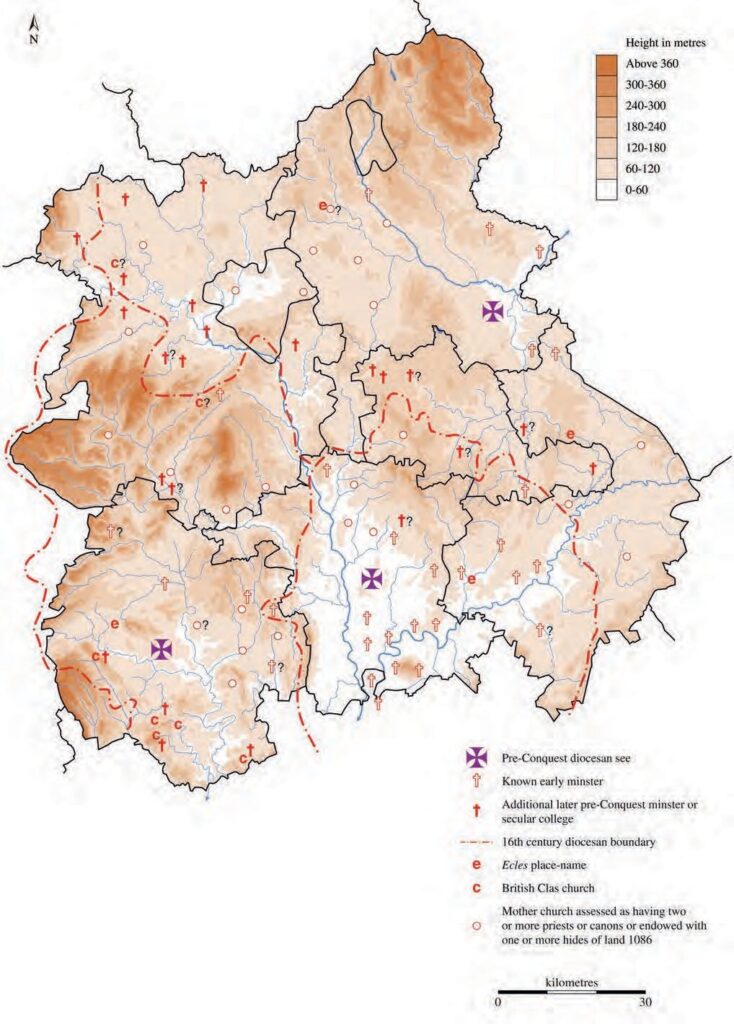
Apart from the burhs, it has been claimed (Blair 1988) that minster foundations were the nearest thing to urban sites in early Anglo-Saxon England; many, indeed, became towns in their own right (above), gaining revenue from the control of marketing and acting as consumers of goods and services. Lichfield, never a burh but a short-lived diocesan centre by the 8th century, is a candidate for early medieval urban status (Wardle, notes submitted to WMRRFA). Again, archaeology has begun to supply information about many of these centres: at Evesham, for instance, the reformed Benedictine community appears to have developed the town in the later 11th century, with a degree of urban planning, and similar initiatives probably took place at Pershore and Coventry. But what of the other early minsters (Fig 5.3)? Hanbury stood within the ramparts of an Iron Age hillfort, a location which perhaps provided an expression of power over the surrounding landscape. Although Alcester was probably the ‘celebrated place called Alne’ where an ecclesiastical council was held in AD 709, and remained a royal estate, no evidence of its probable early minster has been found. This was perhaps because its ecclesiastical role was taken over by Evesham Abbey, which by the time of the Norman Conquest had managed to gain control of most of the area in the Arrow valley that seems to have been earlier dependent upon Alcester. A territory initially dependent upon Alcester, assessed at very close to 100 hides, can be reconstructed (Hooke 2003a, 73-4, also fig 3). The location of early minsters is better known within the Hwiccan kingdom due to the full records maintained by the Church of Worcester but even here many have yet to be identified on the ground (Inkberrow, Ismere, Bredon etc). In Herefordshire and Shropshire, estate groupings and sculpture may suggest the location of pre-Conquest minsters (Croom 1988; Cotton WMRRFA 4). Sculpture fragments can be indicative of early church foundations and the role of the Church in acting as a focus for local territories also offers important evidence when the extent of their medieval parochiae can be reconstructed (eg for Hanbury see Dyer 1991, 18; for Wootton Wawen see Bassett 1983, 70; Hooke 1985b, 136, fig 33). By the end of the period, the great minsters stood out as virtually the only stone buildings (eg the churches at Wootton Wawen and Tredington) in a landscape where other buildings were small and constructed out of timber and thatch. The minster buildings not only expressed the power of God on earth but, perhaps inadvertently at this stage, the role and status of the Church itself.
Communications
Most of the major Roman roads appear to have remained in use (Hooke 1981a, 300-14), facilitating communications across the region, although some towns like Tamworth and Burton developed on sites a little distance away from the main network lines. A network of saltways, some using stretches of the Roman network, was also used for one of the region’s main commodities of trade (Fig 5.4). River transport also gave access to the region and Worcester developed its river trade by the 10th century (Dalwood WMRRFA 4) but the dates at which bridges were constructed across the region’s rivers remain largely unknown (the bridge at Worcester was repaired in 1088); fords and ferries were earlier means of effecting crossings.

An understanding of the rural landscape offers more of a challenge. Opportunities in advance of redevelopment are less concentrated than in towns and rarely coincide with research questions. Neither does archaeological excavation necessarily reveal a great deal about field systems etc, although the techniques of environmental archaeology can be invaluable in suggesting land use over a limited area. In the early medieval period, a change seems to have taken place in the organisation of large estates. The collection of taxes under Roman rule seems to have given way, in many areas, to the more traditional form of taking tribute in kind, perhaps linked to other changes taking place in the rural economy (Faith 1997, 4-5, 102). The need to provide urban centres and the army with grain was removed, and traditional pastoral farming may have increased in importance, also perhaps a response to a deteriorating climate, although excavations at Salford Priors and Broom indicate continued exploitation of the cleared and cultivated river terraces along the Arrow, perhaps accompanied by settlement ‘drift’. New ‘multiple’ estates were to emerge, and some of their central places may have continued to occupy sites that were previously important. It is within such estates that the settlement patterns characteristic of the period may have emerged. Brown and Ford (1998, 81) have conjectured whether ‘the process of nucleation was associated with a fundamental reorganisation of the decayed late Roman landscape’ as ‘the middle Saxon economy was dominated by pastoralism’, but the change seems generally to have occurred later, in the mid to late Anglo-Saxon period, when the amount of land used for cultivation was again being extended, as attested by alluviation in river valleys arising from soil erosion on newly cleared land. The end of a major period of relatively well-dated alluviation has been radiocarbon dated to the 8th century at Droitwich, perhaps signifying such a change in land use, with the onset of the alluviation occurring in the 7th or 8th centuries (Hurst and Hemingway 1997), although in the vicinity of Droitwich such evidence may, alternatively, reflect the fresh removal of tree cover upstream in association with fuel provision for salt making (D Hurst, pers comm).
It has also been commonly suggested that intensified land use coincided with the fragmentation of estates into ‘township’ communities and the rise of the ‘proto-manor’ (Fox 1981; Hooke 1998, 114-21) as lords were under pressure to augment the economies of their individual estates, and that it was also associated with the introduction of open- field farming as a means of achieving increased revenue. But fresh thinking has suggested that these changes, involving the development of open-field agriculture, occurred before estate fragmentation, taking place upon the inland of the great estates (Williamson 2003, 18). As noted earlier, this places the move towards settlement nucleation and open-field agriculture within large (‘multiple’?) estates rather than within splintering local lordships, attributing nucleation to the improvement of efficiency within the larger unit rather than the smaller. In this scenario, the system might well be copied by new manorial lords. But estate fission is again almost impossible to date. Williamson (ibid, 155-9) has gone further in examining the influence of soils and geology, for he has pointed to the narrow window of opportunity for ploughing on pelo-stagnogley soils that may have encouraged farmers to live in a nucleated settlement, adopting the centralised open- field system of agriculture. He also argues that the presence of meadowland encouraged settlement nucleation and that an abundance of hay enabled growing populations to expand the arable at the expense of woodland and pasture. However, ceramic evidence (Warwickshire, above) may point to the relatively late establishment of nucleated village centres in the ‘champion’ regions of the West Midlands.
Farming and field systems
Can archaeology help to identify the nature of early field systems? Methods of retrogressive analysis have shown some promise but have again thrown up as many questions as they have answered. In north-west Herefordshire a pattern of coaxial fields near Pembridge was apparently established in the prehistoric period for it was cut by the post-Roman Rowe Ditch in the Arrow valley to the west of Kington (White 2003, 74-5). Bassett (1986) attempted to show other coaxial systems in west Warwickshire but, if genuine, these would need to have survived through later patterns of open-field farming. Neither can the extent of the early open fields yet be verified. Charter boundaries seem to suggest that there were often enclosed fields beyond the open-field nucleus in the later part of the early medieval period although these were subsequently taken into the medieval open fields. This seems to have been the case near the western boundary of Tredington in Warwickshire and in Bishopton near Stratford in the same county (Hooke 1999, 85-6, 123), some of these perhaps associated with boundary settlements lying some distance from the manorial nucleus. The areas under open field were often those that had already been most intensively developed in the Roman period, extending, especially, across the Feldon of Warwickshire and the Vale of Evesham in Worcestershire. It was these regions that became the classic ‘champion’ lands of medieval times, with extensive and regular open-field systems.
Far less is understood about farming outside these regions. Most have been classified as regions of ‘irregular’ field systems with more limited areas of open field often associated with smaller but more numerous settlement clusters. Only where populations were denser in medieval times, as in the more fertile plain areas of Shropshire, the Wye valley of Herefordshire and central and south-east Staffordshire, did extensive and regular open- field systems develop. An argument for the intensity of arable farming and settlement nucleation over much of Herefordshire has, however, been advanced by the county’s chief archaeologist, Keith Ray, who bases his arguments upon the number of deserted medieval settlements now known and the amount of ridge and furrow recorded, which he links with the surprisingly large number of plough teams recorded in Domesday Book (Darby 1977). Landscape archaeology can thus suggest possible land use but cannot always offer proof or period of settlements: the number of ploughs recorded in 1086 may still indicate a landscape of scattered manorial nuclei, often small, surrounded by scattered farms with plough teams that had still not been drawn into a central estate focus and thus reduced in number. Archaeology has yet to take up this challenge as well as so many others. However, it is clear that a multidisciplinary approach is needed to establish the framework of estates and territories within which settlements developed and field patterns emerged. Neither should geology and soils be ignored, as Willliamson’s (2003, 155-9) theories indicate (above).
Changing estate and settlement patterns
There is a need to understand the region not only in a wider English setting but in the light of changes that were occurring in the early medieval period across Europe. A major reorganisation and stabilisation of settlement was taking place in many parts of north-west Europe during the later 7th and the 8th centuries, although the trend could continue later, as in Denmark (Hamerow 2002). It seems to reflect an intensification of production, new systems of distribution and the changed socio-economic structure of rural communities within larger territories. New administrative structures replaced old tribal loyalties and distant centres became important foci of activity. Hamerow (ibid, 123) rejects the break-up of multiple estates as a prime factor in settlement shift but agrees with those who see the shift to heavier soils as a means of meeting ‘the demands of new secular and ecclesiastical landlords for surplus, and to provision the populations of the newly established emporia’. She envisages a process that began here in the 8th century but lasted at least a century, proceeding at different rates in different regions. Crucially, crop and animal husbandry was also changing: agricultural production was intensifying in the 8th and 9th centuries after a period dominated by a strong pastoral element: monasteries and towns were growing ‘consumer’ communities and the demesne system was asked to produce a substantial agricultural surplus, perhaps most readily effected in open fields, by crop rotation and greater use of the mouldboard plough. A bigger labour force was required and labour was pooled, and plough oxen shared, with a collective right over such resources as pasture and pannage.
Water resources
Another feature of economic development is the watermill, the best known that found on the royal vill of Tamworth, Staffs, and thought to date from the 8th century. Two others have recently been found close to the royal centre of Marden in Herefordshire. On rural manors, mills were being built in Warwickshire in the 10th century, recorded in charters and place-names. Most sites recorded lay in the central Avon valley: at Milcote, Alveston, Clopton and Ruin Clifford in Old Stratford and in the Stour valley at Blackwell in Tredington, although a mill at Bluntesige may have been at Blunt’s Green in Tanworth (Hooke 1996). In Worcestershire there was a mill on the Church of Worcester’s manor of Caldinccotan in Bredon, recorded in the later 10th century (Hooke 1981a, 267-9, fig 3.28) and mills also on estates of Pershore Abbey. It is not perhaps fortuitous that these were all church estates, for innovation was probably first effected on important royal and ecclesiastical estates. Mill pools were often associated with the capture of eels in Domesday Book but river and estuarine fisheries were already operating at an earlier date (ibid, 268-72).
Marginal land use
Some of the most intriguing questions are concerned with the regions of more marginal land use. Abandoned field systems at the Burrels in Sutton Coldfield (M Hodder, pers comm) and recent studies of palaeobotanical data of the area around Metchley Roman fort on the Birmingham Plateau suggest that wood pasture was re-emerging as the dominant land use of the area in the post-Roman period although there was some subsequent cultivation of rye (Greig 2005). This would tie in with the place-name evidence for much of north Worcestershire, north Warwickshire and elsewhere in the region (similar results have been obtained at King’s Pool in Stafford: J Hunt, pers comm). Pre-Conquest charters reveal a pattern of resource management in which links were maintained between estates in regions of intensive agricultural development and those in more marginal areas. Ford (1976) has argued that such links may go back into at least the late Iron Age when, in a similar economy, herds and flocks were driven to seasonal pastures many kilometres distant. Some of these links may have survived or been initiated anew in the Anglo-Saxon period. Whether actual movement of stock always occurred is not known but a pattern of north-west/south-east route ways across Warwickshire linking the Arden and Feldon may have begun as drove ways linking the two regions (Hooke 1998, 161, fig 55; 2003a, 71, fig 2). By the early medieval period, estate links seem to have continued as a means of utilising contributory resources, wooded regions in particular providing pasture for herds of swine as well as timber resources.
Another use of marginal regions that emerged in the early medieval period was that of hunting. Again, place-name terms cannot be accurately interpreted but a boundary feature referred to in charters as a haga apparently bounded areas of ground in wooded countryside and seems to have been the forerunner of the game reserve or park, often found on the boundaries of royal estates. By the time of Domesday Book, haia features represented the same enclosures and were stated in that source to be enclosures for the capture of deer (Hooke 1989). They were particularly frequent in the Welsh Borderland where much land had been laid waste by Welsh attacks and were also frequent in areas due to be designated as Royal Forest by the Normans. Landscape archaeology in the midland region has so far failed to identify these features on the ground but detailed studies of hedges, hedgebanks and woodbanks might yet provide more information.
The recognition of regional pays
The recognition of regional variation, expressed as landscape pays, must be a major aim if causal factors are to be fully understood. Historic Landscape Characterisation projects are underway or nearing completion across the region and have helped to identify landscape regions across the West Midlands. One of the first studies of this kind was carried out in Warwickshire in the early 1990s under the auspices of the Countryside Commission and Warwickshire County Council. It included an analysis of the historical landscape regions of the county, primarily as a guide to future countryside planning and management, and involved the production of detailed maps and reports covering the whole of Warwickshire and adjacent parts of surrounding counties (Warwickshire City Council, 1991, 1993; Hooke 1993). Since then, English Heritage has fostered similar projects more closely geared towards archaeology and the historical landscape, developing models for the analysis, management, protection and enhancement of the historic environment. Such studies have enabled archaeological and historical monuments to be seen within the wider landscape setting that is unique for each character area recognised. Evolutionary trends can also be examined and perhaps better understood, together with the factors that have led some regions to include areas where ancient features have apparently had a better chance of survival whereas, in others, rural landscapes have been irrevocably changed, largely by enclosure or urbanisation.
The recent development of Historic Environment Records, replacing Sites and Monuments Records, must also be a step forward but at present the evidence for the early medieval period is seriously incomplete. Gaps in the settlement record, in particular, cannot necessarily be taken to indicate an absence of population. For the first time in history, the documentary record for parts of the region offers a substantial body of information about the nature and development of the rural landscape. Pre-Conquest charters provide detail about land use features in some regions, as such much of Worcestershire, which is difficult to match from any other source, although place-names are a more ubiquitous source of information (Hooke WMRRF 2004; 1981a, 1985b, 1990, 1999; volumes of the English Place-Name Society where completed; for Herefordshire see Coplestone-Crow 1989). Charters are few in number for the Borderland, however, and the charters of the Book of Llan Dâv that describe estates in southern Herefordshire may offer details about local topography but do not disclose a great deal about land use other than indicating the presence of woodland in some areas now relatively open (Davies 1978; Book of Llan Dâv 1979; Hooke WMRRFA 4). Most regional classifications have been based upon medieval and later landscapes (eg designations such as Rackham’s (1986, 4-5) ‘Ancient’ and ‘Planned Countryside’; this and others are discussed more fully in Hooke 2006, 9-22). It is clear, however, that later regional characteristics were already clearly evident in the early medieval period and a priority is to establish how early they became apparent. Here research must clearly look beyond the beginning of the period back into prehistoric and Roman times. One of the clearest distinctions evident is that between the Warwickshire Arden and Feldon but that reality was rather more complicated is shown by detailed study (eg Hooke 1981a, 1985b; Fox 1989).
Archaeobotanical evidence is urgently needed to provide more information about the nature of early medieval woodland. Well-wooded regions are clearly indicated by place-name evidence but the exact interpretation of the terms used needs clarification. Unprotected areas of woodland, such as the extensive areas used as wood pasture where stock foraged and often destroyed tree seedlings, are not likely to have consisted of dense woodland and the ubiquitous leah term in such regions has been interpreted by Wager (1998) as ‘secondary woodland’; the term may, however, have implied the specific economic usage of ‘open woodland used as wood pasture’ (as at Metchley) (Hooke 1989 and 2008). The distribution of marginal areas is also closely related to frontier regions and, hence, territorial organisation (Hooke 1986). Waterlogged deposits, in particular, offer considerable potential for archaeological investigation, as attested by the discovery of the two water mills near Wellington associated with the royal centre of Marden.
Concentrated activity such as that currently being directed towards an understanding of the manors of Marden, with specific enquiries in mind, may offer the best way forward rather than leaving archaeology to the vagaries of ‘rescue’ archaeology. The Arrow Valley Project in Herefordshire that was funded by English Heritage and Herefordshire Council is an example of what a systematic study of a clearly defined area can hope to produce, providing as it does a framework for subsequent archaeological investigation. There have been similar earlier studies, usually carried out on a much smaller scale, such as my own work in the Arrow Valley of Warwickshire in the late 1970s/early ’80s or Bassett’s (1983) in Wootton Wawen, or studies of single parishes like Dyer’s (1991; 1994, 51-76) work at Hanbury and Pendock, but these lacked the funding and organisation allotted to the Herefordshire project, which also involved ‘key-hole’ excavation on a Roman settlement site and at points along the Rowe Ditch. Here, field survey and aerial photography revealed earthworks of medieval settlements and even a new medieval town at Lyonshall, showing that there was a large population living in the area during the medieval period with hints of greater settlement nucleation than hitherto expected. It is a sobering thought, however, that the marshalling of known information, studies of aerial photographs, fieldwalking, and even some selective trenching, failed to produce evidence of early medieval settlements.
Discussion during the Framework meetings also noted the importance of re-examining existing collections, perhaps subjecting some to modern analytical techniques, and the need to complete the examination and publication of some early work. Other problems have arisen because of the constraints of present planning policies, for developers cannot be expected to fund primary research, and the costly examination of such features as palaeochannels is hard to guarantee: the need for detailed pollen studies of a general area such as the Avon valley of Warwickshire has to be a deliberately funded project. The maintenance of a midland database might be a particularly useful tool. In investigating the evidence for the early medieval period in the West Midlands, the inconsistency of the region’s Sites and Monuments Record (now Historic Environment Record) has been especially highlighted. This is especially obvious for this period, when almost every medieval village in Staffordshire is classified under the date AD 410+ as the category runs from this date to 1066, with only a handful of villages classified under this date in Shropshire and Warwickshire (the latter reflecting actual archaeological evidence). Above all, the necessity to adopt a multidisciplinary approach to problems is clearly evident if archaeology is to answer specific questions. A selected estate entity might provide a suitable framework for investigation but the need for archaeological intervention is shown by the failure of historical/documentary studies to answer unresolved problems.
WMRRFA 2004: West Midlands Regional Research Framework for Archaeology, series of seminars 2003–4. It must be noted that some of the papers presented at this seminar were never submitted to the Management Committee and could not, therefore, be used to produce this report.