Prehistory

Introduction

As recently as 25 years ago the prehistory of the London region could have been described, not unfairly, as comprising little more than a striking collection of artefacts fished from the Thames or dug from the gravel terraces that marked its ancient floodplains upstream and downstream from the City. The few excavated sites (for example, Caesar’s Camp at Heathrow (Grimes and Close- Brooks 1993) and the Neolithic causewayed enclosure at Yeoveney Lodge, Staines (Robertson- Mackay 1987)) were isolated monuments unrelated in space and time; virtually nothing was known of the overall pattern of human habitation of which they formed a part.

The work undertaken since, largely without the benefit of otherwise standard predictive techniques such as aerial photography and fieldwalking, has begun to transform our understanding, and revealed much that is new and unexpected. The implementation of PPG 16 from 1990 (DoE 1990) made it possible to target a far wider range of geologies and topographies, and a recent review of PPG 16 (Phillpotts 1997) identified a marked increase in known prehistoric finds and find spots, particularly for the Neolithic and Bronze Age. Yet the amount of prehistoric evidence recorded in modern excavations is still small in comparison with virtually all other periods, and the fact that so many sites remain to be published is a major obstacle to understanding.

The need, therefore, for better data cannot be over-emphasised and baseline surveys (eg Wessex Archaeology 1996; Wymer 1999 see below) are much needed. A detailed review of aerial photography evidence is also long overdue. The establishment of firm regional chronologies is an equally urgent requirement. London has a major – yet untapped – potential to contribute (as with, for example, Needham et al 1997) to national chronological frameworks, including projects such as Ancient Human Occupation of Britain (AHOB), a five year study funded by the Leverhulme Trust and involving The Natural History Museum and partners led by Professor Chris Stringer.

Similarly, recent regional and period-based thematic and synthetic reviews have begun to address the lack of published material, and the preparation of a range of interdisciplinary site- specific and thematic reports for central and outer London is welcome (Sidell et al 2002). New approaches to interpretation seek to reconstruct the ways in which human beings perceived and moved through their physical world, in an ‘archaeology of inhabitation’ (Barrett 1994; Barrett et al 2000). Advances in the new discipline of biomolecular archaeology are providing new opportunities for the determination of sex and kinship within human burials, palaeopathology, human origins and migrations, and studies of animal and plant domestication (Renfrew 2000).

We now not only recognise the tremendous potential of the region to tell us about the human communities who populated it in the half a million years or so before the Roman conquest; we also recognise the pivotal importance of the River Thames for human habitation in the region.

The Thames was a barrier, a link, a resource, a focus for votive and ritual activity and an artery of communication. The questions for future research lie in understanding the Flandrian regression/transgression sequence, the effect of the oscillating relative sea and river levels on local plant, animal and human communities, and in understanding – through interdisciplinary studies – the relationship between the Quaternary gravel terraces and the Holocene floodplains (see Fig 3). Geomorphological evidence can increasingly be used to predict the location of surviving sites.

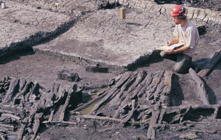
Recently located inter-tidal sites, such as the drowned forest at Erith (Seel 2000) and the pile-built ‘bridge’ or structure at Nine Elms, Vauxhall (Haughey 1999, 18–19) now need further work to characterise and date the material. In turn, such work will shed new light on the historic collections of artefacts dredged from the river, just as the study of river management, ballast dumping and dredging activities may help to explain how and when antiquarian finds came to be deposited (Cotton 1999). In the study of London’s prehistory, therefore, the perspective will necessarily shift between the global, regional and local, from the North Sea basin to the Thames Valley or to a single pit.

P1 Framework objectives

P1.01: Establishing firm regional chronologies tied into national chronological frameworks, taking the opportunity to clarify extant terrace sequences

More information on this question
URI:
https://researchframeworks.org/rfla/researchframework/v1/question/question-620e596519a62
More information:
Status:
Active
Authority to change status:
Date accepted:
01/02/2002
Date of next review:
Found in the following Frameworks:
Research Framework for London Archaeology
Categories:
Chronology, Greater london authority

P1.02: Carrying out baseline surveys for the Pleistocene in the London region, focusing on reconstructing geomorphology, ecology, ecosystems and climate, hydrology, and vegetational (eg building on the simple model of the Holocene vegetational succession in London created by Rackham and Sidell 2000), and faunal development (addressing the bias towards botanical reconstruction, attributed to the preserved evidence)

More information on this question
URI:
https://researchframeworks.org/rfla/researchframework/v1/question/question-620e59651c4df
More information:
Status:
Active
Authority to change status:
Date accepted:
01/02/2002
Date of next review:
Found in the following Frameworks:
Research Framework for London Archaeology
Categories:
Geomorphological survey, Greater london authority, Climate

P1.03: Making comprehensive use of predictive digital terrain models based on borehole and other geophysical data, and opportunistically examining known sites and exposures

More information on this question
URI:
https://researchframeworks.org/rfla/researchframework/v1/question/question-620e59651ca47
More information:
Status:
Active
Authority to change status:
Date accepted:
01/02/2002
Date of next review:
Found in the following Frameworks:
Research Framework for London Archaeology
Categories:
Geophysical survey, Greater london authority, Digital terrain model

P1.04: Understanding the many and changing roles of the River Thames through the periods of prehistory since Oxygen Isotope Stage (OIS) 12 (478,000–423,000 BP), and the relationship between the many fluvial and terrestrial environments, between the floodplains and the gravel terraces, and between inner and outer parts of the Thames Estuary

More information on this question
URI:
https://researchframeworks.org/rfla/researchframework/v1/question/question-620e59651cff5
More information:
Status:
Active
Authority to change status:
Date accepted:
01/02/2002
Date of next review:
Found in the following Frameworks:
Research Framework for London Archaeology
Categories:
Gravel, Oxygen isotope analysis, River, Greater london authority

P1.05: Reviewing palaeoecological reconstructions with specific regard to cognitive issues, such as the nature of the animal presence and human interaction with wild and domestic species needs research

More information on this question
URI:
https://researchframeworks.org/rfla/researchframework/v1/question/question-620e59651d5c7
More information:
Status:
Active
Authority to change status:
Date accepted:
01/02/2002
Date of next review:
Found in the following Frameworks:
Research Framework for London Archaeology
Categories:
Greater london authority

P1.06: Understanding environmental change, especially climatic change, with respect to behavioural implications in the past (eg for shelter and migration) and providing context and coherence to research into future climate change

More information on this question
URI:
https://researchframeworks.org/rfla/researchframework/v1/question/question-620e59651dca5
More information:
Status:
Active
Authority to change status:
Date accepted:
01/02/2002
Date of next review:
Found in the following Frameworks:
Research Framework for London Archaeology
Categories:
Climate change, Greater london authority, Environmental change

Early scavengers and hunters: the Lower Palaeolithic (c 500,000–38,000 BC)

Fig 12 A Lower Palaeolithic pointed flint handaxe

In terms of numbers of artefacts recovered, the London region is one of the most important in Europe for the Lower Palaeolithic period, and contains a series of key sites and localities. Reinvestigation of several of these sites in recent years (for example, Conway et al 1996) has underlined their continuing potential to contribute to ongoing reassessments of the original data, some of it now over a century old. Guidance from English Heritage (1998b) has emphasised to planning authorities and developers the importance of managing the surviving Palaeolithic resource.

London also has one of the best understood river sequences in Europe: a lengthy terrace sequence from the Anglian to the mid Devensian with expanses (albeit diminishing) of fine-grained sand and silt deposits and a plethora of known sites and individual artefacts.

Valuable work has been carried out on the Thames terrace sequence within the London region (Gibbard 1994; Gibbard 1995; Bridgland 1994; Bridgland 1995; Bridgland et al 1995). However, problems remain regarding the detailed correlation of some parts of the terrestrial sequence with marine Oxygen Isotope Stages.

Palaeogeography is seen as a fundamental area of research, and the Southern Rivers and English Rivers Palaeolithic Projects (Wymer 1999; Wessex Archaeology 1993; Wessex Archaeology 1996) provide a strong basis on which to build further work. Fundamental questions about how geomorphology and ecology influenced human activity, about the opportunities or hindrances that topography and environment posed to people, and about how and why people manipulated particular features of the landscape, remain to be answered. There is evidence for the presence of people in London since at least the Anglian diversion of the Thames (OIS 12), with the exception of the Ipswichian Interglacial (OIS 5e) and probably some time around it (parts of OIS 6 and 4). Specific objectives can be identified with the aim of reconstructing environmental conditions in the Palaeolithic, concentrating on dry, open areas (as opposed to river channels), marshes and densely forested areas. Again, understanding hydrology and establishing highly resolved chronologies for the period should be key research priorities.

The period also requires a particular focus on understanding the initial hominid colonisation and subsequent re-colonisations of peninsula Britain. It is not possible to conceive of these peoples’ lives without understanding the terrain and ecosystems. Apart from the well known Swanscombe skull (Bridgland 1994, 205), thought to belong to a female dated to OIS 11, direct fossil evidence for the types of humans who produced Palaeolithic artefacts in the London region is non-existent.

P2 Framework objectives

P2.01: Creating baseline surveys on topography and landscape

More information on this question
URI:
https://researchframeworks.org/rfla/researchframework/v1/question/question-620e59651e3d1
More information:
Modelling pleistocene geomorphology and ecology. Complete ecosystems need to be reconstructed across geographic zones, followed by the superimposition of settlement locations to build models of regional settlement patterns. The Palaeolithic has been studied in much less detail than the Holocene, therefore, this balance needs redressing. Local and regional analysis of new sequences and landscapes (such as completed for the Crayford silts (Wessex Archaeology 1999)); it is possible, for instance, that palaeo-landsurfaces exist beneath the surviving expanses of the Langley Silt Complex (‘brickearths’) in west London (Gibbard 1994). Re-examining geological sections at known sites, using interdisciplinary teams with Quaternary scientists
Status:
Active
Authority to change status:
Date accepted:
01/02/2002
Date of next review:
Found in the following Frameworks:
Research Framework for London Archaeology
Categories:
Lower palaeolithic, Greater london authority, Topography

P2.02: Establishing a sound chronology for the period (clearly distinguishing between dating and correlating sequences, events and horizons)

More information on this question
URI:
https://researchframeworks.org/rfla/researchframework/v1/question/question-620e59651ea36
More information:
Further technological research into dating techniques, including optically stimulated luminescence (OSL) and tephra chronology, and the testing of biostratigraphic dating against radiometric methods. Co-ordinating a programme to test and develop dating techniques could yield valuable results. If it could be justified on a site-by-site basis, then opportunistic testing of different dating techniques could be carried out cost effectively in the context of commercial archaeological projects
Status:
Active
Authority to change status:
Date accepted:
01/02/2002
Date of next review:
Found in the following Frameworks:
Research Framework for London Archaeology
Categories:
Lower palaeolithic, Optically stimulated luminescence, Chronology, Greater london authority

P2.03: Targeting categories of research and geographic areas that commercial fieldwork should address

More information on this question
URI:
https://researchframeworks.org/rfla/researchframework/v1/question/question-620e59651f065
More information:
Biostratigraphic research especially on interglacial deposits, in order to understand the prevailing ecological systems. This should include opportunistic sampling for pollen, vertebrates and invertebrates (eg Nightingale Estate, Hackney (Green et al 2000)). Targeting specific areas and deposits with high potential: Stoke Newington, Ealing and Acton, Crayford, Southall and Ilford, and physiographic zones such as the Langley Silts, the edges of gravel terraces and palaeoconfluences
Status:
Active
Authority to change status:
Date accepted:
01/02/2002
Date of next review:
Found in the following Frameworks:
Research Framework for London Archaeology
Categories:
Lower palaeolithic, Palaeochannel, Gravel, Biostratigraphy, Greater london authority

P2.04: Extending the analysis of different modes of flintworking (defined by, for example, Wymer 1999, 6–12 and Barton 1997, 19–24) to establish whether, as White and Schreve suggest (2000, 15–20), they are culturally significant

More information on this question
URI:
https://researchframeworks.org/rfla/researchframework/v1/question/question-620e59651f5d6
More information:
Status:
Active
Authority to change status:
Date accepted:
01/02/2002
Date of next review:
Found in the following Frameworks:
Research Framework for London Archaeology
Categories:
Lower palaeolithic, Flint, Greater london authority

P2.05: Developing models which, rather than focusing on cultural-historical explanations seek a different focus using issues of human perception, human behaviour and cognitive issues using

More information on this question
URI:
https://researchframeworks.org/rfla/researchframework/v1/question/question-620e59651fb73
More information:
London material (for example from Crayford (Bridgland 1994, 250), from the Southall mammoth kill site (Wymer 1991), and from megafauna assemblages)
Status:
Active
Authority to change status:
Date accepted:
01/02/2002
Date of next review:
Found in the following Frameworks:
Research Framework for London Archaeology
Categories:
Lower palaeolithic, Greater london authority

Later hunters: the Upper Palaeolithic and Mesolithic (c 38,000–4000 BC)

The Upper Palaeolithic is poorly represented nationally and, unsurprisingly, there are few in situ assemblages or associated faunal remains of this date from the London region. The lack of sites may be due to a number of factors, climatic, cultural and/or taphonomic. Areas in London that may produce further material include the Kempton Park and Shepperton Gravels of the floodplain, and the base of the Langley Silts Complex (AGL 2000, 54).

The early Upper Palaeolithic is represented in London by a single broken leaf point from Ham (Ellaby 1987, 53) and a small flint assemblage from Heathrow (Lewis in prep a). There is currently no evidence for human presence in the region in the millennia on either side of the Late Glacial Maximum, centred on 18,000 BP. However, humans were certainly present at the end of the Late Glacial (late Upper Palaeolithic), as the important ‘long-blade’ sites in the Colne Valley at Three Ways Wharf, Uxbridge (Lewis 1991; Lewis in prep b), and Church Lammas, Staines (AGL 2000, 52), demonstrate. These two sites provide vital regional evidence for the climatic transition between the Late Glacial and the Flandrian, enhanced by small faunal assemblages which at Uxbridge furnished two radiocarbon dates centring on c 10,000 BP. The important Upper Palaeolithic site at Sandy Lodge, Rickmansworth underlines the importance of the Colne.

Much of the evidence for the Mesolithic consists of isolated finds of flintwork, although other stone, bone and antler artefacts have been recovered from the Thames. However, recent excavations across different landscape types have produced a range of in situ early Mesolithic material, including lithic and faunal assemblages and important environmental data. These include the Colne Valley at Three Ways Wharf, Uxbridge (Lewis 1991; Lewis in prep b), the high ground on West Heath, Hampstead (Collins and Lorimer 1989), and the shoreline of a silting Late Glacial lake in Bermondsey, Southwark (AGL 2000, 52). The Lea Valley is generally very important for early Mesolithic evidence, especially sites that are preserved in peat, such as the nationally important Rickoff’s Pit in Hertfordshire (Bonsall 1977), and these are a key research objective of the Thames Northern Tributaries Project (Lewis 1995). Publication of key sites will enable inter- and intra-site comparisons regarding issues such as cultural and environmental change, seasonality, hunting strategies, raw material procurement, tool manufacture, use and discard.

P3 Framework objectives

P3.01: Carrying out comprehensive baseline surveys

More information on this question
URI:
https://researchframeworks.org/rfla/researchframework/v1/question/question-620e596520118
More information:
The approaches set out in the Thames Northern Tributaries Project (Lewis 1995) could provide a useful regional starting point. Publication of key site assemblages include those of early Mesolithic type from Three Ways Wharf, Uxbridge (Lewis 1991; Lewis in prep b), the Old Kent Road (Rogers 1990), Creffield Road, Acton (Burleigh 1976; Bazley et al 1991) and a rare late Mesolithic assemblage from Amersham in Buckinghamshire
Status:
Active
Authority to change status:
Date accepted:
01/02/2002
Date of next review:
Found in the following Frameworks:
Research Framework for London Archaeology
Categories:
Palaeolithic, Mesolithic, Greater london authority

P3.02: Understanding what London looked like

More information on this question
URI:
https://researchframeworks.org/rfla/researchframework/v1/question/question-620e596520787
More information:
Geomorphological mapping of key feature types (such as lake basins, river channels and channel/dry land interfaces, as well as deeply sealed, surface-intact sites in the floodplains) is of importance in predicting the likely whereabouts of human activity. Predictive modelling using integrated borehole and geophysical ground investigation programmes have already proved valuable (Merriman 1992; Bates and Bates 2000). The nature and chronology of the hunter-gatherer impact on the natural environment requires greater resolution to establish, for instance, the extent to which the charcoal-rich horizons noted in the middle and upper valleys of the Colne and Lea are the result of human intervention
Status:
Active
Authority to change status:
Date accepted:
01/02/2002
Date of next review:
Found in the following Frameworks:
Research Framework for London Archaeology
Categories:
Palaeolithic, Geomorphological survey, Borehole survey, Greater london authority

P3.03: Addressing aspects of continuity and change in the nature of the subsistence strategies pursued by human groups: how did they change and develop through time, and why?

More information on this question
URI:
https://researchframeworks.org/rfla/researchframework/v1/question/question-620e596520faa
More information:
Status:
Active
Authority to change status:
Date accepted:
01/02/2002
Date of next review:
Found in the following Frameworks:
Research Framework for London Archaeology
Categories:
Palaeolithic, Agriculture and subsistence, Greater london authority

P3.04: Explaining why the late Mesolithic is so poorly represented in the London region needs addressing. The validity of a model wherein communities retreated up the major tributaries and the valley sides in the face of rising sea and river levels needs testing

More information on this question
URI:
https://researchframeworks.org/rfla/researchframework/v1/question/question-620e59652167e
More information:
Status:
Active
Authority to change status:
Date accepted:
01/02/2002
Date of next review:
Found in the following Frameworks:
Research Framework for London Archaeology
Categories:
Palaeolithic, Mesolithic, River, Greater london authority
Fig 13 A Neolithic/Bronze Age blade knife from the Royal Docks Community School site in Newham

Early farming communities: the Neolithic and early Bronze Age (c 4000–1500 BC)

Evidence for the late Mesolithic and the Mesolithic–Neolithic transition is still poorly represented. In the centuries after 4000 BC there is evidence for the accelerating transformation of the landscape by human communities. This eventually manifested itself through the construction, maintenance and periodic reworking of earthen monuments of various forms on the gravel terraces away from the river floodplains, particularly in west London (Barrett et al 2000). This area appears to demonstrate a distinction between finds-rich monuments on the lower terrace gravels and ‘clean’ monuments on the upper terraces. Moreover, it displays contrasting distribution of prestige finds on the terrace gravels (few) as opposed to the Thames (many).

Apart from Runnymede Bridge (Needham 1991), domestic settlements have largely eluded identification, but may lie sealed beneath alluvium. Earlier Neolithic flint assemblages from Rainham (AGL 2000, Gz HV14; Macdonald 1976) and Ham may be relevant here, and urgently require assessment and publication. The subsistence strategies of these scattered local communities seem to have been geared (at least initially) to pastoralism rather than full mixed agriculture, and continued to be supplemented by the gathering of wild resources. However, without further large assemblages of botanical and faunal remains for comparison, the full significance of those from Runnymede Bridge remains difficult to gauge. Food residues on pottery from Runnymede confirm the continuing importance of gathered foodstuffs in the earlier Neolithic. Does the presence of gathered fruits and nuts in a series of later Neolithic pits in west London (AGL 2000, 73–4) and elsewhere similarly reflect the wider economy, or are these specially selected ‘placed deposits’? Increasingly, cosmology was expressed in physical form through feasting, funerary ceremony/burial ritual and the deposition of ‘placed deposits’ in the river and on land, in the form of copper artefacts from 2500–2400 BC and bronze artefacts from 2200–2100 BC.

Ceramic studies have highlighted distinctions which need further elucidation such as the association of Peterborough ware with sheep/cattle lipids and of grooved ware with pig lipids (Gibson 1999, 161–2). But whilst Peterborough ware is particularly well represented as a class in London, the region scarcely contributed a single date to the recent national accelerator programme (Gibson and Kinnes 1997).

P4 Framework objectives

P4.01: Elucidating the nature of the Mesolithic to Neolithic transition

More information on this question
URI:
https://researchframeworks.org/rfla/researchframework/v1/question/question-620e596521c12
More information:
The pollen and coleoptera sequences at West Heath, Hampstead (Greig 1989), are relevant to wider debates regarding pre-Neolithic horticultural experimentation and the elm decline, but neither is secured by independent dating, and there is no direct evidence for any accompanying human presence. Elsewhere the floodplains probably provide the
Status:
Active
Authority to change status:
Date accepted:
01/02/2002
Date of next review:
Found in the following Frameworks:
Research Framework for London Archaeology
Categories:
Mesolithic, Bronze age, Neolithic, Pollen, Insect remains, Greater london authority

P4.02: Reconstructing the environment and ecology on a regional basis

More information on this question
URI:
https://researchframeworks.org/rfla/researchframework/v1/question/question-620e5965223e0
More information:
The west London gravel terraces have revealed a complex landscape dominated by earthen monuments of various forms (Barrett et al 2000), and this material needs to be compared, using environmental data, with sites away from the gravels, including West Heath, Hampstead (Greig 1989), on the northern heights, and Runnymede Bridge (Greig 1991), Bramcote Green, Bermondsey (Thomas and Rackham 1996) and Erith (Seel 2000) in the Thames floodplain. The examination of species composition, for example within the submerged forests at Erith, is adding important detail
Status:
Active
Authority to change status:
Date accepted:
01/02/2002
Date of next review:
Found in the following Frameworks:
Research Framework for London Archaeology
Categories:
Bronze age, Gravel, Greater london authority

P4.03: Researching the potential for categorisation of settlement sites

More information on this question
URI:
https://researchframeworks.org/rfla/researchframework/v1/question/question-620e596522d7e
More information:
Future research should consider whether the lack of ‘settlement sites’ is more apparent than real, and if so, what it signifies. In this context the lithic assemblages from Brookway (AGL 2000, Gz HV14), Rainham (AGL 2000, Gz HV14; Macdonald 1976) and possibly Ham require assessment and publication
Status:
Active
Authority to change status:
Date accepted:
01/02/2002
Date of next review:
Found in the following Frameworks:
Research Framework for London Archaeology
Categories:
Settlement, Bronze age, Lithic scatter, Greater london authority

P4.04: Examining the influence of landscape, establishing whether the Thames confluences were considered important settings for different types of monument

More information on this question
URI:
https://researchframeworks.org/rfla/researchframework/v1/question/question-620e596523424
More information:

Can the apparent dichotomy in west London between monuments on the lower and upper terraces be upheld? Similarly, can the differential distribution of prestige finds between the terraces and Thames there be explained? Does the pattern represent the presence of different communities? Or are the terraces and the river simply different parts of a landscape used by people who drew clear distinctions between the most appropriate settings for particular actions?

Status:
Active
Authority to change status:
Date accepted:
01/02/2002
Date of next review:
Found in the following Frameworks:
Research Framework for London Archaeology
Categories:
Monument, Bronze age, River, Greater london authority

P4.05: Gathering and analysing data to understand the subsistence economy. In the absence of good botanical and faunal assemblages (such as Runnymede Bridge), the subsistence economy is poorly understood

More information on this question
URI:
https://researchframeworks.org/rfla/researchframework/v1/question/question-620e596523b46
More information:
Status:
Active
Authority to change status:
Date accepted:
01/02/2002
Date of next review:
Found in the following Frameworks:
Research Framework for London Archaeology
Categories:
Bronze age, Agriculture and subsistence, Greater london authority

P4.06: Establishing a (long overdue) dated regional ceramic sequence which includes an analysis of fabrics and vessel contents

More information on this question
URI:
https://researchframeworks.org/rfla/researchframework/v1/question/question-620e596524158
More information:
Status:
Active
Authority to change status:
Date accepted:
01/02/2002
Date of next review:
Found in the following Frameworks:
Research Framework for London Archaeology
Categories:
Ceramic, Bronze age, Greater london authority

Later farming communities: middle Bronze Age to middle Iron Age (c 1500–150 BC)

Archaeologist with clipboard sitting on the edge of a trench containing timber
Fig 14 Recording a Bronze Age timber platform at Atlas Wharf, Tower Hamlets

The monument-dominated landscapes of the Neolithic and early Bronze Age were gradually incorporated into an increasingly organised and recognisably modern agricultural landscape given over to a subsistence economy apparently founded on a mixed farming regime. On the gravel terraces, co-axial field systems serviced by droveways and waterholes were laid out by communities who lived initially in small and latterly aggregated open settlements (eg Muckhatch Farm (Needham 1987; AGL 2000, 88) and North Shoebury, Essex (Wymer and Brown 1995; AGL 2000, 88)). These were accompanied, at any rate in the early part of the period, by flat-grave cremation cemeteries.

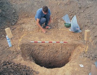
A normative burial rite disappears in the centuries after 1000 BC. The role and status of late Bronze Age ringforts (eg Carshalton (Adkins and Needham 1985; AGL 2000, Gz ST22, 89,92) and possibly Mayfield Farm (Merriman 1990; AGL 2000, Gz HO18)), and of the few defended enclosures of hillfort type (eg Caesar’s Camp (AGL 2000, Gz MT1) and Warren Farm, Romford (AGL 2000, Gz HV1)), remain obscure. In the floodplains there is evidence for rising base levels and correspondingly intensive activity in the form of the construction of wooden trackways (eg Bramcote Green, Bermondsey (Thomas and Rackham 1996; AGL 2000, 87, Gz SW11)).

Some of the locally higher sand islands in the Southwark and Bermondsey areas were under plough for short periods in the mid second millennium BC (AGL 2000, 91), and at least one field here had been manured (Drummond- Murray et al 1994, 254).

The period witnessed a steady rise in, and then a diminution of, river finds, reflecting a European-wide phenomenon (Needham and Burgess 1980; Fitzpatrick 1984; Bradley 1990; Thomas 1999). It is possible that this pattern in the consumption of prestige goods is intimately connected with the generation of agricultural surpluses in the field systems which were set back on the gravel terraces (Yates 1999). Can the metalwork deposition in the Thames be linked with the propitiation of supernatural or elemental forces, for example at the tidal head of the river, and can the metalwork be used to map the whereabouts of the shifting tidal head at different times (cf Needham and Burgess 1980, 452)?

Archaeologist the edge of a half excavated pit.
Fig 15 A large, middle Bronze Age pit at Harmondsworth

Did the deposition of weaponry accompany funerary/burial ceremonies or feasts, or can it be linked with the competitive destruction of valuable property to gain social prestige (Bradley 1990)? Why did the headwaters of tributary streams such as the Wandle attract a wide range of activities connected with feasting and the deposition of placed deposits including metalwork hoards? What part, if any, was played in the physical deposition of such items from structures of the sort recently located within the intertidal zone at Vauxhall (Cotton and Wood 1996, 14–16)?

Plant remains, pollen and field systems provide evidence of agricultural intensification from the middle/late Bronze Age (eg Phoenix Wharf, Bermondsey (Merriman 1990, 25; AGL 2000, 88)). Wooden structures suggest locally intensive use of the floodplain (AGL 2000, 89). Although limited, the early and middle Iron Age evidence hints at the continued use of an organised landscape, with some limited environmental evidence for both pastoral and arable economies (AGL 2000, 105).

The middle and Lower Thames are often assumed to be the localities in which Deverel-Rimbury ceramics first appeared, though there are still virtually no dates available for their inception or development. There is an urgent need for the publication of domestic Deverel-Rimbury assemblages, in order to balance a middle Bronze Age ceramic record hitherto dominated by cemetery groups (Barrett 1973). Following the publication of extensive late Bronze Age ceramic assemblages from, for example, Runnymede Bridge (Needham 1991) and Petter’s Sports Field (Needham 1990), the local sequence of plain and decorated post-Deverel-Rimbury ceramics is relatively well-dated and understood. The same cannot, however, be said for the succeeding early and middle Iron Age sequences, which would benefit from the publication of key assemblages.

Excavation site with a number of archaeologists working on various features
Fig 16 A Bronze Age double-ditch round barrow at Whitehill Road near Gravesend

P5 Framework objectives

P5.01: Re-evaluating the core/periphery model proposed for the Thames Valley in the Bronze Age (Barrett and Bradley 1980).

More information on this question
URI:
https://researchframeworks.org/rfla/researchframework/v1/question/question-620e596524775
More information:
Which identified relationships between the Upper and Lower Thames and between the river valley and its hinterland, on the basis of new evidence
Status:
Active
Authority to change status:
Date accepted:
01/02/2002
Date of next review:
Found in the following Frameworks:
Research Framework for London Archaeology
Categories:
Settlement, Bronze age, Greater london authority

P5.02: Re-evaluating the burial evidence.

More information on this question
URI:
https://researchframeworks.org/rfla/researchframework/v1/question/question-620e596524f55
More information:
Including undated inhumations and cremations, in order to identify first millennium remains. Radiocarbon dating of burial features is imperative in the light of finds of unfurnished inhumations of Iron Age date in Britain (Haselgrove et al 2001)
Status:
Active
Authority to change status:
Date accepted:
01/02/2002
Date of next review:
Found in the following Frameworks:
Research Framework for London Archaeology
Categories:
Radiocarbon dating, Iron age, Burial, Greater london authority

P5.03: Clarifying the mechanisms that prompted agricultural intensification.

More information on this question
URI:
https://researchframeworks.org/rfla/researchframework/v1/question/question-620e5965255eb
More information:
Is there a link between such intensification and the production and consumption of prestige goods? Establishing more, better dated evidence for the subsistence economy. The balance between pastoral and arable economies and patterns of subsistence are areas for further study, but these require improved data sets, particularly the retrieval of good faunal assemblages
Status:
Active
Authority to change status:
Date accepted:
01/02/2002
Date of next review:
Found in the following Frameworks:
Research Framework for London Archaeology
Categories:
Bronze age, Agriculture and subsistence, Iron age, Agriculture, Greater london authority

P5.04: Understanding the relationship between the wooden trackways in the floodplain and the settlements to which they presumably led.

More information on this question
URI:
https://researchframeworks.org/rfla/researchframework/v1/question/question-620e596525b5c
More information:
What was happening in the areas between the wetlands and the settlements? What light do the trackways shed on woodcraft and woodland management?
Status:
Active
Authority to change status:
Date accepted:
01/02/2002
Date of next review:
Found in the following Frameworks:
Research Framework for London Archaeology
Categories:
Woodland, Trackway, Wetland, Greater london authority

P5.05: Identifying the roles that ringforts played in the developing settlement hierarchy of the late Bronze Age.

More information on this question
URI:
https://researchframeworks.org/rfla/researchframework/v1/question/question-620e5965262ab
More information:
And their relationship, if any, with the few succeeding early Iron Age sites of hillfort type such as Caesar’s Camp on Wimbledon Common (AGL 2000, Gz MT1) or Warren Farm, Upminster (AGL 2000, Gz HV1)
Status:
Active
Authority to change status:
Date accepted:
01/02/2002
Date of next review:
Found in the following Frameworks:
Research Framework for London Archaeology
Categories:
Hillfort, Settlement, Bronze age, Iron age, Greater london authority

P5.06: Preparing settlement plans

More information on this question
URI:
https://researchframeworks.org/rfla/researchframework/v1/question/question-620e596526ac2
More information:
It may be hard to define complete settlement plans for open settlements, where scattered roundhouses and unenclosed features extend over several hectares. Nonetheless, it is imperative that large enough areas of such sites are examined to determine where settlement ends and other activities, such as stock pens and fields, begin. Exploring the extent to which less hospitable geologies such as the London Clay were exploited. Is the absence of sites merely apparent, the result of the comparative lack of success of standard predictive techniques on such terrain, or real? Mapping and characterising metal detected finds, and more general finds mapping, to inform consideration of the exploitation of the claylands
Status:
Active
Authority to change status:
Date accepted:
01/02/2002
Date of next review:
Found in the following Frameworks:
Research Framework for London Archaeology
Categories:
Settlement, Bronze age, Iron age, Greater london authority

P5.07: Understanding the origins of the metalwork sequence from the Thames

More information on this question
URI:
https://researchframeworks.org/rfla/researchframework/v1/question/question-620e596527205
More information:
A review of metallurgical industries to try and establish the extent to which metalworking took place locally, by looking at the evidence for clay moulds and iron deposits in Surrey (AGL 2000, 88, 109)
Status:
Active
Authority to change status:
Date accepted:
01/02/2002
Date of next review:
Found in the following Frameworks:
Research Framework for London Archaeology
Categories:
Bronze age, Metal, Iron age, Metal processing site, Greater london authority

P5.08: Refining and dating the local ceramic sequence

More information on this question
URI:
https://researchframeworks.org/rfla/researchframework/v1/question/question-620e59652789c
More information:
Petrological analysis of fabrics, in order to characterise the production, sourcing, styles and influences of London’s ceramic assemblages, and a usable form and fabric typology for the region. Once this work has been established comparisons with material from Kent, Essex, Surrey and the Upper and middle Thames Valley will allow London to be considered within its south-eastern context
Status:
Active
Authority to change status:
Date accepted:
01/02/2002
Date of next review:
Found in the following Frameworks:
Research Framework for London Archaeology
Categories:
Bronze age, Iron age, Greater london authority

P5.09: Constructing models for cultural links and boundaries and, in turn, a focus on wider questions about the political and socio-economic role of the Lower Thames at the time

More information on this question
URI:
https://researchframeworks.org/rfla/researchframework/v1/question/question-620e596527e84
More information:
Status:
Active
Authority to change status:
Date accepted:
01/02/2002
Date of next review:
Found in the following Frameworks:
Research Framework for London Archaeology
Categories:
Bronze age, Boundary, Greater london authority

P5.10: Understanding the place of lithics in the region at this time?

More information on this question
URI:
https://researchframeworks.org/rfla/researchframework/v1/question/question-620e5965283e0
More information:
Important assemblages from Runnymede Bridge and elsewhere await further study and publication
Status:
Active
Authority to change status:
Date accepted:
01/02/2002
Date of next review:
Found in the following Frameworks:
Research Framework for London Archaeology
Categories:
Bronze age, Iron age, Lithic scatter, Greater london authority

P5.11: Exploring seasonal craft activities such as salt production and weaving

More information on this question
URI:
https://researchframeworks.org/rfla/researchframework/v1/question/question-620e59652899a
More information:
gaining an understanding of the sources and processes used in the manufacture of iron and quernstones (AGL 2000, 92)
Status:
Active
Authority to change status:
Date accepted:
01/02/2002
Date of next review:
Found in the following Frameworks:
Research Framework for London Archaeology
Categories:
Salt production site, Bronze age, Iron age, Greater london authority

Dynastic polities to urban hinterland: the late Iron Age and early Roman period (c 150 BC–AD 50)

The period from 150 BC is characterised in some parts of the Thames Valley by agricultural intensification involving the re-alignment of long-established field boundaries and the establishment of new types of enclosed settlements. Political elites began to emerge in certain areas of southern Britain, their presence linked with the appearance of early ‘enclosed oppida’ (Haselgrove 1989, 10–12).The latter were usually larger and more accessible than hillforts, and encompassed a wide range of craft activities.There is no local evidence for the presence of later ‘territorial oppida’ like Silchester, St Albans or Colchester, though stretches of linear earthworks such as Grim’s Dyke remain poorly dated or understood. However, there is at least one possible site of this type in the London area, at Uphall Camp on the River Roding near Ilford (Greenwood 1989; Greenwood 2001), with a possible second reported from Woolwich (Greenwood 1997). Other settlement types include the small conquest-phase rectilinear enclosures such as Moor Hall Farm, Rainham (AGL 2000, Gz HV11), and Gun Hill, Tilbury (Drury and Rodwell 1973) that overlook the Essex marshes. It has been suggested that these might be local versions of Continental Viereckschanzen (Greenwood 1997, 160).There are also larger enclosed sites such as Loughton Camp, Ambresbury Banks (Morris and Buckley 1978, 22), Charlton Camp (Elliston Erwood 1916), Caesar’s Camp (Hounslow, Grimes and Close-Brooks 1993) and Wimbledon (AGL 2000, Gz MT1).

Coinage, in the form of imported Gallo-Belgic gold staters, was in circulation from the middle of the 2nd century BC, and the earliest locally produced coins (the chill-cast tin bronze ‘potins’ of north Kent) appear a little later (Haselgrove 1988). In the decades after Caesar’s invasions of 55 and 54 BC, wine amphorae and metal drinking and/or sacrificial vessels appear in the graves of certain sections of the populace in Sussex, Hertfordshire, Kent and Essex (Creighton 2000, 201–4). Direct Roman influence was increasingly felt in these areas through cross-Channel trade contacts which quickened after c 20 BC. Rome apparently maintained close links with certain favoured southern British dynasties from this time. On present evidence, London appears to have been on the western periphery of the primary contact zone.

More generally, the late Iron Age metalwork deposition in the Thames is of national significance and marks out the London region for the period. It could be argued that the coins and other items of prestige metalwork from the region were deliberately deposited in a recognised boundary zone between competing power blocs. In the light of the recent identification of traces of late Iron Age settlements along the river is this model sustainable?

The question of a pre-Roman settlement is still uncertain. Millett (1990, 89) has argued that it was precisely because there was no strong late Iron Age presence in the area that Londinium was sited where it was. The sustainability of this argument may be examined not only through evidence for continuity in the landscape, but also through a comparison of the pre-Roman landscape with the immediate post- Roman period. The road lay-out and the need for the bridge at London, suggest that Watling Street, north and south, and Stane Street, are later (part of a package that included the new bridge and town).

P6 Framework objectives

P6.01: Evaluating potential oppida

More information on this question
URI:
https://researchframeworks.org/rfla/researchframework/v1/question/question-620e596529453
More information:
Uphall Camp (Greenwood 1989; Greenwood 2001) and Woolwich (Greenwood 1997) are of regional importance and require publication. It will be valuable to clarify the relationship between these sites and other extensive settlements further out in the Thames estuary on the Hoo peninsula (Williams and Brown 1999, 17) and at Rochester.
Status:
Active
Authority to change status:
Date accepted:
01/02/2002
Date of next review:
Found in the following Frameworks:
Research Framework for London Archaeology
Categories:
Roman, Iron age, Greater london authority

P6.02: Assessing stretches of linear earthworks such as Grim’s Dyke which remain poorly dated or understood.

More information on this question
URI:
https://researchframeworks.org/rfla/researchframework/v1/question/question-620e596529b96
More information:
It is possible that further earthworks lie unrecognised in the wooded claylands of the northern heights
Status:
Active
Authority to change status:
Date accepted:
01/02/2002
Date of next review:
Found in the following Frameworks:
Research Framework for London Archaeology
Categories:
Roman, Iron age, Earthwork, Greater london authority

P6.03: Assessing the relationship of the London region to the core south-east zone of coinage, oppida, Continental imports and elite burials in the period following Caesar’s invasions

More information on this question
URI:
https://researchframeworks.org/rfla/researchframework/v1/question/question-620e59652a12e
More information:
Status:
Active
Authority to change status:
Date accepted:
01/02/2002
Date of next review:
Found in the following Frameworks:
Research Framework for London Archaeology
Categories:
Roman, Iron age, Burial, Coin, Greater london authority

P6.04: Examining the evidence for a phase of renewed agricultural intensification in the London region at this time

More information on this question
URI:
https://researchframeworks.org/rfla/researchframework/v1/question/question-620e59652a753
More information:
Status:
Active
Authority to change status:
Date accepted:
01/02/2002
Date of next review:
Found in the following Frameworks:
Research Framework for London Archaeology
Categories:
Roman, Iron age, Agriculture, Greater london authority

P6.05: Elucidating various elements in the settlement pattern from the small rectilinear enclosures to the larger enclosed sites.

More information on this question
URI:
https://researchframeworks.org/rfla/researchframework/v1/question/question-620e59652acdf
More information:
(eg can the attribution of Viereckschanzen be sustained?) How do they compare with other elements in the local landscape?
Status:
Active
Authority to change status:
Date accepted:
01/02/2002
Date of next review:
Found in the following Frameworks:
Research Framework for London Archaeology
Categories:
Roman, Iron age, Enclosure, Greater london authority

P6.06: Examining the Roman foundation of Londinium from the perspective of pre-Roman settlement and continuity

More information on this question
URI:
https://researchframeworks.org/rfla/researchframework/v1/question/question-620e59652b470
More information:
Status:
Active
Authority to change status:
Date accepted:
01/02/2002
Date of next review:
Found in the following Frameworks:
Research Framework for London Archaeology
Categories:
Roman, Iron age, Greater london authority

P6.07: Identifying a pre-London road pattern?

More information on this question
URI:
https://researchframeworks.org/rfla/researchframework/v1/question/question-620e59652bcd5
More information:
For instance, was there a Silchester–Colchester by-pass road? It should be possible to find a London–Winchester road and many more local roads (Bird and Bird 1987); was it not more likely that road transport was used rather than local river transport?
Status:
Active
Authority to change status:
Date accepted:
01/02/2002
Date of next review:
Found in the following Frameworks:
Research Framework for London Archaeology
Categories:
Roman, Iron age, Road, Transport, Greater london authority

Leave a Reply