The West Midlands does not constitute a readily identifiable region, since topographically it is very varied, including, as defined in the present survey, parts of two major river valleys, the Severn and the Trent. It is also characterised by a variable geology ranging from pre-Cambrian to Pleistocene, though the largest area is covered by Triassic Mercian Mudstone deposits. The terrain ranges from the peaks of Staffordshire in the north to the fertile vales of the Severn in the south, and the uplands of Herefordshire to the west. This encompasses a region which historically included frontier zones, such as the Welsh Marches, and in other periods included parts of distinct different political regions, such as during the Danelaw when this boundary stretched across Staffordshire separating north and south. The region also boasts an unusual resource, salt, as well as other minerals, and was not short of basic energy resources such as wood and coal. Such a diverse region offers greater challenges in characterisation as it is likely to contain considerable variation in cultural traits and life styles, reflecting the variable economic and environmental backgrounds of different parts of the region.
The general absence of large-scale research programmes that encompass large parts of this area has also tended to deprive it of any substance as a viable research area, in contrast with other more homogeneous parts of the country such as East Anglia and the Thames valley. Consequently, one of the main objectives of the research framework process, in addition to setting targets for research, should be to develop the concept of the West Midlands more formally as a research context.
The papers forming the basis for this research assessment and agenda were delivered at the research audit presentation and seminar session of 2002-3. This assessment overview aims to address many of the same themes as were explored in Understanding the British Iron Age: an agenda for action (Haselgrove et al 2001).
Though the periods of Bronze Age and Iron Age are broadly distinguishable, there is less clear definition of development within these periods, and the transition from one period to another is also less well defined in the West Midlands than some other areas. The problem with the latter is exacerbated by the difficulties with the calibration curve for c 800-400 BC, though multiple dates and the use of Bayesian statistics can overcome this to some degree (Haselgrove et al 2001, 5). There is a need consequently for more effort on this dating front rather than less as a result of this problem. The knock-on effect of relatively few radiocarbon dates has been that well-dated ceramic sequences covering this whole period are generally patchy, and so, in Worcestershire for instance, the Bronze Age component is only just coming into focus. This shortage of scientific dates, and the additional shortage of associated contemporary material culture (eg burnt mounds; Barfield and Hodder 1989), such as exists for other periods particularly from burial groups, has also served to weaken the characterisation of the late prehistoric period in the West Midlands.
Finds are often few and far between, and in the case of the Bronze Age have most often been found as a result of casual or metal-detecting discoveries, and even where more Bronze Age finds are known (eg from Shropshire), they have come from antiquarian discoveries (A Wigley, pers comm) and so are without a context. This has naturally led to a dependence on assigned dates from other regions and, as such objects are isolated finds, they have no possibility of being part of a stratigraphic sequence that could provide more discrete evidence for regional stylistic development. This seems to be a general problem and even where sites are excavated they seem to give very flat stratigraphic development due to shallowness of deposits. This could be countered to some degree by very large-scale excavation strategies, where the tendency of settlements to shift and major alignments of boundaries to change, could be used to give a more extended stratigraphic sequence, though only if curatorial policies are developed to ensure that such opportunities are firmly grasped.
There can be too great a tendency to assign objects (including ceramics) to periods based on stylistic considerations alone, and this needs to be firmly grounded in an audit of scientific dates, and detailed long-term and systematic study of fabrics in the case of ceramics. At Kemerton in Worcestershire charred residues on pottery, for instance, have recently been accelerator mass spectrometry (AMS) radiocarbon dated and have provided the first comprehensive dating of Late Bronze Age pottery by scientific means for the region (R Jackson, pers comm). At the other end of the period under discussion in this paper there is a temptation to associate widespread change in cultural expression (ceramics etc) with the Roman conquest, but in the West Midlands there is still little certainty how the evident trends towards Romanisation should actually be dated. This is a particularly long-established problem in this region, and yet has not been treated as the focus of research.
The varied topography of the West Midlands must have given rise to many different ways of life in the past, and so far little progress has been made in getting beyond the site itself towards any wider appreciation of this. Fundamental questions remain such as, for instance, whether rivers primarily constituted barriers or acted as transport highways. It is possible that greater attention to ethnographic parallels would also enliven such issues.
Environmental evidence usually has a major role in establishing the wider landscape context, but in the West Midlands this approach has been inconsistent. In some counties the need for environmental sampling has routinely been included in archaeological briefs and hence carried out as part of archaeological projects at all levels of intervention. In other areas, its inclusion has been restricted mostly to larger excavations, or it is rarely included at all. In some areas, such as Shropshire and Staffordshire, very little palaeoenvironmental site-based study is generally being undertaken. Exceptionally in this region it has formed a primary aspect of a major regional project where the North West Wetlands Project covered parts of Shropshire (Leah et al 1998). Where environmental archaeology is normally an integral part of projects, the acceptance of using a broad range of scientific techniques has also increased over recent years. In particular, the use of palynology, geoarchaeology and radiocarbon dating on lowland floodplain sites has increased with a concomitant increase in landscape understanding. However, even in areas where this aspect of work is prominent, the slow process of publication has hampered the dissemination of the results into the public domain.
Insect remains have generally been used in environmental analyses when encountered, although a lack of sampling opportunities has perhaps limited their use in some areas. The three main areas where such work has been undertaken are the Lugg valley in Herefordshire, for example Wellington Quarry, Moreton-on-Lugg and Mill Street, Leominster (Mann 2004, and Smith 2003, and 2004 respectively), the Trent valley in Staffordshire (Smith et al 2001), and the Avon valley in Warwickshire (eg Osborne 1994). In the much wider area of central England at large they have been found to be useful indicators of clearance of tree cover on the gravel terraces by the Late Bronze Age and increasing grassland at this location into the Iron Age (Robinson 2003). Waterlogged wood has also been an occasional find, although at Wellington Quarry near Hereford and at Mill Street in Leominster (Pearson 2004), it has been recovered in large quantities. Murphy (2001a) cites Fisherwick in Staffordshire as a site where positive evidence for hedging of Iron Age date was identified (Smith 1979).
Compared to earlier periods there have also been fewer molluscan studies generally for the Late Bronze Age to Iron Age periods, and no studies of this scale have yet occurred in the West Midlands area (Murphy 2001b). This is the case because the survival of molluscs across the region is mostly poor, as the soil pH is slightly acidic and does not provide good conditions for preservation. Two exceptions to this are a large area of south-east Worcestershire where soils are developed on Lias clay or limestone of the Cotswolds scarp, and areas of boulder clay in eastern Warwickshire. This variation in survival of different types of biological remains is, therefore, a key curatorial issue, and to ensure further progress there should be greater clarity about where analysis should be a requirement for certain types of material (for example, animal bone and molluscs in south-east Worcestershire, and in parts of Herefordshire where animal bone has been well preserved eg at Croft Ambrey hillfort, and organic remains on the lowland floodplain). Some aspects of environmental archaeology have perhaps suffered because the region is not seen as an area where wetland landscapes are an important part of the topography, and yet at least four major rivers (the Trent, Severn, Avon, and Wye) and numerous minor rivers provide a large area of floodplain which acts as a sink for environmental evidence. Moreover, the increase in wetland restoration projects and flood alleviation schemes all impacts on deposits of importance for interpreting the past environment.
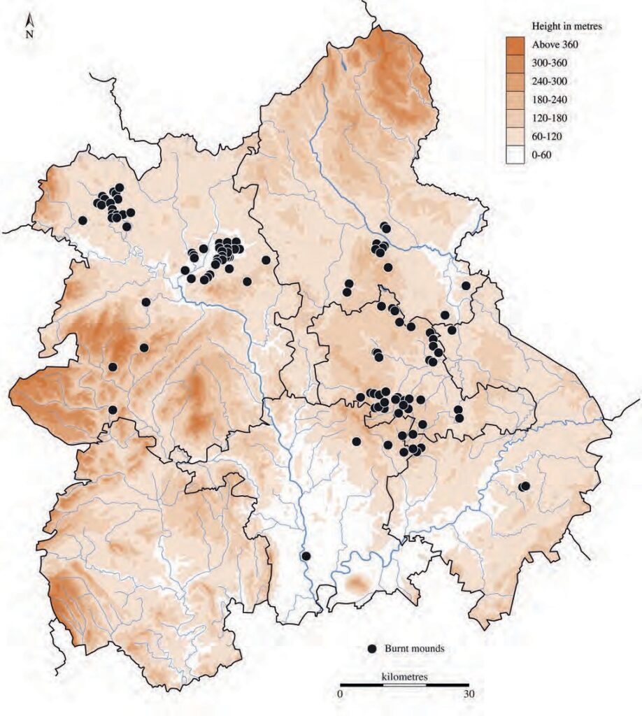
Parts of the West Midlands, especially around Birmingham, are renowned for burnt mounds (Fig 3.1) which are potentially of great importance for the reconstruction of the palaeoenvironment, as they are usually associated with the survival of charcoal and other environmental indicators (see also below). Additionally they may preserve colluvial or alluvial deposits underneath and so provide an extended prehistoric sequence.
Bronze Age sites are most often represented by funerary monuments (Garwood this volume fig 2.12), of which many were dug in the 19th century (eg in Staffordshire; C Wardle, pers comm), and relatively few in more modern times (eg at Holt in Worcestershire, (Hunt et al 1986). In contrast settlement sites have so far generally proved elusive. Funerary barrows might be expected to be some way from any occupation sites due to their prominent location, and so provide little clue about the whereabouts of settlement. Some flat cemeteries of the period associated with cremations have been located (Fig 3.2), especially in Warwickshire (at Ryton-on-Dunsmore; Bateman 1976- 7), and in Shropshire (at Bromfield; Stanford 1982), both being suggested to be Middle rather than Late Bronze Age by Brück (1995, 247). Sometimes Iron Age hillforts have seen prior occupation such as the Breiddin (Musson et al 1991), but on lowland sites there have been few traces of ordinary domestic settlement. Burnt mounds are a prominent feature of some parts of the region being so far recorded in Birmingham, Warwickshire, Staffordshire, and Shropshire (Fig 3.1). These perhaps provide one of the best chances of finding Bronze Age domestic settlement, as they may be located close by (Hodder in prep). Where Late Bronze Age sites have been excavated, so far they have often been unenclosed, as well as extensive, settlements (eg Sharpstone Hill Site A in Shropshire (Wigley in prep a), and Kemerton in Worcestershire (Jackson and Napthan 1998).

Ritual sites are not commonly known in the region. Ritual sites such as the Mitchell’s Fold stone circle in Shropshire may have continued to hold a ritual significance but excavated remains of such sites are very rare, a possible recent example being the Perdiswell penannular ditch near Worcester which was interpreted as a palisaded enclosure for ceremonial use with associated dating of the mid 2nd millennium BC (Griffin et al 2002).
Some progress has been made with reconstructing the landscape of the lower Severn and Avon valleys in the Bronze Age, where extensive clearance of woodland had occurred by the Middle Bronze Age on the terraces of the lower Severn valley, though clearance on the floodplain was generally much later, occurring during the Iron Age to Saxon period. This contrasts with the Avon valley (Worcestershire and Warwickshire) where the floodplain was cleared earlier (Brown 1982). Palaeoenvironmental research in the Severn estuary area (eg Rippon 2001) is also relevant to an understanding of the Severn valley in this period. Geoarchaeology also makes an important contribution but has been little used except for some pioneering studies, in particular by Shotton (1978), by Taylor and Lewin (1996) in the upper Severn valley, and more recently by Macklin et al (2003) in the Arrow valley of Herefordshire. In some cases it has been demonstrated that woodland clearance was followed by the development of heathland (as in Warwickshire; Palmer in prep). More, however, needs to be done on this front, not least in regard to understanding the impact of climatic deterioration in the first half of the 1st millennium BC (Pearson in prep), and current research at Wellington Quarry will make an important contribution through the study of sediments (Payne and Jordan 2004) and pollen (Greig 2004).
In the Iron Age period settlement becomes more visible as it is often enclosed by ditches which show up clearly on aerial photographs, though at the same time funerary practice becomes even less evident. The general appearance is of a landscape being more intensively farmed and increasingly subdivided, including with new types of boundary represented by pits and posthole alignments (eg in Warwickshire; Palmer in prep), and with the use of natural boundaries.

By the Middle Iron Age, enclosures were in widespread use often associated with roundhouses (eg Fig 3.3), and this pattern remains consistent throughout the Late Iron Age as well. Lowland farmsteads have been located and also excavated (eg at Fisherwick in Staffordshire; Smith 1979). Though roundhouses can sometimes be seen to succeed each other the time span of individual sites is often unclear and so it remains uncertain whether or not there was a very long-lived stable community. Few sites of this period have generally been excavated in the region, but the evidence so far, for instance in Worcestershire (eg at Throckmorton; S Griffin, pers comm), suggests that once a lowland settlement was established there was relatively little radical change to its layout before final wholesale abandonment. This gives the impression that individual small settlements may have shifted to a new location rather than older sites being modified, though in the Welsh Marches there is more evidence of site refurbishment and continuity (A Wigley, pers comm). However, most data-sets from fieldwork on Iron Age settlement sites have been relatively limited, with only two exceptions which are at Beckford (Worcestershire) and at Wasperton (Warwickshire). In the case of the M6 toll-road fieldwork the scarcity of Iron Age settlement was indicated in the vicinity of Birmingham (M Hodder, pers comm), and other linear projects also seem to indicate that Iron Age features are not often encountered, where a number of these projects have criss-crossed the countryside, as for instance in Worcestershire. However, care should be taken that this is not necessarily interpreted as absence of activity, as there may be other explanations such as a greater dependence on stock rearing.

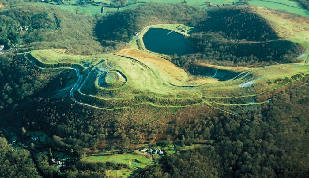
Hillforts of the West Midlands (Fig 3.4) are a particularly prominent feature of the remnant Iron Age landscape (eg Fig 3.5), though little explored archaeologically, except for Stanford’s major fieldwork in Shropshire and Herefordshire in the 1960s–1970s (eg Stanford 1974) and, more recently, the publication of the excavation at Conderton Camp on Bredon Hill (Thomas 2005), and of large-scale earthwork survey on the Malverns (Bowden 2005). This lack of investigation is especially the case in Staffordshire (C Wardle, pers comm). Where earlier fieldwork was undertaken prior to the current framework of pottery study being established from the 1980s onwards, there is now a need to re-examine earlier fieldwork critically, and to bring it up to date. Such sites for reconsideration should include the Bredon Hill excavations of Hencken (1938). And where counties contain large undeveloped upland tracts, as in Staffordshire, then it would be opportune to carry out extensive survey in order to identify wider landscape features potentially relating to hillforts (Wardle in prep).
So far there has been little detailed research carried out in a discrete region to see how sites compare, and to provide greater opportunity for understanding differing elements in the same wider landscape, as has been carried out at Danebury in Hampshire (Cunliffe 1984). The publication of a series of important sites in the vicinity of Bredon Hill (Worcestershire; Conderton and Bredon Hill hillforts, and Beckford), however, will move a long way towards presenting such a case-study of this type for part of the region. Early wider landscape features such as linear banks have been suggested by Historic Landscape Characterisation (HLC) analysis in Herefordshire, and these would be important new evidence, if proven (White in prep). Other such linear boundaries have also been suggested for elsewhere in the region, such as Hob Ditch Causeway in Solihull and Warwickshire (M Hodder, pers comm).
Overall there should be efforts to test blank areas where geology militates against the easier prospection techniques. In both Warwickshire (Palmer in prep) and Worcestershire (Hurst in prep b) some surprisingly extensive settlements have recently been discovered on less well-drained geologies. These may be the richer sites, and the gravel sites, where so much archaeological effort has been expended, may be marginal by comparison. The need to see the wider landscape remains paramount and, where sites are without environmental prospects, there should be some consideration of off-site sampling, in order to study the local environment of site settlement.
The intensification in arable farming during the Iron Age recognised in many areas of the country is difficult to reliably infer from plant macrofossil evidence. Widespread and relatively abundant charred cereal crop waste has been recorded on settlement sites, such as at Beckford in Worcestershire (Colledge 1990; Colledge undated), at Wasperton on the Warwickshire Avon (Bowker 1983), and on some hillfort sites, for example at Midsummer Hill (Colledge 1981). However, equally, crop residues are sparse and other evidence is suggestive of a more pastoral economy elsewhere, for example at Wyre Piddle and Throckmorton in the Vale of Evesham where large areas were sampled for this evidence (Pearson in prep). It is also possible that stock-rearing evidenced in the Romano-British period may have been a continuation of a widespread earlier practice (see Roman Chapter). It may be possible to carry out research into this aspect of landscape using regional pollen sequences. Some evidence has tentatively been interpreted as indicating an increase in arable activity, for example at Wellington Quarry (Greig 2004), although it is often difficult to detect arable indicators as they are frequently swamped by the grassland component on lowland floodplain sites (K Head, pers comm).

Following the flat cremation burials of the Bronze Age the people themselves remain somewhat elusive (Brück 1995), as few human remains have been found in the region (Fig 3.6). A possible bog burial, normally assigned a Late Bronze Age date, occurred at Whixall Moss (Shropshire; Mullin 2003). Where assumptions have been questioned and unaccompanied inhumations (even in barrows) have been tested, these have sometimes turned out to be Iron Age in date (eg at Church Lench in Worcestershire; Griffin et al 2006). At Church Lawford in Warwickshire a mini ring ditch was also dated to the Late Iron Age (Palmer in prep), and an Iron Age inhumation probably set within an earlier ring ditch was found at Bromfield (A Wigley, pers comm). The discovery of odd human bones across settlement sites seems to be a feature which, as yet, has no explanation, though it tends to imply that bodies (or parts of) were not immediately buried. Comparing the date of these isolated bones with other associated finds would be useful to determine if these were likely to be items of ancestral significance. Though occasional individual inhumations and finds of human bone are the norm, sometimes at hillforts larger quantities have come to light as at Sutton Walls (Kenyon 1953) and at Bredon Hill (Hencken 1938).
Though more thought is now being given to the symbolic significance of the environment there are few clues to the landscape of the mind and of religious practice in the Iron Age. The best evidence of this is the practice of depositing objects in special places, including for instance objects which have been recovered from special pits and formerly wet locations in Warwickshire (Palmer in prep).
The material culture of the Bronze Age comprised a range of artefacts, including worked flint for everyday use and copper alloy metalwork finds, for instance of the Middle Bronze Age (cf Vine 1982), the latter providing a spectacular impression of the rarer and more valuable objects that some members of that society had access to, and in some cases giving us an insight into ritual practice. To some extent the latter is true of the Iron Age as well, though by this time there is a greater quantity of other material objects too. Where stratified finds have been recovered in association with burnt mounds there has been very little pottery, suggesting that on some types of site there may have been little use of pottery (Hodder in prep), which seems to confirm the specialised nature of this type of site. On the rare occasions where pottery has been relatively plentiful (ie at Kemerton in south Worcestershire) it was not found in the ploughsoil, which may be accounted for by the usual assumption that it had not survived here. However, the great majority of the material assemblage recovered during the Kemerton excavation had been deliberately deposited in the secondary fills of large features (R Jackson, pers comm), so that it is possible that few finds may ever have been available for incorporation into the ploughsoil. If so, these observations have important potential implications for our ability to identify the settlement sites of this period from the more conventional methods of fieldwork such as fieldwalking.
The extent to which Bronze Age objects were exchanged over distance is less clear, though the raw materials, for instance for metal working, were obviously available across the whole region from outside sources. At Bromfield in Shropshire (Stanford 1982) pottery from the nearby Clee Hills predominated, whereas at Kemerton (Worcestershire) a variety of different pottery fabrics, including from both local and non-local sources (from c30km away), suggested that the diverse Iron Age network of supply can be extended back into the Bronze Age (A Woodward, pers comm). In a similar vein stone axes (Group XII) produced from just over the Shropshire border into Wales, at Corndon Hill, are widely distributed into this region, but especially found west of the Severn (Shotton et al 1951).
Some Bronze Age sites have produced considerable quantities of pottery and, contrary to popular archaeological belief, sites have also been discovered through pottery and other artefacts being found during fieldwalking, occasionally in some profusion as at Whitchurch in Warwickshire (Hingley 1996, 12). It has, however, been suggested that chronologies of other parts of the country may not apply in the West Midlands, as there is a possibility that Middle Bronze Age pottery continued to be used into the Late Bronze Age (Hingley 1996, 20), though recent evidence from Kemerton does not bear this out for south Worcestershire (R Jackson, pers comm).

The ceramic transition from the Late Bronze Age to the Early Iron Age is still a problematical area for the West Midlands (Fig 3.7), mainly because of the sparsity of material of this date (Hancocks in prep). The picture changes radically in the Middle Iron Age, when the central and southern part of the region become associated with some distinctive regional pottery fabrics (Fig 3.8). The Malvern Hills of the Worcestershire/ Herefordshire border in particular became associated with pottery production, and parts of either Gloucestershire or Herefordshire, depending on where the palaeozoic limestone tempered ware (Group B1) pottery originated (Peacock 1968; Morris 1982) continued into the Iron Age as ceramic sources. Several different ceramic producers seem to have emerged in a common ceramic tradition. Salt production also became an established industry at Droitwich at this time, and the salt-makers would have needed to have recourse to, or indeed develop, trade/exchange networks, as their product obviously needed access to a wide region to make larger scale production worthwhile. The common style of the pottery, and the broad correspondence of the Droitwich salt and Dobunnic coin distributions (cf Morris 1985, fig 6, and Allen 1961, fig 16 respectively and Fig 3.9), are of interest as they suggest some common cultural traits that may reflect a common political/tribal affiliation (Hurst 2001) across the southern part of the West Midlands area.

The notable regional pottery studies of the 1960s saw some of the first definitions of fabrics using petrology in this country (Peacock 1965-7), including Iron Age fabrics (Peacock 1968), but this has not been followed up with fieldwork to locate the production areas in more detail. The largest assemblages of finds from the region still remain unpublished, in the case of Beckford in Worcestershire and Wasperton in Warwickshire, both excavated
in the 1970s. This situation has, of course, severely disadvantaged research in this region, and is very unfortunate given the flying start given to the region by the work of David Peacock and Elaine Morris in the 1960s and 1970s respectively. The way forward is for the data from both these major sites to be computerised and additional dating of ceramics to be carried out using residues for AMS dating in view of the time that has passed since the original excavation of these sites, and in the case of Beckford this is currently under way. Other assemblages now in museum collections may form useful subjects for research in order to extract greater information where these still exist as viable archives (eg the 1935-7 Bredon hillfort excavation; Hurst and Jackson 2006).

Other Iron Age artefact types are also characteristic of parts of this region and the distribution patterns of spit-shaped iron currency bars (Allen 1967; Fig 3.9) and of other artefacts tend to corroborate the idea of a cultural zone in the south-west section of the West Midlands (Hurst 2001). In particular the distribution patterns of Late Iron Age coin findspots have been used to trace a similar region traditionally assigned to the Dobunni (Allen 1961; van Arsdell 1994), whose capitals have been reputed to have been at Minchinhampton and Bagendon in Gloucestershire. The other major tribe usually assigned to the study area is the Cornovii, who have normally been placed in Shropshire and west Staffordshire. Otherwise, the West Midlands area of the present survey was largely peripheral to a number of other tribes, such as the Corieltauvi in eastern Staffordshire and north Warwickshire.
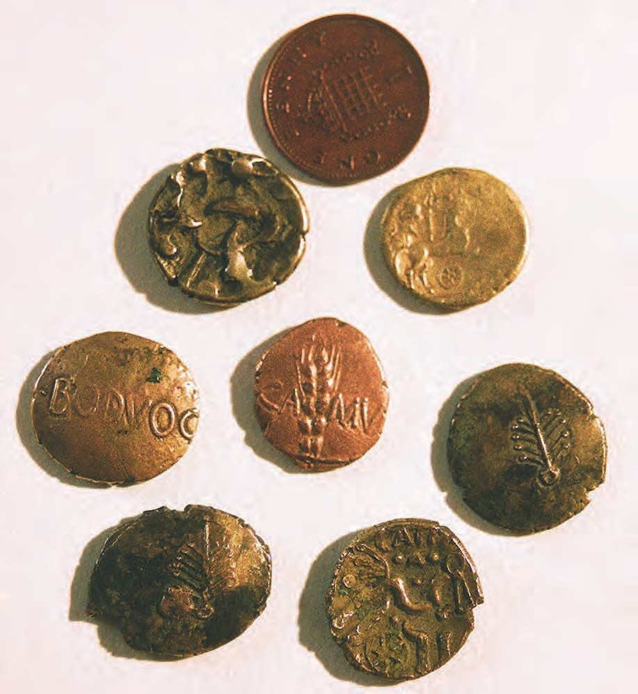
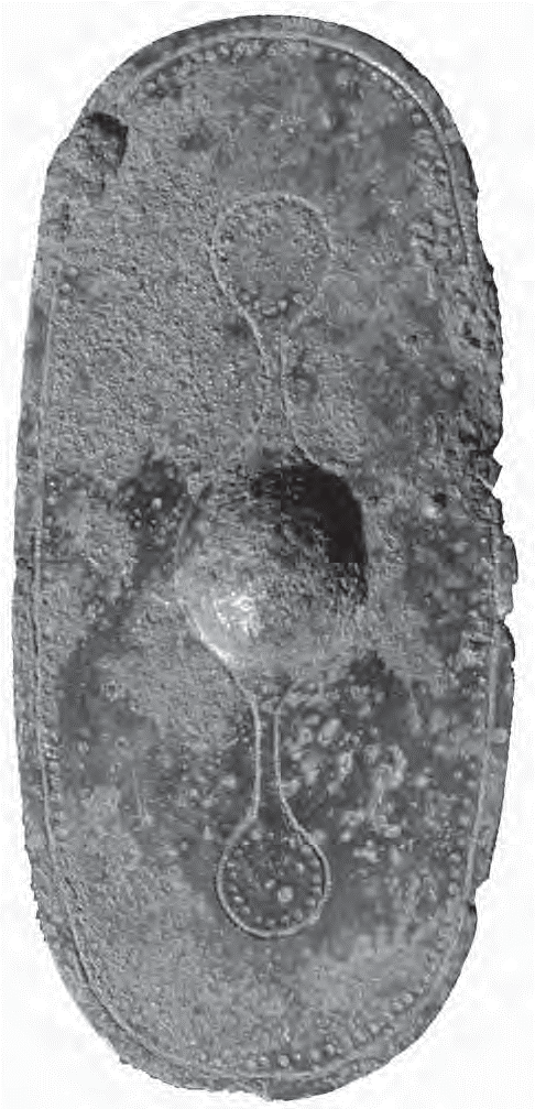
Overall, the impression is that material culture was sparse in artefactual terms and may have been measured more in terms of stock or stockpiles of livestock and crops, although The Portable Antiquities Scheme (PAS) will make a major contribution to the study of objects and will be an important resource for the future, as long as the data being collected are appropriately managed. The range of metalwork objects dated to the Iron Age (eg Figs 3.11-3.13), however, is completely different from the Bronze Age, indicating the considerable changes at work. Rich and elaborate objects have been recovered in the West Midlands from both Bronze Age and Iron Age periods. For instance, several gold (eg Fig 3.11) and bronze torcs are known from Staffordshire (Wardle in prep; Fig 3.9). The recording of larger numbers of objects than before is allowing the West Midlands to develop a distinctive character of its own, and in Staffordshire, for instance, such finds contradict the apparent material impoverishment of Iron Age culture (Wardle in prep). The number of Iron Age lynchpin terminals and pieces of horse-riding equipment coming to light has been the subject of interest (Bolton in prep; Fig 3.9), such objects often being elaborately decorated, and therefore indicative of display and high status.

Perhaps because data is still insufficient there has, as yet, been little study of the economic potential of landholdings of individual settlements, such as that carried out for some Romano-British settlement, where models of consumption and productivity were constructed in order to gain a more basic economic appreciation of this period (eg Applebaum 1975). However, as more sites come to light, this type of analysis may become more feasible.
Regionality is likely to have much to do with local geography and topography and the particular response that this entails. Clearly there was much variation. For instance, ‘hillforts’ are predictably common in some hilly areas such as Herefordshire, but interestingly are less common on the uplands of Staffordshire (Fig 3.4).
In the Middle and Late Bronze Age the Clee Hill dolerite-tempered pottery occurs west of the River Severn but does not reach sites such as Ryton-on-Dunsmore, suggesting a fairly localised distribution (D Mullin, pers comm). Droitwich salt containers (Morris 1985; Morris 1994), Dobunnic coins and spit-shaped currency bars all coincide in much the same part of the region (Hurst 2001), though apparently produced in different parts of that region. In Shropshire briquetage is more common than pottery (ie White in prep), but this is not the case in Herefordshire or Worcestershire. Observations like these, based on the trade and exchange of artefacts, may lead eventually to the definition of specific sub-regions, and more localised areas.
Cropmarks are prolific in number, especially for the Iron Age, but studies of these, in an effort to characterise settlement types, are so far uncommon. Though there has been classification of cropmark sites in north Herefordshire and Shropshire (Whimster 1989), this has not been followed up systematically by excavation in these areas to characterise types of site by date and association. But such surveys remain crucial to the future as their wide geographical range and synthetic analysis provide data for comparison with other parts of the region, and beyond.
So far, therefore, it is difficult to define cultural differences in much detail as there has been too little concerted excavation. However, it is already possible to chart an inherent regionality of trade/exchange of some types of objects within the West Midlands region in the Middle and later Iron Age, and this indicates a core area in south Worcestershire and north Gloucestershire with distinct ‘frontiers’, for instance to the north (beyond the Birmingham plateau); and to the east (the Thames valley). This suggests a cultural and/or economic region, which may in turn reflect political/tribal groupings of the Iron Age (Cunliffe 1991; Hurst 2001). The development of this cultural uniformity, despite a natural barrier such as the Cotswold scarp, makes it more likely that this has some real significance. In this context the definition of areas which are ‘marginal’ to other areas should be exercised with care in the light of the relatively low level of information available for regions such as the West Midlands.
Over the period of the 1500 years from the Middle Bronze Age to the end of the Iron Age there must have been numerous changes in processes.
Raw metals for metal working are most likely to have been mainly imported from outside the region, though it has not yet been confirmed whether copper sources in Shropshire were significantly exploited at this early period (A Wigley, pers comm). The Roman importation of iron ore for smelting at Worcester may give pause for thought about whether this was a tradition with earlier roots. Ariconium (Weston under Penyard, south Herefordshire) was clearly engaged in Iron Age iron production and the number of finds of coins suggests that it also functioned as a centre for distribution (Van Arsdell 1994; Jackson 2000). Another industry indicating larger scale production than just for local consumption is represented by the Droitwich salt industry, and the pottery production centres of the Malverns and nearby areas. Though the salt containers (briquetage) are found on many sites from c 6th-5th centuries BC onwards (Morris 1985), none
of the production at Droitwich has yet been dated to this early period. This may imply that the technology used for salt making by the later Iron Age, and which is now well known from several sites in Droitwich (eg Woodiwiss 1992), was not the same as that used in the earlier period. Though, of course, the other possibility is that it took place elsewhere in Droitwich and has not yet come to light.
Likewise there is a general lack of sites associated with pottery production despite the products being well known across much of the region for about 600 years at least. It is rare that ceramic production sites using open firing techniques can be evidenced in the archaeological record due to their superficial character, but given that this region is the centre for several prominent industries of this type it should be the focus of fieldwork when the occasion arises, as there may be special circumstances where remains could be attributed to pottery production with careful excavation and interpretation.

Several areas have now produced good evidence of landscape organisation in the Bronze Age. At Kemerton this consisted of ditched trackways and fields (R Jackson, pers comm). Substantial linear boundaries of this date have also been noted on several sites, for instance, in south Worcestershire (Childswickham; Patrick and Hurst 2004), and in Warwickshire (Palmer in prep), and potentially under the earthworks of British Camp on the Malverns (Bowden 2005), and on the Long Mynd in Shropshire (D Mullin, pers comm). Recent research has shown that such landscapes follow a similar pattern to that seen in the Thames valley (Yates, pers comm). It is also possible that the cross-ridge dykes and numerous pit alignments in Shropshire date to this period (A Wigley, pers comm), and similar pit alignments datable to the Late Bronze Age or Early Iron Age have been recorded in Staffordshire at Whitemoor Haye (Coates 1997).
Iron Age fields have been more elusive in this region, and there have been too few identifications. Where detailed surveying has been possible, for instance on the Malvern Hills, such fields have been lacking, indicating a long preference for pastoralism in this area (Bowden 2005). Although the overall picture may be somewhat unclear from the environmental evidence, the storage pits at Beckford, and the 4-post structures in the hillforts (usually interpreted as for grain storage), are isolated examples which may imply considerable change to the arable farming economy in the region.
The main research topics may be currently defined as follows:
Rather than allowing the difficulties of radiocarbon dating to deter its use for dating in the Iron Age, on the contrary this technique should be used more often. It should be undertaken by the better laboratories, which are able to deliver the tightest dates, and so may require larger samples (high precision), or, if smaller samples are taken, AMS dating should be used. Ideally a series of dates from related stratigraphy should be obtained, with the possibility that Bayesian statistics might refine the dating.
There should not be an over-reliance on style in the study of ceramics, and any stylistic dating should be backed up by scientific dating, preferably by AMS dating of associated residues. Fabric descriptions should be given to the standard described by the Prehistoric Pottery Research Group (1995) and related wherever possible to regional fabric-type series.
Care should be taken to carry out other scientific dating, such as archaeo-magnetic dating of any ceramic ovens or kiln structures.
The broad pattern of landscape development is understood to mean an expansion of agricultural land-use from the Bronze Age into the Iron Age, though the dating and local character of this is still poorly understood due to limited evidence from sites and especially from environmental evidence. Where there is the potential for palaeoenvironmental investigation this should be followed up, and in some areas this may involve survey to locate local wetland sites (eg identifying smaller peat bogs) which have been largely overlooked, and where limited investigation so far has provided valuable landscape evidence (Hurst in prep b; Pearson in prep).
The location of Bronze Age settlement presents considerable difficulties, but burnt mounds (Fig 3.1) may present a good opportunity if the area around them was to be prioritised for prospection (Hodder in prep). Fieldwalking and geophysics may be appropriate techniques in these circumstances, as demonstrated in Warwickshire (Palmer in prep), in order to create a wider context.
There needs to be a clearer understanding of whether later prehistoric sites can be identified by other means than aerial photography, and in particular as to whether they are susceptible to discovery by fieldwalking (see Hingley 1996 for a positive account, now supported by the evidence of at least two sites in Worcestershire). Extensive settlements without major boundary ditches would be difficult to even locate by aerial photography, and so it is important to be clear about the most advantageous methods of site detection for this period. There is also some evidence that even where Bronze Age pottery was in general use it does not always get incorporated into surface deposits in any quantity but is instead found buried in the deeper features (ie at Kemerton in south Worcestershire). Therefore, in the case of new sites attention should be given to the ploughsoil to establish how far sites are detectable through fieldwalking and other field techniques. Assessment of the effectiveness of current field techniques will have important potential implications for our ability to identify the settlement sites of this period by more conventional methods such as fieldwalking rather than relying on techniques like aerial photography, which tend to reveal only certain types of site on certain geologies. For instance, the mapping and dating of Holocene terraces and palaeochannels in river valleys, as on the River Arrow in Herefordshire, will contribute to a better understanding of past land use and settlement development (C Moffett, pers comm).
Hillforts are a characteristic settlement type in the region (Fig 3.4), part of the ‘hillfort zone’ of western England and Wales (Cunliffe 1991). Their obvious nature has made them prone to passive management protection, tending to remove this resource from the research cycle, despite the success of modern non-invasive techniques (eg Bowden 2005). Since these sites are so important for both the Bronze Age and Iron Age in this region, with even basic aspects such as their chronology and function still in question, there should be an active research engagement to ensure that they continue to play their part in any developing understanding of the Iron Age. This situation should also give added impetus to the investigation of hillforts reputed to lie in some of the more urban areas (Hodder 2004, 45).
There should be consistent recording of artefacts using recognised typologies and reference series. Where these have been maintained over many years, such as the stone
axe and Celtic coin indexes, efforts should be made to continue these vitally important research resources. These specialist databases should be maintained with easy access for the submission of data and as a source of material for comparison and identification. The Portable Antiquities Scheme has a function in ensuring as much information as possible is incorporated in some of these specialist databases. Similarly more local reference series and databases such as the pottery fabric-type series of both Worcestershire and Warwickshire, for instance, should be supported as major contributors to research in the region. Such systems require expert curation in terms of the criteria for data creation and management, and should be recognised as an important part of the research equation, and so be supported where necessary.
Where finds from the Thames valley cross over into the Severn valley these will be of special significance for dating and cross-referencing the two regions, and the same will be true for between the Severn and Trent valleys. As an example, flint tempered pottery has recently been recovered from Late Iron Age levels of a site at Childswickham near Broadway (Timby 2004). Equally, pottery and salt containers from the middle Severn valley area were widely traded within the West Midlands area, with some trickling into other regions such as the Thames valley (Morris 1985, 351), and such overlaps should be closely scrutinised as being of special interest for the cross-dating of the culture of disparate regions.
There may be occasions when reworking archived and published sites will make a further contribution, in the light of improved dating strategies and methods. The dating of carbonised residues from pots is a particularly promising approach.
This is at the crux of research in that the region needs to develop its own typology of structures and refine its own sequences without the typological models of southern England being slavishly followed. The West Midlands needs greater definition from synthesis, and there should be greater confidence in model building and greater awareness of the larger landscape context that can only come from more excavation (including publication of important unpublished excavations), a greater sense of building on data already accumulated (ie site discussion should be well informed – not particularly easy in a competitive tendering environment), and there should be an active effort to identify and use sites in the process of building local profiles of Middle Bronze Age to Iron Age development, rather than just publishing another site. For larger projects a reasonable level of synthesis should especially be built into briefs, as this in itself would be a desirable outcome of the archaeological intervention.
The processes of change are often poorly dated, with only broad date spans being possible. This needs to be addressed wherever possible with more and better scientific dates. Localised environmental evidence will be one of the best ways of charting change, and providing a physical context for human occupation, independent of the vagaries of site degradation, as well as providing detail about animal husbandry, farming practices, and general landscape management. However, for the latter to be effective there should be consistent methods of recording over a long period of research, which has not been the case to date in many of the more specialist areas of study.
Thanks are owed to the following who delivered papers to the West Midlands Regional Research Framework for Archaeology Assessment session in Worcester in September 2002: Angie Bolton, Hal Dalwood, Annette Hancocks, Mike Hodder, Robin Jackson, Stuart Palmer, Liz Pearson, Chris Wardle, Paul White, Andy Wigley, and Ann Woodward; and to the following who attended the Research Agenda and Strategy meeting at Birmingham in July 2003: Hal Dalwood, Mike Hodder, Robin Jackson, Stuart Palmer, Mike Stokes, Chris Wardle, Phil Watson and Sarah Watt, who, together with Lisa Moffett, Dave Mullin and Simon Woodiwiss, have also commented on an earlier draft of this paper. Angie Bolton (Figs 3.12 and 3.13), Debbie Ford (Fig 3.11), Mike Glyde (Fig 3.5) and Jan Wills (Fig 3.3) kindly made available photographs for inclusion.
Sarah Watt is especially to be thanked for so efficiently keeping an extremely lengthy and involved process of debate on a forward course.