Click here to see how to contribute

Enhance understanding of the environmental background to Mesolithic activity
Summary:
By comparison with some other areas of the country, the Mesolithic environment of the East Midlands is little known. In particular there is little evidence to indicate the extent to which tree cover may have been manipulated to encourage the development of vegetation suites for hunting and foraging. Research into ancient environments has focused on the Pennine uplands of Derbyshire[1] and more recently upon organic deposits retrieved from palaeochannels along the Trent and other major river valleys[2]. In Derbyshire, dated pollen sequences have been obtained[3], together with evidence for the potential modification of vegetation by fire around former lakes and mires[4]. The evidence obtained so far suggests that the deliberate creation of forest clearings is a feature of the later Mesolithic, from after about 8000 cal BC[5][6]. There is a need to obtain more closely dated pollen sequences from upland, riverine and coastal peat deposits and to extend the investigation of ancient environments to include isotope studies of the organic fractions of coastal and riverine sediments. The submerged landscapes of Doggerland also present major opportunities for landscape analysis in the form of submarine palaeochannels, pre-inundation land surfaces and peats (Objective 2H)[7]. Coversand deposits, such as those flanking the eastern edge of the lower Trent Valley[8], also merit special mention. Recent work suggests reworking of some late Devensian coversands in the Early Holocene as a result possibly of Mesolithic clearance and/or climatic change[9]. Additional optically stimulated luminescence (OSL) dating of coversands and pollen analysis may be recommended to elucidate further the chronology of coversand reworking and the history of vegetation change.
Agenda topics addressed 2.1.1-2.1.3; 2.3.1; 2.6.1-2.6.3
Characterise the regional and local evidence for Mesolithic activity
Summary:
The East Midlands is notable for the broad range of environments from which Mesolithic lithic artefacts have been recovered[10], yet this information has generally not informed national syntheses and has yet to be fully exploited in regional research. Early investigations of limestone caves and rock shelters in Derbyshire and Nottinghamshire yielded Mesolithic stone artefacts[11], while later work has revealed surface finds and sometimes deeply stratified collections of lithic artefacts across a wide variety of landscapes[12]. These extend from the Pennine spine to the eroding coastal peats of Lincolnshire, and include such diverse environments as the Coal Measures[13], the terraces and coversands of the Trent Valley[14], the wetlands of the Witham Valley[15] and Humberhead Levels[16], and the claylands of Leicestershire and Northamptonshire[17]. Further investigation by excavation[18] has been very limited, however, while the detail of the surface scatters is often not known. It is important to identify the extent, size and shape of artefact distributions and investigate possible associations with sub-surface features[19] in order to characterise these[20], and field methodologies should be adapted appropriately. Curatorial briefs should highlight areas where there has been little or no surface collection and should recognise the potential for wet sieving to recover artefacts and the role of geophysical prospection. The nature and chronology of the lithic material from the region merits separate consideration (Objectives 2C, 2D and 2E), but it is clear that further review of the surface evidence, together with associated excavation, has much to contribute to our understanding of Mesolithic activity in the region.
Agenda topics addressed: 2.1.1-2.1.3; 2.2.1; 2.2.2; 2.2.4; 2.3.1-2.3.5; 2.5.2; 2.5.3.
Investigate further the earlier Mesolithic lithic resource
Summary:

The East Midlands region is notable for the range and extent of distribution of lithic material, but much of this remains little studied. In particular, Historic Environment Records (HERs) commonly lack detailed information on the nature of artefact assemblages and the range of lithic types represented[21]. There is, therefore, considerable constraint on the value of the lithic assemblages and of the HERs as resources for targeting excavation and research, and further assessment and review of the assemblages is needed[22]. In addition to a few examples of tranchet axes, earlier Mesolithic assemblages are characterised in our region by non-geometric microliths in the form of oblique points, isosceles triangles and elongated trapezoids, together with scrapers and burins. It is suggested that these were collectively adapted for the hunting and butchering of forest species – as exemplified by the classic type sites of Star Carr in east Yorkshire[23] and Deepcar in the Pennines of southern Yorkshire[24]. Further evaluation of the relationship between these assemblages and the latest Palaeolithic artefact groups is also necessary. The lithic artefact resource of the East Midlands thus offers significant scope for investigating the potential size of earlier Mesolithic hunting territories and key issues such as the relationship of upland lithic scatters to those of the lowlands or of cave to open-air sites[25].
Agenda topics addressed: 2.1.1; 2.1.2; 2.2.1-2.2.3; 2.3.2; 2.3.3; 2.4.1-2.4.4; 2.5.2; 2.5.3
Identify changing patterns of lithic artefact use in the later Mesolithic
Summary:
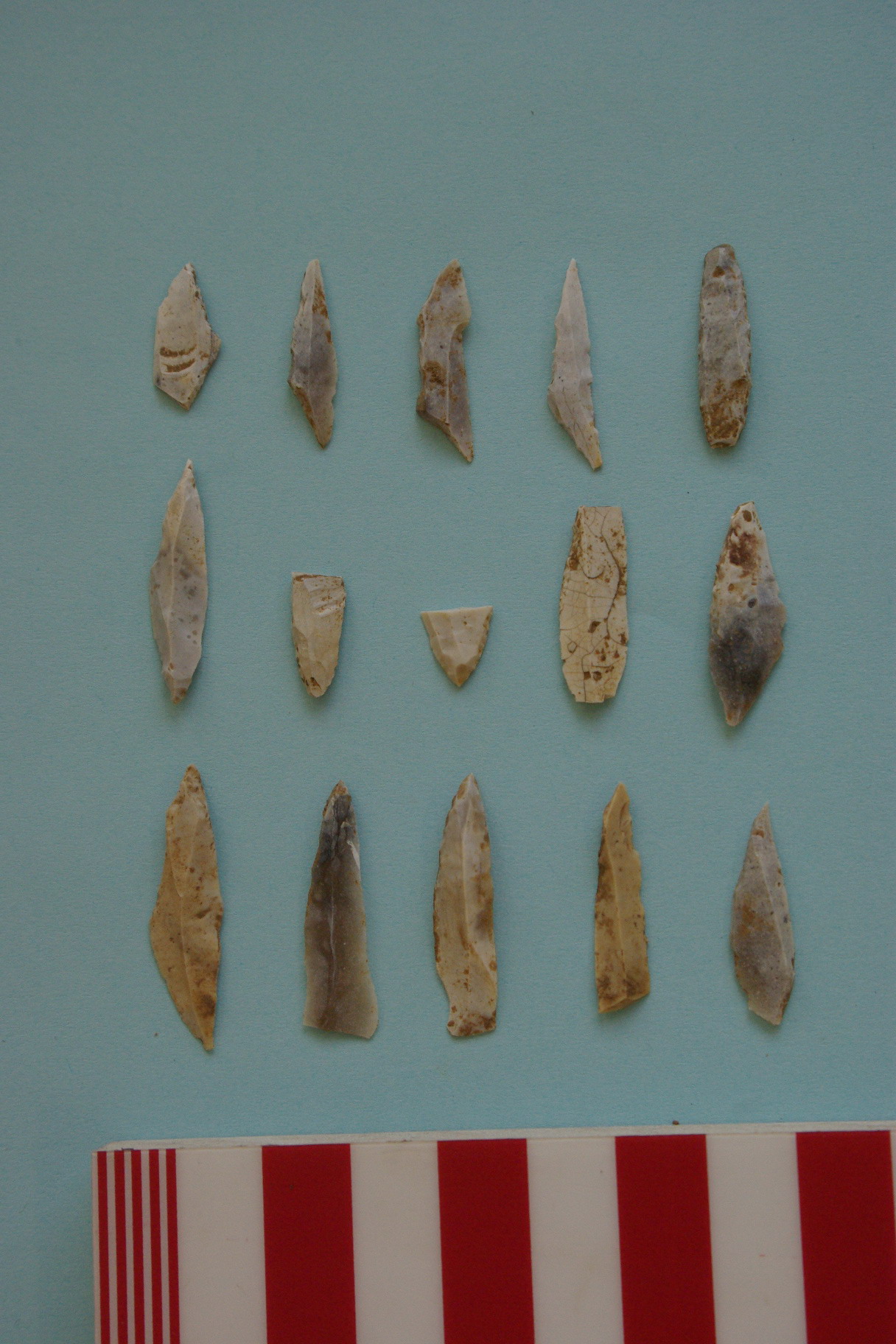
The shortcomings in our documentation and understanding of East Midlands lithic material have been noted above (Objectives 2B and 2C). Later Mesolithic assemblages are typified by a wide variety of smaller geometric forms, including scalene and isosceles triangles, rhomboids, crescents and backed rods[26]. It has been suggested that changes in lithic styles between the earlier and later Mesolithic are indicative not of a change in the animals being hunted but of increasing complexity in the hunting weapons that were used[27]. Detailed examination of microlith assemblages suggests the existence of ‘style zones’ independent of European traditions[28], which might signify the development of sub-regional territories[29]. With ameliorating climate and enhanced plant and animal resources, hunting territories may have shrunk in size; this in turn may have encouraged a semi-sedentary life style, built around regular access to areas which had been cleared of trees to encourage more predictable supplies of game[30]. There are suggestions also that the traditional dichotomy between an earlier and a later Mesolithic may be an over-simplification of a more complex sequence, including an intermediate stage exemplified by Lincolnshire and Northamptonshire artefact assemblages related typologically to the so-called ‘Horsham industries’ of areas farther south[31] and by a recently excavated assemblage from Asfordby in Leicestershire[32]. The opportunity exists, therefore, to refine knowledge of East Midlands later Mesolithic assemblages and to attempt definition of chronological, functional and cultural traits.
Agenda topics addressed: 2.1.2; 2.1.3; 2.2.1-2.2.3; 2.3.2; 2.4.1-2.4.4; 2.5.2; 2.5.3.
Provenancing lithic raw materials: identify patterns of mobility
Summary:
Image 6-1B The Pre-Anglian Bytham and Ancaster river systems
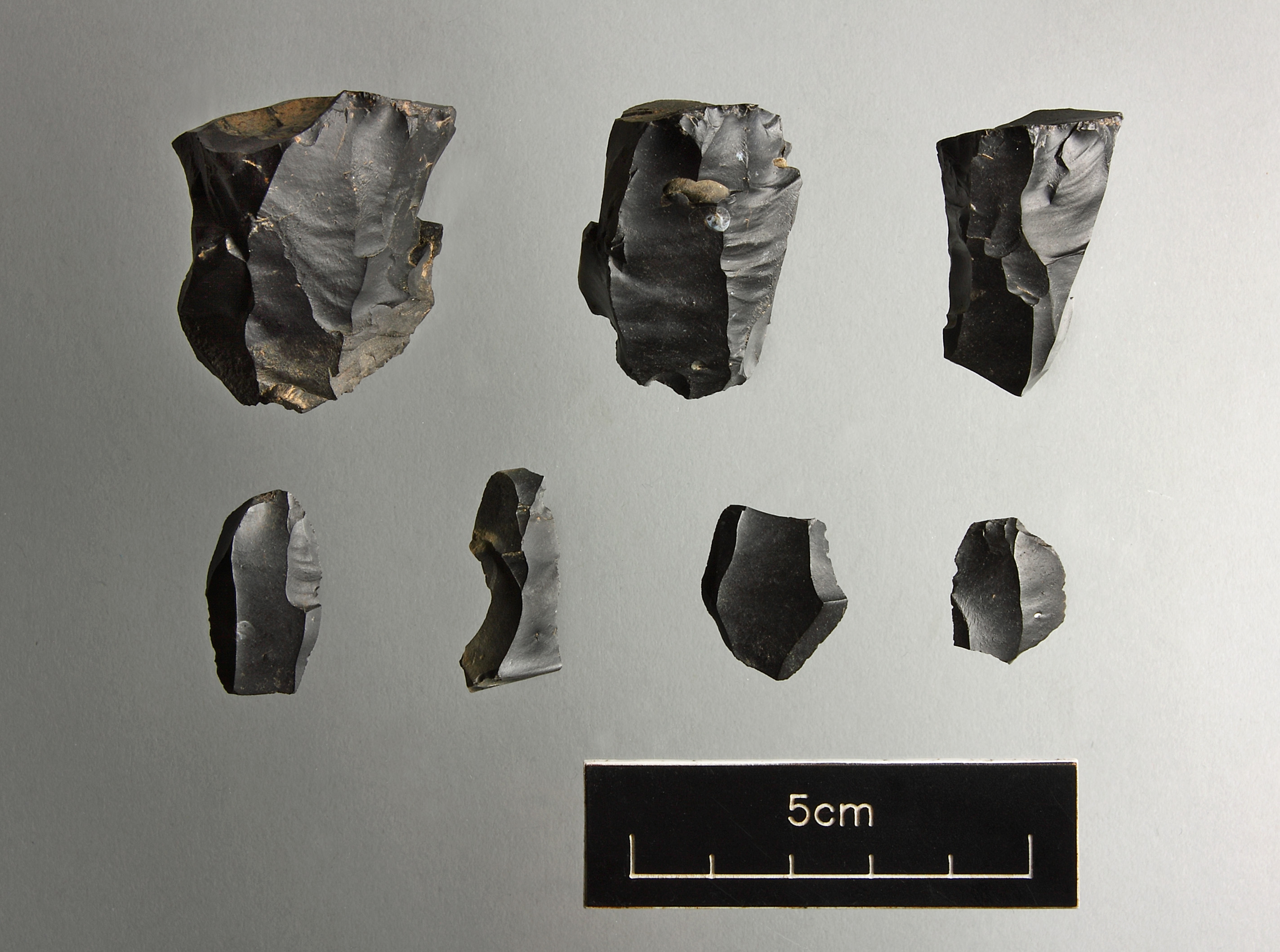
Studies of earlier Mesolithic stone artefacts from south Pennine sites such as Deepcarr in Yorkshire[33] and lowland sites such as Misterton Carr[34] and Swarkestone Lowes[35] have provided persuasive evidence for the movement of raw materials within and beyond the East Midlands, and emphasise the potential of trace element and other scientific techniques for studies of changing patterns of mobility (e.g. by trace element analysis of worked stone and potential source materials)[36]. Determination of possible raw material sources is complicated by the possibility of glacial redeposition of hard rock, which in turn demands detailed study of the composition of local tills and fluvioglacial deposits. In the case of Deepcar-type assemblages from the south Pennines, analysis has shown them to include pre-formed blade cores of a distinctive opaque, mottled, grey-cream flint brought from sources no closer than the Trent Valley and knapped on site, presumably to enhance the hunting kit[37]. This may imply regular annual movements within large territories spanning upland and lowland zones[38]. The evidence for movement of other raw materials such as grey chert is more ambiguous[39], and further scientific research is needed to investigate potential sources. Particular emphasis should be placed upon refining our knowledge of earlier Mesolithic mobility patterns and testing the hypothesis that there was a shift in the later Mesolithic towards an emphasis upon more locally based resources[40].
Waterswallows Lane, Buxton, Derbyshire: recent excavations of an early activity focus at the interface between the Dark and White Peak unearthed a wide range of later Mesolithic and Neolithic finds, including non-local grey chert artefacts that are the focus of current study (photograph: Mike Andrews; reproduced by permission of ArcHeritage)
Agenda topics addressed: 2.5.1
Develop a regional lithic raw material reference collection
Summary
Studies of variations in lithic raw material use has been central to many discussions of Mesolithic assemblage chronology and provenance in the East Midlands and beyond[41] and this remains a key theme in the current Strategy. The region’s lithic resource base needs to be explicitly researched as an aid to studies of material recovered during fieldwalking and other archaeological investigations, including the rich and largely untapped resource of unstudied artefact collections buried in museum archives. To facilitate this, our understanding of raw materials should be standardised through the establishment of a readily accessible reference collection. This should include material from areas beyond the region, bearing in mind the mobility of Mesolithic groups and hence the wide range of potential raw material sources, and it is hoped will address the plea of lithic specialists for increased awareness of available raw materials and their properties[42]. This collection would also be useful for studies of the lithic resource of other prehistoric periods, and hence may be highlighted as a key cross-period priority.

The diversity of potential raw materials is illustrated by this sample of water-worn rocks retrieved from the Trent gravels, deposited during various stages of the Pleistocene by meltwater-enriched rivers:
Conglomerate pebble from the Triassic (Bunter)
1. Well cemented orthoquartzite;
2. Poorly cemented orthoquartzite;
3. Metaquartzite;
4. Vein quartz;
5. Schorl;
6. Flint;
7. Carboniferous chert;
8. Rhaxella chert
(Source: Bridgland, D R, Howard, A J, White, M J and White, T S 2006 The Trent Valley: Archaeology and Landscapes of the Ice Age. Durham University; © Trent Valley Palaeolithic Project)
Agenda topics addressed: 2.5.1
Investigate the topographic locations of activity foci
Summary
More attention should be paid to the topographical attributes of Mesolithic activity foci, which have been recorded in a wide variety of locations. Prominent or elevated sites seem often to have been favoured for open-air sites[43], including hilltops and, in regions of subdued topography, subtle ridges and sand islands[44]. Proximity to wetland resources may have been important, to judge by sites such as Misterton Carr[45] and the many lithic scatters spread across river terraces[46], and many more sites may lie buried beneath alluvium, colluvium, coversands or peat[47]. Fieldwalking and test-pitting surveys have also retrieved material from a wide range of other topographic zones across the region[48], and there is much to be learnt about locational strategies during this period. There are significant opportunities to identify associations between specific activities and distinctive topographies, although many questions remain regarding the prevailing vegetation cover. Consideration should also be given to the nature of Mesolithic activity in locations attracting Neolithic settlement or burial. There may be differences between the two periods: Mesolithic finds at Lismore Fields, for example, spread across a low plateau that was later a focus of Neolithic settlement[49], while the chambered cairn at Whitwell[50] occupied a site that, in common with other cairn locations, yielded no trace of Mesolithic activity.

Mesolithic fieldwalking finds recorded by the Washingborough Archaeological Group in the Witham Valley. The lidar image shows higher (>2mOD) areas of the valley floor (green), lower-lying areas and watercourses (blue shades). Much of the Mesolithic valley floor was later covered by peat, but modern drainage and peat wastage have exposed the earlier land surface (lidar data courtesy of the Environment Agency; processed imagery by Archaeological Project Services)
Agenda topics addressed: 2.1.1-2.1.3; 2.2.1; 2.2.2; 2.2.4; 2.3.1; 2.3.3
Investigate the transition from the Mesolithic to Neolithic
Summary:
Once it seemed easy: whatever the precise mechanics of the conversion, the Mesolithic was characterised by hunter-gatherers, while the Neolithic was populated by settled farmers. Hard and fast distinctions between the Mesolithic and Neolithic are now increasingly difficult to maintain, although the question of the extent to which societies were ‘Mesolithic’ or ‘Neolithic’ still seems valid[51]. Key issues of concern include the continuity of essentially Mesolithic lifeways beyond the fifth millennium BC and the degree to which Early Neolithic populations engaged in agriculture. With notable exceptions such as Lismore Fields[52], evidence for arable farming in the form of querns or cereal grains of undoubted Early Neolithic date remains rare in the East Midlands[53].

Holme Dyke, Gonalston, Nottinghamshire: Early Neolithic bowl placed in the bottom of one of several shallow pits distinguished principally from the terrace sands by their more compact fills and associated heat-shattered stones (Knight and Howard 2004, 66-67; photograph: Lee Elliott).3.
Nevertheless, discoveries of early faunal remains indicate a new interest in domesticating animals and the processing of animal products in different ways[54]. In addition, the building of funerary and other ritual or ceremonial monuments, alongside the development of pottery and changes in lithic industries to encompass flake core artefacts and shaped arrowheads at the expense of bladelet types[55], suggests that becoming Neolithic may have been a spiritual conversion as well as a socio-economic or technological one[56]. The issue of changing subsistence strategies and the relationship between Mesolithic and Neolithic lifeways can be addressed in part by consistent sampling of organic material preserved in palaeochannels and other waterlogged or wetland contexts spanning the transition period. Close examination of the occasional features found associated with Mesolithic and Early Neolithic lithic scatters[57] should also be a priority, and should be combined wherever possible with radiocarbon dating and environmental sampling of associated deposits.
Agenda topics addressed: 2.1.3; 2.4.1, 2.4.2; 2.6.1-2.6
Exploring Doggerland: target submarine landscapes and the modern coastline
Summary:

Submerged channels recorded by seismic survey indicate extensive salt marshes that would have provided rich resources for Mesolithic communities (Gaffney, V et al 2009, Fig 3.31; reproduced by permission of the authors)
Submerged channels recorded by seismic survey indicate extensive salt marshes that would have provided rich resources for Mesolithic communities (Gaffney, V et al 2009, Fig 3.31; reproduced by permission of the authors)
Image 6-2!a Submerged channels recorded by seismic survey
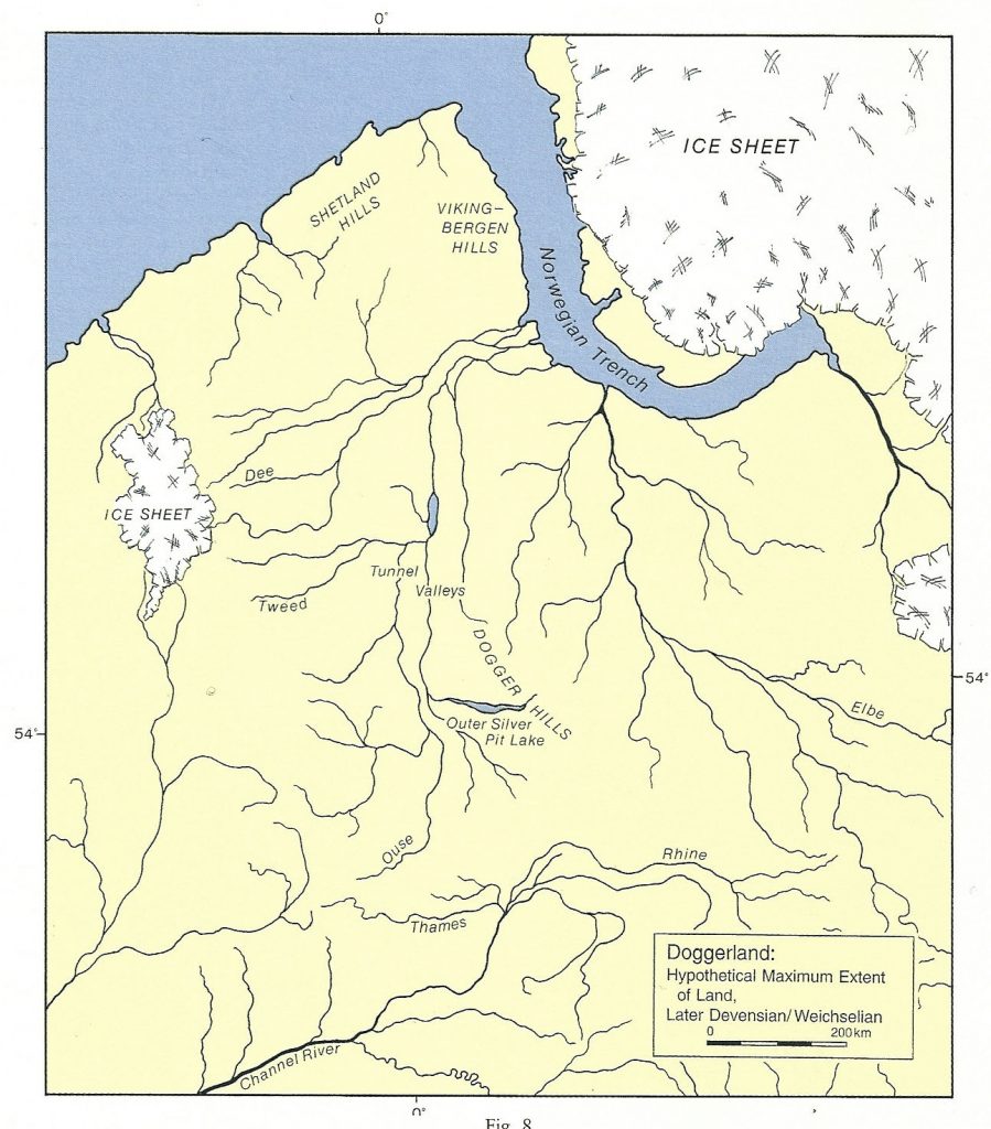
Post-glacial sea-level rises have inundated vast tracts of the low-lying plains that would once have connected eastern England with the Continent[58]. Some 23,000 square kilometres of this submerged landscape, known as Doggerland, have been mapped as part of the North Sea Palaeolandscapes Project, revealing through 3D seismic data a striking image of a broad plain with meandering rivers and lakes[59]. Seismic interpretation techniques have permitted the identification of buried river channels with the potential for significant preservation of cultural and environmental remains that may shed important new light upon landscape developments and changing lifestyles in the Mesolithic and late Palaeolithic. There is a clear need to identify, target, date and sample submarine palaeochannels, pre-inundation land surfaces, and intertidal and submarine peats, and to record and date the artefact assemblages retrieved mainly by dredging[60]. The potential of submerged landscapes along the North Sea coast is well illustrated by on-going investigations in the Humber Estuary[61] and by the results of recently published work to the north of our region in Hartlepool Bay[62]. Investigations in the latter area yielded charcoal residues suggesting clearance of reeds to encourage wildfowl, faunal remains and footprints indicating the presence of aurochs and red deer, and a small collection of lithic artefacts indicating sporadic Mesolithic activity. Coastal erosion may also reveal Mesolithic deposits of environmental and cultural value, in some cases well preserved beneath blown sand, and it is recommended that priority be accorded to the identification and targeted investigation of such sites.
Agenda topics addressed: 2.2.1; 2.2.2; 2.3.3; 2.6.1-2.6.3

The impact of the dramatic rises in sea level that followed melting of the ice sheets that formed during the last glaciation (Devensian) is shown by these maps published in Bryony Colesseminal study of Doggerland (Coles, B J 1998Doggerland: a speculative survey.Proceedings of the Prehistoric Society` 64, 45-81; reproduced by courtesy of Bryony Coles and the Prehistoric Society)
Strategic Objective 2A
Enhance understanding of the environmental background to Mesolithic activity
Summary:
By comparison with some other areas of the country, the Mesolithic environment of the East Midlands is little known. In particular there is little evidence to indicate the extent to which tree cover may have been manipulated to encourage the development of vegetation suites for hunting and foraging. Research into ancient environments has focused on the Pennine uplands of Derbyshire[1] and more recently upon organic deposits retrieved from palaeochannels along the Trent and other major river valleys[2]. In Derbyshire, dated pollen sequences have been obtained[3], together with evidence for the potential modification of vegetation by fire around former lakes and mires[4]. The evidence obtained so far suggests that the deliberate creation of forest clearings is a feature of the later Mesolithic, from after about 8000 cal BC[5][6]. There is a need to obtain more closely dated pollen sequences from upland, riverine and coastal peat deposits and to extend the investigation of ancient environments to include isotope studies of the organic fractions of coastal and riverine sediments. The submerged landscapes of Doggerland also present major opportunities for landscape analysis in the form of submarine palaeochannels, pre-inundation land surfaces and peats (Objective 2H)[7]. Coversand deposits, such as those flanking the eastern edge of the lower Trent Valley[8], also merit special mention. Recent work suggests reworking of some late Devensian coversands in the Early Holocene as a result possibly of Mesolithic clearance and/or climatic change[9]. Additional optically stimulated luminescence (OSL) dating of coversands and pollen analysis may be recommended to elucidate further the chronology of coversand reworking and the history of vegetation change.
Agenda topics addressed 2.1.1-2.1.3; 2.3.1; 2.6.1-2.6.3
Archaeology of the East Midlands: 67, 265
Other research frameworks:
EH Research Strategy for Prehistory 2011: Theme PR1, Topic 9 (Reconstructing Pleistocene and Early Holocene landscapes); Theme PR6, Topics 30 (Human responses to environmental change in prehistory) and 31 (Human interactions with plants and animals in prehistory)
North Sea Prehistory Research and Management Framework 2009, 28: Theme B, 31
Canti, M 2009 A Review of Geoarchaeology in the Midlands of England (English Heritage Research Department Report Series 17). London: English Heritage , 55: Priorities 3.1 (Alluvium), 3.2 (Marine sediments) and 3.3 (Windblown sediments)
EH National Heritage Science Strategy Report 2 2009: Section 3.3.1 (People and the Environment)
References:
[1] Myers, A M 2006 ‘The Mesolithic’ in The Archaeology of the East Midlands, 61-62
[2] Howard, A J and Knight, D 2004 ‘Mesolithic hunter-gatherers’ in Knight, D and Howard, A J Trent Valley Landscapes. Kings Lynn: Heritage Marketing and Publications, 33-35
[3] Tallis, J H and Switsur, V R 1973 ‘Studies on Southern Pennine peats VI: A radiocarbon dated pollen diagram from Featherbed Moss, Derbyshire’. Journal of Ecology 61, 743-751
[4] Hicks, S P 1972 ‘The impact of man on the East Moor of Derbyshire from Mesolithic times’. Archaeological Journal 129, 1-21.
[5] Simmons, I G 2006 The Moorlands of England and Wales: An Environmental History 8000 BC to AD 2000. Edinburgh: Edinburgh University Press, 33-34
[6] Myers 2006, 56
[7] Peeters, H, Murphy, P and Flemming, N 2009 North Sea Prehistory Research and Management Framework, 19-21, 28
[8]Howard and Knight 2004, 32
[9] Howard and Knight 2004, 32, 40-42; compare Baker, C A and Bateman, M D 2010 ‘The residual coversand deposits of central Isle of Thanet, Kent, UK’. Quaternary Newsletter 122, 16-34
Characterise the regional and local evidence for Mesolithic activity
Summary:
The East Midlands is notable for the broad range of environments from which Mesolithic lithic artefacts have been recovered[10], yet this information has generally not informed national syntheses and has yet to be fully exploited in regional research. Early investigations of limestone caves and rock shelters in Derbyshire and Nottinghamshire yielded Mesolithic stone artefacts[11], while later work has revealed surface finds and sometimes deeply stratified collections of lithic artefacts across a wide variety of landscapes[12]. These extend from the Pennine spine to the eroding coastal peats of Lincolnshire, and include such diverse environments as the Coal Measures[13], the terraces and coversands of the Trent Valley[14], the wetlands of the Witham Valley[15] and Humberhead Levels[16], and the claylands of Leicestershire and Northamptonshire[17]. Further investigation by excavation[18] has been very limited, however, while the detail of the surface scatters is often not known. It is important to identify the extent, size and shape of artefact distributions and investigate possible associations with sub-surface features[19] in order to characterise these[20], and field methodologies should be adapted appropriately. Curatorial briefs should highlight areas where there has been little or no surface collection and should recognise the potential for wet sieving to recover artefacts and the role of geophysical prospection. The nature and chronology of the lithic material from the region merits separate consideration (Objectives 2C, 2D and 2E), but it is clear that further review of the surface evidence, together with associated excavation, has much to contribute to our understanding of Mesolithic activity in the region.
Agenda topics addressed: 2.1.1-2.1.3; 2.2.1; 2.2.2; 2.2.4; 2.3.1-2.3.5; 2.5.2; 2.5.3.
Archaeology of the East Midlands: 67.
Other research frameworks:
EH Research Strategy for Prehistory 2011: Theme PR1, Topic 6 (Regional diversity in prehistory); Theme PR2, Topic 14 (Understanding and protecting ‘sites without structures’)
Lithic Studies Society 2004. Research Frameworks for Holocene Lithics in Britain, 2-3.
EH National Heritage Science Strategy Report 2 2009: Section 3.4.1 (Understanding materials)
References:
[10] Myers, A M 2006 ‘The Mesolithic’ in The Archaeology of the East Midlands, 57-64
[11] Myers 2006, 59
[12] Manby, T G 1963 ‘Some Mesolithic sites in the Peak District and the Trent basin’. Derbyshire Archaeological Journal 83, 10-23
[13] Myers 2006, 64; eg Unstone, Derbyshire: see note [18] below
[14] Howard, A J and Knight, D 2004 ‘Mesolithic hunter-gatherers’ in Knight, D and Howard, A J Trent Valley Landscapes. Kings Lynn: Heritage Marketing and Publications, 31-39; see also Objective 2A: notes [17] and [18]
[15] eg Lincoln Eastern Bypass (Area B): Rylatt, J forthcoming Archaeological Investigations along the Proposed Route of the Lincoln Eastern Bypass Heckington: Witham Valley Archaeology Research Committee; Brayford Pool, Lincoln: Rylatt, J and Field, N forthcoming Lincoln University: Excavation of the Delph Pond 2006. Heckington: WVARC
[16] Van de Noort, R and Ellis, S (eds) 1997 Wetland Heritage of the Humberhead Levels. Hull: University of Hull, Humber Wetlands Project, 455-456
[17] eg Clay, P 2002 The Prehistory of the East Midlands Claylands (University of Leicester Archaeology Monograph 9). Leicester: University of Leicester, 26-28
[18] eg Unstone, Derbyshire: full Mesolithic toolkit, with microliths, awls, scrapers, burins and blades as well as a series of associated features; Ataman, K 1978 Excavations at Unstone, Derbyshire, 1978. Unpublished report, North Derbyshire Archaeological Trust; Myers, A M 2001 An Archaeological Resource Assessment of the Mesolithic in Derbyshire (https://www.le.ac.uk/ulas/publications/documents/07dermeso_000.pdf)
[19] eg Unstone: note [17]; Lincoln Eastern Bypass (Area B): Rylatt, J forthcoming and pers comm (includes pits yielding Later Mesolithic flintwork)
[20] Myers 2006, 67-68
Strategic Objective 2C
Investigate further the earlier Mesolithic lithic resource
Summary:
An early Mesolithic and first millennium BC settlement and pit alignments at Swarkestone Lowes, Derbyshire. Derbyshire Archaeological Journal 119, 106-124; reproduced by courtesy of the Derbyshire Archaeological Society)The East Midlands region is notable for the range and extent of distribution of lithic material, but much of this remains little studied. In particular, Historic Environment Records (HERs) commonly lack detailed information on the nature of artefact assemblages and the range of lithic types represented[21]. There is, therefore, considerable constraint on the value of the lithic assemblages and of the HERs as resources for targeting excavation and research, and further assessment and review of the assemblages is needed[22]. In addition to a few examples of tranchet axes, earlier Mesolithic assemblages are characterised in our region by non-geometric microliths in the form of oblique points, isosceles triangles and elongated trapezoids, together with scrapers and burins. It is suggested that these were collectively adapted for the hunting and butchering of forest species – as exemplified by the classic type sites of Star Carr in east Yorkshire[23] and Deepcar in the Pennines of southern Yorkshire[24]. Further evaluation of the relationship between these assemblages and the latest Palaeolithic artefact groups is also necessary. The lithic artefact resource of the East Midlands thus offers significant scope for investigating the potential size of earlier Mesolithic hunting territories and key issues such as the relationship of upland lithic scatters to those of the lowlands or of cave to open-air sites[25].
Agenda topics addressed: 2.1.1; 2.1.2; 2.2.1-2.2.3; 2.3.2; 2.3.3; 2.4.1-2.4.4; 2.5.2; 2.5.3
Archaeology of the East Midlands: 67
Other research frameworks:
EH Research Strategy for Prehistory 2011: Theme PR3, Topics 17 (Technology and society in prehistory) and 18 (Prehistoric material culture in context); Theme PR8, Topic 37 (Realising the potential of prehistoric archives and collections)
Lithic Studies Society 2004 Research Frameworks for Holocene Lithics in Britain, 2-4, 7.
EH National Heritage Science Strategy Report 2 2009: Section 3.4.1 (Understanding materials)
References:
[21] Myers, A M 2006 ‘The Mesolithic’ in The Archaeology of the East Midlands, 59
[22] Lithic Studies Society 2004 Research Frameworks for Holocene Lithics in Britain, 7
[23] Clark, J G D 1954 Excavations at Star Carr: An Early Mesolithic Site at Seamer near Scarborough, Yorkshire. Cambridge: Cambridge University Press, 15-17
[24] Jacobi, R M 1978 ‘Northern England in the eighth millennium bc: An essay’ in Mellars, P (ed) The Early Post-Glacial Settlement of Northern Europe. London: Duckworth, 319-323
[25] Barton, N and Roberts, A 2004 ‘The Mesolithic period in England: Current perspectives and new research’ in Saville, A (ed) Mesolithic Scotland and its Neighbours: The Early Holocene Prehistory of Scotland, its British and Irish Context and some Northern European Perspectives. Edinburgh: Society of Antiquaries of Scotland, 349-350
Strategic Objective 2D
Identify changing patterns of lithic artefact use in the later Mesolithic
Summary:
The shortcomings in our documentation and understanding of East Midlands lithic material have been noted above (Objectives 2B and 2C). Later Mesolithic assemblages are typified by a wide variety of smaller geometric forms, including scalene and isosceles triangles, rhomboids, crescents and backed rods[26]. It has been suggested that changes in lithic styles between the earlier and later Mesolithic are indicative not of a change in the animals being hunted but of increasing complexity in the hunting weapons that were used[27]. Detailed examination of microlith assemblages suggests the existence of ‘style zones’ independent of European traditions[28], which might signify the development of sub-regional territories[29]. With ameliorating climate and enhanced plant and animal resources, hunting territories may have shrunk in size; this in turn may have encouraged a semi-sedentary life style, built around regular access to areas which had been cleared of trees to encourage more predictable supplies of game[30]. There are suggestions also that the traditional dichotomy between an earlier and a later Mesolithic may be an over-simplification of a more complex sequence, including an intermediate stage exemplified by Lincolnshire and Northamptonshire artefact assemblages related typologically to the so-called ‘Horsham industries’ of areas farther south[31] and by a recently excavated assemblage from Asfordby in Leicestershire[32]. The opportunity exists, therefore, to refine knowledge of East Midlands later Mesolithic assemblages and to attempt definition of chronological, functional and cultural traits.
Agenda topics addressed: 2.1.2; 2.1.3; 2.2.1-2.2.3; 2.3.2; 2.4.1-2.4.4; 2.5.2; 2.5.3.
Archaeology of the East Midlands: 67.
Other research frameworks:
EH Research Strategy for Prehistory 2011: Theme PR3, Topics 17 (Technology and society in prehistory) and 18 (Prehistoric material culture in context)
Lithic Studies Society 2004 Research Frameworks for Holocene Lithics in Britain, 2-4.
EH National Heritage Science Strategy Report 2 2009: Section 3.4.1 (Understanding Materials)
References:
[26] Clark, J G D 1932 The Mesolithic Age in Britain. Cambridge: Cambridge University Press, 53; Myers, A M 2006 in The Archaeology of the East Midlands, 54
[27] David, A 1998 ‘Two assemblages of later Mesolithic microliths from Seamer Carr, North Yorkshire: Fact and fancy’ in Ashton, Healey, N F and Pettit, P B (eds) Stone Age Archaeology: Essays in Honour of John Wymer. Oxford: Oxbow Books, 196-206
[28] Jacobi, R M 1976 ‘Britain inside and outside Continental Europe’. Proceedings of the Prehistoric Society 42, 80; Jacobi, R M 1978 ‘Northern England in the eighth millennium bc: An essay’ in Mellars, P (ed) The Early Postglacial Settlement of Northern Europe. London: Duckworth, 295-332
[29] Myers 2006, 54.
[30] As suggested in relation to Star Carr and the North York Moors, see Vyner, B E 2003 ‘The Upper Palaeolithic and the earlier Mesolithic’ in Butlin, R A (ed) Historical Atlas of Yorkshire Otley: Westbury Publishing, 33-34
[31] Summarised by Myers 2006, 53
[32] Jarvis, W. and Cooper, L 2010 ‘Asfordby, Loughborough Road’. Transactions of the Leicestershire Archaeological and Historical Society 84, 347
Provenancing lithic raw materials: identify patterns of mobility
Summary:
Waterswallows Lane, Buxton, Derbyshire: recent excavations of an early activity focus at the interface between the Dark and White Peak unearthed a wide range of later Mesolithic and Neolithic finds, including non-local grey chert artefacts that are the focus of current study (photograph: Mike Andrews; reproduced by permission of ArcHeritage)
Image 6-1B The Pre-Anglian Bytham and Ancaster river systems
Studies of earlier Mesolithic stone artefacts from south Pennine sites such as Deepcarr in Yorkshire[33] and lowland sites such as Misterton Carr[34] and Swarkestone Lowes[35] have provided persuasive evidence for the movement of raw materials within and beyond the East Midlands, and emphasise the potential of trace element and other scientific techniques for studies of changing patterns of mobility (e.g. by trace element analysis of worked stone and potential source materials)[36]. Determination of possible raw material sources is complicated by the possibility of glacial redeposition of hard rock, which in turn demands detailed study of the composition of local tills and fluvioglacial deposits. In the case of Deepcar-type assemblages from the south Pennines, analysis has shown them to include pre-formed blade cores of a distinctive opaque, mottled, grey-cream flint brought from sources no closer than the Trent Valley and knapped on site, presumably to enhance the hunting kit[37]. This may imply regular annual movements within large territories spanning upland and lowland zones[38]. The evidence for movement of other raw materials such as grey chert is more ambiguous[39], and further scientific research is needed to investigate potential sources. Particular emphasis should be placed upon refining our knowledge of earlier Mesolithic mobility patterns and testing the hypothesis that there was a shift in the later Mesolithic towards an emphasis upon more locally based resources[40].
Agenda topics addressed: 2.5.1
Archaeology of the East Midlands: 67
Other research frameworks:
EH Research Strategy for Prehistory 2011: Theme PR3, Topics 17 (Technology and society in prehistory) and 18 (Prehistoric material culture in context); Theme PR5, Topic 27 (Developing scientific techniques for prehistory).
Lithic Studies Society 2004 Research frameworks for Holocene Lithics in Britain, 4-6.
EH National Heritage Science Strategy Report 2 2009: Section 3.4.1 (Understanding materials)
References:
[33] Radley, J and Mellars, P A 1964 ‘A Mesolithic structure at Deepcar, Yorkshire, England, and the affinities of its associated flint industry’. Proceedings of the Prehistoric Society 30, 1-24
[34] Buckland, P C and Dolby, M J 1973 ‘Mesolithic and later material from Misterton Carr, Nottinghamshire’. Transactions of the Thoroton Society 77, 5-33
[35] Garton, D and Brown, J 1999 ‘Flint, quartzite and polished stone artefacts’ in Elliott, L and Knight, D ‘An Early Mesolithic and first millennium BC settlement and pit alignments at Swarkestone Lowes, Derbyshire’. Derbyshire Archaeological Journal 119, 106-124
[36] Myers, A M 2006 ‘The Mesolithic’ in The Archaeology of the East Midlands, 54-55, 67; see also Objective 1F
[37] Howard, A J and Knight, D 2004 ‘Mesolithic hunter-gatherers’ in Knight, D and Howard, A J Trent Valley Landscapes. Kings Lynn: Heritage Marketing and Publications, 40
[38] Howard and Knight 2004, 40; Myers, A M 1989 ‘Lithics, risk and change in the Mesolithic’ in Brooks, I and Phillips, P (eds) Breaking the Stony Silence (British Archaeological Reports British Series 213). Oxford: B.A.R, 131-60
[39] eg Knight, D, Garton, D and Leary, R et al 1998 ‘The Elmton fieldwalking survey: Prehistoric and Romano-British artefact scatters’. Derbyshire Archaeological Journal 118, 78-79
[40] Myers 2006, 54-55
Develop a regional lithic raw material reference collection
Summary
Studies of variations in lithic raw material use has been central to many discussions of Mesolithic assemblage chronology and provenance in the East Midlands and beyond[41] and this remains a key theme in the current Strategy. The region’s lithic resource base needs to be explicitly researched as an aid to studies of material recovered during fieldwalking and other archaeological investigations, including the rich and largely untapped resource of unstudied artefact collections buried in museum archives. To facilitate this, our understanding of raw materials should be standardised through the establishment of a readily accessible reference collection. This should include material from areas beyond the region, bearing in mind the mobility of Mesolithic groups and hence the wide range of potential raw material sources, and it is hoped will address the plea of lithic specialists for increased awareness of available raw materials and their properties[42]. This collection would also be useful for studies of the lithic resource of other prehistoric periods, and hence may be highlighted as a key cross-period priority.
Agenda topics addressed: 2.5.1
Archaeology of the East Midlands: 67
Other research frameworks:
EH Research Strategy for Prehistory 2011: Theme PR3, Topics 17 (Technology and society in prehistory) and 18 (Prehistoric material culture in context); Theme PR8, Topic 37 (Realising the potential of prehistoric archives and collections)
Lithic Studies Society 2004 Research Frameworks for Holocene Lithics in Britain, 7
EH National Heritage Science Strategy Report 2 2009: Section 3.4.1 (Understanding materials)
References:
[41] Myers, A M 2006 ‘The Mesolithic’ in The Archaeology of the East Midlands, 54-55
[42] Lithic Studies Society, 2004 Research Frameworks for Holocene Lithics in Britain, 5-6
The diversity of potential raw materials is illustrated by this sample of water-worn rocks retrieved from the Trent gravels, deposited during various stages of the Pleistocene by meltwater-enriched rivers:
Conglomerate pebble from the Triassic (Bunter)
1. Well cemented orthoquartzite;
2. Poorly cemented orthoquartzite;
3. Metaquartzite;
4. Vein quartz;
5. Schorl;
6. Flint;
7. Carboniferous chert;
8. Rhaxella chert
(Source: Bridgland, D R, Howard, A J, White, M J and White, T S 2006 The Trent Valley: Archaeology and Landscapes of the Ice Age. Durham University; © Trent Valley Palaeolithic Project)
Investigate the topographic locations of activity foci
Summary
More attention should be paid to the topographical attributes of Mesolithic activity foci, which have been recorded in a wide variety of locations. Prominent or elevated sites seem often to have been favoured for open-air sites[43], including hilltops and, in regions of subdued topography, subtle ridges and sand islands[44]. Proximity to wetland resources may have been important, to judge by sites such as Misterton Carr[45] and the many lithic scatters spread across river terraces[46], and many more sites may lie buried beneath alluvium, colluvium, coversands or peat[47]. Fieldwalking and test-pitting surveys have also retrieved material from a wide range of other topographic zones across the region[48], and there is much to be learnt about locational strategies during this period. There are significant opportunities to identify associations between specific activities and distinctive topographies, although many questions remain regarding the prevailing vegetation cover. Consideration should also be given to the nature of Mesolithic activity in locations attracting Neolithic settlement or burial. There may be differences between the two periods: Mesolithic finds at Lismore Fields, for example, spread across a low plateau that was later a focus of Neolithic settlement[49], while the chambered cairn at Whitwell[50] occupied a site that, in common with other cairn locations, yielded no trace of Mesolithic activity.
Agenda topics addressed: 2.1.1-2.1.3; 2.2.1; 2.2.2; 2.2.4; 2.3.1; 2.3.3
Archaeology of the East Midlands: 67
Other research frameworks:
EH Research Strategy for Prehistory 2011: Theme PR2, Topic 10 (Setting prehistoric sites in context)
References:
[43] Myers, A M 2006 ‘The Mesolithic’ in The Archaeology of the East Midlands, 63
[44] eg Lincolnshire Fens: Hall, D and Coles, J 1994 Fenland Survey. An Essay in Landscape and Persistence. London: English Heritage, 27-37
[45] Buckland, P C and Dolby, M J 1973 ‘Mesolithic and later material from Misterton Carr, Nottinghamshire’. Transactions of the Thoroton Society 77, 5-33
[46] Garton, D 2002 ‘Walking fields in South Muskham and its implications for Romano-British cropmark landscapes in Nottinghamshire’. Transactions of the Thoroton Society 106, 27-37
[47] eg Witham Valley: French, C and Rackham, J 2003 ‘Palaeoenvironmental research design for the Witham Valley’ in Catney, S and Start, D (eds) Time and Tide: the Archaeology of the Witham Valley. Heckington: Witham Valley Archaeology Research Committee, 33-42; Rylatt, J and Field, N forthcoming Lincoln University: Excavation of the Delph Pond 2006. Heckington: WVARC
[48] Myers 2006, 62-64
[49] Garton, D 1991 ‘Neolithic settlement in the Peak District’ in Hodges, R and Smith, K (eds) Recent Developments in the Archaeology of the Peak District (University of Sheffield Archaeological Monograph 2). Sheffield: University of Sheffield, 11-14
[50] Vyner, B E and Wall, I 2011 ‘A Neolithic cairn at Whitwell’. Derbyshire Archaeological Journal 131, 1-131
Investigate the transition from the Mesolithic to Neolithic
Summary:
Once it seemed easy: whatever the precise mechanics of the conversion, the Mesolithic was characterised by hunter-gatherers, while the Neolithic was populated by settled farmers. Hard and fast distinctions between the Mesolithic and Neolithic are now increasingly difficult to maintain, although the question of the extent to which societies were ‘Mesolithic’ or ‘Neolithic’ still seems valid[51]. Key issues of concern include the continuity of essentially Mesolithic lifeways beyond the fifth millennium BC and the degree to which Early Neolithic populations engaged in agriculture. With notable exceptions such as Lismore Fields[52], evidence for arable farming in the form of querns or cereal grains of undoubted Early Neolithic date remains rare in the East Midlands[53]. Nevertheless, discoveries of early faunal remains indicate a new interest in domesticating animals and the processing of animal products in different ways[54]. In addition, the building of funerary and other ritual or ceremonial monuments, alongside the development of pottery and changes in lithic industries to encompass flake core artefacts and shaped arrowheads at the expense of bladelet types[55], suggests that becoming Neolithic may have been a spiritual conversion as well as a socio-economic or technological one[56]. The issue of changing subsistence strategies and the relationship between Mesolithic and Neolithic lifeways can be addressed in part by consistent sampling of organic material preserved in palaeochannels and other waterlogged or wetland contexts spanning the transition period. Close examination of the occasional features found associated with Mesolithic and Early Neolithic lithic scatters[57] should also be a priority, and should be combined wherever possible with radiocarbon dating and environmental sampling of associated deposits.
Agenda topics addressed: 2.1.3; 2.4.1, 2.4.2; 2.6.1-2.6.3.
Archaeology of the East Midlands: 67, 86, 265-266.
Other research frameworks:
EH Research Strategy for Prehistory 2011: Theme PR4, Topic 23 (Key transitions in prehistory).
Lithic Studies Society 2004 Research frameworks for Holocene Lithics in Britain, 6.
EH National Heritage Science Strategy Report 2, 2009: Sections 3.2.1 (Chronology) and 3.3.1 (People and the environment).
References:
[#51] Bailey, G 2008 ‘Mesolithic Europe: Overview and new problems’ in Bailey, G and Spikins, P (eds) Mesolithic Europe. Cambridge: Cambridge University Press, 362-364
Holme Dyke, Gonalston, Nottinghamshire: Early Neolithic bowl placed in the bottom of one of several shallow pits distinguished principally from the terrace sands by their more compact fills and associated heat-shattered stones (Knight and Howard 2004, 66-67; photograph: Lee Elliott)
Image 6-2H Early Neolithic bowl, Holme Dyke, Gonalston, Nottinghamshire
[52] Garton, D forthcoming The Excavation of a Mesolithic and Neolithic Settlement at Lismore Fields, Buxton, Derbyshire. Oxford: Oxbow Books
[53] Monckton, A 2006 ‘Environmental archaeology in the East Midlands’ in The Archaeology of the East Midlands, 265-266
[54] Monckton 2006, 265-266
[55] Myers, A M 2006 ‘The Mesolithic’ in The Archaeology of the East Midlands, 56-57
[56] Whittle, A 1996 Europe in the Neolithic. Cambridge: Cambridge University Press, 8
[57] Howard, A J and Knight, D 2004 ‘Mesolithic hunter-gatherers’ in Knight, D and Howard, A J Trent Valley Landscapes. King’s Lynn: Heritage Marketing and Publications, 38; eg Lincoln Eastern Bypass (Area B): Rylatt, J forthcoming Archaeological Investigations along the Proposed Route of the Lincoln Eastern Bypass. Heckington: Witham Valley Archaeology Research Committee
Exploring Doggerland: target submarine landscapes and the modern coastline
Summary:
Submerged channels recorded by seismic survey indicate extensive salt marshes that would have provided rich resources for Mesolithic communities (Gaffney, V et al 2009, Fig 3.31; reproduced by permission of the authors)
Image 6-2!a Submerged channels recorded by seismic survey
Post-glacial sea-level rises have inundated vast tracts of the low-lying plains that would once have connected eastern England with the Continent[58]. Some 23,000 square kilometres of this submerged landscape, known as Doggerland, have been mapped as part of the North Sea Palaeolandscapes Project, revealing through 3D seismic data a striking image of a broad plain with meandering rivers and lakes[59]. Seismic interpretation techniques have permitted the identification of buried river channels with the potential for significant preservation of cultural and environmental remains that may shed important new light upon landscape developments and changing lifestyles in the Mesolithic and late Palaeolithic. There is a clear need to identify, target, date and sample submarine palaeochannels, pre-inundation land surfaces, and intertidal and submarine peats, and to record and date the artefact assemblages retrieved mainly by dredging[60]. The potential of submerged landscapes along the North Sea coast is well illustrated by on-going investigations in the Humber Estuary[61] and by the results of recently published work to the north of our region in Hartlepool Bay[62]. Investigations in the latter area yielded charcoal residues suggesting clearance of reeds to encourage wildfowl, faunal remains and footprints indicating the presence of aurochs and red deer, and a small collection of lithic artefacts indicating sporadic Mesolithic activity. Coastal erosion may also reveal Mesolithic deposits of environmental and cultural value, in some cases well preserved beneath blown sand, and it is recommended that priority be accorded to the identification and targeted investigation of such sites.
Agenda topics addressed: 2.2.1; 2.2.2; 2.3.3; 2.6.1-2.6.3
Other research frameworks:
EH Research Strategy for Prehistory 2011: Theme PR1, Topic 8 (Submerged prehistoric landscapes); Theme PR6, Topic 30 (Human responses to environmental change in prehistory)
North Sea Prehistory Research and Management Framework, 28-31: Themes B, E, F and G.
Canti, M 2009 A Review of Geoarchaeology in the Midlands of England: Priority 3.2 (Marine sediments). London: English Heritage, 55
EH National Heritage Science Strategy Report 2 2009: Section 3.5.1 (Detecting and imaging).
References:
[58]Coles, B J 1998 ‘Doggerland: A speculative survey’. Proceedings of the Prehistoric Society 64, 45-81
[59] Gaffney, V, Fitch, S and Smith, D 2009 Europe’s Lost World: The Rediscovery of Doggerland (CBA Research Report 160). York: Council for British Archaeology
[60] North Sea Prehistory Research and Management Framework, 19-24
[61] Humber Regional Environmental Characterisation Project (http://www.humberrecgis.org.uk/hu/)
[62] Waughman, M 2005 Archaeology and Environment of Submerged Landscapes in Hartlepool Bay, England (Tees Archaeology Monograph 2). Hartlepool: Tees Archaeology, 129-131
The impact of the dramatic rises in sea level that followed melting of the ice sheets that formed during the last glaciation (Devensian) is shown by these maps published in Bryony Colesseminal study of Doggerland (Coles, B J 1998Doggerland: a speculative survey.Proceedings of the Prehistoric Society` 64, 45-81; reproduced by courtesy of Bryony Coles and the Prehistoric Society)